The CH49 6 postcode sector is within the county of Merseyside.
Did you know? According to the 2021 Census, the CH49 6 postcode sector is home to a bustling 3,728 residents!
Given that each sector allows for 400 unique postcode combinations. Letters C, I, K, M, O and V are not allowed in the last two letters of a postcode. With 86 postcodes already in use, this leaves 314 units available.
The largest settlements in the CH49 6 postal code are WIRRAL and Upton.
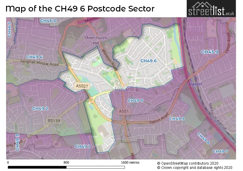
The CH49 6 Postcode shares a border with CH49 1 (WIRRAL, Upton, Greasby), CH49 4 (WIRRAL, Upton), CH49 0 (WIRRAL), CH43 9 (PRENTON) and CH49 2 (WIRRAL, Greasby).
The sector is within the post town of WIRRAL.
CH49 6 is a postcode sector within the CH49 postcode district which is within the CH Chester postcode area.
The Royal Mail delivery office for the CH49 6 postal sector is the Upton (ch) Delivery Office.
The area of the CH49 6 postcode sector is 0.49 square miles which is 1.27 square kilometres or 314.42 square acres.
The CH49 6 postcode sector is crossed by the M53 motorway.

Map of the CH49 6 Postcode Sector
Explore the CH49 6 postcode sector by using our free interactive map.
| C | H | 4 | 9 | - | 6 | X | X |
| C | H | 4 | 9 | Space | 6 | Letter | Letter |
Official List of Streets
Upton (14 Streets)
WIRRAL (50 Streets)
Unofficial Streets or Alternative Spellings
WIRRAL
ARROWE PARK ROAD ATHOLL DUNCAN DRIVE FORD LANE FORD ROAD MOLYNEUX CLOSEUpton
SAUGHALL MASSIE ROAD ARKILL GARDENS ARROW BROOK PATH AUGHTON COURT CHAMPIONS BUSINESS PARK HEATH DRIVE LINK MALLEY CLOSE QUINESWAY SIMPSON PLACE THE SPINNEY THE STABLES UPTON BY-PASS UPTON COURT UPTON MEADOWGreasby
GREASBY ROADWeather Forecast for CH49 6
Press Button to Show Forecast for Upton (Merseyside)
| Time Period | Icon | Description | Temperature | Rain Probability | Wind |
|---|---|---|---|---|---|
| 18:00 to 21:00 | Cloudy | 10.0°C (feels like 7.0°C) | 4.00% | NNW 11 mph | |
| 21:00 to 00:00 | Overcast | 10.0°C (feels like 8.0°C) | 7.00% | NW 9 mph |
Press Button to Show Forecast for Upton (Merseyside)
| Time Period | Icon | Description | Temperature | Rain Probability | Wind |
|---|---|---|---|---|---|
| 00:00 to 03:00 | Cloudy | 9.0°C (feels like 8.0°C) | 4.00% | WNW 4 mph | |
| 03:00 to 06:00 | Cloudy | 8.0°C (feels like 6.0°C) | 4.00% | ENE 7 mph | |
| 06:00 to 09:00 | Sunny day | 7.0°C (feels like 5.0°C) | 0.00% | NE 9 mph | |
| 09:00 to 12:00 | Sunny day | 7.0°C (feels like 5.0°C) | 0.00% | NNE 7 mph | |
| 12:00 to 15:00 | Sunny day | 9.0°C (feels like 7.0°C) | 0.00% | NNW 9 mph | |
| 15:00 to 18:00 | Sunny day | 9.0°C (feels like 6.0°C) | 0.00% | NW 11 mph | |
| 18:00 to 21:00 | Sunny day | 8.0°C (feels like 6.0°C) | 0.00% | NW 9 mph | |
| 21:00 to 00:00 | Clear night | 8.0°C (feels like 6.0°C) | 1.00% | NW 7 mph |
Press Button to Show Forecast for Upton (Merseyside)
| Time Period | Icon | Description | Temperature | Rain Probability | Wind |
|---|---|---|---|---|---|
| 00:00 to 03:00 | Cloudy | 8.0°C (feels like 5.0°C) | 4.00% | WNW 9 mph | |
| 03:00 to 06:00 | Cloudy | 7.0°C (feels like 4.0°C) | 5.00% | WNW 11 mph | |
| 06:00 to 09:00 | Cloudy | 8.0°C (feels like 5.0°C) | 7.00% | NW 11 mph | |
| 09:00 to 12:00 | Cloudy | 8.0°C (feels like 5.0°C) | 9.00% | NW 13 mph | |
| 12:00 to 15:00 | Partly cloudy (day) | 9.0°C (feels like 6.0°C) | 5.00% | NW 13 mph | |
| 15:00 to 18:00 | Partly cloudy (day) | 9.0°C (feels like 7.0°C) | 2.00% | NW 11 mph | |
| 18:00 to 21:00 | Cloudy | 9.0°C (feels like 7.0°C) | 4.00% | NW 9 mph | |
| 21:00 to 00:00 | Cloudy | 8.0°C (feels like 6.0°C) | 4.00% | NNE 7 mph |
Press Button to Show Forecast for Upton (Merseyside)
| Time Period | Icon | Description | Temperature | Rain Probability | Wind |
|---|---|---|---|---|---|
| 00:00 to 03:00 | Cloudy | 7.0°C (feels like 5.0°C) | 9.00% | SE 7 mph | |
| 03:00 to 06:00 | Cloudy | 6.0°C (feels like 3.0°C) | 10.00% | SE 7 mph | |
| 06:00 to 09:00 | Cloudy | 6.0°C (feels like 3.0°C) | 16.00% | ESE 9 mph | |
| 09:00 to 12:00 | Cloudy | 7.0°C (feels like 5.0°C) | 14.00% | ESE 9 mph | |
| 12:00 to 15:00 | Cloudy | 9.0°C (feels like 7.0°C) | 11.00% | E 9 mph | |
| 15:00 to 18:00 | Overcast | 10.0°C (feels like 8.0°C) | 15.00% | E 9 mph | |
| 18:00 to 21:00 | Cloudy | 10.0°C (feels like 8.0°C) | 13.00% | ENE 7 mph | |
| 21:00 to 00:00 | Cloudy | 8.0°C (feels like 6.0°C) | 13.00% | E 9 mph |
Press Button to Show Forecast for Upton (Merseyside)
| Time Period | Icon | Description | Temperature | Rain Probability | Wind |
|---|---|---|---|---|---|
| 00:00 to 03:00 | Cloudy | 7.0°C (feels like 4.0°C) | 13.00% | E 11 mph | |
| 03:00 to 06:00 | Cloudy | 7.0°C (feels like 4.0°C) | 18.00% | E 11 mph | |
| 06:00 to 09:00 | Cloudy | 7.0°C (feels like 4.0°C) | 14.00% | E 11 mph | |
| 09:00 to 12:00 | Cloudy | 8.0°C (feels like 6.0°C) | 16.00% | E 11 mph | |
| 12:00 to 15:00 | Cloudy | 10.0°C (feels like 8.0°C) | 16.00% | E 11 mph | |
| 15:00 to 18:00 | Cloudy | 11.0°C (feels like 9.0°C) | 16.00% | NE 11 mph | |
| 18:00 to 21:00 | Cloudy | 10.0°C (feels like 8.0°C) | 13.00% | ENE 11 mph | |
| 21:00 to 00:00 | Light rain | 9.0°C (feels like 7.0°C) | 42.00% | ENE 11 mph |
Schools and Places of Education Within the CH49 6 Postcode Sector
St Joseph's Catholic Primary School Upton
Voluntary aided school
Moreton Road, Wirral, Merseyside, CH49 6LL
Head: Mrs Claire Marrin
Ofsted Rating: Good
Inspection: 2019-04-17 (1833 days ago)
Website: Visit St Joseph's Catholic Primary School Upton Website
Phone: 01516773970
Number of Pupils: 266
Upton Hall School FCJ
Academy converter
Upton, Wirral, Merseyside, CH49 6LJ
Head: Mrs Andrea Gaunt
Ofsted Rating: Outstanding
Inspection: 2022-06-29 (664 days ago)
Website: Visit Upton Hall School FCJ Website
Phone: 01516777696
Number of Pupils: 1016
House Prices in the CH49 6 Postcode Sector
| Type of Property | 2018 Average | 2018 Sales | 2017 Average | 2017 Sales | 2016 Average | 2016 Sales | 2015 Average | 2015 Sales |
|---|---|---|---|---|---|---|---|---|
| Detached | £265,557 | 17 | £312,578 | 18 | £270,765 | 20 | £295,145 | 20 |
| Semi-Detached | £194,403 | 35 | £186,389 | 36 | £190,157 | 30 | £196,900 | 38 |
| Terraced | £164,000 | 1 | £0 | 0 | £114,995 | 1 | £110,667 | 3 |
| Flats | £81,700 | 7 | £88,031 | 13 | £67,286 | 7 | £66,645 | 10 |
Important Postcodes CH49 6 in the Postcode Sector
CH49 6LJ is the postcode for LINGDALE BUILDING, Upton Hall School, Moreton Road, Upton Hall School, Moreton Road, and GERARD BUILDING AND SPORTS HALL, Upton Hall School, Moreton Road
| The CH49 6 Sector is within these Local Authorities |
|
|---|---|
| The CH49 6 Sector is within these Counties |
|
| The CH49 6 Sector is within these Water Company Areas |
|