The CH5 postcode district is a postal district located in the CH Chester postcode area with a population of 42,342 residents according to the 2021 England and Wales Census.
The area of the CH5 postcode district is 21.75 square miles which is 56.34 square kilometres or 13,921.11 acres.
Currently, the CH5 district has about 1111 postcode units spread across 4 geographic postcode sectors.
Given that each sector allows for 400 unique postcode combinations, the district has a capacity of 1,600 postcodes. With 1111 postcodes already in use, this leaves 489 units available.
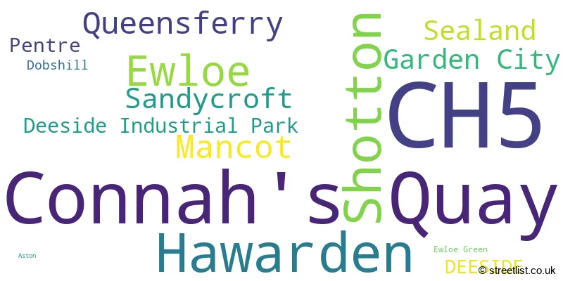
The largest settlement in the CH5 postal code is Connah's Quay followed by CONNAHS QUAY, and Shotton.
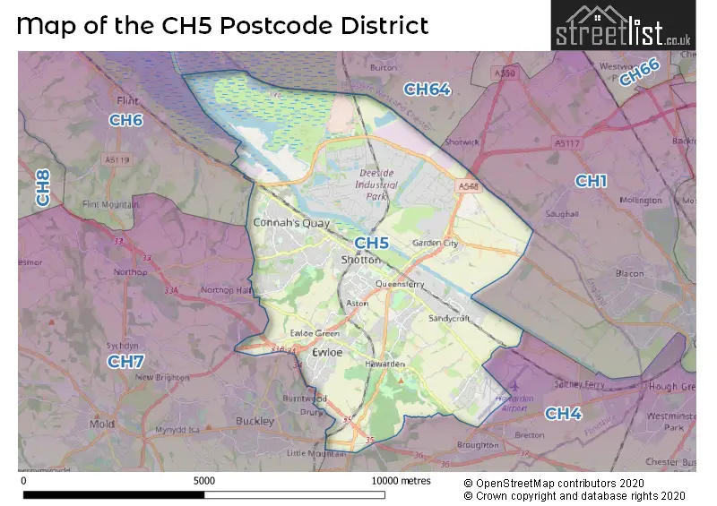
The postcode area has a boundary with Dee Estuary.
The CH5 Postcode shares a border with CH64 (NESTON, Little Neston, Willaston), CH6 (FLINT, BAGILLT, OAKENHOLT), CH1 (CHESTER, Blacon, Saughall), CH4 (CHESTER, SALTNEY, BROUGHTON) and CH7 (BUCKLEY, MOLD, MYNYDD ISA).
In the CH5 postcode district, the primary settlement is DEESIDE, located in the county of Clwyd in Wales. Other significant settlements in the district include Queensferry, Shotton, Deeside Industrial Park, Garden City, Mancot, Pentre, Sandycroft, and Sealand. The main post town within the district is DEESIDE.
For the district CH5, we have data on 5 postcode sectors. Here's a breakdown: The sector CH5 1, covers Shotton and Queensferry in Clwyd. The sector CH5 2, covers Mancot and Sandycroft and Garden City and Sealand in Clwyd. The sector CH5 3, covers Hawarden and Ewloe in Clwyd. The sector CH5 4, covers Connah's Quay in Clwyd. The sector CH5 9 is non-geographic. It's often designated for PO Boxes, large organisations, or special services.

Map of the CH5 Postcode District
Explore the CH5 postcode district by using our free interactive map.
When it comes to local government, postal geography often disregards political borders. However, for a breakdown in the CH5 District: the district mostly encompasses the Sir y Fflint - Flintshire area with a total of 1135 postcodes.
Weather Forecast for CH5
Press Button to Show Forecast for Shotton
| Time Period | Icon | Description | Temperature | Rain Probability | Wind |
|---|---|---|---|---|---|
| 21:00 to 00:00 | Cloudy | 7.0°C (feels like 5.0°C) | 5.00% | NNE 4 mph |
Press Button to Show Forecast for Shotton
| Time Period | Icon | Description | Temperature | Rain Probability | Wind |
|---|---|---|---|---|---|
| 00:00 to 03:00 | Cloudy | 5.0°C (feels like 4.0°C) | 6.00% | SE 4 mph | |
| 03:00 to 06:00 | Cloudy | 4.0°C (feels like 3.0°C) | 5.00% | ESE 4 mph | |
| 06:00 to 09:00 | Partly cloudy (day) | 5.0°C (feels like 3.0°C) | 2.00% | E 4 mph | |
| 09:00 to 12:00 | Cloudy | 8.0°C (feels like 6.0°C) | 5.00% | E 7 mph | |
| 12:00 to 15:00 | Cloudy | 9.0°C (feels like 8.0°C) | 7.00% | E 7 mph | |
| 15:00 to 18:00 | Cloudy | 10.0°C (feels like 9.0°C) | 10.00% | NNE 4 mph | |
| 18:00 to 21:00 | Cloudy | 10.0°C (feels like 8.0°C) | 7.00% | NE 4 mph | |
| 21:00 to 00:00 | Cloudy | 7.0°C (feels like 5.0°C) | 7.00% | NE 4 mph |
Press Button to Show Forecast for Shotton
| Time Period | Icon | Description | Temperature | Rain Probability | Wind |
|---|---|---|---|---|---|
| 00:00 to 03:00 | Cloudy | 5.0°C (feels like 3.0°C) | 11.00% | E 4 mph | |
| 03:00 to 06:00 | Partly cloudy (night) | 4.0°C (feels like 2.0°C) | 8.00% | E 4 mph | |
| 06:00 to 09:00 | Cloudy | 5.0°C (feels like 3.0°C) | 10.00% | E 4 mph | |
| 09:00 to 12:00 | Cloudy | 8.0°C (feels like 6.0°C) | 10.00% | E 7 mph | |
| 12:00 to 15:00 | Overcast | 10.0°C (feels like 8.0°C) | 16.00% | ENE 9 mph | |
| 15:00 to 18:00 | Overcast | 11.0°C (feels like 9.0°C) | 20.00% | NE 9 mph | |
| 18:00 to 21:00 | Cloudy | 10.0°C (feels like 8.0°C) | 17.00% | NE 9 mph | |
| 21:00 to 00:00 | Cloudy | 8.0°C (feels like 6.0°C) | 17.00% | NE 9 mph |
Press Button to Show Forecast for Shotton
| Time Period | Icon | Description | Temperature | Rain Probability | Wind |
|---|---|---|---|---|---|
| 00:00 to 03:00 | Cloudy | 7.0°C (feels like 5.0°C) | 19.00% | NE 9 mph | |
| 03:00 to 06:00 | Cloudy | 7.0°C (feels like 4.0°C) | 19.00% | NNE 9 mph | |
| 06:00 to 09:00 | Light rain | 7.0°C (feels like 5.0°C) | 50.00% | NNE 9 mph | |
| 09:00 to 12:00 | Overcast | 9.0°C (feels like 7.0°C) | 20.00% | NNE 9 mph | |
| 12:00 to 15:00 | Cloudy | 11.0°C (feels like 8.0°C) | 27.00% | N 11 mph | |
| 15:00 to 18:00 | Light rain | 11.0°C (feels like 9.0°C) | 51.00% | N 11 mph | |
| 18:00 to 21:00 | Light rain shower (day) | 11.0°C (feels like 8.0°C) | 37.00% | N 11 mph | |
| 21:00 to 00:00 | Clear night | 8.0°C (feels like 6.0°C) | 10.00% | NW 9 mph |
Where is the CH5 Postcode District?
The data shows that the postcode district CH5 is located in the town of Deeside in the United Kingdom. Deeside is situated in close proximity to several nearby towns. In the southwest direction, Buckley is located at a distance of approximately 3.27 miles. Moving towards the northwest, Flint is situated about 4.69 miles away. To the north, Neston is located at a distance of around 6.06 miles. In the southeast direction, the town of Chester is approximately 7.40 miles away. Finally, in the northeast, Ellesmere Port is situated about 7.78 miles away. Additionally, the postcode district is located approximately 170.13 miles from the center of London.
The district is within the post town of DEESIDE.
The sector has postcodes within the nation of Wales.
The CH5 Postcode District is in the Flintshire and Wrexham region of East Wales within the Wales.
| Postcode Sector | Delivery Office |
|---|---|
| CH5 1 | Deeside Delivery Office |
| CH5 2 | Deeside Delivery Office |
| CH5 3 | Deeside Delivery Office |
| CH5 4 | Deeside Delivery Office |
| C | H | 5 | - | X | X | X |
| C | H | 5 | Space | Numeric | Letter | Letter |
Current Monthly Rental Prices
| # Bedrooms | Min Price | Max Price | Avg Price |
|---|---|---|---|
| 1 | £412 | £575 | £485 |
| 2 | £650 | £800 | £750 |
| 3 | £825 | £1,250 | £1,018 |
| 4 | £1,350 | £1,700 | £1,525 |
Current House Prices
| # Bedrooms | Min Price | Max Price | Avg Price |
|---|---|---|---|
| 4 | £400,000 | £800,000 | £519,333 |
| 5 | £450,000 | £850,000 | £609,167 |
| 6 | £480,000 | £600,000 | £558,333 |
| 8 | £1,000,000 | £1,000,000 | £1,000,000 |
Estate Agents who Operate in the CH5 District
| Logo | Name | Brand Name | Address | Contact Number | Total Properties |
|---|---|---|---|---|---|
 | Hawarden | Reades | Reades House, 3-5 The Highway, Hawarden, Deeside, CH5 3DG | 01244 537537 | 47 |
 | Shotton | The Big Estate Agency | Brook House, Brook Road, Shotton, Deeside, Flintshire, CH5 1HL | 01242 502724 | 29 |
 | Deeside | William Gleave | 22 Chester Road West, Shotton, Deeside, CH5 1BX | 01244 565614 | 27 |
 | Connah's Quay | Keystone Property & Mortgage Centre | 117 High Street, Connah's Quay, Deeside, CH5 4DF | 01244 565300 | 23 |
 | Shotton | Molyneux | 33, Chester Road West, Shotton, Deeside, CH5 1BY | 01244 565542 | 20 |
| Type of Property | 2018 Average | 2018 Sales | 2017 Average | 2017 Sales | 2016 Average | 2016 Sales | 2015 Average | 2015 Sales |
|---|---|---|---|---|---|---|---|---|
| Detached | £249,109 | 197 | £236,222 | 252 | £222,424 | 244 | £209,905 | 235 |
| Semi-Detached | £143,441 | 235 | £137,359 | 253 | £136,550 | 265 | £131,902 | 249 |
| Terraced | £114,358 | 147 | £115,007 | 148 | £118,534 | 130 | £111,042 | 129 |
| Flats | £97,342 | 30 | £86,944 | 27 | £109,655 | 21 | £87,675 | 20 |