The CH63 postcode district is a postal district located in the CH Chester postcode area with a population of 29,359 residents according to the 2021 England and Wales Census.
The area of the CH63 postcode district is 11.26 square miles which is 29.16 square kilometres or 7,206.02 acres.
Currently, the CH63 district has about 823 postcode units spread across 10 geographic postcode sectors.
Given that each sector allows for 400 unique postcode combinations, the district has a capacity of 4,000 postcodes. With 823 postcodes already in use, this leaves 3177 units available.
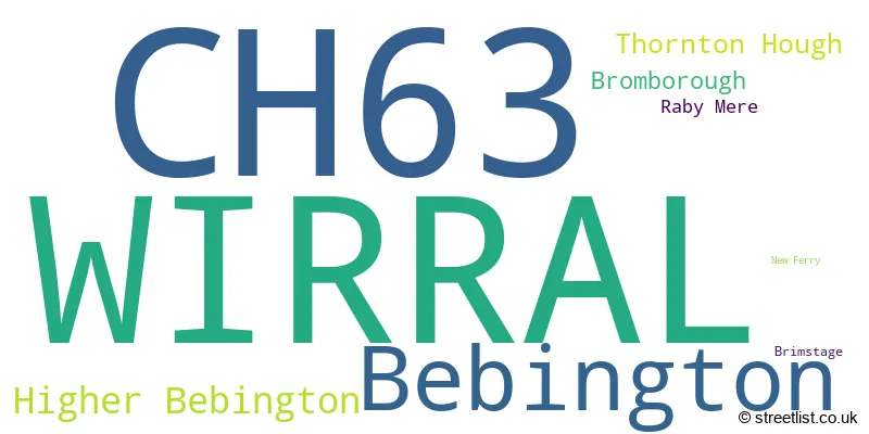
The largest settlement in the CH63 postal code is WIRRAL followed by Bebington, and Higher Bebington.
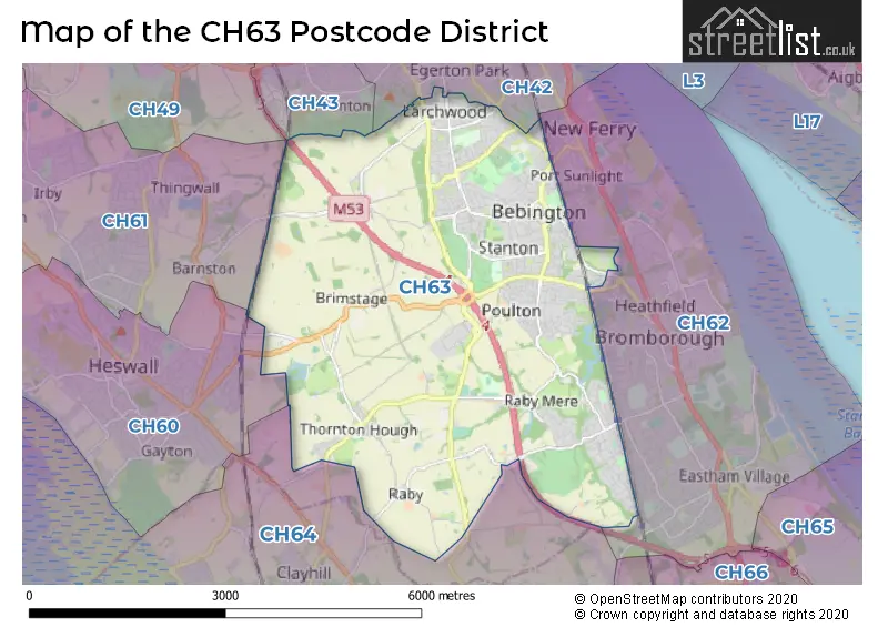
The CH63 Postcode shares a border with CH42 (BIRKENHEAD), CH62 (WIRRAL, Bromborough, Eastham), CH64 (NESTON, Little Neston, Willaston) and CH43 (PRENTON).
In the CH63 postcode district, the primary settlement is Wirral, located in Merseyside, England. The most prominent post town in this district is Wirral. Other significant settlements in the district include Bromborough, New Ferry, Raby Mere, Thornton Hough, Bebington, Higher Bebington, and Brimstage.
For the district CH63, we have data on 10 postcode sectors. Here's a breakdown: The sector CH63 0, covers Wirral in Merseyside. The sector CH63 1, covers Wirral and Thornton Hough in Merseyside. The sector CH63 2, covers Wirral and Bebington in Merseyside. The sector CH63 3, covers Wirral and Bebington in Merseyside. The sector CH63 4, covers Wirral and Thornton Hough in Merseyside. The sector CH63 5, covers Wirral and Bebington in Merseyside. The sector CH63 6, covers Wirral and Higher Bebington in Merseyside. The sector CH63 7, covers Wirral and Bebington in Merseyside. The sector CH63 8, covers Wirral and Bebington and Higher Bebington in Merseyside. The sector CH63 9, covers Wirral in Merseyside.

Map of the CH63 Postcode District
Explore the CH63 postcode district by using our free interactive map.
When it comes to local government, postal geography often disregards political borders. However, for a breakdown in the CH63 District: the district mostly encompasses the Wirral District (B) area with a total of 822 postcodes.
Weather Forecast for CH63
Press Button to Show Forecast for Bebington
| Time Period | Icon | Description | Temperature | Rain Probability | Wind |
|---|---|---|---|---|---|
| 18:00 to 21:00 | Cloudy | 11.0°C (feels like 8.0°C) | 3.00% | NNW 13 mph | |
| 21:00 to 00:00 | Cloudy | 9.0°C (feels like 8.0°C) | 4.00% | NNE 7 mph |
Press Button to Show Forecast for Bebington
| Time Period | Icon | Description | Temperature | Rain Probability | Wind |
|---|---|---|---|---|---|
| 00:00 to 03:00 | Clear night | 8.0°C (feels like 6.0°C) | 0.00% | E 4 mph | |
| 03:00 to 06:00 | Cloudy | 6.0°C (feels like 4.0°C) | 3.00% | SSE 4 mph | |
| 06:00 to 09:00 | Cloudy | 6.0°C (feels like 5.0°C) | 3.00% | SSE 4 mph | |
| 09:00 to 12:00 | Cloudy | 9.0°C (feels like 8.0°C) | 4.00% | W 4 mph | |
| 12:00 to 15:00 | Partly cloudy (day) | 11.0°C (feels like 10.0°C) | 0.00% | NNW 7 mph | |
| 15:00 to 18:00 | Sunny day | 11.0°C (feels like 10.0°C) | 0.00% | NNW 9 mph | |
| 18:00 to 21:00 | Cloudy | 10.0°C (feels like 9.0°C) | 3.00% | NNW 7 mph | |
| 21:00 to 00:00 | Cloudy | 9.0°C (feels like 7.0°C) | 4.00% | NW 4 mph |
Press Button to Show Forecast for Bebington
| Time Period | Icon | Description | Temperature | Rain Probability | Wind |
|---|---|---|---|---|---|
| 00:00 to 03:00 | Partly cloudy (night) | 8.0°C (feels like 7.0°C) | 1.00% | NNW 4 mph | |
| 03:00 to 06:00 | Partly cloudy (night) | 7.0°C (feels like 6.0°C) | 1.00% | N 4 mph | |
| 06:00 to 09:00 | Cloudy | 8.0°C (feels like 6.0°C) | 5.00% | N 4 mph | |
| 09:00 to 12:00 | Cloudy | 10.0°C (feels like 8.0°C) | 5.00% | NNE 7 mph | |
| 12:00 to 15:00 | Overcast | 11.0°C (feels like 9.0°C) | 7.00% | NE 7 mph | |
| 15:00 to 18:00 | Cloudy | 12.0°C (feels like 10.0°C) | 5.00% | NNE 7 mph | |
| 18:00 to 21:00 | Cloudy | 11.0°C (feels like 10.0°C) | 5.00% | NE 7 mph | |
| 21:00 to 00:00 | Cloudy | 9.0°C (feels like 8.0°C) | 5.00% | NE 7 mph |
Press Button to Show Forecast for Bebington
| Time Period | Icon | Description | Temperature | Rain Probability | Wind |
|---|---|---|---|---|---|
| 00:00 to 03:00 | Overcast | 8.0°C (feels like 6.0°C) | 11.00% | E 7 mph | |
| 03:00 to 06:00 | Overcast | 7.0°C (feels like 5.0°C) | 10.00% | SSE 7 mph | |
| 06:00 to 09:00 | Overcast | 7.0°C (feels like 5.0°C) | 13.00% | SSE 7 mph | |
| 09:00 to 12:00 | Overcast | 8.0°C (feels like 7.0°C) | 13.00% | S 7 mph | |
| 12:00 to 15:00 | Cloudy | 10.0°C (feels like 8.0°C) | 13.00% | E 7 mph | |
| 15:00 to 18:00 | Cloudy | 10.0°C (feels like 9.0°C) | 12.00% | ENE 9 mph | |
| 18:00 to 21:00 | Cloudy | 10.0°C (feels like 9.0°C) | 11.00% | NNE 9 mph | |
| 21:00 to 00:00 | Cloudy | 9.0°C (feels like 8.0°C) | 10.00% | E 7 mph |
Press Button to Show Forecast for Bebington
| Time Period | Icon | Description | Temperature | Rain Probability | Wind |
|---|---|---|---|---|---|
| 00:00 to 03:00 | Cloudy | 9.0°C (feels like 7.0°C) | 8.00% | ENE 7 mph | |
| 03:00 to 06:00 | Cloudy | 8.0°C (feels like 7.0°C) | 9.00% | E 7 mph | |
| 06:00 to 09:00 | Cloudy | 8.0°C (feels like 6.0°C) | 7.00% | ENE 7 mph | |
| 09:00 to 12:00 | Partly cloudy (day) | 10.0°C (feels like 8.0°C) | 3.00% | NE 7 mph | |
| 12:00 to 15:00 | Cloudy | 11.0°C (feels like 10.0°C) | 6.00% | NE 9 mph | |
| 15:00 to 18:00 | Cloudy | 12.0°C (feels like 10.0°C) | 6.00% | N 11 mph | |
| 18:00 to 21:00 | Partly cloudy (day) | 11.0°C (feels like 9.0°C) | 3.00% | N 11 mph | |
| 21:00 to 00:00 | Cloudy | 9.0°C (feels like 7.0°C) | 5.00% | NNE 9 mph |
Where is the CH63 Postcode District?
The postcode district for CH63 is located in Wirral. Wirral is a district town situated near several nearby towns. To the south, there is Neston, which is approximately 2.84 miles away. To the north, there is Birkenhead, which is around 2.97 miles away. In the south-east direction, there is Ellesmere Port, approximately 6.55 miles away. Flint is located in the south-west, approximately 7.91 miles away. Finally, Liverpool is in the north-east, approximately 9.30 miles away. Additionally, the distance between CH63 and London is approximately 175.98 miles.
The district is within the post town of WIRRAL.
The sector has postcodes within the nation of England.
The CH63 Postcode District is covers the following regions.
- Wirral - Merseyside - North West (England)
- Cheshire West and Chester - Cheshire - North West (England)
Postcode Sectors within the CH63 District
| Postcode Sector | Delivery Office |
|---|---|
| CH63 0 | New Ferry Delivery Office |
| CH63 1 | New Ferry Delivery Office |
| CH63 2 | New Ferry Delivery Office |
| CH63 3 | New Ferry Delivery Office |
| CH63 4 | New Ferry Delivery Office |
| CH63 5 | New Ferry Delivery Office |
| CH63 6 | New Ferry Delivery Office |
| CH63 7 | New Ferry Delivery Office |
| CH63 8 | New Ferry Delivery Office |
| CH63 9 | New Ferry Delivery Office |
| C | H | 6 | 3 | - | X | X | X |
| C | H | 6 | 3 | Space | Numeric | Letter | Letter |
Current Monthly Rental Prices
| # Bedrooms | Min Price | Max Price | Avg Price |
|---|---|---|---|
| 1 | £425 | £425 | £425 |
| 2 | £725 | £1,350 | £946 |
| 3 | £950 | £1,500 | £1,155 |
Current House Prices
| # Bedrooms | Min Price | Max Price | Avg Price |
|---|---|---|---|
| £550,000 | £550,000 | £550,000 | |
| 3 | £460,000 | £720,000 | £568,333 |
| 4 | £450,000 | £1,200,000 | £634,667 |
| 5 | £495,000 | £800,000 | £617,000 |
| 6 | £750,000 | £750,000 | £750,000 |
Estate Agents who Operate in the CH63 District
| Logo | Name | Brand Name | Address | Contact Number | Total Properties |
|---|---|---|---|---|---|
 | Bebington | Lesley Hooks Estate Agents | 6 Church Road, Bebington, CH63 7PH | 0151 453 7889 | 41 |
 | Bebington | Karl Tatler Estate Agents | 2B Church Road, Bebington, CH63 7PH | 0151 645 7070 | 25 |
 | Bebington | Jones & Chapman | 4 Church Road, Bebington, CH63 7PH | 0151 453 4680 | 12 |
 | Bromborough | Lesley Hooks Estate Agents | 23 Allport Lane, Bromborough, CH62 7HH | 0151 453 3968 | 9 |
 | Wirral Bebington | Martin & Co | 15 Church Road Bebington CH63 7PG | 0151 453 5235 | 8 |
| Type of Property | 2018 Average | 2018 Sales | 2017 Average | 2017 Sales | 2016 Average | 2016 Sales | 2015 Average | 2015 Sales |
|---|---|---|---|---|---|---|---|---|
| Detached | £298,593 | 94 | £289,686 | 101 | £277,609 | 109 | £258,591 | 99 |
| Semi-Detached | £201,826 | 215 | £191,400 | 255 | £183,936 | 231 | £173,679 | 240 |
| Terraced | £152,765 | 50 | £158,113 | 61 | £145,057 | 72 | £134,877 | 60 |
| Flats | £102,242 | 37 | £90,876 | 29 | £86,856 | 33 | £98,474 | 26 |
Hotels within the Postcode Area
We found 4 hotels and guest houses within the CH63 postcode area