The CH7 5 postcode sector is within the county of Clwyd.
Did you know? According to the 2021 Census, the CH7 5 postcode sector is home to a bustling 6,591 residents!
Given that each sector allows for 400 unique postcode combinations. Letters C, I, K, M, O and V are not allowed in the last two letters of a postcode. With 248 postcodes already in use, this leaves 152 units available.
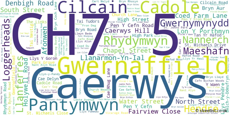
The largest settlement in the CH7 5 postal code is CAERWYS followed by Gwernaffield, and CILCAIN.
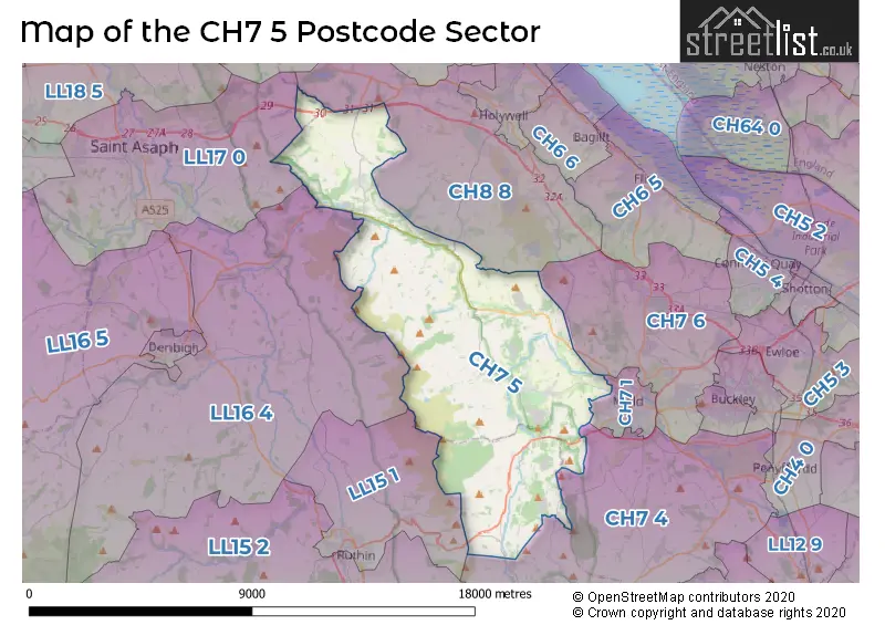
The CH7 5 Postcode shares a border with CH7 4 (LEESWOOD, TREUDDYN, LLANARMON YN IAL), CH7 6 (MYNYDD ISA, NORTHOP HALL, NORTHOP), CH8 8 (Pentre Halkyn, CARMEL, BRYNFORD), CH7 1 (MOLD), LL16 4 (DENBIGH, LLANDYRNOG, BODFARI), LL17 0 (ST ASAPH, ST. ASAPH, RHUALLT) and LL15 1 (RUTHIN, LLANBEDR DYFFRYN CLWYD, RHEWL).
The sector is within the post town of MOLD.
CH7 5 is a postcode sector within the CH7 postcode district which is within the CH Chester postcode area.
The Royal Mail delivery office for the CH7 5 postal sector is the Mold Delivery Office.
The area of the CH7 5 postcode sector is 37.56 square miles which is 97.28 square kilometres or 24,039.54 square acres.

Map of the CH7 5 Postcode Sector
Explore the CH7 5 postcode sector by using our free interactive map.
| C | H | 7 | - | 5 | X | X |
| C | H | 7 | Space | 5 | Letter | Letter |
Official List of Streets
Rhydymwyn (18 Streets)
Caerwys (27 Streets)
Nannerch (14 Streets)
Pantymwyn (10 Streets)
Gwernymynydd (14 Streets)
Afonwen (12 Streets)
Gwernaffield (17 Streets)
Cilcain (20 Streets)
Cadole (1 Streets)
Llanferres (9 Streets)
Hendre (3 Streets)
Maeshafn (3 Streets)
Unofficial Streets or Alternative Spellings
Gwernymynydd
FFORDD LAS GODRER COED SWAN LANE ALLT Y CHWILER BRYN ARTRO AVENUE BWLCH PENBARRAS BWLCH Y DDEUFRYN BYWAY OPEN TO ALL TRAFFIC CAER-MUL COED PEN-Y-BRYN COLOMENDY OEC DOLFECHLAS ROAD DROVERS LANE FFORD Y WAEN FFORDD FREDERICK FFORDD HAFOD FFORDD MAESHAFAN FFORDD MAESHAFN FFORDD MEHEMIA FFORDD-FUDR FFORDD-Y-LLAN FFORDD-Y-PALMANT COEDIOG FFORDD-Y-WAEN FFORDDY BRYN FP53 GLAS-COED GWIBFFORDD GOGLEDD CYMRU / NORTH WALES EXPRESSWAY HAFOD-Y-WERN HEOL D?R HEOL FAWR HEOL-Y-CAPEL HIGH PARK ESTATE LEETE PATH LLWYBR-HIR LLYS-Y-GORON LLYS-Y-PENTRE MAES GARMON LANE MAES LLAN MAES-Y-DRE MINFORDD FIELDS OFFAS DYKE WAY OTHER ROUTE OF PUBLIC ACCESS PANT Y BUARTH PARC-IS-MYNYDD PARC-Y-LLAN PEBBLES BRIDGE PEN-Y-COED PEN-Y-FELIN ROAD PENYCEFN ROAD PENYFRON ROAD PERMISSIVE PATH POST OFFICE LANE TAN-Y-CAE TAN-YR-HAFOD THE WALLED GARDEN TYN-LLAN VILLAGE ROADNercwys
FFORDD GLYNDWRWeather Forecast for CH7 5
Press Button to Show Forecast for Maeshafn Youth Hostel
| Time Period | Icon | Description | Temperature | Rain Probability | Wind |
|---|---|---|---|---|---|
| 00:00 to 03:00 | Cloudy | 2.0°C (feels like -1.0°C) | 5.00% | ESE 7 mph | |
| 03:00 to 06:00 | Cloudy | 1.0°C (feels like -2.0°C) | 4.00% | E 4 mph | |
| 06:00 to 09:00 | Sunny day | 2.0°C (feels like 0.0°C) | 6.00% | E 4 mph | |
| 09:00 to 12:00 | Partly cloudy (day) | 5.0°C (feels like 3.0°C) | 5.00% | ESE 7 mph | |
| 12:00 to 15:00 | Overcast | 7.0°C (feels like 4.0°C) | 12.00% | E 7 mph | |
| 15:00 to 18:00 | Overcast | 7.0°C (feels like 5.0°C) | 15.00% | ENE 7 mph | |
| 18:00 to 21:00 | Cloudy | 6.0°C (feels like 4.0°C) | 9.00% | ENE 4 mph | |
| 21:00 to 00:00 | Cloudy | 2.0°C (feels like 0.0°C) | 9.00% | NNE 4 mph |
Press Button to Show Forecast for Maeshafn Youth Hostel
| Time Period | Icon | Description | Temperature | Rain Probability | Wind |
|---|---|---|---|---|---|
| 00:00 to 03:00 | Partly cloudy (night) | 1.0°C (feels like -1.0°C) | 10.00% | ENE 4 mph | |
| 03:00 to 06:00 | Partly cloudy (night) | 0.0°C (feels like -2.0°C) | 9.00% | ENE 4 mph | |
| 06:00 to 09:00 | Partly cloudy (day) | 2.0°C (feels like 0.0°C) | 8.00% | NE 4 mph | |
| 09:00 to 12:00 | Cloudy | 5.0°C (feels like 3.0°C) | 12.00% | E 9 mph | |
| 12:00 to 15:00 | Cloudy | 7.0°C (feels like 4.0°C) | 15.00% | ENE 9 mph | |
| 15:00 to 18:00 | Overcast | 8.0°C (feels like 5.0°C) | 19.00% | NE 9 mph | |
| 18:00 to 21:00 | Cloudy | 7.0°C (feels like 5.0°C) | 15.00% | NE 7 mph | |
| 21:00 to 00:00 | Light rain | 5.0°C (feels like 2.0°C) | 46.00% | NE 7 mph |
Press Button to Show Forecast for Maeshafn Youth Hostel
| Time Period | Icon | Description | Temperature | Rain Probability | Wind |
|---|---|---|---|---|---|
| 00:00 to 03:00 | Light rain | 4.0°C (feels like 1.0°C) | 46.00% | NNE 7 mph | |
| 03:00 to 06:00 | Light rain | 3.0°C (feels like 1.0°C) | 46.00% | NNE 7 mph | |
| 06:00 to 09:00 | Light rain | 4.0°C (feels like 2.0°C) | 49.00% | NNE 7 mph | |
| 09:00 to 12:00 | Overcast | 7.0°C (feels like 4.0°C) | 24.00% | NNE 9 mph | |
| 12:00 to 15:00 | Overcast | 8.0°C (feels like 5.0°C) | 26.00% | N 9 mph | |
| 15:00 to 18:00 | Light rain | 8.0°C (feels like 6.0°C) | 52.00% | N 9 mph | |
| 18:00 to 21:00 | Cloudy | 8.0°C (feels like 5.0°C) | 17.00% | N 9 mph | |
| 21:00 to 00:00 | Clear night | 5.0°C (feels like 3.0°C) | 9.00% | NW 4 mph |
House Prices in the CH7 5 Postcode Sector
| Type of Property | 2018 Average | 2018 Sales | 2017 Average | 2017 Sales | 2016 Average | 2016 Sales | 2015 Average | 2015 Sales |
|---|---|---|---|---|---|---|---|---|
| Detached | £290,036 | 66 | £274,285 | 56 | £254,861 | 48 | £272,771 | 46 |
| Semi-Detached | £179,250 | 16 | £203,013 | 31 | £199,539 | 23 | £159,378 | 25 |
| Terraced | £157,833 | 9 | £167,000 | 16 | £144,214 | 7 | £155,104 | 14 |
| Flats | £0 | 0 | £0 | 0 | £0 | 0 | £0 | 0 |
Important Postcodes CH7 5 in the Postcode Sector
CH7 5AD is the postcode for Esgob CP School, Caerwys Hill
CH7 5LH is the postcode for Loggerheads Countryside Centre, Ruthin Road
CH7 5RD is the postcode for Nannerch School, Nannerch
CH7 5SP is the postcode for Ysgol Bro Famau, Uned Llanferres, Ty'n Llan
| The CH7 5 Sector is within these Local Authorities |
|
|---|---|
| The CH7 5 Sector is within these Counties |
|
| The CH7 5 Sector is within these Water Company Areas |
|
Tourist Attractions within the CH7 5 Postcode Area
We found 1 visitor attractions within the CH7 postcode area
| Moel Famau |
|---|
| View Moel Famau on Google Maps |