The CM11 postcode district is a postal district located in the CM Chelmsford postcode area with a population of 19,059 residents according to the 2021 England and Wales Census.
The area of the CM11 postcode district is 12.10 square miles which is 31.33 square kilometres or 7,741.68 acres.
Currently, the CM11 district has about 444 postcode units spread across 2 geographic postcode sectors.
Given that each sector allows for 400 unique postcode combinations, the district has a capacity of 800 postcodes. With 444 postcodes already in use, this leaves 356 units available.
The largest settlement in the CM11 postal code is BILLERICAY followed by Ramsden Heath, and Crays Hill.
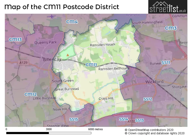
The CM11 Postcode shares a border with SS11 (WICKFORD, Runwell, Battlesbridge), SS12 (WICKFORD, North Benfleet), CM12 (BILLERICAY, Little Burstead), CM4 (INGATESTONE, Stock, Blackmore) and CM3 (South Woodham Ferrers, Danbury, Hatfield Peverel).
In the CM11 postcode district, the primary settlement with the highest count is Billericay, located in Essex. The most significant post town in this district is also Billericay, located in Essex.
For the district CM11, we have data on 2 postcode sectors. Here's a breakdown: The sector CM11 1, covers Billericay and Ramsden Heath and Downham in Essex. The sector CM11 2, covers Billericay and Crays Hill in Essex.

Map of the CM11 Postcode District
Explore the CM11 postcode district by using our free interactive map.
When it comes to local government, postal geography often disregards political borders. However, for a breakdown in the CM11 District: the district mostly encompasses the Basildon District (B) (370 postcodes), and finally, the Chelmsford District (B) area (78 postcodes).
Weather Forecast for CM11
Press Button to Show Forecast for Billericay
| Time Period | Icon | Description | Temperature | Rain Probability | Wind |
|---|---|---|---|---|---|
| 12:00 to 15:00 | Overcast | 9.0°C (feels like 7.0°C) | 12.00% | W 11 mph | |
| 15:00 to 18:00 | Overcast | 10.0°C (feels like 7.0°C) | 15.00% | NW 11 mph | |
| 18:00 to 21:00 | Cloudy | 8.0°C (feels like 6.0°C) | 12.00% | N 7 mph | |
| 21:00 to 00:00 | Cloudy | 6.0°C (feels like 5.0°C) | 8.00% | NE 4 mph |
Press Button to Show Forecast for Billericay
| Time Period | Icon | Description | Temperature | Rain Probability | Wind |
|---|---|---|---|---|---|
| 00:00 to 03:00 | Cloudy | 4.0°C (feels like 2.0°C) | 4.00% | NE 4 mph | |
| 03:00 to 06:00 | Cloudy | 3.0°C (feels like 1.0°C) | 4.00% | NNE 4 mph | |
| 06:00 to 09:00 | Cloudy | 4.0°C (feels like 2.0°C) | 4.00% | NE 4 mph | |
| 09:00 to 12:00 | Cloudy | 7.0°C (feels like 5.0°C) | 4.00% | ENE 7 mph | |
| 12:00 to 15:00 | Overcast | 9.0°C (feels like 7.0°C) | 9.00% | E 7 mph | |
| 15:00 to 18:00 | Overcast | 9.0°C (feels like 7.0°C) | 13.00% | E 7 mph | |
| 18:00 to 21:00 | Cloudy | 8.0°C (feels like 6.0°C) | 10.00% | E 9 mph | |
| 21:00 to 00:00 | Cloudy | 6.0°C (feels like 4.0°C) | 10.00% | E 7 mph |
Press Button to Show Forecast for Billericay
| Time Period | Icon | Description | Temperature | Rain Probability | Wind |
|---|---|---|---|---|---|
| 00:00 to 03:00 | Overcast | 6.0°C (feels like 3.0°C) | 16.00% | ENE 7 mph | |
| 03:00 to 06:00 | Light rain | 5.0°C (feels like 3.0°C) | 46.00% | ENE 7 mph | |
| 06:00 to 09:00 | Cloudy | 6.0°C (feels like 4.0°C) | 20.00% | ENE 9 mph | |
| 09:00 to 12:00 | Overcast | 9.0°C (feels like 6.0°C) | 20.00% | E 9 mph | |
| 12:00 to 15:00 | Cloudy | 11.0°C (feels like 9.0°C) | 16.00% | E 11 mph | |
| 15:00 to 18:00 | Cloudy | 12.0°C (feels like 10.0°C) | 19.00% | E 11 mph | |
| 18:00 to 21:00 | Light rain | 11.0°C (feels like 8.0°C) | 49.00% | E 9 mph | |
| 21:00 to 00:00 | Light rain | 9.0°C (feels like 7.0°C) | 51.00% | ENE 9 mph |
Press Button to Show Forecast for Billericay
| Time Period | Icon | Description | Temperature | Rain Probability | Wind |
|---|---|---|---|---|---|
| 00:00 to 03:00 | Light rain | 9.0°C (feels like 7.0°C) | 54.00% | E 9 mph | |
| 03:00 to 06:00 | Light rain | 9.0°C (feels like 7.0°C) | 53.00% | ESE 9 mph | |
| 06:00 to 09:00 | Light rain | 9.0°C (feels like 7.0°C) | 51.00% | SE 9 mph | |
| 09:00 to 12:00 | Heavy rain shower (day) | 10.0°C (feels like 8.0°C) | 55.00% | S 11 mph | |
| 12:00 to 15:00 | Light rain shower (day) | 12.0°C (feels like 10.0°C) | 42.00% | S 13 mph | |
| 15:00 to 18:00 | Heavy rain shower (day) | 13.0°C (feels like 11.0°C) | 53.00% | SSW 11 mph | |
| 18:00 to 21:00 | Light rain shower (day) | 12.0°C (feels like 10.0°C) | 35.00% | SSW 9 mph | |
| 21:00 to 00:00 | Partly cloudy (night) | 10.0°C (feels like 8.0°C) | 4.00% | SSW 9 mph |
Where is the CM11 Postcode District?
The postcode district for CM11 is located in Billericay. Billericay is situated near several nearby towns: Wickford to the east (2.83 miles away), Basildon to the south (3.35 miles away), Herongate to the southwest (5.20 miles away), Ingatestone to the northwest (6.24 miles away), and Benfleet to the southeast (6.59 miles away). Furthermore, Billericay is approximately 26.73 miles away from the center of London.
The district is within the post town of BILLERICAY.
The sector has postcodes within the nation of England.
The CM11 Postcode District is covers the following regions.
- Essex Thames Gateway - Essex - East of England
- Heart of Essex - Essex - East of England
| Postcode Sector | Delivery Office |
|---|---|
| CM11 1 | Billericay Delivery Office |
| CM11 2 | Billericay Delivery Office |
| C | M | 1 | 1 | - | X | X | X |
| C | M | 1 | 1 | Space | Numeric | Letter | Letter |
Current Monthly Rental Prices
| # Bedrooms | Min Price | Max Price | Avg Price |
|---|---|---|---|
| 1 | £850 | £925 | £888 |
| 2 | £1,800 | £1,800 | £1,800 |
| 3 | £1,995 | £1,995 | £1,995 |
| 4 | £2,000 | £2,395 | £2,248 |
| 6 | £10,000 | £10,000 | £10,000 |
Current House Prices
| # Bedrooms | Min Price | Max Price | Avg Price |
|---|---|---|---|
| 1 | £1,650,000 | £1,650,000 | £1,650,000 |
| 4 | £1,150,000 | £1,850,000 | £1,325,000 |
| 5 | £1,175,000 | £2,500,000 | £1,521,429 |
| 6 | £1,195,000 | £2,650,000 | £1,469,286 |
| 7 | £1,200,000 | £1,200,000 | £1,200,000 |
Estate Agents who Operate in the CM11 District
| Logo | Name | Brand Name | Address | Contact Number | Total Properties |
|---|---|---|---|---|---|
 | Billericay | Beresfords | 129 High Street, Billericay, CM12 9AH | 01277 674326 | 28 |
 | Billericay | Tyler Estates | 7 Grange Parade, Grange Road, Billericay, CM11 2RF. | 01277 674562 | 19 |
 | Billericay | Quirks | Estate House, 108a High Street, Billericay, CM12 9BY | 01277 674439 | 16 |
 | Billericay | The Property Specialists | 135 High Street Billericay CM12 9AB | 01277 674268 | 13 |
 | Billericay | ParaBar Estates | 106 High Street, Billericay, CM12 9BY | 01277 674377 | 13 |
| Type of Property | 2018 Average | 2018 Sales | 2017 Average | 2017 Sales | 2016 Average | 2016 Sales | 2015 Average | 2015 Sales |
|---|---|---|---|---|---|---|---|---|
| Detached | £718,942 | 102 | £667,732 | 133 | £705,617 | 122 | £629,639 | 142 |
| Semi-Detached | £393,467 | 128 | £397,993 | 122 | £367,006 | 123 | £323,135 | 139 |
| Terraced | £350,110 | 54 | £330,056 | 45 | £304,697 | 61 | £276,129 | 67 |
| Flats | £181,821 | 14 | £209,526 | 19 | £183,000 | 25 | £175,683 | 27 |