The CM13 postcode district is a postal district located in the CM Chelmsford postcode area with a population of 25,357 residents according to the 2021 England and Wales Census.
The area of the CM13 postcode district is 20.59 square miles which is 53.32 square kilometres or 13,176.56 acres.
Currently, the CM13 district has about 690 postcode units spread across 3 geographic postcode sectors.
Given that each sector allows for 400 unique postcode combinations, the district has a capacity of 1,200 postcodes. With 690 postcodes already in use, this leaves 510 units available.
The largest settlement in the CM13 postal code is Hutton followed by BRENTWOOD, and WEST HORNDON.
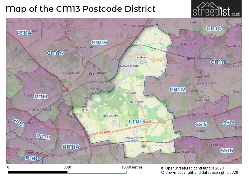
The CM13 Postcode shares a border with RM14 (UPMINSTER, Bulphan, NORTH OCKENDON), SS15 (BASILDON, Laindon, Southfields Business Park), CM12 (BILLERICAY, Little Burstead), CM14 (BRENTWOOD, Warley, Pilgrims Hatch), CM15 (Pilgrims Hatch, Shenfield, BRENTWOOD) and CM4 (INGATESTONE, Stock, Blackmore).
The primary settlement in the CM13 postcode district is Brentwood, located in the county of Essex, England. Other significant settlements in the area include Hutton, Mountnessing, Shenfield, Dunton, Great Warley, Herongate, Ingrave, Little Warley, and West Horndon.
For the district CM13, we have data on 3 postcode sectors. Here's a breakdown: The sector CM13 1, covers Hutton in Essex. The sector CM13 2, covers Hutton and Brentwood in Essex. The sector CM13 3, covers Great Warley and West Horndon and Ingrave and Herongate in Essex.

Map of the CM13 Postcode District
Explore the CM13 postcode district by using our free interactive map.
When it comes to local government, postal geography often disregards political borders. However, for a breakdown in the CM13 District: the district mostly encompasses the Brentwood District (B) (677 postcodes), followed by the Basildon District (B) area (14 postcodes), and finally, the Thurrock (B) area (7 postcodes).
Weather Forecast for CM13
Press Button to Show Forecast for Brentwood
| Time Period | Icon | Description | Temperature | Rain Probability | Wind |
|---|---|---|---|---|---|
| 18:00 to 21:00 | Cloudy | 8.0°C (feels like 5.0°C) | 12.00% | N 11 mph | |
| 21:00 to 00:00 | Cloudy | 6.0°C (feels like 3.0°C) | 4.00% | NNW 9 mph |
Press Button to Show Forecast for Brentwood
| Time Period | Icon | Description | Temperature | Rain Probability | Wind |
|---|---|---|---|---|---|
| 00:00 to 03:00 | Partly cloudy (night) | 4.0°C (feels like 1.0°C) | 0.00% | NW 9 mph | |
| 03:00 to 06:00 | Cloudy | 3.0°C (feels like -1.0°C) | 3.00% | NNW 11 mph | |
| 06:00 to 09:00 | Cloudy | 4.0°C (feels like 0.0°C) | 4.00% | NNW 11 mph | |
| 09:00 to 12:00 | Cloudy | 7.0°C (feels like 4.0°C) | 7.00% | NNW 13 mph | |
| 12:00 to 15:00 | Cloudy | 9.0°C (feels like 6.0°C) | 7.00% | NNW 13 mph | |
| 15:00 to 18:00 | Cloudy | 9.0°C (feels like 6.0°C) | 5.00% | NNW 13 mph | |
| 18:00 to 21:00 | Cloudy | 8.0°C (feels like 6.0°C) | 4.00% | N 9 mph | |
| 21:00 to 00:00 | Partly cloudy (night) | 5.0°C (feels like 3.0°C) | 1.00% | NNE 4 mph |
Press Button to Show Forecast for Brentwood
| Time Period | Icon | Description | Temperature | Rain Probability | Wind |
|---|---|---|---|---|---|
| 00:00 to 03:00 | Cloudy | 4.0°C (feels like 2.0°C) | 4.00% | SW 7 mph | |
| 03:00 to 06:00 | Cloudy | 4.0°C (feels like 1.0°C) | 4.00% | WSW 7 mph | |
| 06:00 to 09:00 | Cloudy | 5.0°C (feels like 2.0°C) | 5.00% | WSW 9 mph | |
| 09:00 to 12:00 | Cloudy | 8.0°C (feels like 5.0°C) | 7.00% | W 9 mph | |
| 12:00 to 15:00 | Overcast | 10.0°C (feels like 7.0°C) | 15.00% | WNW 11 mph | |
| 15:00 to 18:00 | Overcast | 10.0°C (feels like 8.0°C) | 17.00% | WNW 9 mph | |
| 18:00 to 21:00 | Cloudy | 9.0°C (feels like 7.0°C) | 13.00% | NW 7 mph | |
| 21:00 to 00:00 | Cloudy | 6.0°C (feels like 5.0°C) | 7.00% | NE 7 mph |
Press Button to Show Forecast for Brentwood
| Time Period | Icon | Description | Temperature | Rain Probability | Wind |
|---|---|---|---|---|---|
| 00:00 to 03:00 | Cloudy | 5.0°C (feels like 3.0°C) | 5.00% | NNE 7 mph | |
| 03:00 to 06:00 | Cloudy | 4.0°C (feels like 2.0°C) | 5.00% | NNE 7 mph | |
| 06:00 to 09:00 | Cloudy | 4.0°C (feels like 2.0°C) | 6.00% | NNE 7 mph | |
| 09:00 to 12:00 | Cloudy | 8.0°C (feels like 6.0°C) | 9.00% | ENE 7 mph | |
| 12:00 to 15:00 | Overcast | 10.0°C (feels like 8.0°C) | 15.00% | SE 9 mph | |
| 15:00 to 18:00 | Cloudy | 10.0°C (feels like 8.0°C) | 18.00% | ESE 9 mph | |
| 18:00 to 21:00 | Cloudy | 9.0°C (feels like 7.0°C) | 16.00% | ESE 9 mph | |
| 21:00 to 00:00 | Cloudy | 7.0°C (feels like 5.0°C) | 14.00% | ESE 9 mph |
Press Button to Show Forecast for Brentwood
| Time Period | Icon | Description | Temperature | Rain Probability | Wind |
|---|---|---|---|---|---|
| 00:00 to 03:00 | Cloudy | 7.0°C (feels like 4.0°C) | 20.00% | ESE 9 mph | |
| 03:00 to 06:00 | Cloudy | 6.0°C (feels like 4.0°C) | 17.00% | ESE 9 mph | |
| 06:00 to 09:00 | Overcast | 7.0°C (feels like 5.0°C) | 21.00% | ESE 9 mph | |
| 09:00 to 12:00 | Cloudy | 10.0°C (feels like 8.0°C) | 15.00% | SE 9 mph | |
| 12:00 to 15:00 | Light rain | 12.0°C (feels like 10.0°C) | 45.00% | SE 11 mph | |
| 15:00 to 18:00 | Light rain | 12.0°C (feels like 10.0°C) | 48.00% | SE 11 mph | |
| 18:00 to 21:00 | Light rain shower (day) | 11.0°C (feels like 9.0°C) | 32.00% | ESE 11 mph | |
| 21:00 to 00:00 | Cloudy | 10.0°C (feels like 7.0°C) | 12.00% | ESE 11 mph |
Where is the CM13 Postcode District?
The CM13 postcode district is located in Brentwood, a town in Essex. It is situated near several other towns: Herongate to the southeast, West Horndon to the south, Little Warley to the southwest, Warley to the west, Billericay to the northeast, and Pilgrims Hatch to the northwest. The distance to the center of London from CM13 is approximately 21.24 miles.
The district is within the post town of BRENTWOOD.
The sector has postcodes within the nation of England.
The CM13 Postcode District is covers the following regions.
- Heart of Essex - Essex - East of England
- Essex Thames Gateway - Essex - East of England
- Thurrock - Essex - East of England
- Barking & Dagenham and Havering - Outer London - East and North East - London
| Postcode Sector | Delivery Office |
|---|---|
| CM13 1 | Brentwood Delivery Office |
| CM13 2 | Brentwood Delivery Office |
| CM13 3 | Brentwood Delivery Office |
| C | M | 1 | 3 | - | X | X | X |
| C | M | 1 | 3 | Space | Numeric | Letter | Letter |
Current Monthly Rental Prices
| # Bedrooms | Min Price | Max Price | Avg Price |
|---|---|---|---|
| 1 | £1,000 | £1,400 | £1,313 |
| 2 | £1,575 | £2,000 | £1,765 |
| 3 | £1,350 | £4,000 | £2,133 |
| 4 | £2,700 | £2,700 | £2,700 |
| 5 | £3,500 | £4,250 | £3,875 |
Current House Prices
| # Bedrooms | Min Price | Max Price | Avg Price |
|---|---|---|---|
| £1,650,000 | £1,650,000 | £1,650,000 | |
| 4 | £1,600,000 | £4,000,000 | £2,399,167 |
| 5 | £1,795,000 | £3,350,000 | £2,340,000 |
| 6 | £1,895,000 | £4,650,000 | £3,282,500 |
| 7 | £1,599,995 | £1,599,995 | £1,599,995 |
Estate Agents who Operate in the CM13 District
| Logo | Name | Brand Name | Address | Contact Number | Total Properties |
|---|---|---|---|---|---|
 | Shenfield | Beresfords | 226 Hutton Road Shenfield Brentwood Essex CM15 8PA | 01277 674308 | 32 |
 | Shenfield | Meacock & Jones | 106 Hutton Road, Shenfield, Brentwood, CM15 8NQ | 01277 674865 | 19 |
 | Brentwood | Keith Ashton | 26 St. Thomas Road, Brentwood, CM14 4DB | 01277 674388 | 15 |
 | Shenfield | WN Properties | 148 Hutton Road, Shenfield, Brentwood, CM15 8NL. | 01270 433823 | 15 |
 | Brentwood | Bairstow Eves | 2 High Street, Brentwood, Essex, CM14 4AB | 01277 674238 | 14 |
| Type of Property | 2018 Average | 2018 Sales | 2017 Average | 2017 Sales | 2016 Average | 2016 Sales | 2015 Average | 2015 Sales |
|---|---|---|---|---|---|---|---|---|
| Detached | £1,028,764 | 127 | £869,521 | 131 | £871,020 | 122 | £732,121 | 143 |
| Semi-Detached | £454,214 | 125 | £454,040 | 140 | £424,336 | 133 | £362,452 | 143 |
| Terraced | £363,999 | 76 | £343,694 | 67 | £343,707 | 86 | £281,803 | 94 |
| Flats | £236,727 | 57 | £268,222 | 65 | £226,134 | 62 | £222,841 | 99 |