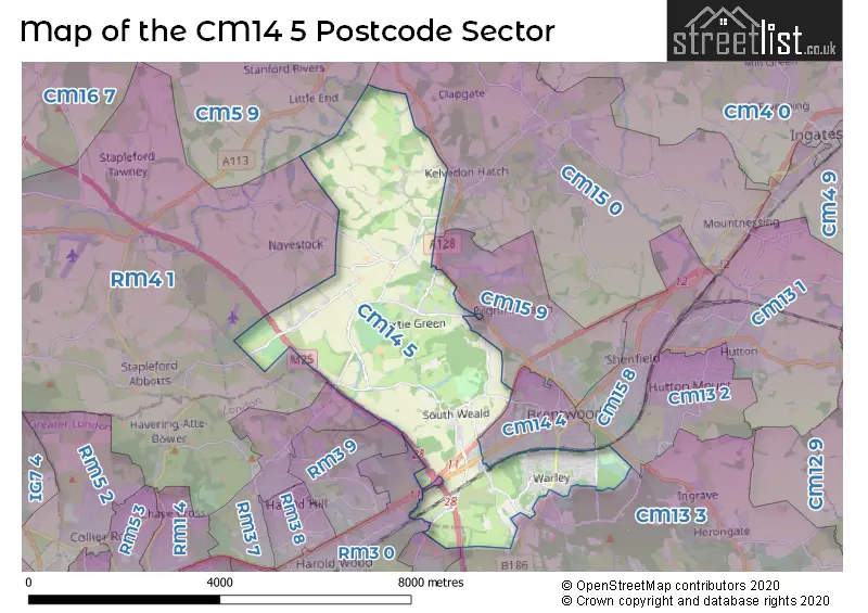
The CM14 5 postcode sector stands on the Essex and Greater London border.
Did you know? According to the 2021 Census, the CM14 5 postcode sector is home to a bustling 9,184 residents!
Given that each sector allows for 400 unique postcode combinations. Letters C, I, K, M, O and V are not allowed in the last two letters of a postcode. With 262 postcodes already in use, this leaves 138 units available.
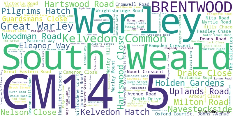
The largest settlement in the CM14 5 postal code is Warley followed by BRENTWOOD, and Pilgrims Hatch.
The CM14 5 Postcode shares a border with RM4 1 (LAMBOURNE , STAPLEFORD ABBOTTS , HAVERING-ATTE-BOWER ), RM3 9 (ROMFORD ), CM15 0 (Doddinghurst, Kelvedon Hatch, Mountnessing), CM5 9 (ONGAR, High Ongar, Stanford Rivers), RM3 0 (ROMFORD , HAROLD WOOD ), RM3 7 (ROMFORD , NOAK HILL ), RM14 1 (UPMINSTER), CM13 2 (Hutton, BRENTWOOD), CM13 3 (WEST HORNDON, GREAT WARLEY, WARLEY), CM14 4 (BRENTWOOD), CM15 8 (Shenfield, BRENTWOOD) and CM15 9 (Pilgrims Hatch, BRENTWOOD, Shenfield).
The sector is within the post town of BRENTWOOD.
CM14 5 is a postcode sector within the CM14 postcode district which is within the CM Chelmsford postcode area.
The Royal Mail delivery office for the CM14 5 postal sector is the Brentwood Delivery Office.
The area of the CM14 5 postcode sector is 10.33 square miles which is 26.75 square kilometres or 6,609.69 square acres.
The CM14 5 postcode sector is crossed by the A12 Major A road.
The CM14 5 postcode sector is crossed by the A1023 Major A road.
The CM14 5 postcode sector is crossed by the M25 motorway.
Waterways within the CM14 5 postcode sector include the River Ingrebourne.

Map of the CM14 5 Postcode Sector
Explore the CM14 5 postcode sector by using our free interactive map.
| C | M | 1 | 4 | - | 5 | X | X |
| C | M | 1 | 4 | Space | 5 | Letter | Letter |
Official List of Streets
Warley (69 Streets)
BRENTWOOD (18 Streets)
Kelvedon Common (3 Streets)
Pilgrims Hatch (9 Streets)
Kelvedon Hatch (7 Streets)
South Weald (7 Streets)
Great Warley (4 Streets)
Navestockside (3 Streets)
Unofficial Streets or Alternative Spellings
Great Warley
GREAT ROPERS LANE JASMINE CLOSE WARLEY HILL BARTON COURT BEACON HILL BEECHES SPINNEY BENTLEY CRICKET CLUB BIBI PLACE BRENTWOOD BYPASS BROOK STREET ROUNDABOUT CHESTNUT AVENUE CHURCH CLOSE DEANS COURT DUDBROOK ROAD LADYS HILL DYTCHLEYS LANE DYTCHLEYS ROAD FISHER COURT MAGNOLIA CRESCENT MASEFIELD COURT PARK LANE PENNY FIELDS PINE COURT PRINCES ROAD PUTWELL BRIDGE ROMAN ROAD SAINT PETERS ROAD SANDERS COURT SYCAMORE CLOSE THE BADGERS THE CHASE THORNDALES TURNER CLOSE TYSER GREEN VICARAGE LANE WARLEY WOODS CRESCENT WATER TOWER WAY WATLINGTON GARDENS WOODMAN ROAD CEMETERY WOODSIDE PLACEBRENTWOOD
BROOK ROAD KAVANAGHS ROAD LONDON ROAD SEVEN ARCHES ROAD WESTBOURNE DRIVEPilgrims Hatch
ORCHARD LANEROMFORD
CHEQUERS ROAD COLCHESTER ROADNavestock
HORSEMAN SIDE OLD ROADWeather Forecast for CM14 5
Press Button to Show Forecast for Brentwood
| Time Period | Icon | Description | Temperature | Rain Probability | Wind |
|---|---|---|---|---|---|
| 09:00 to 12:00 | Cloudy | 7.0°C (feels like 3.0°C) | 4.00% | N 13 mph | |
| 12:00 to 15:00 | Overcast | 9.0°C (feels like 6.0°C) | 6.00% | N 13 mph | |
| 15:00 to 18:00 | Cloudy | 10.0°C (feels like 7.0°C) | 7.00% | N 13 mph | |
| 18:00 to 21:00 | Cloudy | 8.0°C (feels like 5.0°C) | 3.00% | N 11 mph | |
| 21:00 to 00:00 | Partly cloudy (night) | 6.0°C (feels like 3.0°C) | 1.00% | N 7 mph |
Press Button to Show Forecast for Brentwood
| Time Period | Icon | Description | Temperature | Rain Probability | Wind |
|---|---|---|---|---|---|
| 00:00 to 03:00 | Partly cloudy (night) | 4.0°C (feels like 1.0°C) | 1.00% | NNW 7 mph | |
| 03:00 to 06:00 | Cloudy | 4.0°C (feels like 0.0°C) | 4.00% | NNW 9 mph | |
| 06:00 to 09:00 | Overcast | 4.0°C (feels like 1.0°C) | 9.00% | NNW 9 mph | |
| 09:00 to 12:00 | Overcast | 7.0°C (feels like 4.0°C) | 9.00% | NNE 11 mph | |
| 12:00 to 15:00 | Overcast | 9.0°C (feels like 6.0°C) | 9.00% | NNE 11 mph | |
| 15:00 to 18:00 | Overcast | 10.0°C (feels like 7.0°C) | 10.00% | NNE 11 mph | |
| 18:00 to 21:00 | Cloudy | 9.0°C (feels like 6.0°C) | 6.00% | NNE 11 mph | |
| 21:00 to 00:00 | Clear night | 6.0°C (feels like 3.0°C) | 2.00% | NNE 9 mph |
Press Button to Show Forecast for Brentwood
| Time Period | Icon | Description | Temperature | Rain Probability | Wind |
|---|---|---|---|---|---|
| 00:00 to 03:00 | Clear night | 4.0°C (feels like 1.0°C) | 1.00% | N 9 mph | |
| 03:00 to 06:00 | Partly cloudy (night) | 3.0°C (feels like 0.0°C) | 1.00% | N 9 mph | |
| 06:00 to 09:00 | Partly cloudy (day) | 4.0°C (feels like 1.0°C) | 2.00% | N 9 mph | |
| 09:00 to 12:00 | Cloudy | 8.0°C (feels like 6.0°C) | 6.00% | NNE 9 mph | |
| 12:00 to 15:00 | Overcast | 9.0°C (feels like 7.0°C) | 12.00% | N 7 mph | |
| 15:00 to 18:00 | Overcast | 9.0°C (feels like 7.0°C) | 16.00% | N 7 mph | |
| 18:00 to 21:00 | Overcast | 8.0°C (feels like 6.0°C) | 16.00% | N 7 mph | |
| 21:00 to 00:00 | Cloudy | 6.0°C (feels like 4.0°C) | 12.00% | NNE 4 mph |
Press Button to Show Forecast for Brentwood
| Time Period | Icon | Description | Temperature | Rain Probability | Wind |
|---|---|---|---|---|---|
| 00:00 to 03:00 | Cloudy | 5.0°C (feels like 2.0°C) | 10.00% | NE 7 mph | |
| 03:00 to 06:00 | Cloudy | 4.0°C (feels like 2.0°C) | 11.00% | NW 7 mph | |
| 06:00 to 09:00 | Cloudy | 5.0°C (feels like 2.0°C) | 11.00% | NNW 7 mph | |
| 09:00 to 12:00 | Cloudy | 8.0°C (feels like 6.0°C) | 9.00% | N 9 mph | |
| 12:00 to 15:00 | Overcast | 10.0°C (feels like 8.0°C) | 12.00% | N 9 mph | |
| 15:00 to 18:00 | Cloudy | 10.0°C (feels like 7.0°C) | 10.00% | NNE 11 mph | |
| 18:00 to 21:00 | Cloudy | 9.0°C (feels like 7.0°C) | 7.00% | NNE 9 mph | |
| 21:00 to 00:00 | Clear night | 6.0°C (feels like 4.0°C) | 8.00% | NNE 7 mph |
Schools and Places of Education Within the CM14 5 Postcode Sector
Holly Trees Primary School
Community school
Vaughan Williams Way, Brentwood, Essex, CM14 5RY
Head: Mrs Sarah Meacher
Ofsted Rating: Good
Inspection: 2023-05-24 (332 days ago)
Website: Visit Holly Trees Primary School Website
Phone: 01277212296
Number of Pupils: 414
St Peter's Church of England Voluntary Aided Primary School, South Weald
Voluntary aided school
Wigley Bush Lane, Brentwood, Essex, CM14 5QN
Head: Mr Iain Gunn
Ofsted Rating: Outstanding
Inspection: 2023-11-30 (142 days ago)
Website: Visit St Peter's Church of England Voluntary Aided Primary School, South Weald Website
Phone: 01277215577
Number of Pupils: 415
Warley Primary School
Community school
Chindits Lane, Brentwood, Essex, CM14 5LF
Head: Mrs Jennifer Evans
Ofsted Rating: Good
Inspection: 2023-02-03 (442 days ago)
Website: Visit Warley Primary School Website
Phone: 01277223008
Number of Pupils: 345
House Prices in the CM14 5 Postcode Sector
| Type of Property | 2018 Average | 2018 Sales | 2017 Average | 2017 Sales | 2016 Average | 2016 Sales | 2015 Average | 2015 Sales |
|---|---|---|---|---|---|---|---|---|
| Detached | £718,042 | 24 | £703,651 | 38 | £648,243 | 39 | £630,343 | 37 |
| Semi-Detached | £504,450 | 33 | £470,246 | 52 | £484,569 | 18 | £406,057 | 43 |
| Terraced | £407,758 | 43 | £425,327 | 58 | £394,844 | 45 | £337,011 | 55 |
| Flats | £314,778 | 61 | £329,895 | 69 | £296,840 | 86 | £269,081 | 99 |
Important Postcodes CM14 5 in the Postcode Sector
CM14 5HQ is the postcode for North East London Mental Health NHS Trust, Mascalls Park
CM14 5LF is the postcode for Warley Primary School, Chindits Lane, Warley, and NEW BUILDING, Warley Primary School, Chindits Lane
CM14 5LL is the postcode for Leverton Hall Secure Unit, Dark Lane, Leverton House Open Unit, Dark Lane, and Leverton Hall, Dark Lane
CM14 5QN is the postcode for St. Peters C of E Primary School, Wigley Bush Lane, St. Peters C of E Primary School, Wigley Bush Lane, South Weald, and MAIN BUILDING, St. Peters C of E Primary School, Wigley Bush Lane
CM14 5QS is the postcode for Essex County Council, Parks Office, Weald Road
CM14 5RY is the postcode for Holly Trees Primary School, Vaughan Williams Way
CM14 5WF is the postcode for Beechwood Surgery, Pastoral Way, Warley, and Beechwood Surgery, Pastoral Way
| The CM14 5 Sector is within these Local Authorities |
|
|---|---|
| The CM14 5 Sector is within these Counties |
|
| The CM14 5 Sector is within these Water Company Areas |
|