The CM15 postcode district is a postal district located in the CM Chelmsford postcode area with a population of 23,950 residents according to the 2021 England and Wales Census.
The area of the CM15 postcode district is 14.67 square miles which is 37.99 square kilometres or 9,387.25 acres.
Currently, the CM15 district has about 587 postcode units spread across 3 geographic postcode sectors.
Given that each sector allows for 400 unique postcode combinations, the district has a capacity of 1,200 postcodes. With 587 postcodes already in use, this leaves 613 units available.
The largest settlement in the CM15 postal code is Pilgrims Hatch followed by Shenfield, and BRENTWOOD.
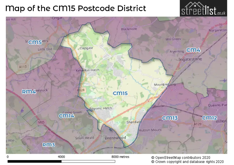
The CM15 Postcode shares a border with CM13 (Hutton, BRENTWOOD, WEST HORNDON), CM14 (BRENTWOOD, Warley, Pilgrims Hatch), CM4 (INGATESTONE, Stock, Blackmore) and CM5 (ONGAR, Fyfield, High Ongar).
The primary settlement in the CM15 postcode district is Brentwood, located in the county of Essex, in England. Other significant settlements in this district include Doddinghurst, Hook End, Kelvedon Hatch, Mountnessing, Pilgrims Hatch, Shenfield, Stondon Massey, and Wyatts Green. The most significant post town in this district is Brentwood.
For the district CM15, we have data on 3 postcode sectors. Here's a breakdown: The sector CM15 0, covers Doddinghurst and Kelvedon Hatch and Hook End and Mountnessing and Stondon Massey in Essex. The sector CM15 8, covers Shenfield and Brentwood in Essex. The sector CM15 9, covers Pilgrims Hatch and Brentwood in Essex.

Map of the CM15 Postcode District
Explore the CM15 postcode district by using our free interactive map.
When it comes to local government, postal geography often disregards political borders. However, for a breakdown in the CM15 District: the district mostly encompasses the Brentwood District (B) area with a total of 585 postcodes.
Weather Forecast for CM15
Press Button to Show Forecast for Brentwood
| Time Period | Icon | Description | Temperature | Rain Probability | Wind |
|---|---|---|---|---|---|
| 03:00 to 06:00 | Partly cloudy (night) | 3.0°C (feels like -1.0°C) | 0.00% | NNW 11 mph | |
| 06:00 to 09:00 | Cloudy | 3.0°C (feels like 0.0°C) | 3.00% | NNW 11 mph | |
| 09:00 to 12:00 | Cloudy | 7.0°C (feels like 3.0°C) | 4.00% | N 13 mph | |
| 12:00 to 15:00 | Overcast | 9.0°C (feels like 6.0°C) | 6.00% | N 13 mph | |
| 15:00 to 18:00 | Cloudy | 10.0°C (feels like 7.0°C) | 7.00% | N 13 mph | |
| 18:00 to 21:00 | Cloudy | 8.0°C (feels like 5.0°C) | 3.00% | N 11 mph | |
| 21:00 to 00:00 | Partly cloudy (night) | 6.0°C (feels like 3.0°C) | 1.00% | N 7 mph |
Press Button to Show Forecast for Brentwood
| Time Period | Icon | Description | Temperature | Rain Probability | Wind |
|---|---|---|---|---|---|
| 00:00 to 03:00 | Partly cloudy (night) | 4.0°C (feels like 1.0°C) | 1.00% | NNW 7 mph | |
| 03:00 to 06:00 | Cloudy | 4.0°C (feels like 0.0°C) | 4.00% | NNW 9 mph | |
| 06:00 to 09:00 | Overcast | 4.0°C (feels like 1.0°C) | 9.00% | NNW 9 mph | |
| 09:00 to 12:00 | Overcast | 7.0°C (feels like 4.0°C) | 9.00% | NNE 11 mph | |
| 12:00 to 15:00 | Overcast | 9.0°C (feels like 6.0°C) | 9.00% | NNE 11 mph | |
| 15:00 to 18:00 | Overcast | 10.0°C (feels like 7.0°C) | 10.00% | NNE 11 mph | |
| 18:00 to 21:00 | Cloudy | 9.0°C (feels like 6.0°C) | 6.00% | NNE 11 mph | |
| 21:00 to 00:00 | Clear night | 6.0°C (feels like 3.0°C) | 2.00% | NNE 9 mph |
Press Button to Show Forecast for Brentwood
| Time Period | Icon | Description | Temperature | Rain Probability | Wind |
|---|---|---|---|---|---|
| 00:00 to 03:00 | Clear night | 4.0°C (feels like 1.0°C) | 1.00% | N 9 mph | |
| 03:00 to 06:00 | Partly cloudy (night) | 3.0°C (feels like 0.0°C) | 1.00% | N 9 mph | |
| 06:00 to 09:00 | Partly cloudy (day) | 4.0°C (feels like 1.0°C) | 2.00% | N 9 mph | |
| 09:00 to 12:00 | Cloudy | 8.0°C (feels like 6.0°C) | 6.00% | NNE 9 mph | |
| 12:00 to 15:00 | Overcast | 9.0°C (feels like 7.0°C) | 12.00% | N 7 mph | |
| 15:00 to 18:00 | Overcast | 9.0°C (feels like 7.0°C) | 16.00% | N 7 mph | |
| 18:00 to 21:00 | Overcast | 8.0°C (feels like 6.0°C) | 16.00% | N 7 mph | |
| 21:00 to 00:00 | Cloudy | 6.0°C (feels like 4.0°C) | 12.00% | NNE 4 mph |
Press Button to Show Forecast for Brentwood
| Time Period | Icon | Description | Temperature | Rain Probability | Wind |
|---|---|---|---|---|---|
| 00:00 to 03:00 | Cloudy | 5.0°C (feels like 2.0°C) | 10.00% | NE 7 mph | |
| 03:00 to 06:00 | Cloudy | 4.0°C (feels like 2.0°C) | 11.00% | NW 7 mph | |
| 06:00 to 09:00 | Cloudy | 5.0°C (feels like 2.0°C) | 11.00% | NNW 7 mph | |
| 09:00 to 12:00 | Cloudy | 8.0°C (feels like 6.0°C) | 9.00% | N 9 mph | |
| 12:00 to 15:00 | Overcast | 10.0°C (feels like 8.0°C) | 12.00% | N 9 mph | |
| 15:00 to 18:00 | Cloudy | 10.0°C (feels like 7.0°C) | 10.00% | NNE 11 mph | |
| 18:00 to 21:00 | Cloudy | 9.0°C (feels like 7.0°C) | 7.00% | NNE 9 mph | |
| 21:00 to 00:00 | Clear night | 6.0°C (feels like 4.0°C) | 8.00% | NNE 7 mph |
Where is the CM15 Postcode District?
The postcode district for CM15 is located in Brentwood, which is a town in Essex. It is situated near several other towns, including Pilgrims Hatch to the southwest, Ingatestone to the northeast, Warley to the south, and Navestock to the west. Additionally, the postcode district is approximately 21.3 miles away from the center of London.
The district is within the post town of BRENTWOOD.
The sector has postcodes within the nation of England.
The CM15 Postcode District is covers the following regions.
- Heart of Essex - Essex - East of England
- West Essex - Essex - East of England
| Postcode Sector | Delivery Office |
|---|---|
| CM15 0 | Brentwood Delivery Office |
| CM15 8 | Brentwood Delivery Office |
| CM15 9 | Brentwood Delivery Office |
| C | M | 1 | 5 | - | X | X | X |
| C | M | 1 | 5 | Space | Numeric | Letter | Letter |
Current Monthly Rental Prices
| # Bedrooms | Min Price | Max Price | Avg Price |
|---|---|---|---|
| £850 | £850 | £850 | |
| 1 | £1,100 | £1,650 | £1,292 |
| 2 | £1,425 | £2,295 | £1,922 |
| 3 | £1,800 | £2,195 | £2,024 |
| 4 | £1,800 | £3,250 | £2,683 |
| 5 | £3,500 | £4,200 | £3,850 |
Current House Prices
| # Bedrooms | Min Price | Max Price | Avg Price |
|---|---|---|---|
| 3 | £1,035,000 | £1,100,000 | £1,067,500 |
| 4 | £1,095,000 | £1,750,000 | £1,255,000 |
| 5 | £1,100,000 | £2,350,000 | £1,642,857 |
| 6 | £1,000,000 | £1,950,000 | £1,475,000 |
| 8 | £1,400,000 | £1,400,000 | £1,400,000 |
Estate Agents who Operate in the CM15 District
| Logo | Name | Brand Name | Address | Contact Number | Total Properties |
|---|---|---|---|---|---|
 | Kelvedon Hatch | Keith Ashton | 38 Blackmore Road, Kelvedon Hatch, Brentwood, CM15 0AT | 01277 674395 | 28 |
 | at Brentwood | Beresfords | 77 - 79 High Street Brentwood CM14 4RR | 01277 674353 | 25 |
 | Brentwood | Balgores Hayes | 7 St. Thomas Road, Brentwood, CM14 4DB | 01277 674667 | 20 |
 | Brentwood | Keith Ashton | 26 St. Thomas Road, Brentwood, CM14 4DB | 01277 674388 | 19 |
 | Brentwood | Bairstow Eves | 2 High Street, Brentwood, Essex, CM14 4AB | 01277 674238 | 16 |
| Type of Property | 2018 Average | 2018 Sales | 2017 Average | 2017 Sales | 2016 Average | 2016 Sales | 2015 Average | 2015 Sales |
|---|---|---|---|---|---|---|---|---|
| Detached | £737,940 | 132 | £764,311 | 119 | £682,753 | 142 | £612,086 | 140 |
| Semi-Detached | £488,183 | 144 | £465,300 | 128 | £446,389 | 125 | £421,126 | 141 |
| Terraced | £363,269 | 52 | £364,127 | 52 | £335,696 | 56 | £314,510 | 49 |
| Flats | £279,632 | 79 | £277,618 | 82 | £242,859 | 64 | £216,914 | 90 |
Hotels within the Postcode Area
We found 1 hotels and guest houses within the CM15 postcode area
AdoniaPro Brentwood Apartment
Hutton Road 83b Viceroy Parade, Brentwood, brentwood, CM15 8JD.
View details