The CM15 0 postcode sector is within the county of Essex.
Did you know? According to the 2021 Census, the CM15 0 postcode sector is home to a bustling 8,863 residents!
Given that each sector allows for 400 unique postcode combinations. Letters C, I, K, M, O and V are not allowed in the last two letters of a postcode. With 229 postcodes already in use, this leaves 171 units available.
The largest settlement in the CM15 0 postal code is Doddinghurst followed by Kelvedon Hatch, and Mountnessing.
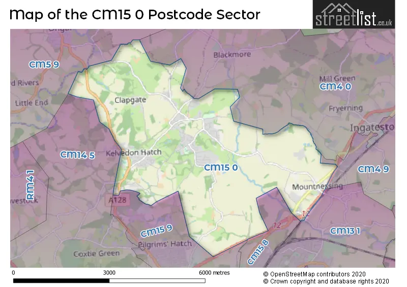
The CM15 0 Postcode shares a border with CM14 5 (Warley, BRENTWOOD, Pilgrims Hatch), CM4 0 (INGATESTONE, Blackmore, Margaretting), CM4 9 (Stock, INGATESTONE, Margaretting), CM5 9 (ONGAR, High Ongar, Stanford Rivers), CM13 1 (Hutton, Mountnessing), CM15 8 (Shenfield, BRENTWOOD) and CM15 9 (Pilgrims Hatch, BRENTWOOD, Shenfield).
The sector is within the post town of BRENTWOOD.
CM15 0 is a postcode sector within the CM15 postcode district which is within the CM Chelmsford postcode area.
The Royal Mail delivery office for the CM15 0 postal sector is the Brentwood Delivery Office.
The area of the CM15 0 postcode sector is 10.25 square miles which is 26.55 square kilometres or 6,559.64 square acres.
The CM15 0 postcode sector is crossed by the A12 Major A road.
Waterways within the CM15 0 postcode sector include the River Wid.

Map of the CM15 0 Postcode Sector
Explore the CM15 0 postcode sector by using our free interactive map.
| C | M | 1 | 5 | - | 0 | X | X |
| C | M | 1 | 5 | Space | 0 | Letter | Letter |
Official List of Streets
Doddinghurst (32 Streets)
Kelvedon Hatch (31 Streets)
Hook End (19 Streets)
Stondon Massey (7 Streets)
Mountnessing (16 Streets)
Wyatts Green (6 Streets)
Shenfield (2 Streets)
Unofficial Streets or Alternative Spellings
Doddinghurst
AARON PLACEBlackmore
BLACKMORE ROAD HAY GREEN LANE INGATESTONE ROAD MOUNTNESSING ROAD NINE ASHES ROADPilgrims Hatch
DAYS LANEKelvedon Hatch
CROWN ROAD GREEN LANE KELVEDON HALL LANEFryerning
BLACKMORE ROADONGAR
BRENTWOOD ROADWeather Forecast for CM15 0
Press Button to Show Forecast for Brentwood
| Time Period | Icon | Description | Temperature | Rain Probability | Wind |
|---|---|---|---|---|---|
| 12:00 to 15:00 | Overcast | 9.0°C (feels like 7.0°C) | 13.00% | W 11 mph | |
| 15:00 to 18:00 | Cloudy | 10.0°C (feels like 7.0°C) | 14.00% | NW 11 mph | |
| 18:00 to 21:00 | Cloudy | 8.0°C (feels like 6.0°C) | 11.00% | N 7 mph | |
| 21:00 to 00:00 | Cloudy | 6.0°C (feels like 4.0°C) | 10.00% | ENE 4 mph |
Press Button to Show Forecast for Brentwood
| Time Period | Icon | Description | Temperature | Rain Probability | Wind |
|---|---|---|---|---|---|
| 00:00 to 03:00 | Cloudy | 4.0°C (feels like 2.0°C) | 4.00% | NE 7 mph | |
| 03:00 to 06:00 | Cloudy | 3.0°C (feels like 1.0°C) | 4.00% | NE 4 mph | |
| 06:00 to 09:00 | Cloudy | 4.0°C (feels like 1.0°C) | 4.00% | NE 7 mph | |
| 09:00 to 12:00 | Cloudy | 7.0°C (feels like 5.0°C) | 4.00% | ENE 7 mph | |
| 12:00 to 15:00 | Overcast | 9.0°C (feels like 7.0°C) | 9.00% | E 7 mph | |
| 15:00 to 18:00 | Overcast | 9.0°C (feels like 7.0°C) | 13.00% | E 9 mph | |
| 18:00 to 21:00 | Cloudy | 8.0°C (feels like 6.0°C) | 10.00% | E 9 mph | |
| 21:00 to 00:00 | Cloudy | 6.0°C (feels like 4.0°C) | 10.00% | E 9 mph |
Press Button to Show Forecast for Brentwood
| Time Period | Icon | Description | Temperature | Rain Probability | Wind |
|---|---|---|---|---|---|
| 00:00 to 03:00 | Cloudy | 6.0°C (feels like 3.0°C) | 13.00% | ENE 9 mph | |
| 03:00 to 06:00 | Cloudy | 5.0°C (feels like 2.0°C) | 17.00% | ENE 9 mph | |
| 06:00 to 09:00 | Cloudy | 6.0°C (feels like 3.0°C) | 20.00% | ENE 9 mph | |
| 09:00 to 12:00 | Cloudy | 9.0°C (feels like 6.0°C) | 20.00% | E 11 mph | |
| 12:00 to 15:00 | Cloudy | 11.0°C (feels like 9.0°C) | 16.00% | E 11 mph | |
| 15:00 to 18:00 | Cloudy | 12.0°C (feels like 9.0°C) | 19.00% | E 11 mph | |
| 18:00 to 21:00 | Light rain | 10.0°C (feels like 8.0°C) | 49.00% | E 11 mph | |
| 21:00 to 00:00 | Light rain | 9.0°C (feels like 7.0°C) | 51.00% | ENE 11 mph |
Press Button to Show Forecast for Brentwood
| Time Period | Icon | Description | Temperature | Rain Probability | Wind |
|---|---|---|---|---|---|
| 00:00 to 03:00 | Light rain | 9.0°C (feels like 6.0°C) | 54.00% | E 11 mph | |
| 03:00 to 06:00 | Light rain shower (night) | 9.0°C (feels like 6.0°C) | 41.00% | ESE 11 mph | |
| 06:00 to 09:00 | Light rain | 9.0°C (feels like 7.0°C) | 51.00% | SE 11 mph | |
| 09:00 to 12:00 | Heavy rain shower (day) | 10.0°C (feels like 8.0°C) | 59.00% | S 13 mph | |
| 12:00 to 15:00 | Heavy rain shower (day) | 12.0°C (feels like 10.0°C) | 61.00% | S 13 mph | |
| 15:00 to 18:00 | Heavy rain shower (day) | 13.0°C (feels like 11.0°C) | 53.00% | SSW 13 mph | |
| 18:00 to 21:00 | Light rain shower (day) | 12.0°C (feels like 10.0°C) | 35.00% | SSW 11 mph | |
| 21:00 to 00:00 | Partly cloudy (night) | 9.0°C (feels like 7.0°C) | 4.00% | SSW 11 mph |
Schools and Places of Education Within the CM15 0 Postcode Sector
Doddinghurst Church of England Junior School
Academy converter
Church Lane, Brentwood, Essex, CM15 0NJ
Head: Mr Russell Davies
Ofsted Rating: Good
Inspection: 2023-10-18 (190 days ago)
Website: Visit Doddinghurst Church of England Junior School Website
Phone: 01277821064
Number of Pupils: 212
Doddinghurst Infant School
Community school
Church Lane, Brentwood, Essex, CM15 0NJ
Head: Mrs Ingrid Nicholson
Ofsted Rating: Good
Inspection: 2022-11-30 (512 days ago)
Website: Visit Doddinghurst Infant School Website
Phone: 01277822721
Number of Pupils: 129
Mountnessing Church of England Primary School
Academy converter
279 Roman Road, Brentwood, Essex, CM15 0UH
Head: Mrs Holly Obank
Ofsted Rating: Good
Inspection: 2022-09-15 (588 days ago)
Website: Visit Mountnessing Church of England Primary School Website
Phone: 01277353160
Number of Pupils: 138
House Prices in the CM15 0 Postcode Sector
| Type of Property | 2018 Average | 2018 Sales | 2017 Average | 2017 Sales | 2016 Average | 2016 Sales | 2015 Average | 2015 Sales |
|---|---|---|---|---|---|---|---|---|
| Detached | £591,228 | 72 | £666,814 | 62 | £546,569 | 73 | £540,740 | 70 |
| Semi-Detached | £449,953 | 55 | £423,609 | 41 | £415,727 | 37 | £385,224 | 41 |
| Terraced | £376,299 | 20 | £376,947 | 17 | £332,632 | 19 | £309,556 | 18 |
| Flats | £309,999 | 9 | £186,250 | 3 | £260,000 | 1 | £115,000 | 2 |
Important Postcodes CM15 0 in the Postcode Sector
CM15 0HU is the postcode for Deal Tree Health Centre, Blackmore Road
CM15 0NJ is the postcode for MAIN BUILDING, Doddinghurst C of E Junior School, Church Lane, DODDINGHURST C OF E JUNIOR SCHOOL, CHURCH LANE, DODDINGHURST, Doddinghurst Infant School, Church Lane, and Doddinghurst Infant School, Church Lane, Doddinghurst
| The CM15 0 Sector is within these Local Authorities |
|
|---|---|
| The CM15 0 Sector is within these Counties |
|
| The CM15 0 Sector is within these Water Company Areas |
|