The CO10 5 postcode sector is within the county of Suffolk.
Did you know? According to the 2021 Census, the CO10 5 postcode sector is home to a bustling 2,694 residents!
Given that each sector allows for 400 unique postcode combinations. Letters C, I, K, M, O and V are not allowed in the last two letters of a postcode. With 121 postcodes already in use, this leaves 279 units available.
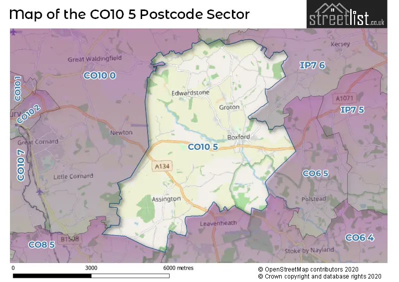
The largest settlement in the CO10 5 postal code is Boxford followed by Assington, and Edwardstone.
The CO10 5 Postcode shares a border with CO8 5 (BURES, Mount Bures, Alphamstone), CO10 0 (Great Cornard, Acton, Great Waldingfield), IP7 6 (Hadleigh, Elmsett, Kersey), IP7 7 (Bildeston, Hitcham, Wattisham Airfield), CO6 4 (Great Horkesley, Nayland, Leavenheath) and CO6 5 (Polstead, Polstead Heath).
The sector is within the post town of SUDBURY.
CO10 5 is a postcode sector within the CO10 postcode district which is within the CO Colchester postcode area.
The Royal Mail delivery office for the CO10 5 postal sector is the Colchester Delivery Office and Boxford Scale Payment Delivery Office.
The area of the CO10 5 postcode sector is 13.75 square miles which is 35.60 square kilometres or 8,797.32 square acres.
Waterways within the CO10 5 postcode sector include the River Box.

Map of the CO10 5 Postcode Sector
Explore the CO10 5 postcode sector by using our free interactive map.
| C | O | 1 | 0 | - | 5 | X | X |
| C | O | 1 | 0 | Space | 5 | Letter | Letter |
Official List of Streets
Boxford (36 Streets)
Assington (19 Streets)
Groton (14 Streets)
Unofficial Streets or Alternative Spellings
Leavenheath
HIGH ROAD STOKE ROADMilden
BOXFORD ROADStoke By Nayland
SUDBURY ROADNewton
ASSINGTON ROADBURES
DORKING TYEWeather Forecast for CO10 5
Press Button to Show Forecast for Sudbury
| Time Period | Icon | Description | Temperature | Rain Probability | Wind |
|---|---|---|---|---|---|
| 03:00 to 06:00 | Cloudy | 4.0°C (feels like 0.0°C) | 3.00% | NW 11 mph | |
| 06:00 to 09:00 | Cloudy | 4.0°C (feels like 0.0°C) | 4.00% | NW 11 mph | |
| 09:00 to 12:00 | Overcast | 7.0°C (feels like 3.0°C) | 8.00% | NNW 13 mph | |
| 12:00 to 15:00 | Cloudy | 9.0°C (feels like 6.0°C) | 5.00% | NNW 16 mph | |
| 15:00 to 18:00 | Cloudy | 9.0°C (feels like 6.0°C) | 4.00% | N 16 mph | |
| 18:00 to 21:00 | Partly cloudy (day) | 8.0°C (feels like 5.0°C) | 1.00% | N 11 mph | |
| 21:00 to 00:00 | Partly cloudy (night) | 5.0°C (feels like 3.0°C) | 1.00% | N 7 mph |
Press Button to Show Forecast for Sudbury
| Time Period | Icon | Description | Temperature | Rain Probability | Wind |
|---|---|---|---|---|---|
| 00:00 to 03:00 | Cloudy | 4.0°C (feels like 2.0°C) | 4.00% | NNW 7 mph | |
| 03:00 to 06:00 | Overcast | 4.0°C (feels like 1.0°C) | 7.00% | NNW 7 mph | |
| 06:00 to 09:00 | Overcast | 5.0°C (feels like 2.0°C) | 8.00% | NNW 7 mph | |
| 09:00 to 12:00 | Overcast | 8.0°C (feels like 4.0°C) | 10.00% | N 13 mph | |
| 12:00 to 15:00 | Overcast | 9.0°C (feels like 7.0°C) | 10.00% | NNE 13 mph | |
| 15:00 to 18:00 | Cloudy | 10.0°C (feels like 7.0°C) | 6.00% | NNE 11 mph | |
| 18:00 to 21:00 | Partly cloudy (day) | 8.0°C (feels like 6.0°C) | 3.00% | NNE 11 mph | |
| 21:00 to 00:00 | Clear night | 6.0°C (feels like 3.0°C) | 2.00% | NNE 7 mph |
Press Button to Show Forecast for Sudbury
| Time Period | Icon | Description | Temperature | Rain Probability | Wind |
|---|---|---|---|---|---|
| 00:00 to 03:00 | Clear night | 4.0°C (feels like 2.0°C) | 1.00% | N 7 mph | |
| 03:00 to 06:00 | Clear night | 3.0°C (feels like 1.0°C) | 2.00% | N 7 mph | |
| 06:00 to 09:00 | Partly cloudy (day) | 4.0°C (feels like 2.0°C) | 2.00% | N 7 mph | |
| 09:00 to 12:00 | Cloudy | 8.0°C (feels like 6.0°C) | 7.00% | N 9 mph | |
| 12:00 to 15:00 | Overcast | 9.0°C (feels like 7.0°C) | 14.00% | N 9 mph | |
| 15:00 to 18:00 | Overcast | 9.0°C (feels like 7.0°C) | 18.00% | N 7 mph | |
| 18:00 to 21:00 | Light rain | 8.0°C (feels like 6.0°C) | 43.00% | N 7 mph | |
| 21:00 to 00:00 | Cloudy | 6.0°C (feels like 4.0°C) | 12.00% | ENE 4 mph |
Press Button to Show Forecast for Sudbury
| Time Period | Icon | Description | Temperature | Rain Probability | Wind |
|---|---|---|---|---|---|
| 00:00 to 03:00 | Partly cloudy (night) | 4.0°C (feels like 2.0°C) | 7.00% | NW 4 mph | |
| 03:00 to 06:00 | Partly cloudy (night) | 4.0°C (feels like 2.0°C) | 8.00% | NW 4 mph | |
| 06:00 to 09:00 | Light rain | 5.0°C (feels like 3.0°C) | 40.00% | NNW 4 mph | |
| 09:00 to 12:00 | Light rain | 8.0°C (feels like 6.0°C) | 39.00% | NNE 7 mph | |
| 12:00 to 15:00 | Light rain | 10.0°C (feels like 8.0°C) | 42.00% | NNE 9 mph | |
| 15:00 to 18:00 | Overcast | 10.0°C (feels like 8.0°C) | 19.00% | NNE 9 mph | |
| 18:00 to 21:00 | Cloudy | 9.0°C (feels like 7.0°C) | 6.00% | NNE 9 mph | |
| 21:00 to 00:00 | Overcast | 6.0°C (feels like 4.0°C) | 8.00% | N 7 mph |
Schools and Places of Education Within the CO10 5 Postcode Sector
Boxford Church of England Voluntary Controlled Primary School
Voluntary controlled school
Stone Street Road, Sudbury, Suffolk, CO10 5NP
Head: Mrs Emma Lea
Ofsted Rating: Outstanding
Inspection: 2012-04-25 (4378 days ago)
Website: Visit Boxford Church of England Voluntary Controlled Primary School Website
Phone: 01787210332
Number of Pupils: 183
The Ryes College
Other independent special school
Pump Farm, Sudbury, Suffolk, CO10 5NA
Head: Mr Daniel Lawrence
Ofsted Rating: Good
Inspection: 2023-03-10 (407 days ago)
Website: Visit The Ryes College Website
Phone: 01787228344
Number of Pupils: 23
House Prices in the CO10 5 Postcode Sector
| Type of Property | 2018 Average | 2018 Sales | 2017 Average | 2017 Sales | 2016 Average | 2016 Sales | 2015 Average | 2015 Sales |
|---|---|---|---|---|---|---|---|---|
| Detached | £575,388 | 24 | £498,973 | 21 | £481,058 | 26 | £468,222 | 18 |
| Semi-Detached | £278,481 | 9 | £239,375 | 4 | £269,481 | 13 | £256,556 | 7 |
| Terraced | £282,700 | 5 | £303,050 | 10 | £335,308 | 13 | £253,050 | 10 |
| Flats | £110,000 | 1 | £119,625 | 2 | £0 | 0 | £0 | 0 |
Important Postcodes CO10 5 in the Postcode Sector
CO10 5NP is the postcode for Boxford Primary School, Stone Street Road, and Boxford Primary School, Stone Street Road, Boxford
| The CO10 5 Sector is within these Local Authorities |
|
|---|---|
| The CO10 5 Sector is within these Counties |
|
| The CO10 5 Sector is within these Water Company Areas |
|