The CO12 postcode district is a postal district located in the CO Colchester postcode area with a population of 23,460 residents according to the 2021 England and Wales Census.
The area of the CO12 postcode district is 17.23 square miles which is 44.63 square kilometres or 11,028.09 acres.
Currently, the CO12 district has about 624 postcode units spread across 3 geographic postcode sectors.
Given that each sector allows for 400 unique postcode combinations, the district has a capacity of 1,200 postcodes. With 624 postcodes already in use, this leaves 576 units available.
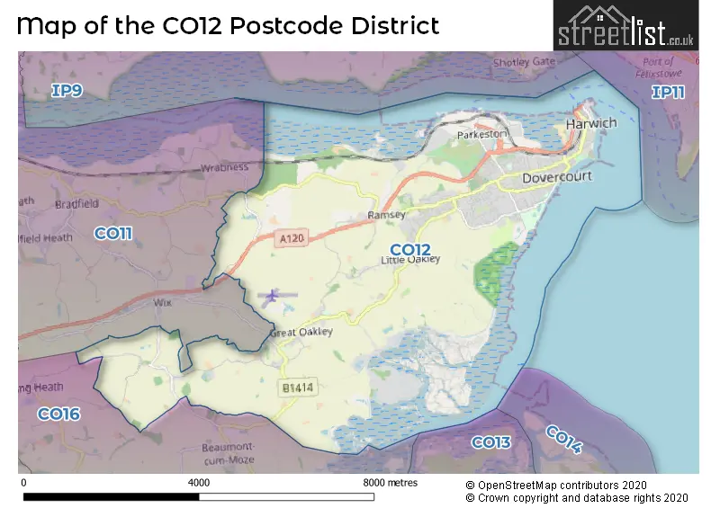
The largest settlement in the CO12 postal code is HARWICH followed by Dovercourt, and Ramsey.
The postcode area has a boundary with Harwich Harbour and Hamford Water and The North Sea.
The CO12 Postcode shares a border with CO11 (Lawford, Mistley, Brantham) and CO16 (CLACTON-ON-SEA, St. Osyth, Little Clacton).
The primary settlement in the CO12 postcode district is Harwich, located in the county of Essex in England. Other significant settlements in the district include Dovercourt, Parkeston, Ramsey, Great Oakley, Little Oakley, and Stones Green. The post town for this district is Harwich.
For the district CO12, we have data on 4 postcode sectors. Here's a breakdown: The sector CO12 3, covers Harwich in Essex. The sector CO12 4, covers Harwich in Essex. The sector CO12 5, covers Ramsey and Great Oakley and Little Oakley and Harwich in Essex. The sector CO12 9 is non-geographic. It's often designated for PO Boxes, large organisations, or special services.


Map of the CO12 Postcode District
Explore the CO12 postcode district by using our free interactive map.
When it comes to local government, postal geography often disregards political borders. However, for a breakdown in the CO12 District: the district mostly encompasses the Tendring District area with a total of 635 postcodes.
Weather Forecast for CO12
Press Button to Show Forecast for Harwich
| Time Period | Icon | Description | Temperature | Rain Probability | Wind |
|---|---|---|---|---|---|
| 12:00 to 15:00 | Cloudy | 9.0°C (feels like 6.0°C) | 13.00% | WNW 13 mph | |
| 15:00 to 18:00 | Light rain shower (day) | 8.0°C (feels like 5.0°C) | 32.00% | NNW 11 mph | |
| 18:00 to 21:00 | Cloudy | 7.0°C (feels like 6.0°C) | 8.00% | N 7 mph | |
| 21:00 to 00:00 | Clear night | 6.0°C (feels like 4.0°C) | 2.00% | N 7 mph |
Press Button to Show Forecast for Harwich
| Time Period | Icon | Description | Temperature | Rain Probability | Wind |
|---|---|---|---|---|---|
| 00:00 to 03:00 | Clear night | 4.0°C (feels like 1.0°C) | 1.00% | N 7 mph | |
| 03:00 to 06:00 | Clear night | 3.0°C (feels like 0.0°C) | 0.00% | N 7 mph | |
| 06:00 to 09:00 | Partly cloudy (day) | 4.0°C (feels like 2.0°C) | 1.00% | N 7 mph | |
| 09:00 to 12:00 | Partly cloudy (day) | 8.0°C (feels like 6.0°C) | 2.00% | ENE 7 mph | |
| 12:00 to 15:00 | Overcast | 9.0°C (feels like 7.0°C) | 10.00% | ESE 9 mph | |
| 15:00 to 18:00 | Overcast | 9.0°C (feels like 7.0°C) | 11.00% | ESE 9 mph | |
| 18:00 to 21:00 | Cloudy | 9.0°C (feels like 6.0°C) | 8.00% | E 9 mph | |
| 21:00 to 00:00 | Cloudy | 8.0°C (feels like 5.0°C) | 9.00% | E 11 mph |
Press Button to Show Forecast for Harwich
| Time Period | Icon | Description | Temperature | Rain Probability | Wind |
|---|---|---|---|---|---|
| 00:00 to 03:00 | Cloudy | 8.0°C (feels like 5.0°C) | 12.00% | E 11 mph | |
| 03:00 to 06:00 | Light rain | 8.0°C (feels like 5.0°C) | 45.00% | ENE 11 mph | |
| 06:00 to 09:00 | Light rain | 8.0°C (feels like 5.0°C) | 45.00% | ENE 11 mph | |
| 09:00 to 12:00 | Cloudy | 10.0°C (feels like 7.0°C) | 14.00% | E 11 mph | |
| 12:00 to 15:00 | Cloudy | 11.0°C (feels like 9.0°C) | 15.00% | ESE 11 mph | |
| 15:00 to 18:00 | Cloudy | 12.0°C (feels like 9.0°C) | 11.00% | E 11 mph | |
| 18:00 to 21:00 | Cloudy | 11.0°C (feels like 8.0°C) | 19.00% | ENE 13 mph | |
| 21:00 to 00:00 | Light rain | 10.0°C (feels like 8.0°C) | 50.00% | E 13 mph |
Press Button to Show Forecast for Harwich
| Time Period | Icon | Description | Temperature | Rain Probability | Wind |
|---|---|---|---|---|---|
| 00:00 to 03:00 | Light rain | 11.0°C (feels like 8.0°C) | 52.00% | E 13 mph | |
| 03:00 to 06:00 | Heavy rain | 10.0°C (feels like 8.0°C) | 73.00% | ESE 13 mph | |
| 06:00 to 09:00 | Light rain | 10.0°C (feels like 8.0°C) | 54.00% | SE 16 mph | |
| 09:00 to 12:00 | Light rain shower (day) | 11.0°C (feels like 8.0°C) | 39.00% | SSE 18 mph | |
| 12:00 to 15:00 | Light rain shower (day) | 12.0°C (feels like 9.0°C) | 38.00% | S 18 mph | |
| 15:00 to 18:00 | Light rain shower (day) | 13.0°C (feels like 10.0°C) | 37.00% | SSW 16 mph | |
| 18:00 to 21:00 | Light rain shower (day) | 12.0°C (feels like 10.0°C) | 33.00% | S 13 mph | |
| 21:00 to 00:00 | Clear night | 10.0°C (feels like 8.0°C) | 5.00% | SSW 11 mph |
Where is the CO12 Postcode District?
The postcode district CO12 is located in Harwich, a town in Essex. Harwich is surrounded by various nearby towns, including Walton on the Naze to the Southeast, Manningtree to the West, Frinton-on-Sea to the South, Felixstowe to the Northeast, Clacton-on-Sea to the Southwest, and Ipswich to the North. Harwich is located approximately 63.98 miles away to the center of London.
The district is within the post town of HARWICH.
The sector has postcodes within the nation of England.
The CO12 Postcode District is in the Essex Haven Gateway region of Essex within the East of England.
| Postcode Sector | Delivery Office |
|---|---|
| CO12 3 | Harwich Delivery Office |
| CO12 4 | Harwich Delivery Office |
| CO12 5 | Harwich Delivery Office |
| C | O | 1 | 2 | - | X | X | X |
| C | O | 1 | 2 | Space | Numeric | Letter | Letter |
Tourist Attractions within the Postcode Area
We found 4 visitor attractions within the CO12 postcode area
| Harwich Redoubt Fort |
|---|
| Historic Properties |
| Historic Monument / Archaeological Site |
| View Harwich Redoubt Fort on Google Maps |
| Harwich Lifeboat Museum |
| Visitor Centres |
| Heritage / Visitor Centre |
| View Harwich Lifeboat Museum on Google Maps |
| Radar Tower (Beacon Hill Fort) |
| Historic Properties |
| Historic Monument / Archaeological Site |
| View Radar Tower (Beacon Hill Fort) on Google Maps |
| Harwich Maritime Museum |
| Visitor Centres |
| Heritage / Visitor Centre |
| View Harwich Maritime Museum on Google Maps |
Current Monthly Rental Prices
| # Bedrooms | Min Price | Max Price | Avg Price |
|---|---|---|---|
| 1 | £550 | £895 | £674 |
| 2 | £575 | £1,000 | £792 |
| 3 | £900 | £900 | £900 |
| 4 | £2,250 | £2,500 | £2,375 |
Current House Prices
| # Bedrooms | Min Price | Max Price | Avg Price |
|---|---|---|---|
| 3 | £500,000 | £500,000 | £500,000 |
| 4 | £485,000 | £1,200,000 | £674,583 |
| 5 | £495,000 | £800,000 | £615,556 |
| 6 | £525,000 | £650,000 | £587,500 |
| 8 | £600,000 | £600,000 | £600,000 |
Estate Agents who Operate in the CO12 District
| Logo | Name | Brand Name | Address | Contact Number | Total Properties |
|---|---|---|---|---|---|
 | Harwich | William H. Brown | 280-282 High Street Dovercourt Harwich CO12 3PD | 01255 442113 | 60 |
 | Harwich | Harwich Village Homes | Tower House, 300 Main Road, Harwich, CO12 3PJ | 01255 442065 | 50 |
 | Harwich | Lamb & Co | 286 High Street Dovercourt Harwich CO12 3PD | 01255 442505 | 33 |
 | Harwich | Reid Residential | 6 Central House, Harwich, Essex, CO12 3PT | 01255 442094 | 28 |
 | Harwich | haart | 1 Steele House, Harwich, Essex, CO12 3PN | 01255 441760 | 15 |
| Type of Property | 2018 Average | 2018 Sales | 2017 Average | 2017 Sales | 2016 Average | 2016 Sales | 2015 Average | 2015 Sales |
|---|---|---|---|---|---|---|---|---|
| Detached | £293,122 | 123 | £277,556 | 142 | £243,419 | 133 | £245,445 | 113 |
| Semi-Detached | £201,780 | 109 | £189,702 | 139 | £174,785 | 127 | £160,737 | 123 |
| Terraced | £162,805 | 132 | £157,175 | 146 | £141,584 | 166 | £128,948 | 163 |
| Flats | £122,135 | 72 | £125,334 | 61 | £105,429 | 81 | £99,821 | 46 |