The CO2 9 postcode sector is within the county of Essex.
Did you know? According to the 2021 Census, the CO2 9 postcode sector is home to a bustling 10,204 residents!
Given that each sector allows for 400 unique postcode combinations. Letters C, I, K, M, O and V are not allowed in the last two letters of a postcode. With 215 postcodes already in use, this leaves 185 units available.
The CO2 9 postal code covers the settlement of COLCHESTER.
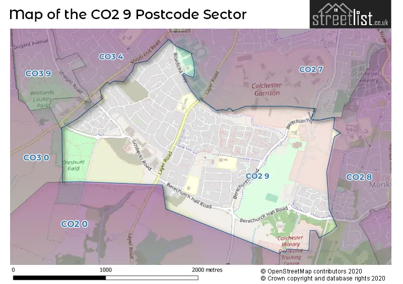
The CO2 9 Postcode shares a border with CO2 0 (Layer-de-la-Haye, COLCHESTER, Birch), CO2 8 (COLCHESTER), CO3 0 (Stanway), CO3 4 (COLCHESTER) and CO2 7 (COLCHESTER).
The sector is within the post town of COLCHESTER.
CO2 9 is a postcode sector within the CO2 postcode district which is within the CO Colchester postcode area.
The Royal Mail delivery office for the CO2 9 postal sector is the Colchester Delivery Office.
The area of the CO2 9 postcode sector is 1.48 square miles which is 3.84 square kilometres or 948.19 square acres.

Map of the CO2 9 Postcode Sector
Explore the CO2 9 postcode sector by using our free interactive map.
| C | O | 2 | - | 9 | X | X |
| C | O | 2 | Space | 9 | Letter | Letter |
Official List of Streets
COLCHESTER (123 Streets)
Unofficial Streets or Alternative Spellings
COLCHESTER
OLIVERS LANE BERECHURCH HALL ROAD CYCLEWAY CUNOBELIN WAY HAWAII ROAD NEWMAIN ROAD ROMAN WAY TROWELL PLACEBlackheath
BOUNSTEAD ROADKingsford
LAYER ROADWeather Forecast for CO2 9
Press Button to Show Forecast for Colchester
| Time Period | Icon | Description | Temperature | Rain Probability | Wind |
|---|---|---|---|---|---|
| 03:00 to 06:00 | Overcast | 9.0°C (feels like 6.0°C) | 48.00% | W 13 mph | |
| 06:00 to 09:00 | Cloudy | 9.0°C (feels like 7.0°C) | 12.00% | WNW 13 mph | |
| 09:00 to 12:00 | Cloudy | 11.0°C (feels like 8.0°C) | 13.00% | NW 16 mph | |
| 12:00 to 15:00 | Heavy rain shower (day) | 11.0°C (feels like 8.0°C) | 60.00% | NNW 16 mph | |
| 15:00 to 18:00 | Cloudy | 10.0°C (feels like 7.0°C) | 9.00% | N 16 mph | |
| 18:00 to 21:00 | Cloudy | 8.0°C (feels like 5.0°C) | 5.00% | N 13 mph | |
| 21:00 to 00:00 | Partly cloudy (night) | 6.0°C (feels like 2.0°C) | 1.00% | NNW 11 mph |
Press Button to Show Forecast for Colchester
| Time Period | Icon | Description | Temperature | Rain Probability | Wind |
|---|---|---|---|---|---|
| 00:00 to 03:00 | Cloudy | 5.0°C (feels like 2.0°C) | 4.00% | NNW 11 mph | |
| 03:00 to 06:00 | Overcast | 5.0°C (feels like 1.0°C) | 8.00% | NNW 11 mph | |
| 06:00 to 09:00 | Overcast | 5.0°C (feels like 2.0°C) | 8.00% | NNW 11 mph | |
| 09:00 to 12:00 | Overcast | 8.0°C (feels like 4.0°C) | 9.00% | N 13 mph | |
| 12:00 to 15:00 | Overcast | 9.0°C (feels like 6.0°C) | 10.00% | N 13 mph | |
| 15:00 to 18:00 | Overcast | 9.0°C (feels like 6.0°C) | 9.00% | N 13 mph | |
| 18:00 to 21:00 | Cloudy | 8.0°C (feels like 5.0°C) | 5.00% | N 11 mph | |
| 21:00 to 00:00 | Partly cloudy (night) | 6.0°C (feels like 3.0°C) | 2.00% | N 9 mph |
Press Button to Show Forecast for Colchester
| Time Period | Icon | Description | Temperature | Rain Probability | Wind |
|---|---|---|---|---|---|
| 00:00 to 03:00 | Overcast | 5.0°C (feels like 3.0°C) | 8.00% | NNW 7 mph | |
| 03:00 to 06:00 | Overcast | 5.0°C (feels like 2.0°C) | 8.00% | NNW 7 mph | |
| 06:00 to 09:00 | Overcast | 5.0°C (feels like 3.0°C) | 12.00% | NNW 9 mph | |
| 09:00 to 12:00 | Overcast | 8.0°C (feels like 5.0°C) | 12.00% | N 11 mph | |
| 12:00 to 15:00 | Overcast | 10.0°C (feels like 7.0°C) | 10.00% | NNE 11 mph | |
| 15:00 to 18:00 | Overcast | 10.0°C (feels like 7.0°C) | 11.00% | NNE 13 mph | |
| 18:00 to 21:00 | Cloudy | 9.0°C (feels like 6.0°C) | 5.00% | NNE 11 mph | |
| 21:00 to 00:00 | Clear night | 6.0°C (feels like 4.0°C) | 2.00% | NNE 9 mph |
Press Button to Show Forecast for Colchester
| Time Period | Icon | Description | Temperature | Rain Probability | Wind |
|---|---|---|---|---|---|
| 00:00 to 03:00 | Clear night | 5.0°C (feels like 2.0°C) | 2.00% | NNE 9 mph | |
| 03:00 to 06:00 | Clear night | 5.0°C (feels like 2.0°C) | 2.00% | N 9 mph | |
| 06:00 to 09:00 | Partly cloudy (day) | 5.0°C (feels like 2.0°C) | 2.00% | N 9 mph | |
| 09:00 to 12:00 | Cloudy | 9.0°C (feels like 6.0°C) | 8.00% | NNE 11 mph | |
| 12:00 to 15:00 | Cloudy | 10.0°C (feels like 7.0°C) | 10.00% | NE 13 mph | |
| 15:00 to 18:00 | Cloudy | 10.0°C (feels like 7.0°C) | 11.00% | NE 13 mph | |
| 18:00 to 21:00 | Partly cloudy (day) | 9.0°C (feels like 6.0°C) | 4.00% | NE 11 mph | |
| 21:00 to 00:00 | Cloudy | 6.0°C (feels like 3.0°C) | 5.00% | NNE 9 mph |
Schools and Places of Education Within the CO2 9 Postcode Sector
Gosbecks Primary School
Community school
Owen Ward Close, Colchester, Essex, CO2 9DG
Head: Mrs Hannah McCann
Ofsted Rating: Good
Inspection: 2018-05-15 (2166 days ago)
Website: Visit Gosbecks Primary School Website
Phone: 01206575407
Number of Pupils: 280
Iceni Academy
Academy sponsor led
Gloucester Avenue, Colchester, Essex, CO2 9AZ
Head: Mrs Karen Jackson
Ofsted Rating: Good
Inspection: 2023-11-22 (149 days ago)
Website: Visit Iceni Academy Website
Phone: 01206573807
Number of Pupils: 195
King's Ford Infant School and Nursery
Community school
Gloucester Avenue, Colchester, Essex, CO2 9AZ
Head: Ms Rachel Saunders
Ofsted Rating: Good
Inspection: 2019-01-29 (1907 days ago)
Website: Visit King's Ford Infant School and Nursery Website
Phone: 01206574524
Number of Pupils: 185
Montgomery Infant School and Nursery, Colchester
Community school
Baronswood Way, Colchester, Essex, CO2 9QG
Head: Miss Sue Bridgeman
Ofsted Rating: Outstanding
Inspection: 2013-06-20 (3956 days ago)
Website: Visit Montgomery Infant School and Nursery, Colchester Website
Phone: 01206570231
Number of Pupils: 300
Montgomery Junior School, Colchester
Community school
Baronswood Way, Colchester, Essex, CO2 9QG
Head: Mrs Michelle Wright
Ofsted Rating: Good
Inspection: 2019-11-20 (1612 days ago)
Website: Visit Montgomery Junior School, Colchester Website
Phone: 01206572288
Number of Pupils: 346
North East Essex Co-operative Academy
Academy alternative provision converter
Walnut Tree Way, Colchester, , CO2 9BS
Head: Mrs Joanne Cookson
Ofsted Rating: Good
Inspection: 2022-05-25 (695 days ago)
Website: Visit North East Essex Co-operative Academy Website
Phone: 01206852156
Number of Pupils: 48
St Michael's Primary School and Nursery, Colchester
Community school
Camulodunum Way, Colchester, Essex, CO2 9RA
Head: Ms G Morgan
Ofsted Rating: Good
Inspection: 2019-07-18 (1737 days ago)
Website: Visit St Michael's Primary School and Nursery, Colchester Website
Phone: 01206546412
Number of Pupils: 285
House Prices in the CO2 9 Postcode Sector
| Type of Property | 2018 Average | 2018 Sales | 2017 Average | 2017 Sales | 2016 Average | 2016 Sales | 2015 Average | 2015 Sales |
|---|---|---|---|---|---|---|---|---|
| Detached | £321,909 | 22 | £357,337 | 26 | £338,026 | 24 | £272,027 | 34 |
| Semi-Detached | £254,940 | 35 | £245,324 | 42 | £235,962 | 36 | £211,234 | 36 |
| Terraced | £245,950 | 40 | £227,307 | 44 | £211,393 | 42 | £193,095 | 43 |
| Flats | £168,328 | 23 | £159,222 | 18 | £137,194 | 42 | £122,676 | 17 |
Important Postcodes CO2 9 in the Postcode Sector
CO2 9AZ is the postcode for MAIN BUILDING, King's Ford Infant School and Nursery, Gloucester Avenue, MAIN BUILDING, Iceni Academy, Gloucester Avenue, Iceni Academy, Gloucester Avenue, and King's Ford Infant School and Nursery, Gloucester Avenue
CO2 9DG is the postcode for Gosbecks Primary School, Owen Ward Close, and MAIN BUILDING, Gosbecks Primary School, Owen Ward Close
CO2 9DQ is the postcode for Paxman Academy, Paxman Avenue, and MAIN BUILDING, The Stanway Federation Learning Centre, Paxman Avenue
CO2 9ND is the postcode for Musket Club & A W S, Community Centre, Fallowfield Road
CO2 9QG is the postcode for Montgomery Junior School, Baronswood Way, MAIN BUILDING, Montgomery Infant School & Nursery, Baronswood Way, Montgomery Infant School & Nursery, Baronswood Way, and MONTGOMERY JUNIOR AND INFANT SCHOOL NEW JUNIOR AND INFANT BLOCK, Montgomery Junior School, Baronswood Way
CO2 9RA is the postcode for St MichaelG��s Primary School & Nursery, Camulodunum Way, and NEW TEACHING BLOCK, St MichaelG��s Primary School & Nursery, Camulodunum Way
CO2 9RQ is the postcode for Corporal Budd V C Gymnasium, Berechurch Road
| The CO2 9 Sector is within these Local Authorities |
|
|---|---|
| The CO2 9 Sector is within these Counties |
|
| The CO2 9 Sector is within these Water Company Areas |
|