The CO5 postcode district is a postal district located in the CO Colchester postcode area with a population of 29,501 residents according to the 2021 England and Wales Census.
The area of the CO5 postcode district is 53.46 square miles which is 138.46 square kilometres or 34,214.68 acres.
Currently, the CO5 district has about 936 postcode units spread across 4 geographic postcode sectors.
Given that each sector allows for 400 unique postcode combinations, the district has a capacity of 1,600 postcodes. With 936 postcodes already in use, this leaves 664 units available.
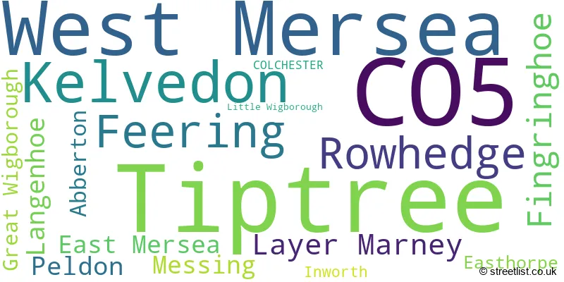
The largest settlement in the CO5 postal code is Tiptree followed by West Mersea, and Kelvedon.
The postcode area has a boundary with Thames Estuary.
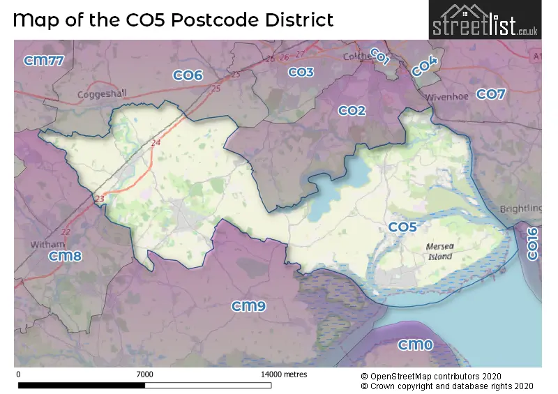
The CO5 Postcode shares a border with CM8 (WITHAM, Silver End, Wickham Bishops), CO2 (COLCHESTER, Layer-de-la-Haye, Birch), CO6 (Coggeshall, Earls Colne, West Bergholt) and CM9 (MALDON, Heybridge, Tollesbury).
In the CO5 postcode district, the primary settlement is Tiptree in the county of Essex, England. Other significant settlements include Abberton, Fingringhoe, Great Wigborough, Langenhoe, Little Wigborough, Peldon, Rowhedge, East Mersea, West Mersea, Easthorpe, Feering, Inworth, Kelvedon, Layer Marney, and Messing. The post town associated with this postcode district is Colchester.
For the district CO5, we have data on 5 postcode sectors. Here's a breakdown: The sector CO5 0, covers Tiptree in Essex. The sector CO5 1 is non-geographic. It's often designated for PO Boxes, large organisations, or special services. The sector CO5 7, covers Rowhedge and Fingringhoe and Langenhoe and Peldon in Essex. The sector CO5 8, covers West Mersea in Essex. The sector CO5 9, covers Kelvedon and Feering and Layer Marney in Essex.

Map of the CO5 Postcode District
Explore the CO5 postcode district by using our free interactive map.
When it comes to local government, postal geography often disregards political borders. However, for a breakdown in the CO5 District: the district mostly encompasses the Colchester District (B) (754 postcodes), followed by the Braintree District area (184 postcodes), and finally, the Maldon District (B) area (23 postcodes).
Weather Forecast for CO5
Press Button to Show Forecast for West Mersea
| Time Period | Icon | Description | Temperature | Rain Probability | Wind |
|---|---|---|---|---|---|
| 09:00 to 12:00 | Overcast | 6.0°C (feels like 4.0°C) | 49.00% | WSW 7 mph | |
| 12:00 to 15:00 | Light rain | 7.0°C (feels like 5.0°C) | 59.00% | WNW 7 mph | |
| 15:00 to 18:00 | Light rain | 8.0°C (feels like 5.0°C) | 49.00% | NNW 13 mph | |
| 18:00 to 21:00 | Partly cloudy (day) | 8.0°C (feels like 4.0°C) | 1.00% | NNW 16 mph | |
| 21:00 to 00:00 | Cloudy | 6.0°C (feels like 3.0°C) | 4.00% | NNW 9 mph |
Press Button to Show Forecast for West Mersea
| Time Period | Icon | Description | Temperature | Rain Probability | Wind |
|---|---|---|---|---|---|
| 00:00 to 03:00 | Cloudy | 5.0°C (feels like 1.0°C) | 8.00% | NW 11 mph | |
| 03:00 to 06:00 | Overcast | 4.0°C (feels like 0.0°C) | 8.00% | NW 13 mph | |
| 06:00 to 09:00 | Cloudy | 4.0°C (feels like 0.0°C) | 5.00% | NW 13 mph | |
| 09:00 to 12:00 | Cloudy | 7.0°C (feels like 3.0°C) | 6.00% | NNW 18 mph | |
| 12:00 to 15:00 | Cloudy | 9.0°C (feels like 5.0°C) | 13.00% | NNW 18 mph | |
| 15:00 to 18:00 | Overcast | 9.0°C (feels like 6.0°C) | 8.00% | NNW 18 mph | |
| 18:00 to 21:00 | Cloudy | 8.0°C (feels like 5.0°C) | 3.00% | N 13 mph | |
| 21:00 to 00:00 | Partly cloudy (night) | 5.0°C (feels like 3.0°C) | 1.00% | N 7 mph |
Press Button to Show Forecast for West Mersea
| Time Period | Icon | Description | Temperature | Rain Probability | Wind |
|---|---|---|---|---|---|
| 00:00 to 03:00 | Cloudy | 5.0°C (feels like 3.0°C) | 4.00% | W 7 mph | |
| 03:00 to 06:00 | Cloudy | 5.0°C (feels like 2.0°C) | 4.00% | WSW 9 mph | |
| 06:00 to 09:00 | Cloudy | 6.0°C (feels like 2.0°C) | 6.00% | W 11 mph | |
| 09:00 to 12:00 | Cloudy | 8.0°C (feels like 5.0°C) | 7.00% | W 13 mph | |
| 12:00 to 15:00 | Cloudy | 9.0°C (feels like 7.0°C) | 14.00% | WNW 13 mph | |
| 15:00 to 18:00 | Cloudy | 10.0°C (feels like 8.0°C) | 17.00% | WNW 11 mph | |
| 18:00 to 21:00 | Cloudy | 9.0°C (feels like 7.0°C) | 14.00% | NNW 9 mph | |
| 21:00 to 00:00 | Partly cloudy (night) | 7.0°C (feels like 5.0°C) | 4.00% | N 9 mph |
Press Button to Show Forecast for West Mersea
| Time Period | Icon | Description | Temperature | Rain Probability | Wind |
|---|---|---|---|---|---|
| 00:00 to 03:00 | Cloudy | 5.0°C (feels like 3.0°C) | 4.00% | N 7 mph | |
| 03:00 to 06:00 | Cloudy | 4.0°C (feels like 2.0°C) | 4.00% | N 7 mph | |
| 06:00 to 09:00 | Cloudy | 5.0°C (feels like 3.0°C) | 5.00% | NNE 7 mph | |
| 09:00 to 12:00 | Cloudy | 8.0°C (feels like 6.0°C) | 6.00% | ENE 9 mph | |
| 12:00 to 15:00 | Cloudy | 9.0°C (feels like 7.0°C) | 9.00% | SE 11 mph | |
| 15:00 to 18:00 | Cloudy | 10.0°C (feels like 7.0°C) | 11.00% | SE 11 mph | |
| 18:00 to 21:00 | Cloudy | 9.0°C (feels like 7.0°C) | 11.00% | ESE 11 mph | |
| 21:00 to 00:00 | Cloudy | 9.0°C (feels like 6.0°C) | 14.00% | ESE 13 mph |
Press Button to Show Forecast for West Mersea
| Time Period | Icon | Description | Temperature | Rain Probability | Wind |
|---|---|---|---|---|---|
| 00:00 to 03:00 | Cloudy | 9.0°C (feels like 6.0°C) | 19.00% | ESE 13 mph | |
| 03:00 to 06:00 | Cloudy | 9.0°C (feels like 7.0°C) | 19.00% | SSE 11 mph | |
| 06:00 to 09:00 | Cloudy | 9.0°C (feels like 7.0°C) | 14.00% | SE 11 mph | |
| 09:00 to 12:00 | Cloudy | 10.0°C (feels like 8.0°C) | 16.00% | SE 13 mph | |
| 12:00 to 15:00 | Cloudy | 11.0°C (feels like 8.0°C) | 16.00% | ESE 13 mph | |
| 15:00 to 18:00 | Cloudy | 12.0°C (feels like 9.0°C) | 15.00% | ESE 13 mph | |
| 18:00 to 21:00 | Cloudy | 11.0°C (feels like 9.0°C) | 12.00% | ESE 13 mph | |
| 21:00 to 00:00 | Cloudy | 11.0°C (feels like 8.0°C) | 12.00% | ESE 13 mph |
Where is the CO5 Postcode District?
The data shows that the postcode district CO5 is located in COLCHESTER. It is near several towns, including Maldon, Witham, Bures, Southminster, Halstead, Clacton-on-Sea, and Manningtree. The distance to the center of London is approximately 46.46 miles.
The district is within the post town of COLCHESTER.
The sector has postcodes within the nation of England.
The CO5 Postcode District is covers the following regions.
- Essex Haven Gateway - Essex - East of England
- Heart of Essex - Essex - East of England
| Postcode Sector | Delivery Office |
|---|---|
| CO5 0 | Tiptree Delivery Office |
| CO5 7 | Colchester Delivery Office |
| CO5 7 | Rowhedge Scale Payment Delivery Office |
| CO5 7 | Fingringhoe Scale Payment Delivery Office |
| CO5 8 | West Mersea Postal Delivery Office |
| CO5 9 | Kelvedelivery Officen Scale Payment Delivery Office |
| CO5 9 | Tiptree Delivery Office |
| C | O | 5 | - | X | X | X |
| C | O | 5 | Space | Numeric | Letter | Letter |
Tourist Attractions within the Postcode Area
We found 4 visitor attractions within the CO5 postcode area
| Layer Marney Tower |
|---|
| Historic Properties |
| Historic House / House and Garden / Palace |
| View Layer Marney Tower on Google Maps |
| Mersea Island Museum |
| Museums & Art Galleries |
| Museum and / or Art Gallery |
| View Mersea Island Museum on Google Maps |
| Feering & Kelvedon Local History Museum |
| Museums & Art Galleries |
| Museum and / or Art Gallery |
| View Feering & Kelvedon Local History Museum on Google Maps |
| Feeringbury Manor |
| Gardens |
| Garden |
| View Feeringbury Manor on Google Maps |
Current Monthly Rental Prices
| # Bedrooms | Min Price | Max Price | Avg Price |
|---|---|---|---|
| 1 | £625 | £800 | £700 |
| 2 | £800 | £1,300 | £1,072 |
| 3 | £1,150 | £1,700 | £1,425 |
| 4 | £1,650 | £1,650 | £1,650 |
Current House Prices
| # Bedrooms | Min Price | Max Price | Avg Price |
|---|---|---|---|
| £1,345,000 | £1,345,000 | £1,345,000 | |
| 3 | £1,000,000 | £1,100,000 | £1,050,000 |
| 4 | £1,000,000 | £1,600,000 | £1,362,500 |
| 5 | £1,100,000 | £2,850,000 | £1,470,833 |
| 6 | £1,250,000 | £1,500,000 | £1,420,000 |
| 7 | £5,750,000 | £5,750,000 | £5,750,000 |
Estate Agents who Operate in the CO5 District
| Logo | Name | Brand Name | Address | Contact Number | Total Properties |
|---|---|---|---|---|---|
 | West Mersea | Oakheart Property | 34a Barfield Road, West Mersea, CO5 8QT | 01206 581881 | 48 |
 | West Mersea | Moores Estate Agents | 31 High Street West Mersea CO5 8QA | 01206 586092 | 47 |
 | Tiptree | David Martin Estate Agents | 35a Church Road Tiptree CO5 0SU | 01621 738346 | 27 |
 | West Mersea | Game Estate Agents | 41a High Street West Mersea Essex CO5 8QA | 01206 586072 | 26 |
 | Tiptree | John Alexander Estate Agents & Letting Agents | 1 Church Road, Tiptree, CO5 0LG | 01621 738588 | 22 |
- Abberton
- Barrow Hill
- Coggeshall
- Coggeshall Hamlet
- Colchester
- East Mersea
- Easthorpe
- Feering
- Fingringhoe
- Great Totham
- Great Wigborough
- High Park Corner
- Inworth
- Kelvedon
- Langenhoe
- Layer Marney
- Little Tey
- Little Wigborough
- Messing
- Mulberry Green
- Peldon
- Rivenhall End
- Rivenhall
- Rowhedge
- Salcott-cum-Virley
- Silver End
- Smythe's Green
- Stocks Green
- Surrex
- Tiptree
- Tiptree Heath
- Tolleshunt Knights
- West Mersea
- Windmill Hill
| Type of Property | 2018 Average | 2018 Sales | 2017 Average | 2017 Sales | 2016 Average | 2016 Sales | 2015 Average | 2015 Sales |
|---|---|---|---|---|---|---|---|---|
| Detached | £456,642 | 219 | £416,403 | 224 | £410,048 | 299 | £392,471 | 260 |
| Semi-Detached | £303,511 | 153 | £290,978 | 135 | £287,025 | 129 | £245,366 | 175 |
| Terraced | £291,716 | 93 | £276,381 | 93 | £251,061 | 66 | £217,381 | 84 |
| Flats | £185,674 | 60 | £178,801 | 58 | £160,369 | 65 | £165,076 | 64 |