The CO5 7 postcode sector is within the county of Essex.
Did you know? According to the 2021 Census, the CO5 7 postcode sector is home to a bustling 5,109 residents!
Given that each sector allows for 400 unique postcode combinations. Letters C, I, K, M, O and V are not allowed in the last two letters of a postcode. With 170 postcodes already in use, this leaves 230 units available.
The largest settlement in the CO5 7 postal code is Rowhedge followed by Fingringhoe, and Peldon.
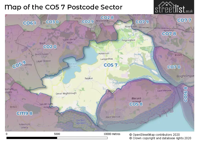
The CO5 7 Postcode shares a border with CO2 0 (Layer-de-la-Haye, COLCHESTER, Birch), CO2 8 (COLCHESTER), CM9 8 (Tollesbury, Great Totham, Tolleshunt D'Arcy), CO5 8 (West Mersea, East Mersea) and CO5 9 (Kelvedon, Feering, Layer Marney).
The sector is within the post town of COLCHESTER.
CO5 7 is a postcode sector within the CO5 postcode district which is within the CO Colchester postcode area.
The Royal Mail delivery office for the CO5 7 postal sector is the Colchester Delivery Office and Rowhedge Scale Payment Delivery Office and Fingringhoe Scale Payment Delivery Office.
The area of the CO5 7 postcode sector is 20.62 square miles which is 53.41 square kilometres or 13,198.29 square acres.
Waterways within the CO5 7 postcode sector include the Roman River, Layer Brook.

Map of the CO5 7 Postcode Sector
Explore the CO5 7 postcode sector by using our free interactive map.
| C | O | 5 | - | 7 | X | X |
| C | O | 5 | Space | 7 | Letter | Letter |
Official List of Streets
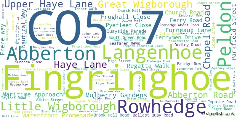
Fingringhoe (15 Streets)
Great Wigborough (6 Streets)
Rowhedge (43 Streets)
Abberton (8 Streets)
Langenhoe (13 Streets)
Peldon (14 Streets)
Little Wigborough (2 Streets)
Unofficial Streets or Alternative Spellings
Weather Forecast for CO5 7
Press Button to Show Forecast for West Mersea
| Time Period | Icon | Description | Temperature | Rain Probability | Wind |
|---|---|---|---|---|---|
| 03:00 to 06:00 | Cloudy | 6.0°C (feels like 3.0°C) | 7.00% | SW 9 mph | |
| 06:00 to 09:00 | Cloudy | 7.0°C (feels like 4.0°C) | 7.00% | WSW 11 mph | |
| 09:00 to 12:00 | Cloudy | 9.0°C (feels like 7.0°C) | 5.00% | WSW 11 mph | |
| 12:00 to 15:00 | Overcast | 9.0°C (feels like 6.0°C) | 12.00% | WNW 13 mph | |
| 15:00 to 18:00 | Light rain | 9.0°C (feels like 6.0°C) | 40.00% | NNW 13 mph | |
| 18:00 to 21:00 | Cloudy | 8.0°C (feels like 5.0°C) | 12.00% | NNE 9 mph | |
| 21:00 to 00:00 | Cloudy | 6.0°C (feels like 4.0°C) | 7.00% | NNE 7 mph |
Press Button to Show Forecast for West Mersea
| Time Period | Icon | Description | Temperature | Rain Probability | Wind |
|---|---|---|---|---|---|
| 00:00 to 03:00 | Partly cloudy (night) | 4.0°C (feels like 2.0°C) | 1.00% | NNE 7 mph | |
| 03:00 to 06:00 | Partly cloudy (night) | 3.0°C (feels like 1.0°C) | 1.00% | N 7 mph | |
| 06:00 to 09:00 | Partly cloudy (day) | 4.0°C (feels like 2.0°C) | 1.00% | NNE 7 mph | |
| 09:00 to 12:00 | Partly cloudy (day) | 8.0°C (feels like 6.0°C) | 1.00% | ENE 7 mph | |
| 12:00 to 15:00 | Cloudy | 9.0°C (feels like 7.0°C) | 5.00% | ESE 9 mph | |
| 15:00 to 18:00 | Overcast | 9.0°C (feels like 7.0°C) | 12.00% | ESE 9 mph | |
| 18:00 to 21:00 | Cloudy | 9.0°C (feels like 6.0°C) | 10.00% | E 11 mph | |
| 21:00 to 00:00 | Cloudy | 8.0°C (feels like 5.0°C) | 11.00% | E 11 mph |
Press Button to Show Forecast for West Mersea
| Time Period | Icon | Description | Temperature | Rain Probability | Wind |
|---|---|---|---|---|---|
| 00:00 to 03:00 | Cloudy | 8.0°C (feels like 5.0°C) | 14.00% | E 11 mph | |
| 03:00 to 06:00 | Light rain | 8.0°C (feels like 5.0°C) | 47.00% | ENE 11 mph | |
| 06:00 to 09:00 | Cloudy | 8.0°C (feels like 5.0°C) | 19.00% | E 13 mph | |
| 09:00 to 12:00 | Cloudy | 10.0°C (feels like 7.0°C) | 15.00% | E 13 mph | |
| 12:00 to 15:00 | Cloudy | 11.0°C (feels like 8.0°C) | 14.00% | ESE 13 mph | |
| 15:00 to 18:00 | Cloudy | 11.0°C (feels like 9.0°C) | 12.00% | E 13 mph | |
| 18:00 to 21:00 | Cloudy | 11.0°C (feels like 8.0°C) | 21.00% | ENE 13 mph | |
| 21:00 to 00:00 | Light rain | 11.0°C (feels like 8.0°C) | 50.00% | E 13 mph |
Press Button to Show Forecast for West Mersea
| Time Period | Icon | Description | Temperature | Rain Probability | Wind |
|---|---|---|---|---|---|
| 00:00 to 03:00 | Light rain | 11.0°C (feels like 8.0°C) | 53.00% | E 13 mph | |
| 03:00 to 06:00 | Heavy rain | 10.0°C (feels like 8.0°C) | 72.00% | ESE 13 mph | |
| 06:00 to 09:00 | Heavy rain | 11.0°C (feels like 8.0°C) | 71.00% | SSE 16 mph | |
| 09:00 to 12:00 | Light rain shower (day) | 11.0°C (feels like 8.0°C) | 43.00% | SSE 18 mph | |
| 12:00 to 15:00 | Light rain shower (day) | 12.0°C (feels like 9.0°C) | 38.00% | S 18 mph | |
| 15:00 to 18:00 | Light rain shower (day) | 13.0°C (feels like 10.0°C) | 37.00% | SSW 16 mph | |
| 18:00 to 21:00 | Sunny day | 12.0°C (feels like 10.0°C) | 12.00% | SSW 13 mph | |
| 21:00 to 00:00 | Partly cloudy (night) | 11.0°C (feels like 8.0°C) | 6.00% | SSW 13 mph |
Schools and Places of Education Within the CO5 7 Postcode Sector
Fingringhoe Church of England Voluntary Aided Primary School
Voluntary aided school
Church Road, Colchester, Essex, CO5 7BN
Head: Co Headteacher Hannah Coyle Donna Parker
Ofsted Rating: Good
Inspection: 2023-06-28 (302 days ago)
Website: Visit Fingringhoe Church of England Voluntary Aided Primary School Website
Phone: 01206729266
Number of Pupils: 87
Langenhoe Community Primary School
Community school
Bracken Way, Colchester, Essex, CO5 7PG
Head: Mrs Sarah Stevenson
Ofsted Rating: Good
Inspection: 2023-01-11 (470 days ago)
Website: Visit Langenhoe Community Primary School Website
Phone: 01206735267
Number of Pupils: 121
St Lawrence Church of England Primary School, Rowhedge
Voluntary controlled school
Rectory Road, Colchester, Essex, CO5 7HR
Head: Mrs Kerry Malcolm
Ofsted Rating: Good
Inspection: 2019-02-06 (1905 days ago)
Website: Visit St Lawrence Church of England Primary School, Rowhedge Website
Phone: 01206728517
Number of Pupils: 225
House Prices in the CO5 7 Postcode Sector
| Type of Property | 2018 Average | 2018 Sales | 2017 Average | 2017 Sales | 2016 Average | 2016 Sales | 2015 Average | 2015 Sales |
|---|---|---|---|---|---|---|---|---|
| Detached | £462,708 | 36 | £453,861 | 36 | £424,162 | 40 | £417,286 | 42 |
| Semi-Detached | £312,011 | 34 | £274,546 | 31 | £263,367 | 34 | £239,216 | 29 |
| Terraced | £309,396 | 47 | £278,167 | 38 | £238,409 | 22 | £188,607 | 14 |
| Flats | £182,393 | 19 | £171,260 | 21 | £151,323 | 17 | £124,750 | 14 |
Important Postcodes CO5 7 in the Postcode Sector
CO5 7HR is the postcode for St. Lawrence C of E Primary School, Rectory Road
CO5 7PG is the postcode for Langenhoe Community Primary School, Bracken Way
| The CO5 7 Sector is within these Local Authorities |
|
|---|---|
| The CO5 7 Sector is within these Counties |
|
| The CO5 7 Sector is within these Water Company Areas |
|