The CO6 1 postcode sector is within the county of Essex.
Did you know? According to the 2021 Census, the CO6 1 postcode sector is home to a bustling 9,750 residents!
Given that each sector allows for 400 unique postcode combinations. Letters C, I, K, M, O and V are not allowed in the last two letters of a postcode. With 278 postcodes already in use, this leaves 122 units available.
The largest settlement in the CO6 1 postal code is Coggeshall followed by Marks Tey, and Copford.
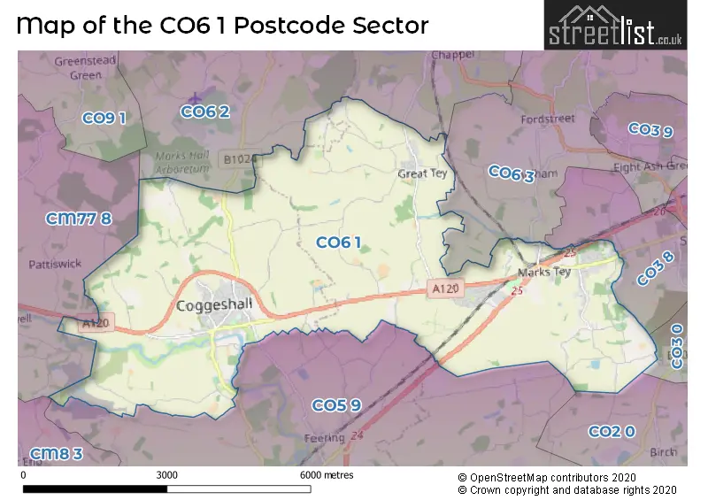
The CO6 1 Postcode shares a border with CO2 0 (Layer-de-la-Haye, COLCHESTER, Birch), CO3 0 (Stanway), CO3 8 (Stanway, Lexden Heath), CM8 3 (Silver End, Wickham Bishops, WITHAM), CM77 8 (Cressing, Black Notley, Stisted), CO5 9 (Kelvedon, Feering, Layer Marney), CO6 2 (Earls Colne, Colne Engaine, White Colne) and CO6 3 (West Bergholt, Fordham, Eight Ash Green).
The sector is within the post town of COLCHESTER.
CO6 1 is a postcode sector within the CO6 postcode district which is within the CO Colchester postcode area.
The Royal Mail delivery office for the CO6 1 postal sector is the Coggeshall Scale Payment Delivery Office and Marks Tey Scale Payment Delivery Office.
The area of the CO6 1 postcode sector is 16.49 square miles which is 42.71 square kilometres or 10,553.11 square acres.
The CO6 1 postcode sector is crossed by the A12 Major A road.
The CO6 1 postcode sector is crossed by the A120 Major A road.
Waterways within the CO6 1 postcode sector include the Roman River, Robin's Brook, Domsey Brook, Blackwater.

Map of the CO6 1 Postcode Sector
Explore the CO6 1 postcode sector by using our free interactive map.
| C | O | 6 | - | 1 | X | X |
| C | O | 6 | Space | 1 | Letter | Letter |
Official List of Streets
Coggeshall (79 Streets)
Copford (22 Streets)
Marks Tey (42 Streets)
Great Tey (21 Streets)
Little Tey (2 Streets)
Unofficial Streets or Alternative Spellings
Heckfordbridge
FOUNTAIN LANE ALDERCAR ROAD ASBURY DRIVE BALDWINS LANE BOARDED BARN LANE BRACKS LANE BROOKHOUSE ROAD COGGESHALL 41 / FEERING 1 COGGESHALL BYPASS COGGESHALL ROAD (FEERING) COPGGESHALL 66 COPINGFORD END CRANMERS LANE DOGGETTS LANE FINAL FOR ESSEX WAY FITCHES CROFT FLORIES ROAD FRANCIS COURT HALL CHASE HOLFIELD GRANGE ROAD HOLLILAND COURT HOUCHINS LANE HOVELLS FARM ROAD ISINGLASS MEWS MARKS TEY 11 MARKS TEY ROUNDABOUT MELLINGS MONKSDOWN ROAD MOTTS PATH NUNNS BRIDGE PRINCE OF WALES ROUNDABOUT QUEENSBURY AVENUE ROMAN WILLOWS FOOTBRIDGE SAINT PETERS ROAD SCRIPS ROAD SERE LANE SKYE GREEN LANE ST. MICHAELS CHASE SWAN YARD SWANSCOMB ROAD THE CHASE THE ESSEX WAY THE ROOKERIES TURKEY COCK ROMAN WAY WATERY LANE WHITEHOUSE FARM ROAD WILLOWS WALK WINDMILL COURT WITCH LANEChappel
OAK ROAD PATTOCKS LANE SWAN STREETEarls Colne
AMERICA ROAD TEY ROADAldham
BROOK ROAD TEY ROADBradwell
COGGESHALL ROADWeather Forecast for CO6 1
Press Button to Show Forecast for Tiptree
| Time Period | Icon | Description | Temperature | Rain Probability | Wind |
|---|---|---|---|---|---|
| 15:00 to 18:00 | Cloudy | 9.0°C (feels like 6.0°C) | 28.00% | NNW 11 mph | |
| 18:00 to 21:00 | Cloudy | 7.0°C (feels like 5.0°C) | 12.00% | NNE 7 mph | |
| 21:00 to 00:00 | Cloudy | 5.0°C (feels like 3.0°C) | 7.00% | NNE 4 mph |
Press Button to Show Forecast for Tiptree
| Time Period | Icon | Description | Temperature | Rain Probability | Wind |
|---|---|---|---|---|---|
| 00:00 to 03:00 | Partly cloudy (night) | 3.0°C (feels like 1.0°C) | 1.00% | NNE 4 mph | |
| 03:00 to 06:00 | Partly cloudy (night) | 2.0°C (feels like -1.0°C) | 1.00% | NNE 4 mph | |
| 06:00 to 09:00 | Partly cloudy (day) | 3.0°C (feels like 1.0°C) | 1.00% | NNE 4 mph | |
| 09:00 to 12:00 | Partly cloudy (day) | 8.0°C (feels like 6.0°C) | 2.00% | ENE 7 mph | |
| 12:00 to 15:00 | Overcast | 9.0°C (feels like 8.0°C) | 9.00% | E 7 mph | |
| 15:00 to 18:00 | Overcast | 9.0°C (feels like 7.0°C) | 12.00% | ESE 9 mph | |
| 18:00 to 21:00 | Cloudy | 8.0°C (feels like 6.0°C) | 12.00% | E 9 mph | |
| 21:00 to 00:00 | Cloudy | 6.0°C (feels like 4.0°C) | 10.00% | E 9 mph |
Press Button to Show Forecast for Tiptree
| Time Period | Icon | Description | Temperature | Rain Probability | Wind |
|---|---|---|---|---|---|
| 00:00 to 03:00 | Cloudy | 6.0°C (feels like 4.0°C) | 13.00% | ENE 9 mph | |
| 03:00 to 06:00 | Light rain | 6.0°C (feels like 3.0°C) | 44.00% | ENE 9 mph | |
| 06:00 to 09:00 | Light rain | 7.0°C (feels like 4.0°C) | 45.00% | ENE 9 mph | |
| 09:00 to 12:00 | Cloudy | 9.0°C (feels like 7.0°C) | 15.00% | E 11 mph | |
| 12:00 to 15:00 | Overcast | 11.0°C (feels like 9.0°C) | 19.00% | E 11 mph | |
| 15:00 to 18:00 | Cloudy | 12.0°C (feels like 9.0°C) | 16.00% | E 11 mph | |
| 18:00 to 21:00 | Cloudy | 11.0°C (feels like 8.0°C) | 21.00% | E 11 mph | |
| 21:00 to 00:00 | Light rain | 10.0°C (feels like 7.0°C) | 49.00% | ENE 11 mph |
Press Button to Show Forecast for Tiptree
| Time Period | Icon | Description | Temperature | Rain Probability | Wind |
|---|---|---|---|---|---|
| 00:00 to 03:00 | Light rain | 9.0°C (feels like 7.0°C) | 54.00% | E 11 mph | |
| 03:00 to 06:00 | Light rain | 9.0°C (feels like 7.0°C) | 51.00% | ESE 11 mph | |
| 06:00 to 09:00 | Light rain | 10.0°C (feels like 7.0°C) | 51.00% | SE 11 mph | |
| 09:00 to 12:00 | Light rain shower (day) | 11.0°C (feels like 8.0°C) | 39.00% | SSE 13 mph | |
| 12:00 to 15:00 | Light rain shower (day) | 12.0°C (feels like 10.0°C) | 41.00% | S 16 mph | |
| 15:00 to 18:00 | Heavy rain shower (day) | 13.0°C (feels like 11.0°C) | 55.00% | S 13 mph | |
| 18:00 to 21:00 | Partly cloudy (day) | 12.0°C (feels like 10.0°C) | 14.00% | SSW 11 mph | |
| 21:00 to 00:00 | Partly cloudy (night) | 9.0°C (feels like 7.0°C) | 4.00% | SSW 9 mph |
Schools and Places of Education Within the CO6 1 Postcode Sector
Copford Church of England Voluntary Controlled Primary School
Voluntary controlled school
School Road, Colchester, Essex, CO6 1BX
Head: Mr David Bome
Ofsted Rating: Good
Inspection: 2021-11-12 (895 days ago)
Website: Visit Copford Church of England Voluntary Controlled Primary School Website
Phone: 01206210439
Number of Pupils: 217
Great Tey Church of England Voluntary Controlled Primary School
Voluntary controlled school
Chrismund Way, Colchester, Essex, CO6 1AZ
Head: Mrs Lucy Overton
Ofsted Rating: Good
Inspection: 2018-07-17 (2109 days ago)
Website: Visit Great Tey Church of England Voluntary Controlled Primary School Website
Phone: 01206210415
Number of Pupils: 75
St Peter's Church of England Voluntary Controlled Primary School, Coggeshall
Voluntary controlled school
Myneer Park, Colchester, Essex, CO6 1YU
Head: Ms Sam Wilding
Ofsted Rating: Good
Inspection: 2023-03-29 (393 days ago)
Website: Visit St Peter's Church of England Voluntary Controlled Primary School, Coggeshall Website
Phone: 01376561328
Number of Pupils: 321
The Honywood Community Science School
Academy converter
Westfield Drive, Colchester, Essex, CO6 1PZ
Head: Mr James Saunders
Ofsted Rating: Good
Inspection: 2022-12-07 (505 days ago)
Website: Visit The Honywood Community Science School Website
Phone: 01376561231
Number of Pupils: 789
House Prices in the CO6 1 Postcode Sector
| Type of Property | 2018 Average | 2018 Sales | 2017 Average | 2017 Sales | 2016 Average | 2016 Sales | 2015 Average | 2015 Sales |
|---|---|---|---|---|---|---|---|---|
| Detached | £458,037 | 64 | £436,759 | 79 | £449,274 | 74 | £435,835 | 78 |
| Semi-Detached | £307,659 | 44 | £311,704 | 54 | £319,209 | 53 | £274,303 | 59 |
| Terraced | £331,310 | 29 | £257,282 | 31 | £267,594 | 24 | £325,722 | 36 |
| Flats | £151,337 | 31 | £145,436 | 19 | £148,361 | 40 | £129,818 | 25 |
Important Postcodes CO6 1 in the Postcode Sector
CO6 1AZ is the postcode for Great Tey Primary School, Chrismund Way
CO6 1HL is the postcode for St. Andrews C of E Primary School, Mandeville Road, and MAIN BUILDING, St. Andrews C of E Primary School, Mandeville Road
CO6 1PZ is the postcode for MAIN BUILDING, Honywood Community Science School, Honeywood Avenue
CO6 1YU is the postcode for St. Peters C of E Primary School, Myneer Park, and MAIN BUILDING, St. Peters C of E Primary School, Myneer Park
| The CO6 1 Sector is within these Local Authorities |
|
|---|---|
| The CO6 1 Sector is within these Counties |
|
| The CO6 1 Sector is within these Water Company Areas |
|
Tourist Attractions within the CO6 1 Postcode Area
We found 2 visitor attractions within the CO6 postcode area
| Paycocke's House and Garden |
|---|
| Historic Properties |
| Historic House / House and Garden / Palace |
| View Paycocke's House and Garden on Google Maps |
| Coggeshall Grange Barn |
| Historic Properties |
| Other Historic Property |
| View Coggeshall Grange Barn on Google Maps |