The CO9 postcode district is a postal district located in the CO Colchester postcode area with a population of 27,821 residents according to the 2021 England and Wales Census.
The area of the CO9 postcode district is 61.61 square miles which is 159.58 square kilometres or 39,432.74 acres.
Currently, the CO9 district has about 905 postcode units spread across 4 geographic postcode sectors.
Given that each sector allows for 400 unique postcode combinations, the district has a capacity of 1,600 postcodes. With 905 postcodes already in use, this leaves 695 units available.
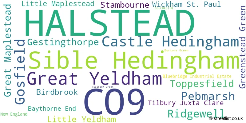
The largest settlement in the CO9 postal code is HALSTEAD followed by Sible Hedingham, and Great Yeldham.
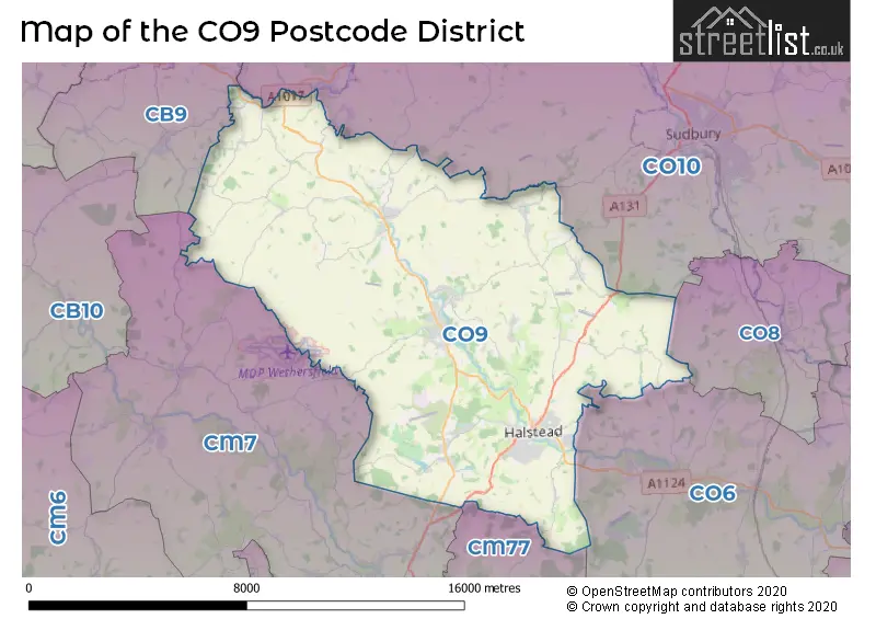
The CO9 Postcode shares a border with CB9 (HAVERHILL, Kedington, Steeple Bumpstead), CO10 (SUDBURY, Great Cornard, Long Melford), CO8 (BURES, Mount Bures, Alphamstone), CM7 (BRAINTREE, Great Bardfield, Wethersfield), CM77 (Great Notley, Rayne, Cressing) and CO6 (Coggeshall, Earls Colne, West Bergholt).
In the CO9 postcode district, the primary settlement is Halstead, located in the county of Essex in England. Other significant settlements in the district include Castle Hedingham, Sible Hedingham, Gosfield, Great Yeldham, and Birdbrook. The most significant post town in the district is Halstead.
For the district CO9, we have data on 5 postcode sectors. Here's a breakdown: The sector CO9 1, covers Halstead and Gosfield in Essex. The sector CO9 2, covers Halstead and Pebmarsh in Essex. The sector CO9 3, covers Sible Hedingham and Castle Hedingham and Gestingthorpe in Essex. The sector CO9 4, covers Great Yeldham and Ridgewell and Toppesfield in Essex. The sector CO9 9 is non-geographic. It's often designated for PO Boxes, large organisations, or special services.

Map of the CO9 Postcode District
Explore the CO9 postcode district by using our free interactive map.
When it comes to local government, postal geography often disregards political borders. However, for a breakdown in the CO9 District: the district mostly encompasses the Braintree District area with a total of 924 postcodes.
Weather Forecast for CO9
Press Button to Show Forecast for Sible Hedingham
| Time Period | Icon | Description | Temperature | Rain Probability | Wind |
|---|---|---|---|---|---|
| 15:00 to 18:00 | Cloudy | 10.0°C (feels like 7.0°C) | 12.00% | N 16 mph | |
| 18:00 to 21:00 | Sunny day | 7.0°C (feels like 4.0°C) | 1.00% | N 16 mph | |
| 21:00 to 00:00 | Clear night | 5.0°C (feels like 1.0°C) | 0.00% | NNW 11 mph |
Press Button to Show Forecast for Sible Hedingham
| Time Period | Icon | Description | Temperature | Rain Probability | Wind |
|---|---|---|---|---|---|
| 00:00 to 03:00 | Clear night | 4.0°C (feels like 0.0°C) | 0.00% | NW 11 mph | |
| 03:00 to 06:00 | Cloudy | 3.0°C (feels like -1.0°C) | 6.00% | NW 9 mph | |
| 06:00 to 09:00 | Cloudy | 4.0°C (feels like 0.0°C) | 4.00% | NNW 11 mph | |
| 09:00 to 12:00 | Overcast | 7.0°C (feels like 3.0°C) | 8.00% | NNW 13 mph | |
| 12:00 to 15:00 | Cloudy | 9.0°C (feels like 6.0°C) | 5.00% | NNW 16 mph | |
| 15:00 to 18:00 | Cloudy | 9.0°C (feels like 6.0°C) | 4.00% | N 13 mph | |
| 18:00 to 21:00 | Partly cloudy (day) | 8.0°C (feels like 5.0°C) | 1.00% | N 11 mph | |
| 21:00 to 00:00 | Clear night | 5.0°C (feels like 2.0°C) | 1.00% | N 7 mph |
Press Button to Show Forecast for Sible Hedingham
| Time Period | Icon | Description | Temperature | Rain Probability | Wind |
|---|---|---|---|---|---|
| 00:00 to 03:00 | Cloudy | 4.0°C (feels like 1.0°C) | 4.00% | NNW 7 mph | |
| 03:00 to 06:00 | Overcast | 4.0°C (feels like 1.0°C) | 7.00% | NNW 7 mph | |
| 06:00 to 09:00 | Overcast | 4.0°C (feels like 1.0°C) | 9.00% | NNW 9 mph | |
| 09:00 to 12:00 | Overcast | 7.0°C (feels like 4.0°C) | 10.00% | N 11 mph | |
| 12:00 to 15:00 | Overcast | 9.0°C (feels like 6.0°C) | 10.00% | NNE 13 mph | |
| 15:00 to 18:00 | Cloudy | 10.0°C (feels like 7.0°C) | 6.00% | NNE 11 mph | |
| 18:00 to 21:00 | Sunny day | 8.0°C (feels like 6.0°C) | 3.00% | NNE 11 mph | |
| 21:00 to 00:00 | Clear night | 5.0°C (feels like 3.0°C) | 2.00% | NNE 7 mph |
Press Button to Show Forecast for Sible Hedingham
| Time Period | Icon | Description | Temperature | Rain Probability | Wind |
|---|---|---|---|---|---|
| 00:00 to 03:00 | Cloudy | 4.0°C (feels like 1.0°C) | 4.00% | N 7 mph | |
| 03:00 to 06:00 | Partly cloudy (night) | 3.0°C (feels like 0.0°C) | 2.00% | N 7 mph | |
| 06:00 to 09:00 | Partly cloudy (day) | 4.0°C (feels like 1.0°C) | 2.00% | N 7 mph | |
| 09:00 to 12:00 | Cloudy | 8.0°C (feels like 6.0°C) | 7.00% | N 9 mph | |
| 12:00 to 15:00 | Overcast | 9.0°C (feels like 7.0°C) | 15.00% | N 9 mph | |
| 15:00 to 18:00 | Overcast | 9.0°C (feels like 7.0°C) | 17.00% | N 9 mph | |
| 18:00 to 21:00 | Cloudy | 8.0°C (feels like 6.0°C) | 14.00% | N 7 mph | |
| 21:00 to 00:00 | Cloudy | 6.0°C (feels like 4.0°C) | 12.00% | NE 4 mph |
Press Button to Show Forecast for Sible Hedingham
| Time Period | Icon | Description | Temperature | Rain Probability | Wind |
|---|---|---|---|---|---|
| 00:00 to 03:00 | Cloudy | 4.0°C (feels like 2.0°C) | 10.00% | NNE 4 mph | |
| 03:00 to 06:00 | Cloudy | 4.0°C (feels like 2.0°C) | 11.00% | NW 4 mph | |
| 06:00 to 09:00 | Cloudy | 5.0°C (feels like 3.0°C) | 10.00% | N 7 mph | |
| 09:00 to 12:00 | Light rain | 8.0°C (feels like 6.0°C) | 39.00% | NNE 9 mph | |
| 12:00 to 15:00 | Light rain | 10.0°C (feels like 8.0°C) | 42.00% | NNE 9 mph | |
| 15:00 to 18:00 | Light rain | 10.0°C (feels like 8.0°C) | 50.00% | NNE 9 mph | |
| 18:00 to 21:00 | Cloudy | 9.0°C (feels like 7.0°C) | 7.00% | NNE 9 mph | |
| 21:00 to 00:00 | Overcast | 6.0°C (feels like 4.0°C) | 16.00% | N 7 mph |
Where is the CO9 Postcode District?
The data provided indicates that the CO9 postcode is located in the HALSTEAD district town. HALSTEAD is surrounded by several nearby towns, including BRAINTREE to the south, SUDBURY to the north-east, BURES to the east, HAVERHILL to the north-west, DUNMOW to the south-west, COLCHESTER to the south-east, and SAFFRON WALDEN to the west. Furthermore, the distance between HALSTEAD and London is approximately 45.1 miles.
The district covers the post towns of COLCHESTER, HALSTEAD.
The sector has postcodes within the nation of England.
The CO9 Postcode District is in the Essex Haven Gateway region of Essex within the East of England.
| Postcode Sector | Delivery Office |
|---|---|
| CO9 1 | Halstead Delivery Office |
| CO9 2 | Halstead Delivery Office |
| CO9 3 | Halstead Delivery Office |
| CO9 3 | Sible Hedingham Scale Payment Delivery Office |
| CO9 4 | Halstead Delivery Office |
| CO9 4 | Great Yeldham Scale Payment Delivery Office |
| C | O | 9 | - | X | X | X |
| C | O | 9 | Space | Numeric | Letter | Letter |
Tourist Attractions within the Postcode Area
We found 1 visitor attractions within the CO9 postcode area
| Colne Valley Railway |
|---|
| Railways |
| Steam / Heritage Railway |
| View Colne Valley Railway on Google Maps |
Current Monthly Rental Prices
| # Bedrooms | Min Price | Max Price | Avg Price |
|---|---|---|---|
| 1 | £895 | £2,820 | £1,620 |
| 2 | £895 | £4,435 | £1,361 |
| 3 | £1,150 | £1,350 | £1,250 |
| 4 | £1,500 | £2,750 | £2,063 |
| 5 | £3,200 | £3,200 | £3,200 |
Current House Prices
| # Bedrooms | Min Price | Max Price | Avg Price |
|---|---|---|---|
| 4 | £800,000 | £1,500,000 | £1,060,000 |
| 5 | £850,000 | £2,100,000 | £1,210,556 |
| 6 | £1,000,000 | £1,250,000 | £1,116,667 |
| 7 | £1,250,000 | £1,700,000 | £1,475,000 |
| 8 | £2,300,000 | £2,300,000 | £2,300,000 |
| 10 | £2,950,000 | £2,950,000 | £2,950,000 |
Estate Agents who Operate in the CO9 District
| Logo | Name | Brand Name | Address | Contact Number | Total Properties |
|---|---|---|---|---|---|
 | Halstead | Michaels Property Consultants Ltd | 8 Bridge Street, Halstead, CO9 1HT | 01787 322107 | 49 |
 | Halstead | William H. Brown | 30 High Street, Halstead, CO9 2AF | 01787 322336 | 43 |
 | Halstead | Leaders Sales | 2 Hedingham Road, Halstead, CO9 2DA | 01787 322229 | 42 |
 | Halstead | Scott Maddison | 17 High Street, Halstead, CO9 2AA | 01787 479988 | 33 |
 | Halstead | ST. GEORGE PROPERTY GROUP | 7 Weavers Court, Halstead, CO9 2JN | 01787 321001 | 21 |
- Baythorne End
- Beazley End
- Birdbrook
- Blackmore End
- Castle Hedingham
- Clay Hills
- Cross End
- Dyer's End
- Gainsford End
- Gestingthorpe
- Gosfield
- Great Maplestead
- Great Yeldham
- Greenstead Green
- Halstead
- Little Maplestead
- Little Yeldham
- New England
- Pebmarsh
- Ridgewell
- Sible Hedingham
- Stambourne
- Tilbury Green
- Tilbury Juxta Clare
- Toppesfield
- Whiteash Green
- Wickham St Paul
- Wixoe
| Type of Property | 2018 Average | 2018 Sales | 2017 Average | 2017 Sales | 2016 Average | 2016 Sales | 2015 Average | 2015 Sales |
|---|---|---|---|---|---|---|---|---|
| Detached | £443,060 | 151 | £421,970 | 134 | £387,938 | 178 | £366,898 | 188 |
| Semi-Detached | £279,938 | 155 | £266,892 | 152 | £250,386 | 154 | £230,277 | 165 |
| Terraced | £233,473 | 132 | £233,310 | 138 | £211,348 | 136 | £199,914 | 159 |
| Flats | £153,554 | 46 | £168,109 | 63 | £144,743 | 48 | £133,392 | 56 |
Hotels within the Postcode Area
We found 14 hotels and guest houses within the CO9 postcode area
The Coach House at The Pheasant
Audley End, Gestingthorpe, Halstead, gestingthorpe, CO9 3AU.
View detailsThe Suites at Pannells Ash
Sudbury Road, Castle Hedingham, Gestingthorpe, castle-hedingham, CO9 3AD.
View detailsAnnexe at Gosfield Lake
Gosfield Lake Resort, Parkhall Road, Gosfield, gosfield, CO9 1UD.
View detailsBayley Street Bed and Breakfast
1 Bayley Street, Castle Hedingham, castle-hedingham, CO9 3HG.
View detailsHedingham Old Pottery
37 St James Street, Castle Hedingam, Castle Hedingham, castle-hedingham, CO9 3EW.
View details