The CT9 5 postcode sector is within the county of Kent.
Did you know? According to the 2021 Census, the CT9 5 postcode sector is home to a bustling 11,234 residents!
Given that each sector allows for 400 unique postcode combinations. Letters C, I, K, M, O and V are not allowed in the last two letters of a postcode. With 236 postcodes already in use, this leaves 164 units available.
The largest settlements in the CT9 5 postal code are MARGATE and Garlinge.
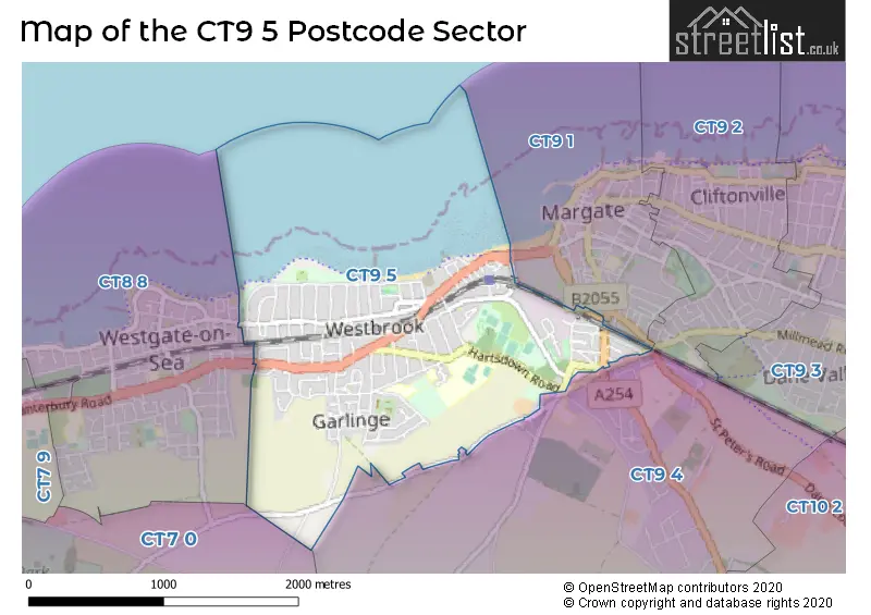
The CT9 5 Postcode shares a border with CT7 0 (BIRCHINGTON, St. Nicholas At Wade, Acol), CT8 8 (WESTGATE-ON-SEA), CT9 4 (MARGATE, Westwood), CT9 1 (MARGATE) and CT9 2 (MARGATE, Cliftonville).
The sector is within the post town of MARGATE.
CT9 5 is a postcode sector within the CT9 postcode district which is within the CT Canterbury postcode area.
The Royal Mail delivery office for the CT9 5 postal sector is the unknown.
The area of the CT9 5 postcode sector is 1.43 square miles which is 3.71 square kilometres or 916.20 square acres.

Map of the CT9 5 Postcode Sector
Explore the CT9 5 postcode sector by using our free interactive map.
| C | T | 9 | - | 5 | X | X |
| C | T | 9 | Space | 5 | Letter | Letter |
Official List of Streets
MARGATE (122 Streets)
Unofficial Streets or Alternative Spellings
MARGATE
DENT-DE-LION ROAD EATON ROAD FIRBANK GARDENS GROSVENOR GARDENS GROSVENOR PLACE MARINE TERRACEWESTGATE-ON-SEA
BEACH RISE NORMAN ROAD OLD BOUNDARY ROADBIRCHINGTON,
SHOTTENDANE ROADBrooksend
CANTERBURY ROAD ALL SAINTS INDUSTRIAL ESTATE BEACH HOUSES CANTERBURY ROAD MARGATE DENT-DE LION COURT KNOLD PARK RAILWAY TERRACE WESTBROOK PROMENADEWoodchurch
WOODCHURCH ROADWeather Forecast for CT9 5
Press Button to Show Forecast for Westbrook Bay (Beach)
| Time Period | Icon | Description | Temperature | Rain Probability | Wind |
|---|---|---|---|---|---|
| 03:00 to 06:00 | Cloudy | 6.0°C (feels like 1.0°C) | 3.00% | NNW 20 mph | |
| 06:00 to 09:00 | Cloudy | 6.0°C (feels like 2.0°C) | 3.00% | NNW 20 mph | |
| 09:00 to 12:00 | Cloudy | 8.0°C (feels like 3.0°C) | 5.00% | NNW 18 mph | |
| 12:00 to 15:00 | Cloudy | 9.0°C (feels like 6.0°C) | 5.00% | N 18 mph | |
| 15:00 to 18:00 | Cloudy | 9.0°C (feels like 6.0°C) | 5.00% | N 18 mph | |
| 18:00 to 21:00 | Cloudy | 8.0°C (feels like 5.0°C) | 7.00% | N 18 mph | |
| 21:00 to 00:00 | Cloudy | 7.0°C (feels like 3.0°C) | 3.00% | N 16 mph |
Press Button to Show Forecast for Westbrook Bay (Beach)
| Time Period | Icon | Description | Temperature | Rain Probability | Wind |
|---|---|---|---|---|---|
| 00:00 to 03:00 | Cloudy | 7.0°C (feels like 3.0°C) | 7.00% | N 16 mph | |
| 03:00 to 06:00 | Overcast | 7.0°C (feels like 3.0°C) | 8.00% | N 16 mph | |
| 06:00 to 09:00 | Overcast | 7.0°C (feels like 3.0°C) | 9.00% | N 16 mph | |
| 09:00 to 12:00 | Overcast | 8.0°C (feels like 4.0°C) | 9.00% | N 18 mph | |
| 12:00 to 15:00 | Cloudy | 9.0°C (feels like 6.0°C) | 6.00% | NNE 18 mph | |
| 15:00 to 18:00 | Cloudy | 10.0°C (feels like 6.0°C) | 5.00% | NNE 18 mph | |
| 18:00 to 21:00 | Partly cloudy (day) | 9.0°C (feels like 6.0°C) | 2.00% | NNE 16 mph | |
| 21:00 to 00:00 | Partly cloudy (night) | 8.0°C (feels like 5.0°C) | 2.00% | NNE 16 mph |
Press Button to Show Forecast for Westbrook Bay (Beach)
| Time Period | Icon | Description | Temperature | Rain Probability | Wind |
|---|---|---|---|---|---|
| 00:00 to 03:00 | Partly cloudy (night) | 8.0°C (feels like 4.0°C) | 2.00% | NNE 13 mph | |
| 03:00 to 06:00 | Cloudy | 7.0°C (feels like 4.0°C) | 5.00% | NNE 13 mph | |
| 06:00 to 09:00 | Cloudy | 7.0°C (feels like 4.0°C) | 5.00% | N 13 mph | |
| 09:00 to 12:00 | Cloudy | 9.0°C (feels like 6.0°C) | 5.00% | NNE 13 mph | |
| 12:00 to 15:00 | Cloudy | 9.0°C (feels like 6.0°C) | 7.00% | NNE 11 mph | |
| 15:00 to 18:00 | Cloudy | 9.0°C (feels like 7.0°C) | 8.00% | NNE 11 mph | |
| 18:00 to 21:00 | Cloudy | 9.0°C (feels like 6.0°C) | 9.00% | NE 11 mph | |
| 21:00 to 00:00 | Cloudy | 8.0°C (feels like 5.0°C) | 9.00% | NE 9 mph |
Press Button to Show Forecast for Westbrook Bay (Beach)
| Time Period | Icon | Description | Temperature | Rain Probability | Wind |
|---|---|---|---|---|---|
| 00:00 to 03:00 | Cloudy | 7.0°C (feels like 4.0°C) | 12.00% | NE 9 mph | |
| 03:00 to 06:00 | Cloudy | 7.0°C (feels like 4.0°C) | 10.00% | NE 9 mph | |
| 06:00 to 09:00 | Cloudy | 7.0°C (feels like 4.0°C) | 10.00% | NNW 9 mph | |
| 09:00 to 12:00 | Overcast | 8.0°C (feels like 6.0°C) | 13.00% | N 9 mph | |
| 12:00 to 15:00 | Cloudy | 9.0°C (feels like 7.0°C) | 9.00% | NNE 11 mph | |
| 15:00 to 18:00 | Overcast | 9.0°C (feels like 7.0°C) | 9.00% | NNE 11 mph | |
| 18:00 to 21:00 | Partly cloudy (day) | 9.0°C (feels like 7.0°C) | 4.00% | NNE 11 mph | |
| 21:00 to 00:00 | Partly cloudy (night) | 8.0°C (feels like 5.0°C) | 4.00% | NNE 11 mph |
Schools and Places of Education Within the CT9 5 Postcode Sector
Cherry Tree
Other independent special school
29 All Saints Avenue, , , CT9 5QN
Head: Ms Susan Finn
Ofsted Rating: Outstanding
Inspection: 2022-09-15 (583 days ago)
Website: Visit Cherry Tree Website
Phone: 01843290131
Number of Pupils: 9
Garlinge Primary School and Nursery
Foundation school
Westfield Road, Margate, Kent, CT9 5PA
Head: Mr James Williams
Ofsted Rating: Good
Inspection: 2023-11-29 (143 days ago)
Website: Visit Garlinge Primary School and Nursery Website
Phone: 01843221877
Number of Pupils: 769
Hartsdown Academy
Academy converter
George V Avenue, Margate, Kent, CT9 5RE
Head: Mr Matthew Tate
Ofsted Rating: Good
Inspection: 2021-12-08 (864 days ago)
Website: Visit Hartsdown Academy Website
Phone: 01843227957
Number of Pupils: 773
House Prices in the CT9 5 Postcode Sector
| Type of Property | 2018 Average | 2018 Sales | 2017 Average | 2017 Sales | 2016 Average | 2016 Sales | 2015 Average | 2015 Sales |
|---|---|---|---|---|---|---|---|---|
| Detached | £438,816 | 22 | £401,808 | 29 | £394,115 | 30 | £365,607 | 23 |
| Semi-Detached | £282,214 | 77 | £302,021 | 61 | £251,991 | 93 | £210,166 | 69 |
| Terraced | £237,760 | 53 | £219,526 | 59 | £213,054 | 40 | £176,041 | 74 |
| Flats | £184,795 | 53 | £171,898 | 62 | £173,725 | 61 | £123,219 | 45 |
Important Postcodes CT9 5 in the Postcode Sector
CT9 5DD is the postcode for Westbrook Integrated Care Centre, 150 Canterbury Road, and Westbrook House, 150 Canterbury Road
CT9 5PA is the postcode for Key Stage 1, Garlinge Primary School and Nursery, Westfield Road, Key Stage 2, Garlinge Primary School and Nursery, Key Stage 2, Garlinge Primary School and Nursery, Westfield Road, Key Stage 1, Garlinge Primary School and Nursery, K1 INFANTS, Garlinge Cp Junior School, Westfield Road, Garlinge Cp Junior School, Westfield Road, and Thanet MASH, Westfield Road
CT9 5QY is the postcode for Hartsdown Leisure Centre, Hartsdown Park, Hartsdown Road, Gymnastics Centre, Hartsdown Leisure Centre, Hartsdown Park, HARTSDOWN LEISURE CENTRE, HARTSDOWN PARK, MARGATE, and Hartsdown Leisure Centre, Hartsdown Park
CT9 5RE is the postcode for Hartsdown Academy, George V Avenue, SOCIAL DINING, Hartsdown Academy, George V Avenue, SPORTS & TECHNOLOGY, Hartsdown Academy, George V Avenue, STUDENT SUPPORT, Hartsdown Academy, George V Avenue, 6TH FORM BUILDING, Hartsdown Academy, George V Avenue, HUMANITIES BLOCK, Hartsdown Academy, George V Avenue, and INCLUSION, Hartsdown Academy, George V Avenue
CT9 5SE is the postcode for Thanet Day Opportunities Service, Tivoli Road
| The CT9 5 Sector is within these Local Authorities |
|
|---|---|
| The CT9 5 Sector is within these Counties |
|
| The CT9 5 Sector is within these Water Company Areas |
|