The CV10 9 postcode sector is within the county of Warwickshire.
Did you know? According to the 2021 Census, the CV10 9 postcode sector is home to a bustling 16,252 residents!
Given that each sector allows for 400 unique postcode combinations. Letters C, I, K, M, O and V are not allowed in the last two letters of a postcode. With 270 postcodes already in use, this leaves 130 units available.
The largest settlement in the CV10 9 postal code is NUNEATON followed by Galley Common, and Ansley.
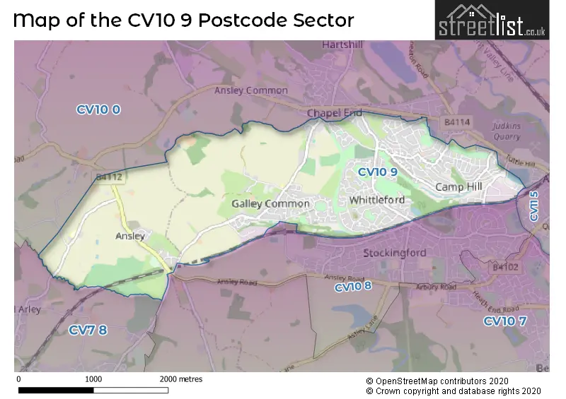
The CV10 9 Postcode shares a border with CV10 0 (NUNEATON, Hartshill, Ridge Lane), CV10 7 (NUNEATON, Astley, Bermuda Park), CV10 8 (NUNEATON), CV7 8 (Keresley End, Fillongley, Arley) and CV11 5 (NUNEATON, Coton).
The sector is within the post town of NUNEATON.
CV10 9 is a postcode sector within the CV10 postcode district which is within the CV Coventry postcode area.
The Royal Mail delivery office for the CV10 9 postal sector is the Nuneaton Delivery Office.
The area of the CV10 9 postcode sector is 3.27 square miles which is 8.48 square kilometres or 2,094.42 square acres.
Waterways within the CV10 9 postcode sector include the Coventry Canal.

Map of the CV10 9 Postcode Sector
Explore the CV10 9 postcode sector by using our free interactive map.
| C | V | 1 | 0 | - | 9 | X | X |
| C | V | 1 | 0 | Space | 9 | Letter | Letter |
Official List of Streets
NUNEATON (138 Streets)
Galley Common (31 Streets)
Ansley (17 Streets)
Unofficial Streets or Alternative Spellings
Weather Forecast for CV10 9
Press Button to Show Forecast for Atherstone
| Time Period | Icon | Description | Temperature | Rain Probability | Wind |
|---|---|---|---|---|---|
| 03:00 to 06:00 | Cloudy | 6.0°C (feels like 4.0°C) | 5.00% | NW 4 mph | |
| 06:00 to 09:00 | Cloudy | 5.0°C (feels like 3.0°C) | 4.00% | N 7 mph | |
| 09:00 to 12:00 | Cloudy | 7.0°C (feels like 4.0°C) | 4.00% | N 9 mph | |
| 12:00 to 15:00 | Cloudy | 9.0°C (feels like 7.0°C) | 7.00% | N 9 mph | |
| 15:00 to 18:00 | Cloudy | 10.0°C (feels like 8.0°C) | 7.00% | N 9 mph | |
| 18:00 to 21:00 | Cloudy | 10.0°C (feels like 8.0°C) | 4.00% | N 7 mph | |
| 21:00 to 00:00 | Partly cloudy (night) | 6.0°C (feels like 5.0°C) | 1.00% | N 4 mph |
Press Button to Show Forecast for Atherstone
| Time Period | Icon | Description | Temperature | Rain Probability | Wind |
|---|---|---|---|---|---|
| 00:00 to 03:00 | Cloudy | 5.0°C (feels like 3.0°C) | 4.00% | NNW 4 mph | |
| 03:00 to 06:00 | Cloudy | 4.0°C (feels like 2.0°C) | 4.00% | WSW 7 mph | |
| 06:00 to 09:00 | Cloudy | 5.0°C (feels like 2.0°C) | 6.00% | W 7 mph | |
| 09:00 to 12:00 | Cloudy | 7.0°C (feels like 5.0°C) | 7.00% | WNW 9 mph | |
| 12:00 to 15:00 | Overcast | 10.0°C (feels like 8.0°C) | 15.00% | NW 9 mph | |
| 15:00 to 18:00 | Cloudy | 10.0°C (feels like 8.0°C) | 9.00% | NW 9 mph | |
| 18:00 to 21:00 | Cloudy | 9.0°C (feels like 7.0°C) | 6.00% | N 7 mph | |
| 21:00 to 00:00 | Partly cloudy (night) | 6.0°C (feels like 4.0°C) | 2.00% | NE 4 mph |
Press Button to Show Forecast for Atherstone
| Time Period | Icon | Description | Temperature | Rain Probability | Wind |
|---|---|---|---|---|---|
| 00:00 to 03:00 | Cloudy | 5.0°C (feels like 3.0°C) | 5.00% | ENE 4 mph | |
| 03:00 to 06:00 | Cloudy | 4.0°C (feels like 2.0°C) | 8.00% | ENE 4 mph | |
| 06:00 to 09:00 | Cloudy | 4.0°C (feels like 2.0°C) | 11.00% | ENE 7 mph | |
| 09:00 to 12:00 | Cloudy | 7.0°C (feels like 5.0°C) | 13.00% | ESE 7 mph | |
| 12:00 to 15:00 | Overcast | 9.0°C (feels like 8.0°C) | 17.00% | ESE 7 mph | |
| 15:00 to 18:00 | Overcast | 10.0°C (feels like 8.0°C) | 18.00% | E 7 mph | |
| 18:00 to 21:00 | Cloudy | 9.0°C (feels like 7.0°C) | 17.00% | E 9 mph | |
| 21:00 to 00:00 | Cloudy | 7.0°C (feels like 5.0°C) | 19.00% | E 9 mph |
Press Button to Show Forecast for Atherstone
| Time Period | Icon | Description | Temperature | Rain Probability | Wind |
|---|---|---|---|---|---|
| 00:00 to 03:00 | Cloudy | 6.0°C (feels like 4.0°C) | 20.00% | E 7 mph | |
| 03:00 to 06:00 | Cloudy | 6.0°C (feels like 3.0°C) | 21.00% | E 7 mph | |
| 06:00 to 09:00 | Cloudy | 6.0°C (feels like 3.0°C) | 19.00% | E 7 mph | |
| 09:00 to 12:00 | Cloudy | 9.0°C (feels like 6.0°C) | 16.00% | E 9 mph | |
| 12:00 to 15:00 | Overcast | 11.0°C (feels like 9.0°C) | 22.00% | E 9 mph | |
| 15:00 to 18:00 | Cloudy | 12.0°C (feels like 9.0°C) | 20.00% | E 9 mph | |
| 18:00 to 21:00 | Cloudy | 10.0°C (feels like 8.0°C) | 15.00% | ENE 9 mph | |
| 21:00 to 00:00 | Cloudy | 9.0°C (feels like 7.0°C) | 17.00% | ENE 9 mph |
Schools and Places of Education Within the CV10 9 Postcode Sector
Arc School Ansley
Other independent special school
Ansley Lane, Nuneaton, Warwickshire, CV10 9ND
Head: Miss Nyree Parker
Ofsted Rating: Good
Inspection: 2022-07-07 (657 days ago)
Website: Visit Arc School Ansley Website
Phone: 01676543810
Number of Pupils: 51
Galley Common Infant School
Community school
Plough Hill Road, Nuneaton, Warwickshire, CV10 9NZ
Head: Mrs Kay Middleton
Ofsted Rating: Good
Inspection: 2023-11-22 (154 days ago)
Website: Visit Galley Common Infant School Website
Phone: 02476392219
Number of Pupils: 167
House Prices in the CV10 9 Postcode Sector
| Type of Property | 2018 Average | 2018 Sales | 2017 Average | 2017 Sales | 2016 Average | 2016 Sales | 2015 Average | 2015 Sales |
|---|---|---|---|---|---|---|---|---|
| Detached | £233,919 | 91 | £217,543 | 79 | £206,600 | 70 | £194,496 | 68 |
| Semi-Detached | £160,863 | 108 | £152,559 | 115 | £145,562 | 118 | £130,482 | 97 |
| Terraced | £130,802 | 94 | £127,602 | 82 | £122,222 | 120 | £113,768 | 84 |
| Flats | £110,370 | 50 | £98,176 | 17 | £95,825 | 20 | £71,147 | 17 |
Important Postcodes CV10 9 in the Postcode Sector
CV10 9AD is the postcode for District Children Services Team, Hilary Road Centre, Hilary Road
CV10 9DN is the postcode for Camp Hill Education Sports & Social, 460 Cedar Road
CV10 9NZ is the postcode for Galley Common Infant School, Plough Hill Road
CV10 9QA is the postcode for CAMP HILL PRIMARY SCHOOL, HOLLYSTITCHES ROAD, NUNEATON, CAMP HILL EARLY YEARS CENTRE (MAIN BUILDING), Camp Hill Nursery School, Hollystitches Road, Warwickshire County Council, Camp Hill Primary School, Hollystitches Road, EARLY YEARS CENTRE (MAIN BUILDING), Camp Hill Nursery School, Hollystitches Road, Camp Hill Primary School, Hollystitches Road, and Early Years Centre, Camp Hill Primary School
| The CV10 9 Sector is within these Local Authorities |
|
|---|---|
| The CV10 9 Sector is within these Counties |
|
| The CV10 9 Sector is within these Water Company Areas |
|