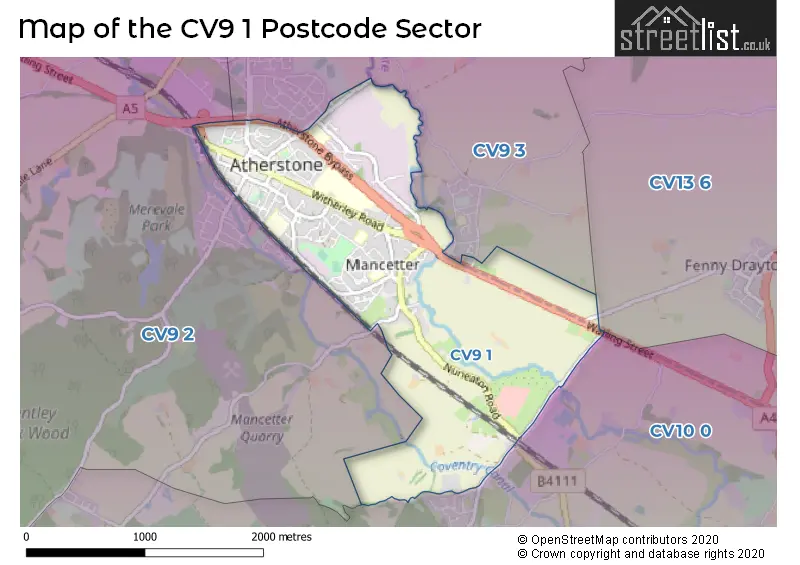
The CV9 1 postcode sector stands on the Leicestershire and Warwickshire border.
Did you know? According to the 2021 Census, the CV9 1 postcode sector is home to a bustling 6,440 residents!
Given that each sector allows for 400 unique postcode combinations. Letters C, I, K, M, O and V are not allowed in the last two letters of a postcode. With 198 postcodes already in use, this leaves 202 units available.
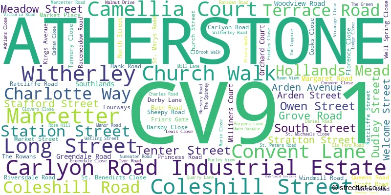
The largest settlements in the CV9 1 postal code are ATHERSTONE and Mancetter.
The CV9 1 Postcode shares a border with CV9 2 (Grendon, ATHERSTONE, Hurley), CV9 3 (ATHERSTONE, Austrey, Sheepy Magna), CV10 0 (NUNEATON, Hartshill, Ridge Lane) and CV13 6 (Stoke Golding, Higham-on-the-Hill, Fenny Drayton).
The sector is within the post town of ATHERSTONE.
CV9 1 is a postcode sector within the CV9 postcode district which is within the CV Coventry postcode area.
The Royal Mail delivery office for the CV9 1 postal sector is the Atherstone Delivery Office.
The area of the CV9 1 postcode sector is 1.98 square miles which is 5.14 square kilometres or 1,270.13 square acres.
The CV9 1 postcode sector is crossed by the A5 Major A road.
Waterways within the CV9 1 postcode sector include the Coventry Canal.

Map of the CV9 1 Postcode Sector
Explore the CV9 1 postcode sector by using our free interactive map.
| C | V | 9 | - | 1 | X | X |
| C | V | 9 | Space | 1 | Letter | Letter |
Official List of Streets
Mancetter (10 Streets)
ATHERSTONE (83 Streets)
Carlyon Road Industrial Estate (4 Streets)
Unofficial Streets or Alternative Spellings
Burbage
WATLING STREETFenny Drayton
DRAYTON LANEHartshill
WOODFORD LANEWitherley
BRIDGE LANE KENNEL LANE RATCLIFFE ROAD ATHERSTONE BYPASS DRUID ARMS COURT FISHERS STILE LEWIS COURT NORTH ARDEN TRAIL RAILWAY TERRACE ST GEORGES ROAD ST. JOHNS COURTYARD THE CLOISTERS WITHERLEY ROAD PAVEMENT WOODHAYES GRANGE WOOLPACK COURT WOOLPACK WAYMancetter
QUARRY LANEATHERSTONE
MARKET PLACE OLD WATLING STREETBentley
COLESHILL ROADWeather Forecast for CV9 1
Press Button to Show Forecast for Atherstone
| Time Period | Icon | Description | Temperature | Rain Probability | Wind |
|---|---|---|---|---|---|
| 15:00 to 18:00 | Cloudy | 9.0°C (feels like 7.0°C) | 10.00% | NNE 7 mph | |
| 18:00 to 21:00 | Cloudy | 8.0°C (feels like 7.0°C) | 8.00% | NNE 4 mph | |
| 21:00 to 00:00 | Cloudy | 6.0°C (feels like 5.0°C) | 7.00% | ENE 4 mph |
Press Button to Show Forecast for Atherstone
| Time Period | Icon | Description | Temperature | Rain Probability | Wind |
|---|---|---|---|---|---|
| 00:00 to 03:00 | Cloudy | 5.0°C (feels like 3.0°C) | 7.00% | E 4 mph | |
| 03:00 to 06:00 | Cloudy | 3.0°C (feels like 2.0°C) | 5.00% | ENE 4 mph | |
| 06:00 to 09:00 | Cloudy | 3.0°C (feels like 2.0°C) | 4.00% | ENE 4 mph | |
| 09:00 to 12:00 | Cloudy | 7.0°C (feels like 5.0°C) | 5.00% | ENE 7 mph | |
| 12:00 to 15:00 | Overcast | 9.0°C (feels like 8.0°C) | 9.00% | ENE 4 mph | |
| 15:00 to 18:00 | Cloudy | 10.0°C (feels like 8.0°C) | 9.00% | ENE 7 mph | |
| 18:00 to 21:00 | Cloudy | 9.0°C (feels like 8.0°C) | 9.00% | ENE 7 mph | |
| 21:00 to 00:00 | Partly cloudy (night) | 6.0°C (feels like 4.0°C) | 7.00% | E 7 mph |
Press Button to Show Forecast for Atherstone
| Time Period | Icon | Description | Temperature | Rain Probability | Wind |
|---|---|---|---|---|---|
| 00:00 to 03:00 | Cloudy | 5.0°C (feels like 2.0°C) | 11.00% | ENE 7 mph | |
| 03:00 to 06:00 | Cloudy | 4.0°C (feels like 2.0°C) | 13.00% | ENE 7 mph | |
| 06:00 to 09:00 | Cloudy | 5.0°C (feels like 2.0°C) | 14.00% | ENE 7 mph | |
| 09:00 to 12:00 | Cloudy | 8.0°C (feels like 5.0°C) | 18.00% | ENE 11 mph | |
| 12:00 to 15:00 | Overcast | 9.0°C (feels like 7.0°C) | 25.00% | ENE 11 mph | |
| 15:00 to 18:00 | Overcast | 10.0°C (feels like 8.0°C) | 23.00% | ENE 11 mph | |
| 18:00 to 21:00 | Cloudy | 10.0°C (feels like 7.0°C) | 20.00% | ENE 11 mph | |
| 21:00 to 00:00 | Cloudy | 8.0°C (feels like 5.0°C) | 20.00% | NE 11 mph |
Press Button to Show Forecast for Atherstone
| Time Period | Icon | Description | Temperature | Rain Probability | Wind |
|---|---|---|---|---|---|
| 00:00 to 03:00 | Light rain | 7.0°C (feels like 4.0°C) | 49.00% | NE 11 mph | |
| 03:00 to 06:00 | Light rain | 7.0°C (feels like 4.0°C) | 52.00% | NE 9 mph | |
| 06:00 to 09:00 | Heavy rain | 7.0°C (feels like 5.0°C) | 76.00% | NNE 9 mph | |
| 09:00 to 12:00 | Heavy rain | 9.0°C (feels like 7.0°C) | 76.00% | ENE 9 mph | |
| 12:00 to 15:00 | Heavy rain shower (day) | 10.0°C (feels like 8.0°C) | 59.00% | N 9 mph | |
| 15:00 to 18:00 | Heavy rain shower (day) | 11.0°C (feels like 9.0°C) | 58.00% | WSW 11 mph | |
| 18:00 to 21:00 | Light rain shower (day) | 11.0°C (feels like 9.0°C) | 39.00% | WSW 9 mph | |
| 21:00 to 00:00 | Clear night | 8.0°C (feels like 6.0°C) | 9.00% | SSE 7 mph |
Schools and Places of Education Within the CV9 1 Postcode Sector
Atherstone Nursery School
Local authority nursery school
Kings Avenue, Atherstone, Warwickshire, CV9 1LF
Head: Mrs Nicola Burton
Ofsted Rating: Outstanding
Inspection: 2019-01-09 (1933 days ago)
Website: Visit Atherstone Nursery School Website
Phone: 01827794164
Number of Pupils: 63
Outwoods Primary School
Community school
Southlands, Atherstone, Warwickshire, CV9 1EH
Head: Mrs Sally Taylor
Ofsted Rating: Good
Inspection: 2023-07-12 (288 days ago)
Website: Visit Outwoods Primary School Website
Phone: 01827712372
Number of Pupils: 420
Racemeadow Primary Academy
Academy sponsor led
Ratcliffe Road, Atherstone, Warwickshire, CV9 1LT
Head: Mrs Joanna Collinson
Ofsted Rating: Good
Inspection: 2023-03-14 (408 days ago)
Website: Visit Racemeadow Primary Academy Website
Phone: 01827713284
Number of Pupils: 350
St Benedict's Catholic Primary Academy
Academy converter
Church Walk, Atherstone, Warwickshire, CV9 1PS
Head: Mrs Paula Parker
Ofsted Rating: Good
Inspection: 2023-06-14 (316 days ago)
Website: Visit St Benedict's Catholic Primary Academy Website
Phone: 01827712320
Number of Pupils: 187
The Queen Elizabeth Academy
Academy sponsor led
Witherley Road, Atherstone, Warwickshire, CV9 1LZ
Head: Mr Neil Harding
Ofsted Rating: Good
Inspection: 2022-06-29 (666 days ago)
Website: Visit The Queen Elizabeth Academy Website
Phone: 01827712477
Number of Pupils: 701
House Prices in the CV9 1 Postcode Sector
| Type of Property | 2018 Average | 2018 Sales | 2017 Average | 2017 Sales | 2016 Average | 2016 Sales | 2015 Average | 2015 Sales |
|---|---|---|---|---|---|---|---|---|
| Detached | £324,129 | 19 | £270,966 | 16 | £252,537 | 26 | £247,821 | 28 |
| Semi-Detached | £185,994 | 37 | £204,393 | 22 | £163,810 | 24 | £152,667 | 37 |
| Terraced | £161,563 | 22 | £139,842 | 31 | £128,987 | 32 | £120,324 | 23 |
| Flats | £102,690 | 10 | £116,805 | 19 | £128,573 | 33 | £127,426 | 51 |
Important Postcodes CV9 1 in the Postcode Sector
CV9 1AB is the postcode for North Warwickshire Borough Council, Old Bank House, 129 Long Street, and Old Bank House, Long Street
CV9 1AF is the postcode for Arden Centre, 120 Long Street
CV9 1AU is the postcode for Clock, 32 Long Street
CV9 1AX is the postcode for Atherstone Library, Long Street, MEMORIAL HALL, Atherstone Leisure Complex, Long Street, Atherstone Leisure Complex, Long Street, and Atherstone Clinic, Long Street
CV9 1BD is the postcode for North Warwickshire Borough Council
CV9 1DE is the postcode for North Warwickshire Borough Council, The Council House, South Street
CV9 1DZ is the postcode for 55 South Street
CV9 1EH is the postcode for UPPER, Outwoods Primary School, Southlands, (FORMERLY OAKFIELD JUNIOR), Outwoods Primary School, Southlands, LOWER, Outwoods Primary School, Southlands, and Oakfield Junior School, Southlands
CV9 1EU is the postcode for The Atherstone Surgery, 1 Ratcliffe Road
CV9 1HF is the postcode for Atherstone Police Station, Warwickshire Police
CV9 1HH is the postcode for THE OFFICE BUILDING, North Warwickshire Borough Council, The Depot, Sheepy Road, and North Warwickshire Borough Council, The Depot, Sheepy Road
CV9 1JZ is the postcode for PARENTS CENTRE, Atherstone Early Years Centre, Kings Avenue
CV9 1LF is the postcode for Atherstone College, Ratcliffe Road
CV9 1LT is the postcode for RACEMEADOW PRIMARY ACADEMY, Racemeadow Primary School, Ratcliffe Road, Racemeadow Primary Academy, Ratcliffe Road, RACEMEADOW PRIMARY ACADEMY, Racemeadow Primary Academy, Ratcliffe Road, and RACEMEADOW PRIMARY ACADEMY, RATCLIFFE ROAD, ATHERSTONE
CV9 1LZ is the postcode for SPORTS HALL, Queen Elizabeth Academy, Witherley Road, MAIN BUILDING, Queen Elizabeth School & Sports College, Witherley Road, Queen Elizabeth School & Sports College (Lower School), Long Street, UPPER SCHOOL MAIN BUILDING, Queen Elizabeth School & Sports College, Witherley Road, LOWER SCHOOL MAIN BUILDING, Queen Elizabeth School & Sports College, Witherley Road, and TEACHING BLOCK, Queen Elizabeth Academy, Witherley Road
CV9 1PS is the postcode for St. Benedicts RC School, Church Walk
| The CV9 1 Sector is within these Local Authorities |
|
|---|---|
| The CV9 1 Sector is within these Counties |
|
| The CV9 1 Sector is within these Water Company Areas |
|