The CW10 postcode district is a postal district located in the CW Crewe postcode area with a population of 15,609 residents according to the 2021 England and Wales Census.
The area of the CW10 postcode district is 20.84 square miles which is 53.98 square kilometres or 13,339.72 acres.
Currently, the CW10 district has about 442 postcode units spread across 2 geographic postcode sectors.
Given that each sector allows for 400 unique postcode combinations, the district has a capacity of 800 postcodes. With 442 postcodes already in use, this leaves 358 units available.
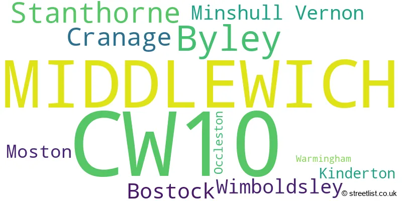
The largest settlement in the CW10 postal code is MIDDLEWICH followed by Byley, and Bostock.
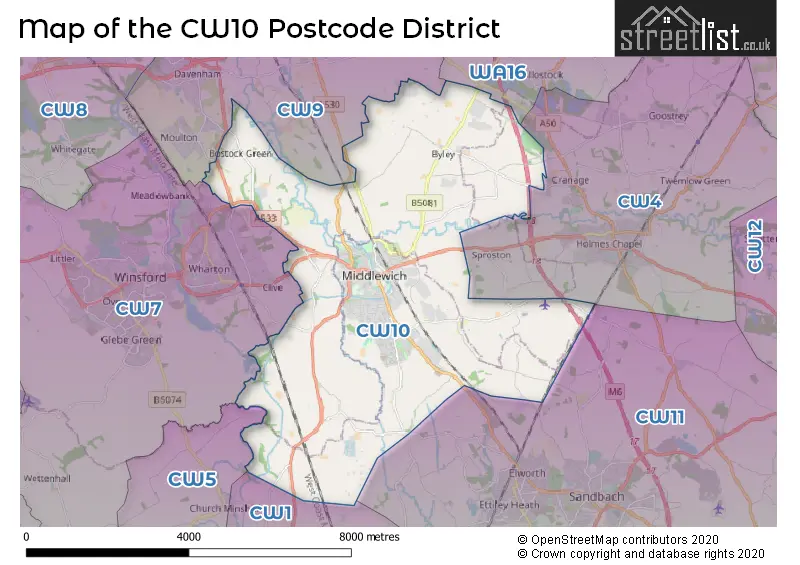
The CW10 Postcode shares a border with CW1 (CREWE, Haslington, Leighton), CW11 (SANDBACH, Elworth, Winterley), CW4 (Holmes Chapel, Goostrey, Cranage), CW5 (NANTWICH, Willaston, Stapeley), CW7 (WINSFORD, Winsford Industrial Estate, Wettenhall) and CW9 (NORTHWICH, Rudheath, Davenham).
The primary settlement in the CW10 postcode district is Middlewich, located in the county of Cheshire, England. Other significant settlements in this district include Kinderton, Minshull Vernon, Moston, Occleston, Stanthorne, Warmingham, and Wimboldsley. The most significant post town in this district is Middlewich.
For the district CW10, we have data on 2 postcode sectors. Here's a breakdown: The sector CW10 0, covers Middlewich in Cheshire. The sector CW10 9, covers Middlewich and Byley in Cheshire.

Map of the CW10 Postcode District
Explore the CW10 postcode district by using our free interactive map.
When it comes to local government, postal geography often disregards political borders. However, for a breakdown in the CW10 District: the district mostly encompasses the Cheshire East (B) (393 postcodes), and finally, the Cheshire West and Chester (B) area (60 postcodes).
Weather Forecast for CW10
Press Button to Show Forecast for Middlewich
| Time Period | Icon | Description | Temperature | Rain Probability | Wind |
|---|---|---|---|---|---|
| 00:00 to 03:00 | Partly cloudy (night) | 6.0°C (feels like 3.0°C) | 7.00% | NW 11 mph | |
| 03:00 to 06:00 | Partly cloudy (night) | 5.0°C (feels like 1.0°C) | 7.00% | NW 11 mph | |
| 06:00 to 09:00 | Sunny day | 4.0°C (feels like 1.0°C) | 3.00% | NW 9 mph | |
| 09:00 to 12:00 | Partly cloudy (day) | 8.0°C (feels like 4.0°C) | 3.00% | NW 16 mph | |
| 12:00 to 15:00 | Cloudy | 10.0°C (feels like 6.0°C) | 7.00% | NW 18 mph | |
| 15:00 to 18:00 | Cloudy | 10.0°C (feels like 7.0°C) | 11.00% | NW 16 mph | |
| 18:00 to 21:00 | Cloudy | 8.0°C (feels like 6.0°C) | 6.00% | NW 11 mph | |
| 21:00 to 00:00 | Partly cloudy (night) | 6.0°C (feels like 4.0°C) | 4.00% | N 4 mph |
Press Button to Show Forecast for Middlewich
| Time Period | Icon | Description | Temperature | Rain Probability | Wind |
|---|---|---|---|---|---|
| 00:00 to 03:00 | Clear night | 3.0°C (feels like 2.0°C) | 1.00% | NNE 4 mph | |
| 03:00 to 06:00 | Clear night | 1.0°C (feels like 0.0°C) | 3.00% | NE 2 mph | |
| 06:00 to 09:00 | Partly cloudy (day) | 3.0°C (feels like 1.0°C) | 6.00% | SSW 2 mph | |
| 09:00 to 12:00 | Cloudy | 8.0°C (feels like 6.0°C) | 7.00% | SW 7 mph | |
| 12:00 to 15:00 | Overcast | 10.0°C (feels like 9.0°C) | 14.00% | W 9 mph | |
| 15:00 to 18:00 | Light rain | 10.0°C (feels like 8.0°C) | 48.00% | W 11 mph | |
| 18:00 to 21:00 | Light rain | 10.0°C (feels like 7.0°C) | 52.00% | W 11 mph | |
| 21:00 to 00:00 | Heavy rain | 9.0°C (feels like 6.0°C) | 71.00% | W 11 mph |
Press Button to Show Forecast for Middlewich
| Time Period | Icon | Description | Temperature | Rain Probability | Wind |
|---|---|---|---|---|---|
| 00:00 to 03:00 | Light rain | 9.0°C (feels like 6.0°C) | 48.00% | WNW 13 mph | |
| 03:00 to 06:00 | Overcast | 9.0°C (feels like 5.0°C) | 16.00% | WNW 16 mph | |
| 06:00 to 09:00 | Overcast | 8.0°C (feels like 5.0°C) | 13.00% | NW 13 mph | |
| 09:00 to 12:00 | Partly cloudy (day) | 10.0°C (feels like 6.0°C) | 6.00% | NW 18 mph | |
| 12:00 to 15:00 | Cloudy | 11.0°C (feels like 8.0°C) | 10.00% | NW 18 mph | |
| 15:00 to 18:00 | Cloudy | 11.0°C (feels like 8.0°C) | 5.00% | NW 18 mph | |
| 18:00 to 21:00 | Cloudy | 10.0°C (feels like 8.0°C) | 5.00% | NW 13 mph | |
| 21:00 to 00:00 | Partly cloudy (night) | 8.0°C (feels like 6.0°C) | 2.00% | NNW 9 mph |
Press Button to Show Forecast for Middlewich
| Time Period | Icon | Description | Temperature | Rain Probability | Wind |
|---|---|---|---|---|---|
| 00:00 to 03:00 | Partly cloudy (night) | 7.0°C (feels like 5.0°C) | 2.00% | N 7 mph | |
| 03:00 to 06:00 | Clear night | 5.0°C (feels like 3.0°C) | 1.00% | NNE 4 mph | |
| 06:00 to 09:00 | Sunny day | 5.0°C (feels like 3.0°C) | 2.00% | NNE 4 mph | |
| 09:00 to 12:00 | Sunny day | 9.0°C (feels like 8.0°C) | 1.00% | N 4 mph | |
| 12:00 to 15:00 | Sunny day | 11.0°C (feels like 10.0°C) | 2.00% | NNW 7 mph | |
| 15:00 to 18:00 | Partly cloudy (day) | 13.0°C (feels like 11.0°C) | 1.00% | NW 7 mph | |
| 18:00 to 21:00 | Sunny day | 11.0°C (feels like 10.0°C) | 1.00% | NW 7 mph | |
| 21:00 to 00:00 | Clear night | 8.0°C (feels like 6.0°C) | 1.00% | NW 4 mph |
Where is the CW10 Postcode District?
The postcode district CW10 is located in the town of Middlewich. Middlewich is surrounded by several nearby towns, including Winsford located to the West (4.05 miles away), Sandbach located to the South East (4.23 miles away), Northwich located to the North West (5.19 miles away), Crewe located to the South (6.86 miles away), Knutsford located to the North East (8.63 miles away), and Congleton located to the East (10.46 miles away). Additionally, Middlewich is approximately 152.02 miles away from the center of London.
The district is within the post town of MIDDLEWICH.
The sector has postcodes within the nation of England.
The CW10 Postcode District is covers the following regions.
- Cheshire East - Cheshire - North West (England)
- Cheshire West and Chester - Cheshire - North West (England)
| Postcode Sector | Delivery Office |
|---|---|
| CW10 0 | Winsford Delivery Office |
| CW10 9 | Winsford Delivery Office |
| C | W | 1 | 0 | - | X | X | X |
| C | W | 1 | 0 | Space | Numeric | Letter | Letter |
Current Monthly Rental Prices
| # Bedrooms | Min Price | Max Price | Avg Price |
|---|---|---|---|
| 1 | £525 | £525 | £525 |
| 2 | £595 | £1,500 | £878 |
| 3 | £850 | £950 | £900 |
| 4 | £1,400 | £1,500 | £1,450 |
Current House Prices
| # Bedrooms | Min Price | Max Price | Avg Price |
|---|---|---|---|
| £10,000 | £10,000 | £10,000 | |
| 1 | £119,950 | £183,499 | £147,737 |
| 2 | £72,000 | £335,000 | £181,047 |
| 3 | £160,000 | £595,000 | £274,560 |
| 4 | £240,000 | £995,000 | £399,432 |
| 5 | £290,000 | £399,950 | £326,650 |
| 6 | £254,000 | £1,250,000 | £840,800 |
Estate Agents who Operate in the CW10 District
| Logo | Name | Brand Name | Address | Contact Number | Total Properties |
|---|---|---|---|---|---|
 | Middlewich | Coulby Conduct | 34 Wheelock Street, Middlewich, CW10 9AB | 01606 668824 | 24 |
 | Middlewich | Townbridge Estate Agents | 1 St. Michaels Way, Middlewich, CW10 9DX | 01606 539837 | 18 |
 | Middlewich | Umbrella Homes | 17 Wheelock Street, Middlewich, CW10 9AG | 01606 663938 | 10 |
 | Holmes Chapel | Reeds Rains | The Precinct, 21 London Road, Holmes Chapel, CW4 7AP | 01477 412205 | 7 |
 | covering Crewe | Purplebricks | Suite 7 First Floor Cranmore Drive Shirley Solihull B90 4RZ | 020 3907 2969 | 5 |
| Type of Property | 2018 Average | 2018 Sales | 2017 Average | 2017 Sales | 2016 Average | 2016 Sales | 2015 Average | 2015 Sales |
|---|---|---|---|---|---|---|---|---|
| Detached | £245,137 | 144 | £239,124 | 151 | £246,186 | 130 | £235,089 | 155 |
| Semi-Detached | £159,108 | 99 | £160,023 | 118 | £150,785 | 100 | £142,381 | 90 |
| Terraced | £159,313 | 69 | £132,156 | 76 | £127,586 | 74 | £133,137 | 86 |
| Flats | £115,222 | 9 | £106,170 | 10 | £160,556 | 9 | £107,778 | 9 |
Hotels within the Postcode Area
We found 5 hotels and guest houses within the CW10 postcode area
Hopley House Bed & Breakfast
Nantwich Road, Wimboldsley, Middlewich, middlewich, CW10 0LN.
View details