The CW4 postcode district is a postal district located in the CW Crewe postcode area with a population of 10,867 residents according to the 2021 England and Wales Census.
The area of the CW4 postcode district is 14.26 square miles which is 36.93 square kilometres or 9,125.37 acres.
Currently, the CW4 district has about 336 postcode units spread across 2 geographic postcode sectors.
Given that each sector allows for 400 unique postcode combinations, the district has a capacity of 800 postcodes. With 336 postcodes already in use, this leaves 464 units available.
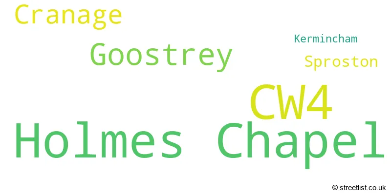
The largest settlement in the CW4 postal code is Holmes Chapel followed by Goostrey, and Cranage.
The CW4 Postcode shares a border with CW10 (MIDDLEWICH, Byley, Bostock), WA16 (KNUTSFORD, Mobberley, High Legh), CW12 (CONGLETON, Somerford, Eaton) and SK11 (MACCLESFIELD, Gawsworth, Chelford).
The primary settlement in the CW4 postcode district is Holmes Chapel, located in Cheshire. The most significant post town in this district is Crewe, also in Cheshire. Other significant settlements within the CW4 postcode district include Sproston, Cranage, Goostrey, and Kermincham.
For the district CW4, we have data on 2 postcode sectors. Here's a breakdown: The sector CW4 7, covers Holmes Chapel in Cheshire. The sector CW4 8, covers Holmes Chapel and Goostrey and Cranage in Cheshire.

Map of the CW4 Postcode District
Explore the CW4 postcode district by using our free interactive map.
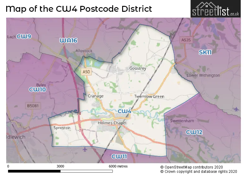
When it comes to local government, postal geography often disregards political borders. However, for a breakdown in the CW4 District: the district mostly encompasses the Cheshire East (B) (329 postcodes), and finally, the Cheshire West and Chester (B) area (16 postcodes).
Weather Forecast for CW4
Press Button to Show Forecast for Holmes Chapel
| Time Period | Icon | Description | Temperature | Rain Probability | Wind |
|---|---|---|---|---|---|
| 09:00 to 12:00 | Cloudy | 8.0°C (feels like 4.0°C) | 6.00% | NW 16 mph | |
| 12:00 to 15:00 | Cloudy | 9.0°C (feels like 6.0°C) | 7.00% | NW 18 mph | |
| 15:00 to 18:00 | Cloudy | 9.0°C (feels like 6.0°C) | 13.00% | NW 13 mph | |
| 18:00 to 21:00 | Partly cloudy (day) | 8.0°C (feels like 5.0°C) | 4.00% | NW 11 mph | |
| 21:00 to 00:00 | Partly cloudy (night) | 5.0°C (feels like 3.0°C) | 5.00% | NNW 4 mph |
Press Button to Show Forecast for Holmes Chapel
| Time Period | Icon | Description | Temperature | Rain Probability | Wind |
|---|---|---|---|---|---|
| 00:00 to 03:00 | Clear night | 2.0°C (feels like 0.0°C) | 5.00% | NNE 4 mph | |
| 03:00 to 06:00 | Clear night | 1.0°C (feels like -1.0°C) | 5.00% | NNE 2 mph | |
| 06:00 to 09:00 | Partly cloudy (day) | 3.0°C (feels like 1.0°C) | 6.00% | SSW 2 mph | |
| 09:00 to 12:00 | Cloudy | 8.0°C (feels like 6.0°C) | 7.00% | WSW 4 mph | |
| 12:00 to 15:00 | Overcast | 10.0°C (feels like 8.0°C) | 14.00% | W 9 mph | |
| 15:00 to 18:00 | Light rain | 10.0°C (feels like 8.0°C) | 48.00% | W 11 mph | |
| 18:00 to 21:00 | Light rain | 9.0°C (feels like 7.0°C) | 52.00% | W 11 mph | |
| 21:00 to 00:00 | Heavy rain | 8.0°C (feels like 5.0°C) | 71.00% | W 11 mph |
Press Button to Show Forecast for Holmes Chapel
| Time Period | Icon | Description | Temperature | Rain Probability | Wind |
|---|---|---|---|---|---|
| 00:00 to 03:00 | Light rain | 9.0°C (feels like 6.0°C) | 48.00% | WNW 13 mph | |
| 03:00 to 06:00 | Overcast | 8.0°C (feels like 5.0°C) | 16.00% | WNW 13 mph | |
| 06:00 to 09:00 | Cloudy | 8.0°C (feels like 5.0°C) | 11.00% | NW 13 mph | |
| 09:00 to 12:00 | Light rain shower (day) | 9.0°C (feels like 6.0°C) | 28.00% | NW 18 mph | |
| 12:00 to 15:00 | Overcast | 11.0°C (feels like 7.0°C) | 10.00% | NW 18 mph | |
| 15:00 to 18:00 | Cloudy | 11.0°C (feels like 8.0°C) | 5.00% | NW 16 mph | |
| 18:00 to 21:00 | Partly cloudy (day) | 10.0°C (feels like 8.0°C) | 3.00% | NW 13 mph | |
| 21:00 to 00:00 | Partly cloudy (night) | 8.0°C (feels like 6.0°C) | 2.00% | NNW 9 mph |
Press Button to Show Forecast for Holmes Chapel
| Time Period | Icon | Description | Temperature | Rain Probability | Wind |
|---|---|---|---|---|---|
| 00:00 to 03:00 | Partly cloudy (night) | 6.0°C (feels like 4.0°C) | 2.00% | N 7 mph | |
| 03:00 to 06:00 | Clear night | 4.0°C (feels like 2.0°C) | 1.00% | N 4 mph | |
| 06:00 to 09:00 | Sunny day | 5.0°C (feels like 3.0°C) | 2.00% | N 4 mph | |
| 09:00 to 12:00 | Sunny day | 9.0°C (feels like 7.0°C) | 1.00% | N 4 mph | |
| 12:00 to 15:00 | Partly cloudy (day) | 11.0°C (feels like 10.0°C) | 2.00% | NW 7 mph | |
| 15:00 to 18:00 | Partly cloudy (day) | 12.0°C (feels like 11.0°C) | 1.00% | NW 7 mph | |
| 18:00 to 21:00 | Sunny day | 11.0°C (feels like 10.0°C) | 1.00% | NW 7 mph | |
| 21:00 to 00:00 | Clear night | 7.0°C (feels like 6.0°C) | 1.00% | NW 4 mph |
Where is the CW4 Postcode District?
The data shows that the CW4 postcode district is located in Crewe, a town in Cheshire. It is surrounded by several nearby towns, including Middlewich, Sandbach, Knutsford, Northwich, Alderley Edge, Congleton, and Winsford. Additionally, the distance from Crewe to the center of London is approximately 150.7 miles.
The district is within the post town of CREWE.
The sector has postcodes within the nation of England.
The CW4 Postcode District is covers the following regions.
- Cheshire East - Cheshire - North West (England)
- Cheshire West and Chester - Cheshire - North West (England)
| Postcode Sector | Delivery Office |
|---|---|
| CW4 7 | Congleton Delivery Office |
| CW4 8 | Congleton Delivery Office |
| C | W | 4 | - | X | X | X |
| C | W | 4 | Space | Numeric | Letter | Letter |
Tourist Attractions within the Postcode Area
We found 1 visitor attractions within the CW4 postcode area
| Jodrell Bank Discovery Centre |
|---|
| Visitor Centres |
| Heritage / Visitor Centre |
| View Jodrell Bank Discovery Centre on Google Maps |
Current Monthly Rental Prices
| # Bedrooms | Min Price | Max Price | Avg Price |
|---|---|---|---|
| 1 | £725 | £725 | £725 |
| 3 | £1,150 | £1,450 | £1,275 |
| 4 | £1,500 | £1,500 | £1,500 |
Current House Prices
| # Bedrooms | Min Price | Max Price | Avg Price |
|---|---|---|---|
| £249,950 | £10,000,000 | £3,566,650 | |
| 1 | £90,000 | £115,000 | £102,000 |
| 2 | £98,000 | £525,000 | £238,608 |
| 3 | £63,750 | £980,000 | £397,703 |
| 4 | £375,000 | £1,150,000 | £620,500 |
| 5 | £450,000 | £2,500,000 | £1,069,000 |
| 6 | £1,795,000 | £2,250,000 | £2,098,333 |
Estate Agents who Operate in the CW4 District
| Logo | Name | Brand Name | Address | Contact Number | Total Properties |
|---|---|---|---|---|---|
 | Holmes Chapel | Gascoigne Halman | 14 The Square, Holmes Chapel, CW4 7AB | 01477 418108 | 29 |
 | Holmes Chapel | Latham Estates Ltd | 16 The Square, Holmes Chapel, CW4 7AB | 01477 412185 | 17 |
 | Holmes Chapel | Reeds Rains | The Precinct, 21 London Road, Holmes Chapel, CW4 7AP | 01477 412205 | 11 |
 | Knutsford | Stuart Rushton & Co | 35 King Street, Knutsford, Cheshire, WA16 6DW | 01565 746768 | 5 |
 | Knutsford | Savills | 35/37 Princess Street, Knutsford, WA16 6BP | 01560 337674 | 5 |
| Type of Property | 2018 Average | 2018 Sales | 2017 Average | 2017 Sales | 2016 Average | 2016 Sales | 2015 Average | 2015 Sales |
|---|---|---|---|---|---|---|---|---|
| Detached | £423,684 | 148 | £442,561 | 155 | £418,594 | 125 | £358,551 | 129 |
| Semi-Detached | £240,415 | 65 | £235,336 | 65 | £241,020 | 67 | £217,001 | 48 |
| Terraced | £175,609 | 42 | £155,014 | 38 | £201,706 | 24 | £173,427 | 32 |
| Flats | £109,260 | 21 | £116,100 | 25 | £116,569 | 18 | £103,304 | 13 |
Hotels within the Postcode Area
We found 2 hotels and guest houses within the CW4 postcode area
The Vicarage Freehouse & Rooms
Knutsford Road, Cranage Holmes Chapel, Holmes Chapel, holmes-chapel, CW4 8EF.
View details