The DA1 2 postcode sector is within the county of Kent.
Did you know? According to the 2021 Census, the DA1 2 postcode sector is home to a bustling 13,004 residents!
Given that each sector allows for 400 unique postcode combinations. Letters C, I, K, M, O and V are not allowed in the last two letters of a postcode. With 234 postcodes already in use, this leaves 166 units available.
The largest settlements in the DA1 2 postal code are DARTFORD and WILMINGTON .
The DA1 2 Postcode shares a border with DA1 3 (DARTFORD , CRAYFORD ), DA1 5 (DARTFORD ), DA2 7 (WILMINGTON, DARENTH, HAWLEY) and DA1 1 (DARTFORD , WILMINGTON ).
The sector is within the post town of DARTFORD.
DA1 2 is a postcode sector within the DA1 postcode district which is within the DA Dartford postcode area.
The Royal Mail delivery office for the DA1 2 postal sector is the Dartford Delivery Office.
The area of the DA1 2 postcode sector is 1.24 square miles which is 3.21 square kilometres or 793.01 square acres.
The DA1 2 postcode sector is crossed by the A2 Major A road.

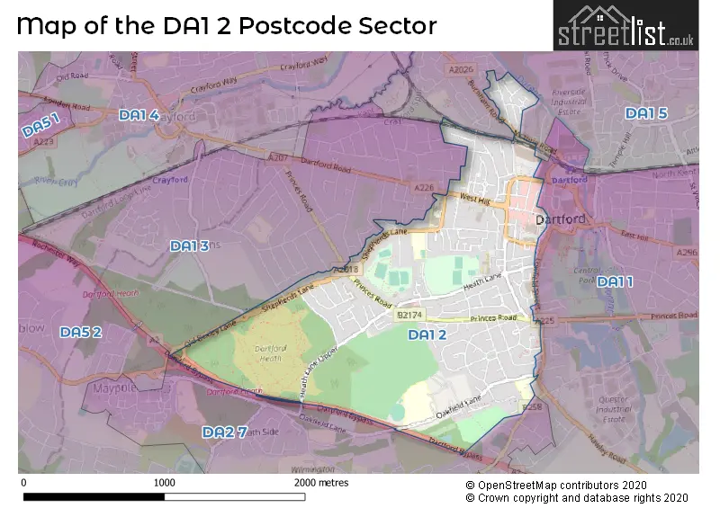
Map of the DA1 2 Postcode Sector
Explore the DA1 2 postcode sector by using our free interactive map.
| D | A | 1 | - | 2 | X | X |
| D | A | 1 | Space | 2 | Letter | Letter |
Official List of Streets
DARTFORD (100 Streets)
Unofficial Streets or Alternative Spellings
DARTFORD
BLENHEIM CLOSE BURNHAM ROAD CHRISTCHURCH ROAD GLOUCESTER ROAD HALLFORD WAY HAVELOCK ROAD HEATHER DRIVE HIGH STREET HOME GARDENS HYTHE STREET KNOLE ROAD LAWSON GARDENS LAWSON ROAD LOWFIELD STREET RIVERSIDE WHARF SOMERSET ROAD SPRING VALE SOUTH ST. JAMES PLACE VAUXHALL PLACE VICTORIA ROAD ALEXANDRA TERRACE DARTFORD BYPASS HEATH LANE (UPPER) HEATH LANE UPPER HIGHFIELD ROAD NORTH HIGHFIELD ROAD SOUTH LOAM COURT ROSEDENE CLOSE THATCHER COURT THE CLOISTERS THE PRIORY CENTRE TIN BRIDGE TWISLETON COURT WATERBRIDGE COURT WESTVIEW COURT ZION COTTAGESBEXLEY
OLD BEXLEY LANECrayford
ROCHESTER WAYWeather Forecast for DA1 2
Press Button to Show Forecast for Dartford
| Time Period | Icon | Description | Temperature | Rain Probability | Wind |
|---|---|---|---|---|---|
| 06:00 to 09:00 | Cloudy | 7.0°C (feels like 5.0°C) | 11.00% | WSW 7 mph | |
| 09:00 to 12:00 | Cloudy | 10.0°C (feels like 8.0°C) | 7.00% | W 9 mph | |
| 12:00 to 15:00 | Overcast | 11.0°C (feels like 8.0°C) | 15.00% | W 11 mph | |
| 15:00 to 18:00 | Light rain | 12.0°C (feels like 9.0°C) | 45.00% | WNW 9 mph | |
| 18:00 to 21:00 | Cloudy | 10.0°C (feels like 8.0°C) | 12.00% | N 7 mph | |
| 21:00 to 00:00 | Cloudy | 8.0°C (feels like 6.0°C) | 8.00% | ENE 7 mph |
Press Button to Show Forecast for Dartford
| Time Period | Icon | Description | Temperature | Rain Probability | Wind |
|---|---|---|---|---|---|
| 00:00 to 03:00 | Cloudy | 7.0°C (feels like 5.0°C) | 6.00% | NE 4 mph | |
| 03:00 to 06:00 | Cloudy | 6.0°C (feels like 4.0°C) | 5.00% | NE 4 mph | |
| 06:00 to 09:00 | Cloudy | 6.0°C (feels like 4.0°C) | 5.00% | NE 4 mph | |
| 09:00 to 12:00 | Cloudy | 8.0°C (feels like 6.0°C) | 5.00% | ENE 7 mph | |
| 12:00 to 15:00 | Overcast | 10.0°C (feels like 8.0°C) | 11.00% | E 7 mph | |
| 15:00 to 18:00 | Overcast | 10.0°C (feels like 9.0°C) | 15.00% | E 7 mph | |
| 18:00 to 21:00 | Cloudy | 10.0°C (feels like 8.0°C) | 13.00% | E 9 mph | |
| 21:00 to 00:00 | Cloudy | 8.0°C (feels like 6.0°C) | 13.00% | E 7 mph |
Press Button to Show Forecast for Dartford
| Time Period | Icon | Description | Temperature | Rain Probability | Wind |
|---|---|---|---|---|---|
| 00:00 to 03:00 | Light rain | 8.0°C (feels like 5.0°C) | 46.00% | E 7 mph | |
| 03:00 to 06:00 | Light rain | 7.0°C (feels like 5.0°C) | 48.00% | ENE 7 mph | |
| 06:00 to 09:00 | Overcast | 7.0°C (feels like 5.0°C) | 21.00% | ENE 9 mph | |
| 09:00 to 12:00 | Cloudy | 10.0°C (feels like 8.0°C) | 20.00% | E 9 mph | |
| 12:00 to 15:00 | Cloudy | 12.0°C (feels like 10.0°C) | 16.00% | E 9 mph | |
| 15:00 to 18:00 | Light rain | 13.0°C (feels like 11.0°C) | 50.00% | E 11 mph | |
| 18:00 to 21:00 | Light rain | 12.0°C (feels like 10.0°C) | 51.00% | E 11 mph | |
| 21:00 to 00:00 | Light rain | 11.0°C (feels like 9.0°C) | 51.00% | ENE 9 mph |
Press Button to Show Forecast for Dartford
| Time Period | Icon | Description | Temperature | Rain Probability | Wind |
|---|---|---|---|---|---|
| 00:00 to 03:00 | Light rain | 10.0°C (feels like 9.0°C) | 54.00% | E 9 mph | |
| 03:00 to 06:00 | Light rain shower (night) | 10.0°C (feels like 8.0°C) | 42.00% | E 9 mph | |
| 06:00 to 09:00 | Light rain | 10.0°C (feels like 8.0°C) | 51.00% | ESE 9 mph | |
| 09:00 to 12:00 | Light rain shower (day) | 11.0°C (feels like 9.0°C) | 46.00% | SSE 9 mph | |
| 12:00 to 15:00 | Light rain shower (day) | 13.0°C (feels like 11.0°C) | 42.00% | S 11 mph | |
| 15:00 to 18:00 | Heavy rain shower (day) | 14.0°C (feels like 12.0°C) | 53.00% | S 11 mph | |
| 18:00 to 21:00 | Partly cloudy (day) | 13.0°C (feels like 11.0°C) | 14.00% | SSW 9 mph | |
| 21:00 to 00:00 | Partly cloudy (night) | 11.0°C (feels like 10.0°C) | 7.00% | SSW 7 mph |
Schools and Places of Education Within the DA1 2 Postcode Sector
Dartford Grammar School
Academy converter
West Hill, Dartford, Kent, DA1 2HW
Head: Mr Julian Metcalf
Ofsted Rating: Outstanding
Inspection: 2022-12-07 (505 days ago)
Website: Visit Dartford Grammar School Website
Phone: 01322223039
Number of Pupils: 1516
Dartford Grammar School for Girls
Academy converter
Shepherds Lane, Dartford, Kent, DA1 2NT
Head: Mrs Sharon Pritchard
Ofsted Rating: Outstanding
Inspection: 2021-10-20 (918 days ago)
Website: Visit Dartford Grammar School for Girls Website
Phone: 01322223123
Number of Pupils: 1248
Dartford Science & Technology College
Foundation school
Heath Lane, Dartford, Kent, DA1 2LY
Head: Miss Joanne Sangster
Ofsted Rating: Good
Inspection: 2022-03-16 (771 days ago)
Website: Visit Dartford Science & Technology College Website
Phone: 01322224309
Number of Pupils: 876
North Kent College
Further education
Oakfield Lane, Dartford, Kent, DA1 2JT
Head: Mr David Gleed
Ofsted Rating: Good
Inspection: 2017-11-30 (2338 days ago)
Website: Visit North Kent College Website
Phone: 01322629400
Number of Pupils: 0
Oakfield Primary Academy
Academy converter
Oakfield Lane, Dartford, Kent, DA1 2SW
Head: Mrs Rajinder Kaur-Gill
Ofsted Rating: Good
Inspection: 2021-10-06 (932 days ago)
Website: Visit Oakfield Primary Academy Website
Phone: 01322220831
Number of Pupils: 719
Our Lady's Catholic Primary School, Dartford
Voluntary aided school
King Edward Avenue, Dartford, Kent, DA1 2HX
Head: Miss Isabel Quinn
Ofsted Rating: Good
Inspection: 2020-02-12 (1534 days ago)
Website: Visit Our Lady's Catholic Primary School, Dartford Website
Phone: 01322222759
Number of Pupils: 217
Westgate Primary School
Academy sponsor led
Summerhill Road, Dartford, Kent, DA1 2LP
Head: Mrs Laura Crosley
Ofsted Rating: Good
Inspection: 2019-03-06 (1877 days ago)
Website: Visit Westgate Primary School Website
Phone: 01322223382
Number of Pupils: 210
House Prices in the DA1 2 Postcode Sector
| Type of Property | 2018 Average | 2018 Sales | 2017 Average | 2017 Sales | 2016 Average | 2016 Sales | 2015 Average | 2015 Sales |
|---|---|---|---|---|---|---|---|---|
| Detached | £573,333 | 6 | £533,364 | 11 | £419,800 | 5 | £438,845 | 10 |
| Semi-Detached | £364,760 | 45 | £363,592 | 38 | £368,832 | 34 | £326,697 | 33 |
| Terraced | £298,257 | 79 | £311,162 | 90 | £297,069 | 91 | £255,921 | 77 |
| Flats | £238,666 | 79 | £225,421 | 98 | £191,444 | 167 | £166,940 | 106 |
Important Postcodes DA1 2 in the Postcode Sector
DA1 2DL is the postcode for Kent & Medway NHS & Social Care Partnership Trust, 18-20 Spital Street
DA1 2EN is the postcode for Child & Mental Health Service, Unit 1 Twistleton Court, Priory Hill
DA1 2HA is the postcode for Dartford West Health Centre, Tower Road
DA1 2HW is the postcode for GWYN, POCHIN, STEPHENSON, KEYES, JAGGER, Dartford Grammar School, West Hill, BECKET SPORTS CENTRE, Dartford Grammar School, West Hill, Main Building, Gwyn, Pochin, Stephenson, Keyes, Jagger, Dartford Grammar School, Dartford Grammar School, West Hill, Hardy Building, Dartford Grammar School, West Hill, and Hardy Block, Dartford Grammar School, West Hill
DA1 2HX is the postcode for Our Ladys RC Primary School, King Edward Avenue, Our Ladys Roman Catholic Primary School, King Edward Avenue, and OUR LADYS ROMAN CATHOLIC PRIMARY SCHOOL, KING EDWARD AVENUE, DARTFORD
DA1 2JP is the postcode for Doctors Surgery, Horsmans Place, Instone Road
DA1 2JT is the postcode for X BLOCK, North Kent College, Oakfield Lane, C BLOCK, North Kent College, Oakfield Lane, THE COVE, North Kent College, Oakfield Lane, S BLOCK, North Kent College, Oakfield Lane, D BLOCK, North Kent College, Oakfield Lane, P BLOCK, North Kent College, Oakfield Lane, E BLOCK, North Kent College, Oakfield Lane, K BLOCK, North Kent College, Oakfield Lane, V BLOCK, North Kent College, Oakfield Lane, Miskin Centre, North Kent College, Oakfield Lane, C,D,K,KE,P & L BLOCKS, North Kent College, Oakfield Lane, KE BLOCK, North Kent College, Oakfield Lane, H BLOCK - MISKIN THEATRE, North Kent College, Oakfield Lane, M BLOCK, North Kent College, Oakfield Lane, B BLOCK, North Kent College, Oakfield Lane, and North Kent College, Oakfield Lane
DA1 2JW is the postcode for Dartford Magistrates Court, Sessions House, Highfield Road
DA1 2LP is the postcode for Dartford Adult Education Centre, Summerhill Road, Westgate Cp School, Summerhill Road, and Westgate Primary School, Summerhill Road
DA1 2LY is the postcode for Dartford Technology College, Heath Lane, SPORTS HALL DARTFORD TECHNOLOGY COLLEGE, Dartford Technology College, Heath Lane, and Dartford Science Technology College, Heath Lane
DA1 2NG is the postcode for The Pavilion, Baker Crescent
DA1 2NT is the postcode for SPORTS HALL, Dartford Grammar School for Girls, Shepherds Lane, COLLEGE BLOCK, Dartford Grammar School for Girls, Shepherds Lane, HUMANITIES BLOCK, Dartford Grammar School for Girls, Shepherds Lane, and Dartford Grammar School for Girls, Shepherds Lane
DA1 2SW is the postcode for Oakfield Community Primary School, Oakfield Lane, Oakfield Primary Academy, Oakfield Lane, CANTEEN DINING HALL, Oakfield Primary Academy, Oakfield Lane, NURSERY, Oakfield Primary Academy, Oakfield Lane, and Oakfield Childrens Centre, Oakfield Lane
| The DA1 2 Sector is within these Local Authorities |
|
|---|---|
| The DA1 2 Sector is within these Counties |
|
| The DA1 2 Sector is within these Water Company Areas |
|