The DA10 0 postcode sector is within the county of Kent.
Did you know? According to the 2021 Census, the DA10 0 postcode sector is home to a bustling 6,962 residents!
Given that each sector allows for 400 unique postcode combinations. Letters C, I, K, M, O and V are not allowed in the last two letters of a postcode. With 141 postcodes already in use, this leaves 259 units available.
The DA10 0 postal code covers the settlement of SWANSCOMBE.
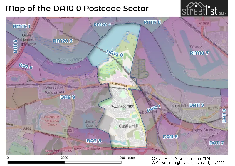
The DA10 0 Postcode shares a border with DA2 8 (BEAN, DARENTH, DARTFORD), DA10 1 (Ebbsfleet Valley), DA11 8 (Northfleet, GRAVESEND), DA13 9 (Istead Rise, Southfleet, Cobham), DA9 9 (GREENHITHE , STONE , HORNS CROSS ) and DA11 9 (Northfleet, GRAVESEND).
The sector is within the post town of SWANSCOMBE.
DA10 0 is a postcode sector within the DA10 postcode district which is within the DA Dartford postcode area.
The Royal Mail delivery office for the DA10 0 postal sector is the Swanscombe Delivery Office.
The area of the DA10 0 postcode sector is 1.68 square miles which is 4.36 square kilometres or 1,078.09 square acres.
The DA10 0 postcode sector is crossed by the A2 Major A road.

Map of the DA10 0 Postcode Sector
Explore the DA10 0 postcode sector by using our free interactive map.
| D | A | 1 | 0 | - | 0 | X | X |
| D | A | 1 | 0 | Space | 0 | Letter | Letter |
Official List of Streets
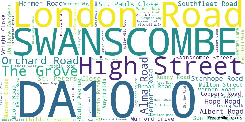
SWANSCOMBE (68 Streets)
Unofficial Streets or Alternative Spellings
Northfleet
GALLEY HILL ROAD LOWER ROADGREENHITHE
KNOCKHALL ROAD WAINWRIGHT AVENUEStone
LONDON ROADBean
WATLING STREETShorne
WATLING STREETEbbsfleet Valley
INTERNATIONAL WAYWeather Forecast for DA10 0
Press Button to Show Forecast for Gravesend-Broadness
| Time Period | Icon | Description | Temperature | Rain Probability | Wind |
|---|---|---|---|---|---|
| 03:00 to 06:00 | Partly cloudy (night) | 5.0°C (feels like 1.0°C) | 0.00% | NW 9 mph | |
| 06:00 to 09:00 | Cloudy | 5.0°C (feels like 2.0°C) | 3.00% | NNW 9 mph | |
| 09:00 to 12:00 | Cloudy | 8.0°C (feels like 5.0°C) | 5.00% | NNW 11 mph | |
| 12:00 to 15:00 | Cloudy | 10.0°C (feels like 7.0°C) | 4.00% | NNW 11 mph | |
| 15:00 to 18:00 | Overcast | 11.0°C (feels like 8.0°C) | 7.00% | NNW 11 mph | |
| 18:00 to 21:00 | Cloudy | 10.0°C (feels like 7.0°C) | 3.00% | N 9 mph | |
| 21:00 to 00:00 | Partly cloudy (night) | 7.0°C (feels like 5.0°C) | 1.00% | NE 4 mph |
Press Button to Show Forecast for Gravesend-Broadness
| Time Period | Icon | Description | Temperature | Rain Probability | Wind |
|---|---|---|---|---|---|
| 00:00 to 03:00 | Cloudy | 5.0°C (feels like 4.0°C) | 4.00% | SW 4 mph | |
| 03:00 to 06:00 | Cloudy | 5.0°C (feels like 3.0°C) | 4.00% | SW 7 mph | |
| 06:00 to 09:00 | Cloudy | 6.0°C (feels like 4.0°C) | 6.00% | WSW 7 mph | |
| 09:00 to 12:00 | Cloudy | 9.0°C (feels like 7.0°C) | 6.00% | W 9 mph | |
| 12:00 to 15:00 | Overcast | 11.0°C (feels like 9.0°C) | 15.00% | WNW 9 mph | |
| 15:00 to 18:00 | Cloudy | 12.0°C (feels like 10.0°C) | 12.00% | WNW 9 mph | |
| 18:00 to 21:00 | Cloudy | 10.0°C (feels like 9.0°C) | 14.00% | NW 7 mph | |
| 21:00 to 00:00 | Cloudy | 8.0°C (feels like 6.0°C) | 9.00% | NE 4 mph |
Press Button to Show Forecast for Gravesend-Broadness
| Time Period | Icon | Description | Temperature | Rain Probability | Wind |
|---|---|---|---|---|---|
| 00:00 to 03:00 | Cloudy | 6.0°C (feels like 5.0°C) | 6.00% | NNE 4 mph | |
| 03:00 to 06:00 | Cloudy | 5.0°C (feels like 4.0°C) | 5.00% | NE 4 mph | |
| 06:00 to 09:00 | Cloudy | 6.0°C (feels like 4.0°C) | 6.00% | NNE 4 mph | |
| 09:00 to 12:00 | Cloudy | 9.0°C (feels like 7.0°C) | 9.00% | NE 7 mph | |
| 12:00 to 15:00 | Cloudy | 10.0°C (feels like 9.0°C) | 12.00% | SE 9 mph | |
| 15:00 to 18:00 | Cloudy | 11.0°C (feels like 9.0°C) | 15.00% | SE 9 mph | |
| 18:00 to 21:00 | Cloudy | 10.0°C (feels like 8.0°C) | 16.00% | ESE 9 mph | |
| 21:00 to 00:00 | Cloudy | 8.0°C (feels like 6.0°C) | 16.00% | ESE 9 mph |
Press Button to Show Forecast for Gravesend-Broadness
| Time Period | Icon | Description | Temperature | Rain Probability | Wind |
|---|---|---|---|---|---|
| 00:00 to 03:00 | Cloudy | 8.0°C (feels like 6.0°C) | 18.00% | ESE 7 mph | |
| 03:00 to 06:00 | Cloudy | 8.0°C (feels like 6.0°C) | 18.00% | ESE 7 mph | |
| 06:00 to 09:00 | Cloudy | 9.0°C (feels like 7.0°C) | 18.00% | ESE 7 mph | |
| 09:00 to 12:00 | Cloudy | 11.0°C (feels like 9.0°C) | 17.00% | SE 9 mph | |
| 12:00 to 15:00 | Light rain shower (day) | 13.0°C (feels like 10.0°C) | 36.00% | ESE 9 mph | |
| 15:00 to 18:00 | Light rain | 13.0°C (feels like 11.0°C) | 50.00% | ESE 11 mph | |
| 18:00 to 21:00 | Cloudy | 13.0°C (feels like 11.0°C) | 14.00% | ESE 9 mph | |
| 21:00 to 00:00 | Cloudy | 11.0°C (feels like 9.0°C) | 14.00% | ESE 9 mph |
Schools and Places of Education Within the DA10 0 Postcode Sector
Ebbsfleet Academy
Academy sponsor led
Southfleet Road, Swanscombe, Kent, DA10 0BZ
Head: Mrs Gurjit Kaur Shergill
Ofsted Rating: Good
Inspection: 2019-10-02 (1666 days ago)
Website: Visit Ebbsfleet Academy Website
Phone: 01322242252
Number of Pupils: 766
Manor Community Primary School
Academy converter
Keary Road, Swanscombe, Kent, DA10 0BU
Head: Mrs Natalie Hill
Ofsted Rating: Good
Inspection: 2018-10-31 (2002 days ago)
Website: Visit Manor Community Primary School Website
Phone: 01322383314
Number of Pupils: 670
The Craylands School
Community school
Craylands Lane, Swanscombe, Kent, DA10 0LP
Head: Mr Kris Hiscock
Ofsted Rating: Good
Inspection: 2019-09-25 (1673 days ago)
Website: Visit The Craylands School Website
Phone: 01322388230
Number of Pupils: 417
House Prices in the DA10 0 Postcode Sector
| Type of Property | 2018 Average | 2018 Sales | 2017 Average | 2017 Sales | 2016 Average | 2016 Sales | 2015 Average | 2015 Sales |
|---|---|---|---|---|---|---|---|---|
| Detached | £359,000 | 1 | £386,500 | 2 | £342,000 | 4 | £382,333 | 3 |
| Semi-Detached | £284,333 | 15 | £277,125 | 12 | £283,000 | 12 | £230,473 | 11 |
| Terraced | £255,336 | 67 | £251,240 | 50 | £246,083 | 75 | £201,466 | 59 |
| Flats | £172,850 | 4 | £148,589 | 13 | £152,000 | 10 | £125,567 | 15 |
Important Postcodes DA10 0 in the Postcode Sector
DA10 0BU is the postcode for Manor Cp School, Keary Road, Swanscombe Childrens Centre, Manor Cp School, Keary Road, Manor Community Primary School, Keary Road, MAIN BUILDING, Manor Cp School, Keary Road, and EXTENSION (2015), Manor Cp School, Keary Road
DA10 0BZ is the postcode for The Ebbsfleet Academy, Southfleet Road
DA10 0GA is the postcode for Swanscombe & Greenhithe Town Council, Council Offices & Community Hall, The Grove
DA10 0LP is the postcode for The Swanscombe Centre, Crylands Lane, The Swanscombe Centre, Craylands Lane, Gravesham Community Leisure, The Swanscombe Centre, and The Craylands School, Craylands Lane
| The DA10 0 Sector is within these Local Authorities |
|
|---|---|
| The DA10 0 Sector is within these Counties |
|
| The DA10 0 Sector is within these Water Company Areas |
|