The DA13 postcode district is a postal district located in the DA Dartford postcode area with a population of 14,332 residents according to the 2021 England and Wales Census.
The area of the DA13 postcode district is 19.45 square miles which is 50.39 square kilometres or 12,450.76 acres.
Currently, the DA13 district has about 376 postcode units spread across 2 geographic postcode sectors.
Given that each sector allows for 400 unique postcode combinations, the district has a capacity of 800 postcodes. With 376 postcodes already in use, this leaves 424 units available.
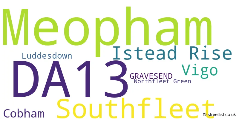
The largest settlement in the DA13 postal code is Meopham followed by Istead Rise, and Southfleet.
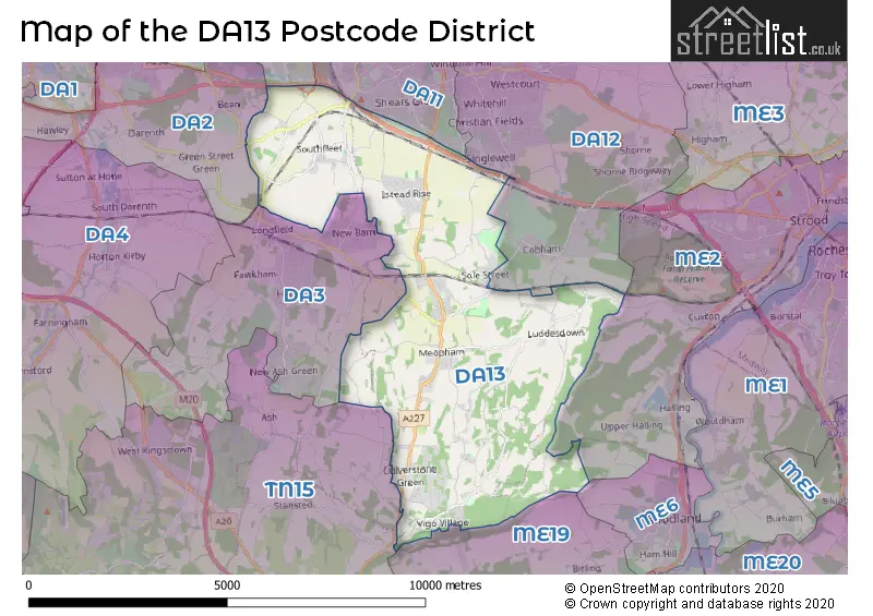
The DA13 Postcode shares a border with DA2 (DARTFORD, WILMINGTON, DARENTH), DA3 (LONGFIELD, New Ash Green, Hartley), DA11 (Northfleet, GRAVESEND), ME19 (Kings Hill, East Malling, WEST MALLING), ME2 (ROCHESTER, Halling, Strood) and DA12 (GRAVESEND, Shorne, Cobham).
The primary settlement in the DA13 postcode district is Meopham, located in the county of Kent, England. Other significant settlements in the district include Cobham, Luddesdown, and Vigo. The post town for the district is Gravesend.
For the district DA13, we have data on 2 postcode sectors. Here's a breakdown: The sector DA13 0, covers Meopham and Vigo in Kent. The sector DA13 9, covers Southfleet and Istead Rise and Cobham in Kent.

Map of the DA13 Postcode District
Explore the DA13 postcode district by using our free interactive map.
When it comes to local government, postal geography often disregards political borders. However, for a breakdown in the DA13 District: the district mostly encompasses the Gravesham District (B) (312 postcodes), and finally, the Dartford District (B) area (60 postcodes).
Weather Forecast for DA13
Press Button to Show Forecast for Hartley
| Time Period | Icon | Description | Temperature | Rain Probability | Wind |
|---|---|---|---|---|---|
| 12:00 to 15:00 | Overcast | 10.0°C (feels like 7.0°C) | 43.00% | W 11 mph | |
| 15:00 to 18:00 | Cloudy | 10.0°C (feels like 8.0°C) | 16.00% | W 11 mph | |
| 18:00 to 21:00 | Cloudy | 8.0°C (feels like 6.0°C) | 36.00% | NNE 7 mph | |
| 21:00 to 00:00 | Cloudy | 7.0°C (feels like 5.0°C) | 10.00% | ENE 4 mph |
Press Button to Show Forecast for Hartley
| Time Period | Icon | Description | Temperature | Rain Probability | Wind |
|---|---|---|---|---|---|
| 00:00 to 03:00 | Cloudy | 5.0°C (feels like 3.0°C) | 8.00% | NE 4 mph | |
| 03:00 to 06:00 | Cloudy | 4.0°C (feels like 2.0°C) | 5.00% | NE 7 mph | |
| 06:00 to 09:00 | Cloudy | 5.0°C (feels like 2.0°C) | 5.00% | NE 7 mph | |
| 09:00 to 12:00 | Cloudy | 7.0°C (feels like 5.0°C) | 5.00% | ENE 7 mph | |
| 12:00 to 15:00 | Cloudy | 9.0°C (feels like 7.0°C) | 7.00% | E 7 mph | |
| 15:00 to 18:00 | Cloudy | 9.0°C (feels like 7.0°C) | 11.00% | E 9 mph | |
| 18:00 to 21:00 | Cloudy | 8.0°C (feels like 6.0°C) | 11.00% | E 9 mph | |
| 21:00 to 00:00 | Cloudy | 7.0°C (feels like 4.0°C) | 13.00% | E 9 mph |
Press Button to Show Forecast for Hartley
| Time Period | Icon | Description | Temperature | Rain Probability | Wind |
|---|---|---|---|---|---|
| 00:00 to 03:00 | Light rain | 6.0°C (feels like 4.0°C) | 45.00% | E 9 mph | |
| 03:00 to 06:00 | Light rain | 6.0°C (feels like 3.0°C) | 48.00% | ENE 9 mph | |
| 06:00 to 09:00 | Overcast | 7.0°C (feels like 4.0°C) | 23.00% | ENE 9 mph | |
| 09:00 to 12:00 | Cloudy | 9.0°C (feels like 7.0°C) | 21.00% | E 9 mph | |
| 12:00 to 15:00 | Cloudy | 11.0°C (feels like 9.0°C) | 17.00% | E 11 mph | |
| 15:00 to 18:00 | Light rain shower (day) | 12.0°C (feels like 9.0°C) | 37.00% | E 11 mph | |
| 18:00 to 21:00 | Light rain | 11.0°C (feels like 8.0°C) | 52.00% | E 11 mph | |
| 21:00 to 00:00 | Light rain | 10.0°C (feels like 7.0°C) | 51.00% | E 11 mph |
Press Button to Show Forecast for Hartley
| Time Period | Icon | Description | Temperature | Rain Probability | Wind |
|---|---|---|---|---|---|
| 00:00 to 03:00 | Light rain | 9.0°C (feels like 7.0°C) | 54.00% | E 9 mph | |
| 03:00 to 06:00 | Light rain | 9.0°C (feels like 7.0°C) | 52.00% | E 9 mph | |
| 06:00 to 09:00 | Light rain | 9.0°C (feels like 7.0°C) | 48.00% | SE 11 mph | |
| 09:00 to 12:00 | Light rain shower (day) | 11.0°C (feels like 8.0°C) | 43.00% | SSE 13 mph | |
| 12:00 to 15:00 | Light rain shower (day) | 12.0°C (feels like 10.0°C) | 40.00% | S 13 mph | |
| 15:00 to 18:00 | Heavy rain shower (day) | 13.0°C (feels like 11.0°C) | 51.00% | S 13 mph | |
| 18:00 to 21:00 | Light rain shower (day) | 12.0°C (feels like 10.0°C) | 36.00% | SSW 11 mph | |
| 21:00 to 00:00 | Partly cloudy (night) | 10.0°C (feels like 8.0°C) | 6.00% | S 9 mph |
Where is the DA13 Postcode District?
The postcode district DA13 is located in the town of Gravesend. It is near several towns: Longfield to the west (2.003 miles away), Southfleet to the northwest (3.742 miles away), Snodland to the southeast (4.655 miles away), Rochester to the east (5.209 miles away), and Tilbury to the north (5.847 miles away). Additionally, the district is approximately 22.869 miles from the center of London.
The district is within the post town of GRAVESEND.
The sector has postcodes within the nation of England.
The DA13 Postcode District is covers the following regions.
- Kent Thames Gateway - Kent - South East (England)
- West Kent - Kent - South East (England)
| Postcode Sector | Delivery Office |
|---|---|
| DA13 0 | Gravesend Delivery Office |
| DA13 9 | Gravesend Delivery Office |
| D | A | 1 | 3 | - | X | X | X |
| D | A | 1 | 3 | Space | Numeric | Letter | Letter |
Current Monthly Rental Prices
| # Bedrooms | Min Price | Max Price | Avg Price |
|---|---|---|---|
| 3 | £1,500 | £1,900 | £1,663 |
| 4 | £2,500 | £3,000 | £2,750 |
Current House Prices
| # Bedrooms | Min Price | Max Price | Avg Price |
|---|---|---|---|
| £18,000 | £1,275,000 | £295,230 | |
| 1 | £297,500 | £450,000 | £369,167 |
| 2 | £198,500 | £560,000 | £386,417 |
| 3 | £214,500 | £710,000 | £508,924 |
| 4 | £328,500 | £1,500,000 | £755,081 |
| 5 | £528,000 | £1,200,000 | £831,400 |
| 6 | £800,000 | £800,000 | £800,000 |
| 7 | £1,500,000 | £1,500,000 | £1,500,000 |
Estate Agents who Operate in the DA13 District
| Logo | Name | Brand Name | Address | Contact Number | Total Properties |
|---|---|---|---|---|---|
 | Meopham | Wards | Wrotham Road, Meopham, DA13 0HN | 01474 551876 | 28 |
 | Worthing | Homewise | 1 Liverpool Gardens Worthing BN11 1TF | 01903 497338 | 12 |
 | Meopham | Kings Estate Agents | Station Approach, Meopham, DA13 0HP | 01474 551738 | 8 |
 | South East | eXp UK | 1 Northumberland Avenue, Trafalgar Square, London, WC2N 5BW | 03304 609968 | 6 |
 | Gravesend | Robinson Michael & Jackson | 21 A & B King Street Gravesend DA12 2EB | 01474 552175 | 5 |
| Type of Property | 2018 Average | 2018 Sales | 2017 Average | 2017 Sales | 2016 Average | 2016 Sales | 2015 Average | 2015 Sales |
|---|---|---|---|---|---|---|---|---|
| Detached | £535,174 | 72 | £594,844 | 79 | £566,457 | 106 | £501,750 | 103 |
| Semi-Detached | £391,946 | 68 | £377,994 | 59 | £404,923 | 59 | £343,534 | 74 |
| Terraced | £298,049 | 40 | £296,951 | 40 | £301,699 | 54 | £250,760 | 46 |
| Flats | £211,625 | 4 | £238,620 | 5 | £151,000 | 1 | £150,833 | 6 |