The DA15 9 postcode sector is within the county of Greater London.
Did you know? According to the 2021 Census, the DA15 9 postcode sector is home to a bustling 8,617 residents!
Given that each sector allows for 400 unique postcode combinations. Letters C, I, K, M, O and V are not allowed in the last two letters of a postcode. With 136 postcodes already in use, this leaves 264 units available.
The DA15 9 postal code covers the settlement of SIDCUP .
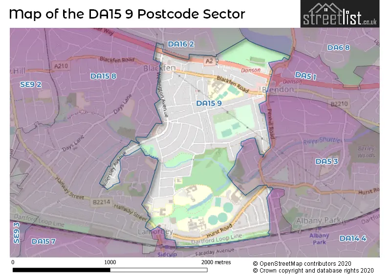
The DA15 9 Postcode shares a border with DA5 1 (BEXLEY ), DA15 8 (SIDCUP ), DA16 2 (WELLING ), DA5 3 (BEXLEY ), DA6 8 (BEXLEYHEATH ), DA14 4 (SIDCUP ) and DA15 7 (SIDCUP ).
The sector is within the post town of SIDCUP.
DA15 9 is a postcode sector within the DA15 postcode district which is within the DA Dartford postcode area.
The Royal Mail delivery office for the DA15 9 postal sector is the Sidcup Delivery Office.
The area of the DA15 9 postcode sector is 0.87 square miles which is 2.26 square kilometres or 559.38 square acres.
Waterways within the DA15 9 postcode sector include the River Shuttle.

Map of the DA15 9 Postcode Sector
Explore the DA15 9 postcode sector by using our free interactive map.
| D | A | 1 | 5 | - | 9 | X | X |
| D | A | 1 | 5 | Space | 9 | Letter | Letter |
Official List of Streets
SIDCUP (47 Streets)
Unofficial Streets or Alternative Spellings
SIDCUP
ANNANDALE ROAD ASHCROFT CRESCENT EAST ROCHESTER WAY FOOTS CRAY LANE HADDON GROVE HALFWAY STREET LYNDON AVENUE OAKLANDS AVENUE ROWANWOOD AVENUE STATION ROAD WHITE OAK GARDENS WILLOW AVENUEBEXLEY
OAKLEY PARK PENHILL ROADWELLING
RADNOR AVENUESIDCUP,
WESTWOOD LANEBEXLEY,
HURST ROADWeather Forecast for DA15 9
Press Button to Show Forecast for Bexley
| Time Period | Icon | Description | Temperature | Rain Probability | Wind |
|---|---|---|---|---|---|
| 09:00 to 12:00 | Cloudy | 10.0°C (feels like 8.0°C) | 6.00% | W 9 mph | |
| 12:00 to 15:00 | Cloudy | 11.0°C (feels like 8.0°C) | 40.00% | W 11 mph | |
| 15:00 to 18:00 | Cloudy | 11.0°C (feels like 9.0°C) | 40.00% | WNW 9 mph | |
| 18:00 to 21:00 | Cloudy | 9.0°C (feels like 8.0°C) | 11.00% | N 7 mph | |
| 21:00 to 00:00 | Cloudy | 8.0°C (feels like 6.0°C) | 8.00% | ENE 4 mph |
Press Button to Show Forecast for Bexley
| Time Period | Icon | Description | Temperature | Rain Probability | Wind |
|---|---|---|---|---|---|
| 00:00 to 03:00 | Cloudy | 6.0°C (feels like 5.0°C) | 6.00% | NE 4 mph | |
| 03:00 to 06:00 | Cloudy | 5.0°C (feels like 3.0°C) | 5.00% | NE 4 mph | |
| 06:00 to 09:00 | Cloudy | 5.0°C (feels like 3.0°C) | 5.00% | NE 4 mph | |
| 09:00 to 12:00 | Cloudy | 8.0°C (feels like 6.0°C) | 5.00% | ENE 7 mph | |
| 12:00 to 15:00 | Overcast | 9.0°C (feels like 8.0°C) | 11.00% | E 7 mph | |
| 15:00 to 18:00 | Overcast | 10.0°C (feels like 8.0°C) | 15.00% | E 7 mph | |
| 18:00 to 21:00 | Cloudy | 9.0°C (feels like 7.0°C) | 13.00% | E 9 mph | |
| 21:00 to 00:00 | Cloudy | 8.0°C (feels like 6.0°C) | 14.00% | E 7 mph |
Press Button to Show Forecast for Bexley
| Time Period | Icon | Description | Temperature | Rain Probability | Wind |
|---|---|---|---|---|---|
| 00:00 to 03:00 | Light rain | 7.0°C (feels like 5.0°C) | 46.00% | E 7 mph | |
| 03:00 to 06:00 | Light rain | 7.0°C (feels like 5.0°C) | 48.00% | ENE 7 mph | |
| 06:00 to 09:00 | Overcast | 7.0°C (feels like 5.0°C) | 20.00% | ENE 7 mph | |
| 09:00 to 12:00 | Cloudy | 9.0°C (feels like 7.0°C) | 20.00% | E 9 mph | |
| 12:00 to 15:00 | Cloudy | 12.0°C (feels like 10.0°C) | 17.00% | E 9 mph | |
| 15:00 to 18:00 | Light rain shower (day) | 12.0°C (feels like 11.0°C) | 40.00% | E 9 mph | |
| 18:00 to 21:00 | Light rain | 12.0°C (feels like 10.0°C) | 51.00% | E 9 mph | |
| 21:00 to 00:00 | Light rain | 11.0°C (feels like 9.0°C) | 49.00% | E 9 mph |
Press Button to Show Forecast for Bexley
| Time Period | Icon | Description | Temperature | Rain Probability | Wind |
|---|---|---|---|---|---|
| 00:00 to 03:00 | Light rain | 10.0°C (feels like 8.0°C) | 53.00% | E 7 mph | |
| 03:00 to 06:00 | Light rain | 10.0°C (feels like 8.0°C) | 53.00% | E 7 mph | |
| 06:00 to 09:00 | Light rain | 10.0°C (feels like 8.0°C) | 53.00% | SE 9 mph | |
| 09:00 to 12:00 | Light rain shower (day) | 11.0°C (feels like 9.0°C) | 41.00% | SSE 11 mph | |
| 12:00 to 15:00 | Heavy rain shower (day) | 13.0°C (feels like 11.0°C) | 59.00% | S 11 mph | |
| 15:00 to 18:00 | Heavy rain shower (day) | 14.0°C (feels like 12.0°C) | 53.00% | S 11 mph | |
| 18:00 to 21:00 | Partly cloudy (day) | 13.0°C (feels like 11.0°C) | 14.00% | SSW 9 mph | |
| 21:00 to 00:00 | Clear night | 11.0°C (feels like 10.0°C) | 9.00% | SSW 7 mph |
Schools and Places of Education Within the DA15 9 Postcode Sector
Blackfen School for Girls
Academy converter
Blackfen Road, Sidcup, Kent, DA15 9NU
Head: Mr Matthew Brown
Ofsted Rating: Good
Inspection: 2019-12-18 (1590 days ago)
Website: Visit Blackfen School for Girls Website
Phone: 02083031887
Number of Pupils: 1464
Burnt Oak Junior School
Academy sponsor led
Burnt Oak Lane, Sidcup, Kent, DA15 9DA
Head: Mr Ian McManus
Ofsted Rating: Outstanding
Inspection: 2018-07-11 (2115 days ago)
Website: Visit Burnt Oak Junior School Website
Phone: 02083005854
Number of Pupils: 245
Chatsworth Infant School
Academy converter
Burnt Oak Lane, Sidcup, Kent, DA15 9DD
Head: Mr Ian McManus
Ofsted Rating: Good
Inspection: 2019-09-19 (1680 days ago)
Website: Visit Chatsworth Infant School Website
Phone: 02083009295
Number of Pupils: 207
Chislehurst and Sidcup Grammar School
Academy converter
Hurst Road, Sidcup, Kent, DA15 9AG
Head: Mr Nigel Walker
Ofsted Rating: Good
Inspection: 2022-12-14 (498 days ago)
Website: Visit Chislehurst and Sidcup Grammar School Website
Phone: 02083026511
Number of Pupils: 1445
Holy Trinity Lamorbey Church of England School
Academy converter
Burnt Oak Lane, Sidcup, Kent, DA15 9DB
Head: Mr Oliver Winstone
Ofsted Rating: Good
Inspection: 2023-10-04 (204 days ago)
Website: Visit Holy Trinity Lamorbey Church of England School Website
Phone: 02083003613
Number of Pupils: 305
Hurstmere School
Academy converter
Hurst Road, Sidcup, Kent, DA15 9AW
Head: Mrs Lynn Bennett
Ofsted Rating: Requires improvement
Inspection: 2022-09-28 (575 days ago)
Website: Visit Hurstmere School Website
Phone: 02083005665
Number of Pupils: 1030
Marlborough School
Community special school
Marlborough Park Avenue, Sidcup, Kent, DA15 9DP
Head: Dr Elizabeth Smith
Ofsted Rating: Good
Inspection: 2020-01-16 (1561 days ago)
Website: Visit Marlborough School Website
Phone: 02083006896
Number of Pupils: 81
Sherwood Park Primary School
Academy converter
Sherwood Park Avenue, Sidcup, Kent, DA15 9JQ
Head: Miss Natasha Trayers
Ofsted Rating: Good
Inspection: 2023-06-22 (308 days ago)
Website: Visit Sherwood Park Primary School Website
Phone: 02083036300
Number of Pupils: 309
House Prices in the DA15 9 Postcode Sector
| Type of Property | 2018 Average | 2018 Sales | 2017 Average | 2017 Sales | 2016 Average | 2016 Sales | 2015 Average | 2015 Sales |
|---|---|---|---|---|---|---|---|---|
| Detached | £560,000 | 2 | £470,666 | 3 | £423,333 | 3 | £568,750 | 2 |
| Semi-Detached | £485,510 | 49 | £499,536 | 49 | £461,512 | 42 | £421,390 | 32 |
| Terraced | £344,463 | 67 | £357,520 | 65 | £334,839 | 70 | £303,037 | 73 |
| Flats | £238,250 | 10 | £254,389 | 9 | £200,306 | 18 | £172,421 | 19 |
Important Postcodes DA15 9 in the Postcode Sector
DA15 9AE is the postcode for Sidcup Leisure Centre, Hurst Road
DA15 9AG is the postcode for QUINTON BLAKE BLOCK, Chislehurst & Sidcup Grammar School, Hurst Road, MAIN BLOCK, Chislehurst & Sidcup Grammar School, Hurst Road, Chislehurst & Sidcup Grammar School, Hurst Road, NEW BLOCK, Chislehurst & Sidcup Grammar School, Hurst Road, LEGACY, Chislehurst & Sidcup Grammar School, Hurst Road, HUMANITIES, Chislehurst & Sidcup Grammar School, Hurst Road, JUBILEE PAVILION, Chislehurst & Sidcup Grammar School, Hurst Road, and DRAMA AND MUSIC BLOCK, Chislehurst & Sidcup Grammar School, Hurst Road
DA15 9AW is the postcode for Hurstmere Foundation School, Hurst Road, MATHS / HUMANITIES BLOCK, Hurstmere Foundation School, Hurst Road, Hurstmere School, MATHS / HUMANITIES BLOCK, Hurst Road, and Hurstmere School, Hurst Road
DA15 9BZ is the postcode for Sidcup Youth Centre, Burnt Oak Lane
DA15 9DA is the postcode for BURNT OAK JUNIOR SCHOOL, Burnt Oak Primary School, Burnt Oak Lane, and Burnt Oak Primary School, Burnt Oak Lane
DA15 9DB is the postcode for Holy Trinity Lamorbey CE Primary School, Burnt Oak Lane, and Holy Trinity Lamorbey CE Primary School, Burnt Oak Lane, Sidcup
DA15 9DD is the postcode for Chatsworth Infant School, Burnt Oak Lane
DA15 9DF is the postcode for Rose Bruford College of Speech & Drama, Burnt Oak Lane, Lamorbey Park, Rose Theatre & Courtyard, Rose Bruford College, Lamborey Park, Barn Theatre & Stables, Rose Bruford College, Lamorbey Park, Lamorbey House, Rose Bruford College, Lamorbey Park, and Masefield, Rose Bruford College, Lamorbey Park
DA15 9DL is the postcode for Marlborough School, Marlborough Park Avenue
DA15 9JN is the postcode for Sherwood Park School, Sherwood Park Avenue
DA15 9JQ is the postcode for Sherwood Park School, Sherwood Park Avenue
DA15 9NU is the postcode for TECHNOLOGY, Blackfen School for Girls, Blackfen Road, 14-19, Blackfen School for Girls, Blackfen Road, PPE & ITC (DANCE STUDIO), Blackfen School for Girls, Blackfen Road, BUSINESS STUDIES, Blackfen School for Girls, Blackfen Road, MAIN BUILDING, Blackfen School for Girls, Blackfen Road, SCIENCE & SPORTS HALL, Blackfen School for Girls, Blackfen Road, and Blackfen School for Girls, Blackfen Road
| The DA15 9 Sector is within these Local Authorities |
|
|---|---|
| The DA15 9 Sector is within these Counties |
|
| The DA15 9 Sector is within these Water Company Areas |
|