The DA2 8 postcode sector is within the county of Kent.
Did you know? According to the 2021 Census, the DA2 8 postcode sector is home to a bustling 2,038 residents!
Given that each sector allows for 400 unique postcode combinations. Letters C, I, K, M, O and V are not allowed in the last two letters of a postcode. With 57 postcodes already in use, this leaves 343 units available.
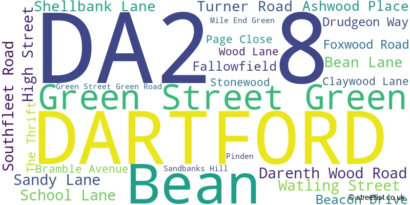
The largest settlement in the DA2 8 postal code is BEAN followed by DARENTH, and DARTFORD.
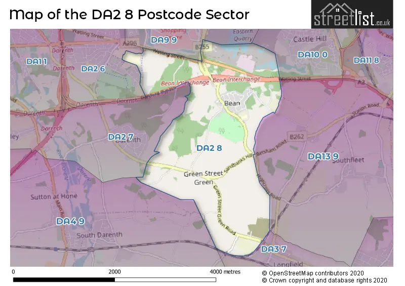
The DA2 8 Postcode shares a border with DA2 6 (DARTFORD, STONE, DARENTH), DA2 7 (WILMINGTON, DARENTH, HAWLEY), DA3 7 (LONGFIELD, Hartley, Longfield Hill), DA4 9 (South Darenth, Sutton At Hone, Horton Kirby), DA13 9 (Istead Rise, Southfleet, Cobham), DA9 9 (GREENHITHE , STONE , HORNS CROSS ) and DA10 0 (SWANSCOMBE).
The sector is within the post town of DARTFORD.
DA2 8 is a postcode sector within the DA2 postcode district which is within the DA Dartford postcode area.
The Royal Mail delivery office for the DA2 8 postal sector is the Dartford Delivery Office.
The area of the DA2 8 postcode sector is 3.01 square miles which is 7.79 square kilometres or 1,925.08 square acres.
The DA2 8 postcode sector is crossed by the A2 Major A road.

Map of the DA2 8 Postcode Sector
Explore the DA2 8 postcode sector by using our free interactive map.
| D | A | 2 | - | 8 | X | X |
| D | A | 2 | Space | 8 | Letter | Letter |
Official List of Streets
Bean (19 Streets)
DARTFORD (5 Streets)
Green Street Green (2 Streets)
Unofficial Streets or Alternative Spellings
Shorne
WATLING STREETDARTFORD
DARENTH PARK AVENUE POWELL AVENUELongfield Hill
MAIN ROADSouth Darenth
CANADA FARM ROAD DARTFORD BYPASS DENE YARD GILLS ROAD GREEN STREET ROMAN ROAD ST MARGARETS ROADWeather Forecast for DA2 8
Press Button to Show Forecast for Hartley
| Time Period | Icon | Description | Temperature | Rain Probability | Wind |
|---|---|---|---|---|---|
| 18:00 to 21:00 | Cloudy | 8.0°C (feels like 6.0°C) | 4.00% | N 9 mph | |
| 21:00 to 00:00 | Cloudy | 5.0°C (feels like 4.0°C) | 3.00% | ENE 4 mph |
Press Button to Show Forecast for Hartley
| Time Period | Icon | Description | Temperature | Rain Probability | Wind |
|---|---|---|---|---|---|
| 00:00 to 03:00 | Cloudy | 5.0°C (feels like 3.0°C) | 4.00% | S 4 mph | |
| 03:00 to 06:00 | Cloudy | 5.0°C (feels like 3.0°C) | 5.00% | SSW 9 mph | |
| 06:00 to 09:00 | Cloudy | 6.0°C (feels like 3.0°C) | 39.00% | SW 9 mph | |
| 09:00 to 12:00 | Cloudy | 9.0°C (feels like 6.0°C) | 8.00% | W 9 mph | |
| 12:00 to 15:00 | Overcast | 10.0°C (feels like 7.0°C) | 43.00% | W 11 mph | |
| 15:00 to 18:00 | Cloudy | 10.0°C (feels like 8.0°C) | 16.00% | W 11 mph | |
| 18:00 to 21:00 | Cloudy | 8.0°C (feels like 6.0°C) | 36.00% | NNE 7 mph | |
| 21:00 to 00:00 | Cloudy | 7.0°C (feels like 5.0°C) | 10.00% | ENE 4 mph |
Press Button to Show Forecast for Hartley
| Time Period | Icon | Description | Temperature | Rain Probability | Wind |
|---|---|---|---|---|---|
| 00:00 to 03:00 | Cloudy | 5.0°C (feels like 3.0°C) | 8.00% | NE 4 mph | |
| 03:00 to 06:00 | Cloudy | 4.0°C (feels like 2.0°C) | 5.00% | NE 7 mph | |
| 06:00 to 09:00 | Cloudy | 5.0°C (feels like 2.0°C) | 5.00% | NE 7 mph | |
| 09:00 to 12:00 | Cloudy | 7.0°C (feels like 5.0°C) | 5.00% | ENE 7 mph | |
| 12:00 to 15:00 | Cloudy | 9.0°C (feels like 7.0°C) | 7.00% | E 7 mph | |
| 15:00 to 18:00 | Cloudy | 9.0°C (feels like 7.0°C) | 11.00% | E 9 mph | |
| 18:00 to 21:00 | Cloudy | 8.0°C (feels like 6.0°C) | 11.00% | E 9 mph | |
| 21:00 to 00:00 | Cloudy | 7.0°C (feels like 4.0°C) | 13.00% | E 9 mph |
Press Button to Show Forecast for Hartley
| Time Period | Icon | Description | Temperature | Rain Probability | Wind |
|---|---|---|---|---|---|
| 00:00 to 03:00 | Light rain | 6.0°C (feels like 4.0°C) | 45.00% | E 9 mph | |
| 03:00 to 06:00 | Light rain | 6.0°C (feels like 3.0°C) | 48.00% | ENE 9 mph | |
| 06:00 to 09:00 | Overcast | 7.0°C (feels like 4.0°C) | 23.00% | ENE 9 mph | |
| 09:00 to 12:00 | Cloudy | 9.0°C (feels like 7.0°C) | 21.00% | E 9 mph | |
| 12:00 to 15:00 | Cloudy | 11.0°C (feels like 9.0°C) | 17.00% | E 11 mph | |
| 15:00 to 18:00 | Light rain shower (day) | 12.0°C (feels like 9.0°C) | 37.00% | E 11 mph | |
| 18:00 to 21:00 | Light rain | 11.0°C (feels like 8.0°C) | 52.00% | E 11 mph | |
| 21:00 to 00:00 | Light rain | 10.0°C (feels like 7.0°C) | 51.00% | E 11 mph |
Press Button to Show Forecast for Hartley
| Time Period | Icon | Description | Temperature | Rain Probability | Wind |
|---|---|---|---|---|---|
| 00:00 to 03:00 | Light rain | 9.0°C (feels like 7.0°C) | 54.00% | E 9 mph | |
| 03:00 to 06:00 | Light rain | 9.0°C (feels like 7.0°C) | 52.00% | E 9 mph | |
| 06:00 to 09:00 | Light rain | 9.0°C (feels like 7.0°C) | 48.00% | SE 11 mph | |
| 09:00 to 12:00 | Light rain shower (day) | 11.0°C (feels like 8.0°C) | 43.00% | SSE 13 mph | |
| 12:00 to 15:00 | Light rain shower (day) | 12.0°C (feels like 10.0°C) | 40.00% | S 13 mph | |
| 15:00 to 18:00 | Heavy rain shower (day) | 13.0°C (feels like 11.0°C) | 51.00% | S 13 mph | |
| 18:00 to 21:00 | Light rain shower (day) | 12.0°C (feels like 10.0°C) | 36.00% | SSW 11 mph | |
| 21:00 to 00:00 | Partly cloudy (night) | 10.0°C (feels like 8.0°C) | 6.00% | S 9 mph |
Schools and Places of Education Within the DA2 8 Postcode Sector
Bean Primary School
Community school
School Lane, Dartford, Kent, DA2 8AW
Head: Mr Graham Reilly
Ofsted Rating: Good
Inspection: 2019-11-06 (1631 days ago)
Website: Visit Bean Primary School Website
Phone: 01474833225
Number of Pupils: 190
Greenlands Primary School
Academy converter
Green Street Green Road, Dartford, Kent, DA2 8DH
Head: Mrs Alison Cook
Ofsted Rating: Requires improvement
Inspection: 2023-05-18 (342 days ago)
Website: Visit Greenlands Primary School Website
Phone: 01474703178
Number of Pupils: 187
House Prices in the DA2 8 Postcode Sector
| Type of Property | 2018 Average | 2018 Sales | 2017 Average | 2017 Sales | 2016 Average | 2016 Sales | 2015 Average | 2015 Sales |
|---|---|---|---|---|---|---|---|---|
| Detached | £485,625 | 4 | £419,600 | 5 | £513,400 | 5 | £397,417 | 3 |
| Semi-Detached | £315,063 | 8 | £297,500 | 2 | £331,073 | 8 | £310,000 | 2 |
| Terraced | £286,318 | 11 | £324,000 | 12 | £275,625 | 8 | £231,894 | 9 |
| Flats | £189,700 | 1 | £0 | 0 | £0 | 0 | £190,000 | 1 |
Important Postcodes DA2 8 in the Postcode Sector
DA2 8AL is the postcode for Bean Primary School, School Lane, and Bean Primary School, School Lane, Bean
DA2 8DA is the postcode for ACCOMMODATION BLOCK 1, Dartford & Gravesham N H S Trust, Darent Valley Hospital, Darenth Wood Road, DARENT VALLEY HOSPITAL, DARENTH WOOD ROAD, ACCOMMODATION BLOCK 4, Dartford & Gravesham N H S Trust, Darent Valley Hospital, Darenth Wood Road, ACCOMMODATION BLOCK 2, Dartford & Gravesham N H S Trust, Darent Valley Hospital, Darenth Wood Road, The Jasmine Centre, Darent Valley Hospital, Dartford & Gravesham N H S Trust, Darent Valley Hospital, Darenth Wood Road, Jasmine Centre & Kings Renal Unit, Darent Valley Hospital, Darenth Wood Road, and ACCOMMODATION BLOCK 3, Dartford & Gravesham N H S Trust, Darent Valley Hospital, Darenth Wood Road
DA2 8DH is the postcode for Darenth Cp School, Green Street Green Road
| The DA2 8 Sector is within these Local Authorities |
|
|---|---|
| The DA2 8 Sector is within these Counties |
|
| The DA2 8 Sector is within these Water Company Areas |
|