Postcode district

DA6 Postcode District

DA6 is one of 2 Postcode Districts for the Bexleyheath Post town in Greater London

The DA6 postcode district is located in the DA Dartford postal area, DA6 has a population of 11,057 residents according to the 2021 England and Wales Census..

The area of the district is 1.07 square miles (2.78 square kilometres or 686.53 acres).

A wide range of spatial data has been analysed to present this overview of DA6. If you would like anything added, please contact us.

Sectors 2
Streets indexed 126
Geographical postcodes 268
Councils crossed 1

Map of DA6

Explore the postcode district using the interactive map.

Larger circles indicate higher recorded crime totals.

On this page

District overview

The primary settlement in the DA6 postcode district is Bexleyheath, located in Greater London. The most significant post town in this area is also Bexleyheath.

There are 2 postcode sectors within the district. Here's a breakdown:
The sector DA6 7, covers Bexleyheath in Greater London.
The sector DA6 8, covers Bexleyheath in Greater London.

The post town for this district is BEXLEYHEATH.

When it comes to local government, postal geography often disregards political borders. However, this district intersects the following councils: the district mostly encompasses the Bexley London Boro area with a total of 255 postal codes.

Nearest towns

To help place the district geographically, here are nearby towns and their approximate direction from the district centre.

Town Distance (miles) Direction
Swanley 4.18 SSE
Dartford 4.70 E
Swanscombe 6.32 E
Grays 8.31 ENE
Northfleet 9.05 E
Tilbury 9.76 E
Gravesend 10.03 E
City of London 10.78 WNW
Chigwell 11.76 NNW
City of Westminster 11.86 WNW
Sevenoaks 12.90 S
Warlingham 13.03 SW
Westerham 13.24 SSW
Brentwood 13.64 NNE
Stanford-le-Hope 14.30 ENE
Loughton 14.30 NNW
Oxted 14.87 SSW
Caterham 15.15 SW
Snodland 15.71 ESE
Basildon 15.78 ENE

Postcode information

Total geographical postcodes: 268

Location Post Town Sector Number of postcodes
BEXLEYHEATH BEXLEYHEATH DA6 8 126
BEXLEYHEATH BEXLEYHEATH DA6 7 123
BEXLEYHEATH BEXLEYHEATH DA6 7 14
BEXLEYHEATH BEXLEYHEATH DA6 8 5

Street list for DA6

ABBEY ROAD

Bexleyheath, Greater London

Local Road
USRN: 20100005

ADAMS SQUARE

Bexleyheath, Greater London

Local Road
USRN: 20100010

ALBION ROAD A207

A-road

Bexleyheath, Greater London

A Road
USRN: 20100018

ALERS ROAD

Bexleyheath, Greater London

Local Road
USRN: 20100023

ARNSBERG WAY A221

A-road

Bexleyheath, Greater London

A Road
USRN: 20100050

ASKERN CLOSE

Bexleyheath, Greater London

Local Road
USRN: 20100062

AVENUE ROAD

Minor road

Bexleyheath, Greater London

Minor Road
USRN: 20100067

BALCOMBE CLOSE

Bexleyheath, Greater London

Local Road
USRN: 20101699

BANKS LANE

Bexleyheath, Greater London

Local Road
USRN: 20100079

BARTON CLOSE

Bexleyheath, Greater London

Local Road
USRN: 20100089

BEAN ROAD

Bexleyheath, Greater London

Local Road
USRN: 20100099

BELLEVUE ROAD

Bexleyheath, Greater London

Local Road
USRN: 20100116

BRASTED CLOSE

Bexleyheath, Greater London

Local Road
USRN: 20100190

BROADWAY A221

A-road

Bexleyheath, Greater London

A Road
USRN: 20100205

BROADWAY A221

A-road

Bexleyheath, Greater London

A Road
USRN: 20100205

BROOK LANE

Bexley, Greater London

Local Road
USRN: 20100207

BROOM MEAD

Bexleyheath, Greater London

Local Road
USRN: 20100213

BROOMFIELD ROAD

Bexleyheath, Greater London

Local Road
USRN: 20100214

BROOMHILL RISE

Bexleyheath, Greater London

Local Road
USRN: 20100215

BRUNSWICK CLOSE

Bexleyheath, Greater London

Local Road
USRN: 20100219

BRUNSWICK ROAD

Bexleyheath, Greater London

Local Road
USRN: 20100220

CAREY COURT

Bexleyheath, Greater London

Local Road
USRN: 20100260

CHARLOTTE CLOSE

Bexleyheath, Greater London

Local Road
USRN: 20101673

CHURCH ROAD

Bexleyheath, Greater London

Local Road
USRN: 20100315

CLARENCE ROAD

Bexleyheath, Greater London

Local Road
USRN: 20100324

COBHAM PLACE

Bexleyheath, Greater London

Local Road
USRN: 20100341

CROOK LOG A207

A-road

Bexleyheath, Greater London

A Road
USRN: 20100397

CUXTON CLOSE

Bexleyheath, Greater London

Local Road
USRN: 20101714

DALLIN ROAD

Bexleyheath, Greater London

Local Road
USRN: 20100417

DANSON ROAD A221

A-road

Bexley, Greater London

A Road
USRN: 20101842

DANSON ROAD A221

A-road

Bexleyheath, Greater London

A Road
USRN: 20100426

DASHWOOD CLOSE

Bexleyheath, Greater London

Local Road
USRN: 20100431

DEVONSHIRE ROAD

Bexleyheath, Greater London

Local Road
USRN: 20100446

DITTON ROAD

Bexleyheath, Greater London

Local Road
USRN: 20100447

EAST ROCHESTER WAY A2

A-road

Bexley, Greater London

A Road
USRN: 20100475

EMERTON CLOSE

Bexleyheath, Greater London

Local Road
USRN: 20100506

ERITH ROAD A220

A-road

Bexleyheath, Greater London

A Road
USRN: 20100511

FAIRWAY

Bexleyheath, Greater London

Local Road
USRN: 20100534

FAYGATE CRESCENT

Bexleyheath, Greater London

Local Road
USRN: 20100543

FRETA ROAD

Bexleyheath, Greater London

Local Road
USRN: 20100575

FRETA ROAD

Bexleyheath, Greater London

Local Road
USRN: 20100575

FRISWELL PLACE

Bexleyheath, Greater London

Local Road
USRN: 20100581

GAINSBOROUGH SQUARE

Bexleyheath, Greater London

Local Road
USRN: 20100586

GEDDES PLACE

Bexleyheath, Greater London

Local Road
USRN: 20100593

GRAHAM ROAD

Bexleyheath, Greater London

Local Road
USRN: 20100617

GRAVEL HILL A220

A-road

Bexleyheath, Greater London

A Road
USRN: 20100628

GRAVEL HILL CLOSE

Bexleyheath, Greater London

Local Road
USRN: 20100629

GRAZELEY CLOSE

Bexleyheath, Greater London

Local Road
USRN: 20100630

GREEN VALE

Bexleyheath, Greater London

Local Road
USRN: 20100632

GROSVENOR ROAD

Bexleyheath, Greater London

Local Road
USRN: 20100642

HALCOT AVENUE

Bexleyheath, Greater London

Local Road
USRN: 20100654

HANOVER WAY

Bexleyheath, Greater London

Local Road
USRN: 20100665

HANSOL ROAD

Bexleyheath, Greater London

Local Road
USRN: 20100666

HARCOURT ROAD

Bexleyheath, Greater London

Local Road
USRN: 20100670

HAWTHORN ROAD

Bexleyheath, Greater London

Local Road
USRN: 20100690

HEATHFIELD ROAD

Bexleyheath, Greater London

Local Road
USRN: 20100701

HEATHFIELD ROAD

Bexleyheath, Greater London

Local Road
USRN: 20100701

HIGHFIELD ROAD

Bexleyheath, Greater London

Local Road
USRN: 20100718

HIGHLAND ROAD

Bexleyheath, Greater London

Local Road
USRN: 20100719

HORLEY CLOSE

Bexleyheath, Greater London

Local Road
USRN: 20100746

HORSHAM ROAD

Bexleyheath, Greater London

Local Road
USRN: 20100749

IRIS AVENUE

Bexley, Greater London

Local Road
USRN: 20100767

IVERHURST CLOSE

Bexleyheath, Greater London

Local Road
USRN: 20100772

IZANE ROAD

Bexleyheath, Greater London

Local Road
USRN: 20100773

IZANE ROAD

Bexleyheath, Greater London

Local Road
USRN: 20100773

KINGSLEY COURT

Bexleyheath, Greater London


USRN: 20101735

LATHAM ROAD

Bexleyheath, Greater London

Local Road
USRN: 20100827

LAUNTON DRIVE

Bexleyheath, Greater London

Restricted Local Access Road
USRN: 20101797

LENOR CLOSE

Bexleyheath, Greater London

Local Road
USRN: 20100839

LEWIN ROAD

Bexleyheath, Greater London

Local Road
USRN: 20100847

LION ROAD

Bexleyheath, Greater London

Local Road
USRN: 20100863

LONDON ROAD A207

A-road

Crayford, Greater London

A Road
USRN: 20100870

LORDSWOOD CLOSE

Bexleyheath, Greater London


USRN: 20101836

LYNSTED CLOSE

Bexleyheath, Greater London

Local Road
USRN: 20100900

MARKET PLACE

Bexleyheath, Greater London

Local Road
USRN: 20100931

MARTIN DENE

Bexleyheath, Greater London

Local Road
USRN: 20100939

MARTIN DENE

Bexleyheath, Greater London

Local Road
USRN: 20100939

MARTIN RISE

Bexleyheath, Greater London

Local Road
USRN: 20100940

MEADOW CLOSE

Bexleyheath, Greater London

Local Road
USRN: 20101697

METHUEN ROAD

Bexleyheath, Greater London

Local Road
USRN: 20100972

MIDHURST HILL

Bexleyheath, Greater London

Local Road
USRN: 20100977

MOUNT DRIVE

Bexleyheath, Greater London

Local Road
USRN: 20101003

MOUNT ROAD

Bexleyheath, Greater London

Local Road
USRN: 20101005

NORTH CLOSE

Bexleyheath, Greater London

Local Road
USRN: 20101031

NORWICH PLACE

Bexleyheath, Greater London


USRN: 20101044

OAKHOUSE ROAD

Bexleyheath, Greater London

Local Road
USRN: 20101053

OAKLANDS CLOSE

Bexleyheath, Greater London

Local Road
USRN: 20101057

OAKLANDS ROAD

Bexleyheath, Greater London

Local Road
USRN: 20101058

OLRON CRESCENT

Bexleyheath, Greater London

Local Road
USRN: 20101072

PADDOCK ROAD

Bexleyheath, Greater London

Local Road
USRN: 20101092

PETWORTH ROAD

Bexleyheath, Greater London

Local Road
USRN: 20101138

PINCOTT ROAD

Bexleyheath, Greater London

Local Road
USRN: 20101149

PINNACLE HILL

Bexleyheath, Greater London

Local Road
USRN: 20101147

QUEEN ANNE GATE

Bexleyheath, Greater London

Local Road
USRN: 20101175

RED HOUSE LANE

Bexleyheath, Greater London

Local Road
USRN: 20101197

REGAL WALK

Bexleyheath, Greater London


USRN: 20103279

REGENCY WAY

Bexleyheath, Greater London

Local Road
USRN: 20101201

ROBIN HOOD LANE

Bexleyheath, Greater London

Local Road
USRN: 20101219

ROBINA CLOSE

Bexleyheath, Greater London

Local Road
USRN: 20101220

ROCHESTER DRIVE

Bexley, Greater London

Local Road
USRN: 20101222

ROSSLAND CLOSE

Bexleyheath, Greater London

Local Road
USRN: 20101231

ROYAL OAK ROAD

Bexleyheath, Greater London

Local Road
USRN: 20101234

SANDFORD ROAD

Bexleyheath, Greater London

Local Road
USRN: 20101257

SHERBROOKE CLOSE

Bexleyheath, Greater London

Local Road
USRN: 20101284

SIBLEY CLOSE

Bexleyheath, Greater London

Local Road
USRN: 20101299

SOUTH CLOSE

Bexleyheath, Greater London

Local Road
USRN: 20101315

STANDARD ROAD

Bexleyheath, Greater London

Local Road
USRN: 20101329

STERLING ROAD

Bexleyheath, Greater London

Local Road
USRN: 20101897

SUNLAND AVENUE

Bexleyheath, Greater London

Local Road
USRN: 20101398

SYDNEY ROAD

Bexleyheath, Greater London

Local Road
USRN: 20101413

TALEHANGERS CLOSE

Bexleyheath, Greater London

Local Road
USRN: 20101875

THE GROVE

Bexleyheath, Greater London

Local Road
USRN: 20101447

THE MALL

Bexleyheath, Greater London


USRN: 20101650

TIMOTHY CLOSE

Bexleyheath, Greater London

Local Road
USRN: 20101675

TODD CLOSE

Bexleyheath, Greater London


USRN: 20105254

TOWNLEY ROAD

Minor road

Bexleyheath, Greater London

Minor Road
USRN: 20101479

TRINITY PLACE

Bexleyheath, Greater London

Local Road
USRN: 20101482

TUDOR WALK

Bexley, Greater London


USRN: 20101484

UPTON ROAD

Minor road

Bexleyheath, Greater London

Minor Road
USRN: 20101502

VICTORIA ROAD

Bexleyheath, Greater London

Local Road
USRN: 20101518

WARREN CLOSE

Bexleyheath, Greater London

Local Road
USRN: 20101539

WARREN ROAD

Bexleyheath, Greater London

Local Road
USRN: 20101540

WATERVIEW CLOSE

Bexleyheath, Greater London

Restricted Local Access Road
USRN: 20101860

WATLING STREET

A-road

Bexleyheath, Greater London

A Road
USRN: 20101549

WEST STREET

Bexleyheath, Greater London

Local Road
USRN: 20101568

WINDSOR ROAD

Bexleyheath, Greater London

Local Road
USRN: 20101602

Crime overview

Top streets by recorded crime

Most common crime types

Crime type Count
Violence and sexual offences 1279
Shoplifting 641
Other theft 338
Public order 317
Criminal damage and arson 252
Drugs 244
Vehicle crime 232
Theft from the person 203
Burglary 139
Robbery 121
Other crime 57
Possession of weapons 23
Bicycle theft 19
Anti-social behaviour 16

Retail and shopping

Street Town Locality Number of shops Central postcode Map
BROADWAY BEXLEYHEATH 233 DA6 7DW View map
MARKET PLACE BEXLEYHEATH 6 DA6 7DU View map

Schools in the district

Townley Grammar School

Phase: Secondary

Address: Townley Road , Bexleyheath
Postcode: DA6 7AB

Headteacher: Mrs Nevita Pandya (Headteacher)

Ofsted rating: Outstanding

Bexleyheath Academy

Phase: Secondary

Address: Woolwich Road , Bexleyheath
Postcode: DA6 7DA

Headteacher: Ms Rubeka Luthfa (Principal)

Ofsted rating: Good

St Columba's Catholic Boys' School

Phase: Secondary

Address: Halcot Avenue , Bexleyheath
Postcode: DA6 7QB

Headteacher: Mr Dave Evans (Headteacher)

Ofsted rating: Good

Gravel Hill Primary School

Phase: Primary

Address: Watling Street , Bexleyheath
Postcode: DA6 7QJ

Headteacher: Miss Melanie Neale (Headteacher)

Ofsted rating: Good

St Catherine's Catholic School

Phase: Secondary

Address: Watling Street , Bexleyheath
Postcode: DA6 7QJ

Headteacher: Mrs Nicola Thompson (Headteacher)

Ofsted rating: Good

Gravel Hill Primary School

Phase: Primary

Address: Watling Street , Bexleyheath
Postcode: DA6 7QJ

Headteacher: Miss Melanie Neale (Headteacher)

Ofsted rating: Good

Crook Log Primary School

Phase: Primary

Address: Crook Log , Bexleyheath
Postcode: DA6 8EQ

Headteacher: Mrs Patricia Barratt (Headteacher)

Ofsted rating: Good

Healthcare services

# Name Address Type Contact
1 Bexleyheath Dental Practice 306 BROADWAY, BEXLEYHEATH, KENT, DA6 8AA GENERAL DENTAL PRACTICE No contact details listed
2 Dental Surgery 42 CROOK LOG, BEXLEYHEATH, KENT, DA6 8BS GENERAL DENTAL PRACTICE No contact details listed
3 Dentix Bexleyheath 4-5 MARKET PLACE, BEXLEYHEATH, DA6 7DU GENERAL DENTAL PRACTICE No contact details listed
4 Bexleyheath Dental Practice 4 CROOK LOG, BEXLEYHEATH, DA6 8BW GENERAL DENTAL PRACTICE No contact details listed

Data accessed from NHS Digital and updated monthly.

# Name Address Type Contact
1 The Albion Surgery 6 PINCOTT ROAD, BEXLEYHEATH, KENT, DA6 7LP GP PRACTICE
Call 020 83048334
2 Sidcup Medical Centre (crook Log Surgery) 19 CROOK LOG, BEXLEYHEATH, DA6 8DZ BRANCH SURGERY No contact details listed

Data accessed from NHS Digital and updated monthly.

# Name Address Type Contact
1 Boots 31-33 THE MALL, BROADWAY SHOPPING CENTRE, BEXLEYHEATH, KENT, DA6 7JJ PHARMACY
Call 02083 011657
2 Crook Log Pharmacy 329 BROADWAY, BEXLEYHEATH, KENT, DA6 8DT PHARMACY
Call 02083 011991
3 Broadway Pharmacy 172 BROADWAY, BEXLEYHEATH, DA6 7BN PHARMACY
Call 02083 032707

Data accessed from NHS Digital and updated monthly.

# Name Address Type Contact
1 Specsavers (bexleyheath) 116A BROADWAY, BEXLEYHEATH, KENT, DA6 7DQ OPTICAL SITE No contact details listed
2 Vision Express (bexleyheath) 5 THE MALL, BROADWAY SHOPPING CENTRE, BEXLEYHEATH, KENT, DA6 7JJ OPTICAL SITE No contact details listed
3 Bexley Eyes Ltd 25 THE MALL, BROADWAY SHOPPING CENTRE, BEXLEYHEATH, KENT, DA6 7JJ OPTICAL SITE No contact details listed
4 Optical Express [bexleyheath] 37 THE MALL, BROADWAY SHOPPING CENTRE, BEXLEYHEATH, KENT, DA6 7JJ OPTICAL SITE No contact details listed
5 Linklater Optometrists 120 BROADWAY, BEXLEYHEATH, KENT, DA6 7DQ OPTICAL SITE No contact details listed
6 Primary Ophthalmic Solutions (bexley) CIVIC OFFICES, 2 WATLING STREET, BEXLEYHEATH, DA6 7AT OPTICAL SITE No contact details listed

Data accessed from NHS Digital and updated monthly.

Property and housing

Yearly house price averages for the district

Type of property 2025 average 2025 sales 2024 average 2024 sales 2023 average 2023 sales 2022 average 2022 sales
Detached £1,325,919 16 £643,444 9 £742,100 15 £791,341 22
Semi-detached £549,563 48 £511,163 47 £563,496 48 £549,182 55
Terraced £409,096 34 £480,774 33 £480,207 29 £498,196 35
Flats £277,710 66 £311,795 81 £310,844 145 £315,652 123

Transport and connectivity

Stations in the district

No stations found in this postcode district.

Accessible motorway junctions

M25 J2

Average Driving Time from within the district: 6.42

Average Driving Distance: 5.24

Number of Postcodes that can access the Motorway Junction: 248

M25 J3

Average Driving Time from within the district: 9.61

Average Driving Distance: 8.42

Number of Postcodes that can access the Motorway Junction: 248

M25 J30

Average Driving Time from within the district: 13.30

Average Driving Distance: 10.61

Number of Postcodes that can access the Motorway Junction: 248


Royal Mail delivery and sorting offices

Delivery offices serving this district
Postal sector Delivery office
DA6 7 Bexleyheath Delivery Office
DA6 8 Bexleyheath Delivery Office

Postcode format

How this district code is structured
D A 6 - X X X
D A 6 Space Numeric Letter Letter

Tourist attractions

We found 1 visitor attractions in or around this district.

Name Category Detail Map
Red House (The National Trust) Historic Properties Historic House / House and Garden / Palace View map

Administrative and boundary notes

The DA6 postal code covers the settlement of BEXLEYHEATH.

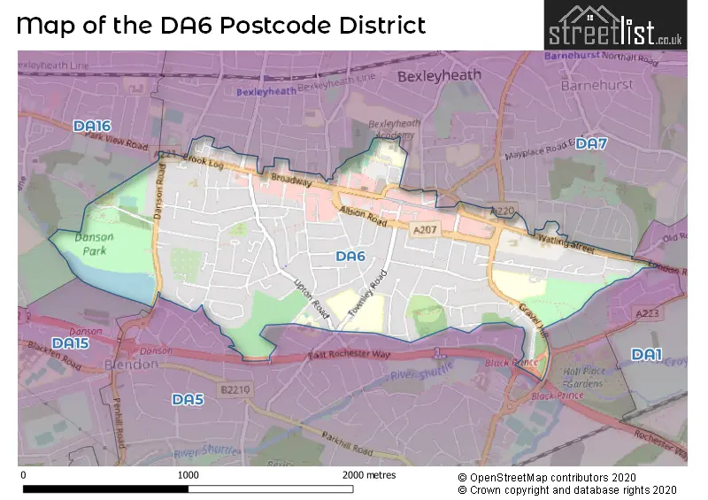
The DA6 Postcode shares a border with DA5 (BEXLEY), DA7 (BEXLEYHEATH) and DA16 (WELLING).

Maps and visuals

Map of the DA6 postcode
District map
A word cloud for the DA6 postcode
Word cloud showing place names in the district
Map of the DA6 district
Additional district map

Weather

Weather Forecast for Bexley

Powered by Met Office DataPoint under the Open Government Licence.

© streetlist.co.uk 2026
Contains public sector information licensed under the Open Government Licence v2.0.
© Crown copyright and database rights 2026
© OpenStreetMap contributors 2026