The DE1 postcode district is a postal district located in the DE Derby postcode area with a population of 16,419 residents according to the 2021 England and Wales Census.
The area of the DE1 postcode district is 1.55 square miles which is 4.02 square kilometres or 992.98 acres.
Currently, the DE1 district has about 688 postcode units spread across 19 geographic postcode sectors.
Given that each sector allows for 400 unique postcode combinations, the district has a capacity of 7,600 postcodes. With 688 postcodes already in use, this leaves 6912 units available.
The DE1 postal code covers the settlement of DERBY.
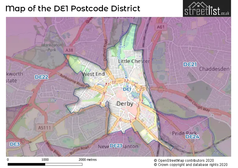
The DE1 Postcode shares a border with DE23 (DERBY, Littleover, Sunnyhill) and DE22 (DERBY, Allestree, Darley Abbey).
The primary settlement in the DE1 postcode district is Derby, located in the county of Derbyshire. Derby is the largest settlement in the district with a count of 190. There are other significant settlements in the district, including Derby, with counts of 174, and Derby with counts of 229. The most significant post town in the district is Derby.
For the district DE1, we have data on 5 postcode sectors. Here's a breakdown: The sector DE1 0 is non-geographic. It's often designated for PO Boxes, large organisations, or special services. The sector DE1 1, covers Derby in Derbyshire. The sector DE1 2, covers Derby in Derbyshire. The sector DE1 3, covers Derby in Derbyshire. The sector DE1 9 is non-geographic. It's often designated for PO Boxes, large organisations, or special services.


Map of the DE1 Postcode District
Explore the DE1 postcode district by using our free interactive map.
When it comes to local government, postal geography often disregards political borders. However, for a breakdown in the DE1 District: the district mostly encompasses the City of Derby (B) area with a total of 692 postcodes.
Weather Forecast for DE1
Press Button to Show Forecast for Derby
| Time Period | Icon | Description | Temperature | Rain Probability | Wind |
|---|---|---|---|---|---|
| 09:00 to 12:00 | Cloudy | 8.0°C (feels like 5.0°C) | 11.00% | WNW 9 mph | |
| 12:00 to 15:00 | Cloudy | 8.0°C (feels like 6.0°C) | 46.00% | N 9 mph | |
| 15:00 to 18:00 | Cloudy | 9.0°C (feels like 8.0°C) | 9.00% | NNE 7 mph | |
| 18:00 to 21:00 | Cloudy | 9.0°C (feels like 8.0°C) | 9.00% | N 4 mph | |
| 21:00 to 00:00 | Cloudy | 7.0°C (feels like 5.0°C) | 7.00% | E 7 mph |
Press Button to Show Forecast for Derby
| Time Period | Icon | Description | Temperature | Rain Probability | Wind |
|---|---|---|---|---|---|
| 00:00 to 03:00 | Cloudy | 5.0°C (feels like 3.0°C) | 4.00% | ENE 4 mph | |
| 03:00 to 06:00 | Cloudy | 4.0°C (feels like 2.0°C) | 4.00% | NE 4 mph | |
| 06:00 to 09:00 | Cloudy | 4.0°C (feels like 2.0°C) | 4.00% | NE 4 mph | |
| 09:00 to 12:00 | Partly cloudy (day) | 7.0°C (feels like 5.0°C) | 2.00% | ENE 7 mph | |
| 12:00 to 15:00 | Overcast | 9.0°C (feels like 8.0°C) | 9.00% | ENE 4 mph | |
| 15:00 to 18:00 | Cloudy | 10.0°C (feels like 9.0°C) | 8.00% | ENE 4 mph | |
| 18:00 to 21:00 | Cloudy | 9.0°C (feels like 7.0°C) | 9.00% | ENE 7 mph | |
| 21:00 to 00:00 | Partly cloudy (night) | 6.0°C (feels like 4.0°C) | 7.00% | ENE 7 mph |
Press Button to Show Forecast for Derby
| Time Period | Icon | Description | Temperature | Rain Probability | Wind |
|---|---|---|---|---|---|
| 00:00 to 03:00 | Partly cloudy (night) | 5.0°C (feels like 3.0°C) | 7.00% | ENE 7 mph | |
| 03:00 to 06:00 | Cloudy | 4.0°C (feels like 2.0°C) | 13.00% | ENE 7 mph | |
| 06:00 to 09:00 | Cloudy | 5.0°C (feels like 2.0°C) | 11.00% | NE 7 mph | |
| 09:00 to 12:00 | Overcast | 8.0°C (feels like 5.0°C) | 15.00% | ENE 9 mph | |
| 12:00 to 15:00 | Overcast | 10.0°C (feels like 7.0°C) | 23.00% | ENE 9 mph | |
| 15:00 to 18:00 | Overcast | 10.0°C (feels like 8.0°C) | 22.00% | ENE 11 mph | |
| 18:00 to 21:00 | Cloudy | 10.0°C (feels like 7.0°C) | 18.00% | ENE 11 mph | |
| 21:00 to 00:00 | Cloudy | 8.0°C (feels like 5.0°C) | 17.00% | NE 11 mph |
Press Button to Show Forecast for Derby
| Time Period | Icon | Description | Temperature | Rain Probability | Wind |
|---|---|---|---|---|---|
| 00:00 to 03:00 | Light rain | 7.0°C (feels like 4.0°C) | 50.00% | NE 11 mph | |
| 03:00 to 06:00 | Overcast | 7.0°C (feels like 4.0°C) | 25.00% | NE 11 mph | |
| 06:00 to 09:00 | Heavy rain | 7.0°C (feels like 5.0°C) | 74.00% | NE 9 mph | |
| 09:00 to 12:00 | Heavy rain | 9.0°C (feels like 7.0°C) | 78.00% | NE 9 mph | |
| 12:00 to 15:00 | Heavy rain shower (day) | 11.0°C (feels like 9.0°C) | 60.00% | NE 9 mph | |
| 15:00 to 18:00 | Heavy rain shower (day) | 11.0°C (feels like 9.0°C) | 59.00% | NE 9 mph | |
| 18:00 to 21:00 | Light rain shower (day) | 11.0°C (feels like 9.0°C) | 39.00% | ENE 9 mph | |
| 21:00 to 00:00 | Cloudy | 9.0°C (feels like 7.0°C) | 11.00% | S 7 mph |
Where is the DE1 Postcode District?
The postcode district for DE1 is located in Derby, which is a district town. It is surrounded by nearby towns such as Belper, Ilkeston, Burton-on-Trent, Ashby-de-la-Zouch, and Ashbourne. The distance from DE1 to London is approximately 113.5 miles.
The district covers the post towns of DERBY, ILKESTON.
The sector has postcodes within the nation of England.
The DE1 Postcode District is covers the following regions.
- Derby - Derbyshire and Nottinghamshire - East Midlands (England)
- South and West Derbyshire - Derbyshire and Nottinghamshire - East Midlands (England)
Postcode Sectors within the DE1 District
| Postcode Sector | Delivery Office |
|---|---|
| DE1 1 | Derby Town Delivery Office |
| DE1 2 | Derby Town Delivery Office |
| DE1 3 | Derby Town Delivery Office |
| DE1 9 | Derby Town Delivery Office |
| D | E | 1 | - | X | X | X |
| D | E | 1 | Space | Numeric | Letter | Letter |
Tourist Attractions within the Postcode Area
We found 1 visitor attractions within the DE1 postcode area
| Pickford's House Museum |
|---|
| Historic Properties |
| Historic House / House and Garden / Palace |
| View Pickford's House Museum on Google Maps |
Current Monthly Rental Prices
| # Bedrooms | Min Price | Max Price | Avg Price |
|---|---|---|---|
| £412 | £1,517 | £763 | |
| 1 | £303 | £1,083 | £610 |
| 2 | £399 | £1,600 | £911 |
| 3 | £360 | £2,000 | £814 |
| 4 | £364 | £2,750 | £915 |
| 5 | £360 | £2,500 | £994 |
| 6 | £377 | £3,510 | £1,124 |
| 7 | £542 | £3,033 | £1,257 |
| 8 | £455 | £5,200 | £1,117 |
| 9 | £477 | £477 | £477 |
Current House Prices
| # Bedrooms | Min Price | Max Price | Avg Price |
|---|---|---|---|
| £20,000 | £3,000,000 | £813,750 | |
| 1 | £72,500 | £200,000 | £127,832 |
| 2 | £47,500 | £250,000 | £145,287 |
| 3 | £145,000 | £475,000 | £221,423 |
| 4 | £210,000 | £280,000 | £246,428 |
| 5 | £190,000 | £295,000 | £248,333 |
| 6 | £240,000 | £475,000 | £346,667 |
| 7 | £430,000 | £430,000 | £430,000 |
| 12 | £20,000 | £20,000 | £20,000 |
Estate Agents who Operate in the DE1 District
| Logo | Name | Brand Name | Address | Contact Number | Total Properties |
|---|---|---|---|---|---|
 | Derby | Nicholas Humphreys | 15 Friar Gate Derby DE1 1BU | 01332 215535 | 36 |
 | Derby | R & R Student Lets | 34 Watson Street, Derby, DE1 3PJ | 01332 215625 | 33 |
 | Derby | Monkey vs Owl | Friar Gate Studios, Office 25 Ford Street Derby DE1 1EE | 01332 215611 | 29 |
 | Derby | Ashley Adams | 37-38 Iron Gate, Derby, DE1 3GA | 01332 215448 | 28 |
 | London | We Are Kin | Unit 9, Dalton House, 60 Windsor Avenue, London, SW19 2RR | 020 4538 1342 | 25 |
| Type of Property | 2018 Average | 2018 Sales | 2017 Average | 2017 Sales | 2016 Average | 2016 Sales | 2015 Average | 2015 Sales |
|---|---|---|---|---|---|---|---|---|
| Detached | £348,439 | 9 | £285,400 | 9 | £243,360 | 5 | £313,590 | 5 |
| Semi-Detached | £185,609 | 23 | £175,868 | 19 | £140,875 | 16 | £138,322 | 27 |
| Terraced | £158,963 | 120 | £157,850 | 119 | £149,936 | 123 | £156,801 | 125 |
| Flats | £103,981 | 124 | £111,858 | 255 | £125,284 | 169 | £124,988 | 127 |