The DE21 6 postcode sector is within the county of Derbyshire.
Did you know? According to the 2021 Census, the DE21 6 postcode sector is home to a bustling 17,520 residents!
Given that each sector allows for 400 unique postcode combinations. Letters C, I, K, M, O and V are not allowed in the last two letters of a postcode. With 343 postcodes already in use, this leaves 57 units available.
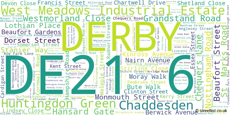
The largest settlement in the DE21 6 postal code is Chaddesden followed by DERBY, and West Meadows Industrial Estate.
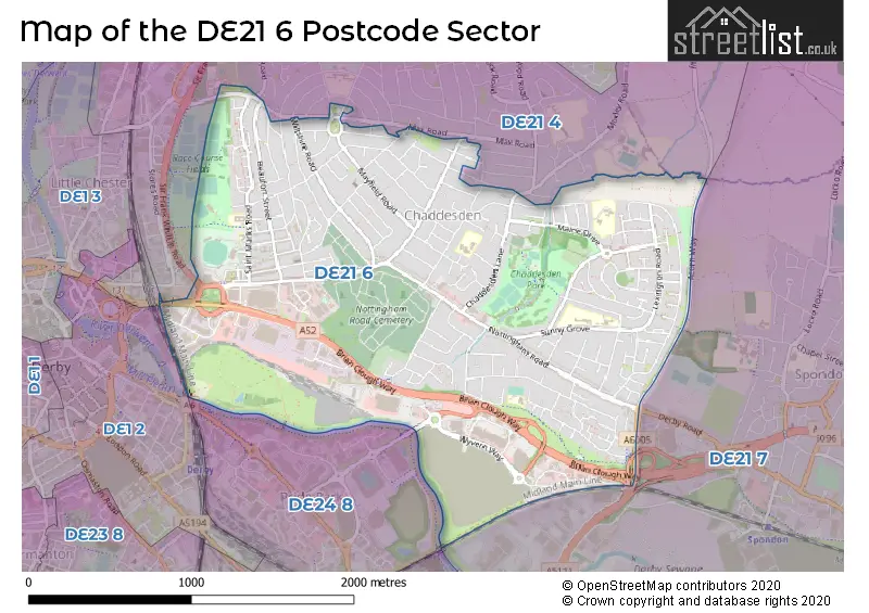
The DE21 6 Postcode shares a border with DE1 3 (DERBY), DE21 4 (Chaddesden, DERBY, Oakwood), DE21 7 (Spondon, DERBY), DE24 8 (DERBY, Alvaston, Allenton) and DE1 2 (DERBY).
The sector is within the post town of DERBY.
DE21 6 is a postcode sector within the DE21 postcode district which is within the DE Derby postcode area.
The Royal Mail delivery office for the DE21 6 postal sector is the Derby Town Delivery Office.
The area of the DE21 6 postcode sector is 2.23 square miles which is 5.78 square kilometres or 1,427.13 square acres.
The DE21 6 postcode sector is crossed by the A52 Major A road.
Waterways within the DE21 6 postcode sector include the River Derwent.

Map of the DE21 6 Postcode Sector
Explore the DE21 6 postcode sector by using our free interactive map.
| D | E | 2 | 1 | - | 6 | X | X |
| D | E | 2 | 1 | Space | 6 | Letter | Letter |
Official List of Streets
Chaddesden (135 Streets)
DERBY (60 Streets)
West Meadows Industrial Estate (7 Streets)
Unofficial Streets or Alternative Spellings
Chaddesden
HEREFORD ROAD HOLMEGATE CLOSE MAX ROAD ST. ANDREWS VIEW WILSTHORPE ROAD ACORN WAY BRIAN CLOUGH WAY EASTGATE PULLMAN ROAD SAINT JOHNS AVENUE SAINT JOHNS DRIVE SAINT MARKS ROAD THE PENTAGON THE SIDINGS THE UNDERPASS WYVERNSIDEDERBY
MEADOW ROAD OLD MANSFIELD ROAD SIR FRANK WHITTLE ROADSpondon
ASPEN DRIVE RAYNESWAYPride Park
DERWENT PARADEWeather Forecast for DE21 6
Press Button to Show Forecast for County Ground Derbyshire C.C.C.
| Time Period | Icon | Description | Temperature | Rain Probability | Wind |
|---|---|---|---|---|---|
| 00:00 to 03:00 | Partly cloudy (night) | 5.0°C (feels like 2.0°C) | 1.00% | N 7 mph | |
| 03:00 to 06:00 | Partly cloudy (night) | 4.0°C (feels like 2.0°C) | 1.00% | NNW 4 mph | |
| 06:00 to 09:00 | Partly cloudy (day) | 4.0°C (feels like 2.0°C) | 1.00% | NNW 4 mph | |
| 09:00 to 12:00 | Overcast | 8.0°C (feels like 5.0°C) | 7.00% | N 9 mph | |
| 12:00 to 15:00 | Overcast | 10.0°C (feels like 8.0°C) | 7.00% | N 9 mph | |
| 15:00 to 18:00 | Cloudy | 11.0°C (feels like 9.0°C) | 8.00% | N 7 mph | |
| 18:00 to 21:00 | Cloudy | 10.0°C (feels like 9.0°C) | 4.00% | NNE 7 mph | |
| 21:00 to 00:00 | Cloudy | 8.0°C (feels like 6.0°C) | 4.00% | NE 4 mph |
Press Button to Show Forecast for County Ground Derbyshire C.C.C.
| Time Period | Icon | Description | Temperature | Rain Probability | Wind |
|---|---|---|---|---|---|
| 00:00 to 03:00 | Cloudy | 6.0°C (feels like 5.0°C) | 5.00% | NE 4 mph | |
| 03:00 to 06:00 | Overcast | 6.0°C (feels like 4.0°C) | 8.00% | N 4 mph | |
| 06:00 to 09:00 | Overcast | 6.0°C (feels like 4.0°C) | 9.00% | NNE 4 mph | |
| 09:00 to 12:00 | Overcast | 7.0°C (feels like 5.0°C) | 12.00% | NE 7 mph | |
| 12:00 to 15:00 | Overcast | 9.0°C (feels like 7.0°C) | 14.00% | NE 9 mph | |
| 15:00 to 18:00 | Overcast | 10.0°C (feels like 8.0°C) | 12.00% | NE 9 mph | |
| 18:00 to 21:00 | Cloudy | 9.0°C (feels like 7.0°C) | 8.00% | NE 7 mph | |
| 21:00 to 00:00 | Cloudy | 7.0°C (feels like 5.0°C) | 9.00% | NE 7 mph |
Press Button to Show Forecast for County Ground Derbyshire C.C.C.
| Time Period | Icon | Description | Temperature | Rain Probability | Wind |
|---|---|---|---|---|---|
| 00:00 to 03:00 | Partly cloudy (night) | 5.0°C (feels like 3.0°C) | 6.00% | NE 4 mph | |
| 03:00 to 06:00 | Cloudy | 4.0°C (feels like 3.0°C) | 10.00% | NNE 4 mph | |
| 06:00 to 09:00 | Cloudy | 5.0°C (feels like 3.0°C) | 15.00% | NNE 4 mph | |
| 09:00 to 12:00 | Overcast | 7.0°C (feels like 6.0°C) | 21.00% | NNE 4 mph | |
| 12:00 to 15:00 | Light rain | 8.0°C (feels like 6.0°C) | 48.00% | ESE 4 mph | |
| 15:00 to 18:00 | Overcast | 9.0°C (feels like 8.0°C) | 19.00% | N 7 mph | |
| 18:00 to 21:00 | Overcast | 9.0°C (feels like 7.0°C) | 15.00% | N 7 mph | |
| 21:00 to 00:00 | Cloudy | 8.0°C (feels like 6.0°C) | 11.00% | N 4 mph |
Press Button to Show Forecast for County Ground Derbyshire C.C.C.
| Time Period | Icon | Description | Temperature | Rain Probability | Wind |
|---|---|---|---|---|---|
| 00:00 to 03:00 | Cloudy | 7.0°C (feels like 5.0°C) | 6.00% | N 4 mph | |
| 03:00 to 06:00 | Cloudy | 6.0°C (feels like 5.0°C) | 7.00% | N 7 mph | |
| 06:00 to 09:00 | Cloudy | 6.0°C (feels like 5.0°C) | 6.00% | N 7 mph | |
| 09:00 to 12:00 | Overcast | 9.0°C (feels like 7.0°C) | 10.00% | NNE 9 mph | |
| 12:00 to 15:00 | Overcast | 10.0°C (feels like 8.0°C) | 10.00% | N 9 mph | |
| 15:00 to 18:00 | Overcast | 11.0°C (feels like 9.0°C) | 17.00% | NNE 9 mph | |
| 18:00 to 21:00 | Cloudy | 10.0°C (feels like 8.0°C) | 11.00% | NNE 9 mph | |
| 21:00 to 00:00 | Partly cloudy (night) | 7.0°C (feels like 5.0°C) | 4.00% | NNE 7 mph |
Schools and Places of Education Within the DE21 6 Postcode Sector
Beaufort Community Primary School
Academy converter
Hampshire Road, Derby, Derbyshire, DE21 6BT
Head: Mrs Kate Beecroft
Ofsted Rating: Requires improvement
Inspection: 2023-11-08 (164 days ago)
Website: Visit Beaufort Community Primary School Website
Phone: 01332347275
Number of Pupils: 312
Chaddesden Park Primary School
Academy converter
Carson Road, Derby, Derbyshire, DE21 6JW
Head: Mrs Helen Smith
Ofsted Rating: Good
Inspection: 2022-09-14 (584 days ago)
Website: Visit Chaddesden Park Primary School Website
Phone: 01332662115
Number of Pupils: 298
Cherry Tree Hill Primary School
Academy converter
Lime Grove, Derby, Derbyshire, DE21 6WL
Head: Mr Paul Appleton
Ofsted Rating: Good
Inspection: 2023-07-13 (282 days ago)
Website: Visit Cherry Tree Hill Primary School Website
Phone: 01332673520
Number of Pupils: 619
Derwent Primary School
Academy sponsor led
St Mark's Road, Derby, Derbyshire, DE21 6AL
Head: Mrs Elizabeth Burke
Ofsted Rating: Good
Inspection: 2021-09-15 (948 days ago)
Website: Visit Derwent Primary School Website
Phone: 01332346222
Number of Pupils: 284
Meadow Farm Community Primary School
Community school
Foyle Avenue, Derby, Derbyshire, DE21 6TZ
Head: Mrs Samantha Eyre
Ofsted Rating: Good
Inspection: 2023-10-19 (184 days ago)
Website: Visit Meadow Farm Community Primary School Website
Phone: 01332662631
Number of Pupils: 164
St Alban's Catholic Voluntary Academy
Academy converter
Newstead Avenue, Derby, Derbyshire, DE21 6NU
Head: Mr Timothy Brogan
Ofsted Rating: Good
Inspection: 2023-03-29 (388 days ago)
Website: Visit St Alban's Catholic Voluntary Academy Website
Phone: 01332673823
Number of Pupils: 348
House Prices in the DE21 6 Postcode Sector
| Type of Property | 2018 Average | 2018 Sales | 2017 Average | 2017 Sales | 2016 Average | 2016 Sales | 2015 Average | 2015 Sales |
|---|---|---|---|---|---|---|---|---|
| Detached | £177,932 | 39 | £176,428 | 45 | £158,997 | 39 | £156,168 | 60 |
| Semi-Detached | £138,584 | 100 | £131,207 | 101 | £124,184 | 103 | £115,714 | 111 |
| Terraced | £107,247 | 59 | £100,611 | 48 | £105,133 | 56 | £97,155 | 58 |
| Flats | £67,667 | 3 | £62,944 | 9 | £65,143 | 7 | £64,533 | 6 |
Important Postcodes DE21 6 in the Postcode Sector
DE21 6AL is the postcode for The Light House, St. Marks Road, The Light House, St Marks Road, DERWENT COMMUNITY PRIMARY SCHOOL, ST MARKS ROAD, and Derwent Community Primary School, St. Marks Road
DE21 6BD is the postcode for Derwent Youth Centre, Monmouth Street
DE21 6BF is the postcode for Holborne House, Stanier Way, Wyvern Business Park, Chaddesden
DE21 6BT is the postcode for St. Giles Special School, Hampshire Road, Beaufort Community Primary School, Hampshire Road, and St Giles School, Hampshire Road
DE21 6DA is the postcode for ST GILES THE HIVE, NOTTINGHAM ROAD, DERBY
DE21 6ET is the postcode for Roe Farm Police Station, 1-3 Roe Farm Lane
DE21 6FP is the postcode for Derbyshire Fire & Rescue, Nottingham Road Fire Station
DE21 6JW is the postcode for Chaddesden Park Primary School, Carson Road, Chaddesden
DE21 6LA is the postcode for THE PARK MEDICAL CENTRE, MAINE DRIVE, DERBY
DE21 6LF is the postcode for Chaddesden Park Primary School, Tennessee Road, and Chaddesden Park Primary School, Carson Road
DE21 6LN is the postcode for Chaddesden Park Centre, Chaddesden Lane
DE21 6NU is the postcode for Junior Building, St. Albans Catholic Primary School, Newstead Avenue, JUNIOR SCHOOL, St. Albans RC Primary School, Newstead Avenue, and INFANT SCHOOL, St. Albans RC Primary School, Newstead Avenue
DE21 6TZ is the postcode for Meadow Farm Community Primary School, Foyle Avenue, Raynesway View Residential Home, Foyle Avenue, and Meadow Farm Community Primary School, Foyle Avenue, Chaddesden
DE21 6WJ is the postcode for Cherry Tree Junior School, Sunny Grove, Cherry Tree Junior School, Sunny Grove, Chaddesden, and Cherry Tree Hill Primary School, Sunny Grove
DE21 6WL is the postcode for Cherry Tree Infant & Nursery School, Lime Grove, Cherry Tree Hill Primary School, Lime Grove, and Cherry Tree Infant & Nursery School, Lime Grove, Chaddesden
DE21 6XX is the postcode for Derbyshire City Council, Perth Street
DE21 6YZ is the postcode for UNITS 2,4,5,12 MASONS PLACE CAMPUS, Derby College, Unit 5, Masons Place Business Park
| The DE21 6 Sector is within these Local Authorities |
|
|---|---|
| The DE21 6 Sector is within these Counties |
|
| The DE21 6 Sector is within these Water Company Areas |
|