The DE5 8 postcode sector is within the county of Derbyshire.
Did you know? According to the 2021 Census, the DE5 8 postcode sector is home to a bustling 4,249 residents!
Given that each sector allows for 400 unique postcode combinations. Letters C, I, K, M, O and V are not allowed in the last two letters of a postcode. With 85 postcodes already in use, this leaves 315 units available.
The largest settlement in the DE5 8 postal code is Marehay followed by Denby, and Denby Village.
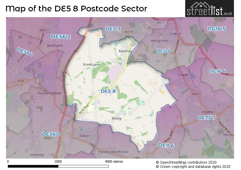
The DE5 8 Postcode shares a border with DE5 3 (RIPLEY, Pentrich, Butterley), DE7 6 (West Hallam, Smalley, Morley), DE56 0 (BELPER, Kilburn, Milford), DE75 7 (HEANOR, Loscoe, Shipley), DE5 9 (Codnor, Waingroves) and DE56 2 (BELPER, Ambergate, Heage).
The sector is within the post town of RIPLEY.
DE5 8 is a postcode sector within the DE5 postcode district which is within the DE Derby postcode area.
The Royal Mail delivery office for the DE5 8 postal sector is the Ripley (de) Delivery Office.
The area of the DE5 8 postcode sector is 4.93 square miles which is 12.77 square kilometres or 3,155.33 square acres.
The DE5 8 postcode sector is crossed by the A38 Major A road.

Map of the DE5 8 Postcode Sector
Explore the DE5 8 postcode sector by using our free interactive map.
| D | E | 5 | - | 8 | X | X |
| D | E | 5 | Space | 8 | Letter | Letter |
Official List of Streets
Marehay (20 Streets)
Denby (23 Streets)
Denby Village (13 Streets)
Unofficial Streets or Alternative Spellings
Denby Village
LOSCOE-DENBY LANE ABBEY CRESCENT ABELLS ALLISSA AVENUE BELFRY WAY BOTTLE FARM CLOSE BYWELL LANE CODNOR-DENBY LANE COLISTERS ROAD DENBY LANE DUMBLES LANE LADY LANE MILLENNIUM GREEN OLD PARK HALL ROAD RIPLEY GREENWAY ROPE WALK ROYAL OAK COURT TICKNALL LANE UPPER STREET LANERIPLEY
CHANCERY CLOSE CHURCH FARM ROAD DEANERY CLOSE HEAGE ROAD WOODSIDE AVENUECoxbench
DERBY ROADKilburn
BRAMBLE WAY BRICKYARD LANE RAWSON GREENHeage
PARK LANE UPPER HARTSHAYWeather Forecast for DE5 8
Press Button to Show Forecast for Ripley
| Time Period | Icon | Description | Temperature | Rain Probability | Wind |
|---|---|---|---|---|---|
| 12:00 to 15:00 | Cloudy | 7.0°C (feels like 4.0°C) | 13.00% | N 9 mph | |
| 15:00 to 18:00 | Cloudy | 8.0°C (feels like 6.0°C) | 9.00% | N 7 mph | |
| 18:00 to 21:00 | Cloudy | 8.0°C (feels like 6.0°C) | 8.00% | NE 7 mph | |
| 21:00 to 00:00 | Cloudy | 6.0°C (feels like 3.0°C) | 6.00% | ENE 7 mph |
Press Button to Show Forecast for Ripley
| Time Period | Icon | Description | Temperature | Rain Probability | Wind |
|---|---|---|---|---|---|
| 00:00 to 03:00 | Cloudy | 4.0°C (feels like 2.0°C) | 4.00% | ENE 4 mph | |
| 03:00 to 06:00 | Cloudy | 2.0°C (feels like 1.0°C) | 4.00% | NNE 4 mph | |
| 06:00 to 09:00 | Partly cloudy (day) | 3.0°C (feels like 0.0°C) | 2.00% | NNE 4 mph | |
| 09:00 to 12:00 | Partly cloudy (day) | 6.0°C (feels like 4.0°C) | 2.00% | ENE 7 mph | |
| 12:00 to 15:00 | Overcast | 8.0°C (feels like 7.0°C) | 9.00% | ENE 4 mph | |
| 15:00 to 18:00 | Cloudy | 9.0°C (feels like 8.0°C) | 8.00% | ENE 4 mph | |
| 18:00 to 21:00 | Cloudy | 8.0°C (feels like 6.0°C) | 9.00% | ENE 7 mph | |
| 21:00 to 00:00 | Cloudy | 6.0°C (feels like 3.0°C) | 10.00% | ENE 7 mph |
Press Button to Show Forecast for Ripley
| Time Period | Icon | Description | Temperature | Rain Probability | Wind |
|---|---|---|---|---|---|
| 00:00 to 03:00 | Partly cloudy (night) | 4.0°C (feels like 2.0°C) | 7.00% | ENE 7 mph | |
| 03:00 to 06:00 | Cloudy | 3.0°C (feels like 1.0°C) | 12.00% | NE 7 mph | |
| 06:00 to 09:00 | Cloudy | 4.0°C (feels like 1.0°C) | 11.00% | NE 9 mph | |
| 09:00 to 12:00 | Cloudy | 7.0°C (feels like 4.0°C) | 13.00% | ENE 11 mph | |
| 12:00 to 15:00 | Overcast | 8.0°C (feels like 6.0°C) | 20.00% | ENE 11 mph | |
| 15:00 to 18:00 | Cloudy | 9.0°C (feels like 7.0°C) | 20.00% | ENE 11 mph | |
| 18:00 to 21:00 | Cloudy | 9.0°C (feels like 6.0°C) | 20.00% | ENE 11 mph | |
| 21:00 to 00:00 | Cloudy | 7.0°C (feels like 4.0°C) | 16.00% | NE 11 mph |
Press Button to Show Forecast for Ripley
| Time Period | Icon | Description | Temperature | Rain Probability | Wind |
|---|---|---|---|---|---|
| 00:00 to 03:00 | Overcast | 6.0°C (feels like 3.0°C) | 24.00% | NE 11 mph | |
| 03:00 to 06:00 | Light rain | 6.0°C (feels like 3.0°C) | 51.00% | NE 11 mph | |
| 06:00 to 09:00 | Light rain | 7.0°C (feels like 3.0°C) | 54.00% | NE 11 mph | |
| 09:00 to 12:00 | Heavy rain | 8.0°C (feels like 5.0°C) | 78.00% | NE 11 mph | |
| 12:00 to 15:00 | Heavy rain | 10.0°C (feels like 7.0°C) | 77.00% | N 11 mph | |
| 15:00 to 18:00 | Heavy rain shower (day) | 10.0°C (feels like 8.0°C) | 59.00% | N 11 mph | |
| 18:00 to 21:00 | Light rain shower (day) | 10.0°C (feels like 8.0°C) | 41.00% | NE 11 mph | |
| 21:00 to 00:00 | Cloudy | 8.0°C (feels like 6.0°C) | 12.00% | N 9 mph |
Schools and Places of Education Within the DE5 8 Postcode Sector
Denby Free CofE VA Primary School
Voluntary aided school
Church Street, Ripley, Derbyshire, DE5 8PH
Head: Mrs Jackie Bell
Ofsted Rating: Requires improvement
Inspection: 2023-06-08 (322 days ago)
Website: Visit Denby Free CofE VA Primary School Website
Phone: 01332880416
Number of Pupils: 123
John Flamsteed Community School
Academy converter
Derby Road, Ripley, Derbyshire, DE5 8NP
Head: Mrs Helen Frost-Briggs
Ofsted Rating: Good
Inspection: 2019-03-27 (1856 days ago)
Website: Visit John Flamsteed Community School Website
Phone: 01332880260
Number of Pupils: 863
Street Lane Primary School
Academy converter
Street Lane, Ripley, Derbyshire, DE5 8NE
Head: Mrs Natasha Austin-Cooke
Ofsted Rating: Good
Inspection: 2022-09-28 (575 days ago)
Website: Visit Street Lane Primary School Website
Phone: 01773742717
Number of Pupils: 94
House Prices in the DE5 8 Postcode Sector
| Type of Property | 2018 Average | 2018 Sales | 2017 Average | 2017 Sales | 2016 Average | 2016 Sales | 2015 Average | 2015 Sales |
|---|---|---|---|---|---|---|---|---|
| Detached | £248,232 | 19 | £252,954 | 16 | £248,773 | 22 | £241,147 | 18 |
| Semi-Detached | £179,269 | 35 | £164,049 | 25 | £155,821 | 31 | £154,201 | 33 |
| Terraced | £142,954 | 34 | £118,686 | 22 | £127,637 | 31 | £121,177 | 29 |
| Flats | £98,750 | 2 | £108,167 | 3 | £109,250 | 4 | £0 | 0 |
Important Postcodes DE5 8 in the Postcode Sector
DE5 8NE is the postcode for Street Lane Primary School, Street Lane, Denby, and Street Lane Primary School, Street Lane
DE5 8NP is the postcode for BLOCK 4, John Flamsteed Community School, Derby Road, BLOCK 2, John Flamsteed Community School, Derby Road, BLOCK 1, John Flamsteed Community School, Derby Road, BLOCK 3, John Flamsteed Community School, Derby Road, and BLOCK 5, John Flamsteed Community School, Derby Road
DE5 8PH is the postcode for Denby Free C of E Voluntary Aided Primary School, Church Street
DE5 8RE is the postcode for MAIN BUILDING, Denby Depot, Prospect Road, and Denby Depot, Prospect Road
| The DE5 8 Sector is within these Local Authorities |
|
|---|---|
| The DE5 8 Sector is within these Counties |
|
| The DE5 8 Sector is within these Water Company Areas |
|