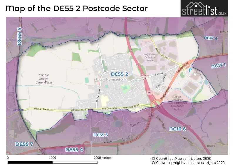
The DE55 2 postcode sector stands on the Derbyshire and Nottinghamshire border.
Did you know? According to the 2021 Census, the DE55 2 postcode sector is home to a bustling 7,945 residents!
Given that each sector allows for 400 unique postcode combinations. Letters C, I, K, M, O and V are not allowed in the last two letters of a postcode. With 142 postcodes already in use, this leaves 258 units available.
The DE55 2 postal code covers the settlement of South Normanton.
The DE55 2 Postcode shares a border with NG17 1 (SUTTON-IN-ASHFIELD), DE55 5 (Tibshelf, Newton, Blackwell), DE55 7 (ALFRETON, South Wingfield, Oakerthorpe), NG16 6 (Selston, Pinxton) and DE55 3 (South Normanton).
The sector is within the post town of ALFRETON.
DE55 2 is a postcode sector within the DE55 postcode district which is within the DE Derby postcode area.
The Royal Mail delivery office for the DE55 2 postal sector is the Alfreton Delivery Office.
The area of the DE55 2 postcode sector is 2.65 square miles which is 6.87 square kilometres or 1,696.73 square acres.
The DE55 2 postcode sector is crossed by the A38 Major A road.
The DE55 2 postcode sector is crossed by the M1 motorway.
Waterways within the DE55 2 postcode sector include the Blackwell Brook, Normanton Brook.

Map of the DE55 2 Postcode Sector
Explore the DE55 2 postcode sector by using our free interactive map.
| D | E | 5 | 5 | - | 2 | X | X |
| D | E | 5 | 5 | Space | 2 | Letter | Letter |
Official List of Streets
South Normanton (109 Streets)
Unofficial Streets or Alternative Spellings
SUTTON-IN-ASHFIELD
ALFRETON ROAD PINXTON LANE ALFTRETON OLD TUNNEL BERRISTOW MALL BLACKWELL TRAIL CARTWIGHT LANE CARTWRIGHT LANE LAWRENCE WAY PINXTON INTERCHANGE SOUTHFIELD DRIVE WINTERBANK WALKSouth Normanton
ALFRED STREET MAGNOLIA STREET PARKHOUSE DRIVE STORTH LANE WHITE ASH ROADHilcote
NEW LANEPinxton
BROOKHILL LANESomercotes
BIRCHWOOD LANEBlackwell
FORDBRIDGE LANEALFRETON
MANSFIELD ROADWeather Forecast for DE55 2
Press Button to Show Forecast for Alfreton
| Time Period | Icon | Description | Temperature | Rain Probability | Wind |
|---|---|---|---|---|---|
| 12:00 to 15:00 | Cloudy | 7.0°C (feels like 5.0°C) | 11.00% | N 9 mph | |
| 15:00 to 18:00 | Cloudy | 9.0°C (feels like 7.0°C) | 9.00% | N 7 mph | |
| 18:00 to 21:00 | Cloudy | 8.0°C (feels like 6.0°C) | 8.00% | NE 7 mph | |
| 21:00 to 00:00 | Cloudy | 6.0°C (feels like 3.0°C) | 6.00% | ENE 7 mph |
Press Button to Show Forecast for Alfreton
| Time Period | Icon | Description | Temperature | Rain Probability | Wind |
|---|---|---|---|---|---|
| 00:00 to 03:00 | Cloudy | 3.0°C (feels like 2.0°C) | 4.00% | ENE 4 mph | |
| 03:00 to 06:00 | Partly cloudy (night) | 2.0°C (feels like 0.0°C) | 2.00% | NNE 4 mph | |
| 06:00 to 09:00 | Partly cloudy (day) | 3.0°C (feels like 1.0°C) | 1.00% | NNE 4 mph | |
| 09:00 to 12:00 | Partly cloudy (day) | 6.0°C (feels like 4.0°C) | 3.00% | ENE 7 mph | |
| 12:00 to 15:00 | Overcast | 8.0°C (feels like 7.0°C) | 9.00% | ENE 4 mph | |
| 15:00 to 18:00 | Cloudy | 9.0°C (feels like 8.0°C) | 8.00% | ENE 4 mph | |
| 18:00 to 21:00 | Cloudy | 8.0°C (feels like 6.0°C) | 9.00% | ENE 7 mph | |
| 21:00 to 00:00 | Partly cloudy (night) | 5.0°C (feels like 3.0°C) | 8.00% | ENE 7 mph |
Press Button to Show Forecast for Alfreton
| Time Period | Icon | Description | Temperature | Rain Probability | Wind |
|---|---|---|---|---|---|
| 00:00 to 03:00 | Partly cloudy (night) | 4.0°C (feels like 2.0°C) | 7.00% | ENE 4 mph | |
| 03:00 to 06:00 | Partly cloudy (night) | 3.0°C (feels like 1.0°C) | 9.00% | NE 7 mph | |
| 06:00 to 09:00 | Cloudy | 4.0°C (feels like 1.0°C) | 11.00% | NE 7 mph | |
| 09:00 to 12:00 | Cloudy | 7.0°C (feels like 4.0°C) | 13.00% | ENE 9 mph | |
| 12:00 to 15:00 | Overcast | 9.0°C (feels like 6.0°C) | 21.00% | ENE 9 mph | |
| 15:00 to 18:00 | Cloudy | 9.0°C (feels like 7.0°C) | 20.00% | ENE 11 mph | |
| 18:00 to 21:00 | Cloudy | 9.0°C (feels like 6.0°C) | 21.00% | ENE 11 mph | |
| 21:00 to 00:00 | Cloudy | 7.0°C (feels like 4.0°C) | 18.00% | NE 9 mph |
Press Button to Show Forecast for Alfreton
| Time Period | Icon | Description | Temperature | Rain Probability | Wind |
|---|---|---|---|---|---|
| 00:00 to 03:00 | Overcast | 6.0°C (feels like 3.0°C) | 24.00% | NE 9 mph | |
| 03:00 to 06:00 | Light rain | 6.0°C (feels like 3.0°C) | 49.00% | NE 9 mph | |
| 06:00 to 09:00 | Light rain | 7.0°C (feels like 4.0°C) | 53.00% | NE 9 mph | |
| 09:00 to 12:00 | Heavy rain | 8.0°C (feels like 6.0°C) | 77.00% | NNE 11 mph | |
| 12:00 to 15:00 | Heavy rain | 10.0°C (feels like 8.0°C) | 76.00% | NNE 11 mph | |
| 15:00 to 18:00 | Light rain | 11.0°C (feels like 8.0°C) | 50.00% | NNE 9 mph | |
| 18:00 to 21:00 | Heavy rain shower (day) | 10.0°C (feels like 8.0°C) | 56.00% | NE 9 mph | |
| 21:00 to 00:00 | Cloudy | 8.0°C (feels like 6.0°C) | 13.00% | NE 7 mph |
Schools and Places of Education Within the DE55 2 Postcode Sector
Frederick Gent School
Academy sponsor led
Mansfield Road, Alfreton, Derbyshire, DE55 2ER
Head: Mr Christopher Woollard
Ofsted Rating: Good
Inspection: 2022-03-16 (771 days ago)
Website: Visit Frederick Gent School Website
Phone: 01773811737
Number of Pupils: 796
Glebe Junior School
Community school
Hamlet Lane, Alfreton, Derbyshire, DE55 2JB
Head: Mr Steve Watson
Ofsted Rating: Good
Inspection: 2022-07-13 (652 days ago)
Website: Visit Glebe Junior School Website
Phone: 01773811304
Number of Pupils: 391
South Normanton Nursery School
Local authority nursery school
Hamlet Lane, Alfreton, Derbyshire, DE55 2JB
Head: Mr Peter Hallsworth
Ofsted Rating: Outstanding
Inspection: 2023-07-04 (296 days ago)
Website: Visit South Normanton Nursery School Website
Phone: 01773810876
Number of Pupils: 78
The Brigg Infant School
Community school
39 South Street, Alfreton, Derbyshire, DE55 2DA
Head: Mrs Alison Spencer
Ofsted Rating: Good
Inspection: 2019-07-04 (1757 days ago)
Website: Visit The Brigg Infant School Website
Phone: 01773811317
Number of Pupils: 177
House Prices in the DE55 2 Postcode Sector
| Type of Property | 2018 Average | 2018 Sales | 2017 Average | 2017 Sales | 2016 Average | 2016 Sales | 2015 Average | 2015 Sales |
|---|---|---|---|---|---|---|---|---|
| Detached | £195,701 | 37 | £191,114 | 38 | £202,255 | 77 | £181,907 | 68 |
| Semi-Detached | £123,399 | 55 | £119,230 | 42 | £100,770 | 58 | £117,551 | 61 |
| Terraced | £86,357 | 35 | £96,635 | 26 | £81,648 | 40 | £78,273 | 30 |
| Flats | £86,398 | 3 | £60,200 | 1 | £37,333 | 3 | £56,500 | 1 |
Important Postcodes DE55 2 in the Postcode Sector
DE55 2AA is the postcode for Ground and First Floor, The Hub Joint Service Centre, Shiners Way, Ground & First Floor, The Hub Joint Service Centre, Shiners Way, and The Hub Joint Service Centre, Shiners Way
DE55 2BS is the postcode for The Green Infant School, New Street
DE55 2DA is the postcode for MAIN BUILDING, Brigg Infant School, South Street
DE55 2EG is the postcode for Whitemeadow Furniture, Langham Park, Berristow Lane
DE55 2ER is the postcode for Frederick Gent School, Mansfield Road, SPORTS HALL, Frederick Gent School, Mansfield Road, LANGUAGE BLOCK, Frederick Gent School, Mansfield Road, ADMIN AND CLASP, Frederick Gent School, Mansfield Road, and SPORTS AND TECH, Frederick Gent School, Mansfield Road
DE55 2JB is the postcode for South Normanton Nursery School, Hamlet Lane, and Glebe Junior School, Hamlet Lane
| The DE55 2 Sector is within these Local Authorities |
|
|---|---|
| The DE55 2 Sector is within these Counties |
|
| The DE55 2 Sector is within these Water Company Areas |
|