The DE56 1 postcode sector is within the county of Derbyshire.
Did you know? According to the 2021 Census, the DE56 1 postcode sector is home to a bustling 13,242 residents!
Given that each sector allows for 400 unique postcode combinations. Letters C, I, K, M, O and V are not allowed in the last two letters of a postcode. With 286 postcodes already in use, this leaves 114 units available.
The DE56 1 postal code covers the settlement of BELPER.
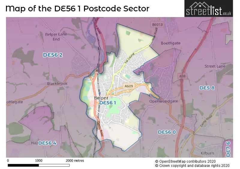
The DE56 1 Postcode shares a border with DE56 0 (BELPER, Kilburn, Milford) and DE56 2 (BELPER, Ambergate, Heage).
The sector is within the post town of BELPER.
DE56 1 is a postcode sector within the DE56 postcode district which is within the DE Derby postcode area.
The Royal Mail delivery office for the DE56 1 postal sector is the Belper Delivery Office.
The area of the DE56 1 postcode sector is 2.20 square miles which is 5.70 square kilometres or 1,407.49 square acres.
Waterways within the DE56 1 postcode sector include the River Derwent.

Map of the DE56 1 Postcode Sector
Explore the DE56 1 postcode sector by using our free interactive map.
| D | E | 5 | 6 | - | 1 | X | X |
| D | E | 5 | 6 | Space | 1 | Letter | Letter |
Official List of Streets
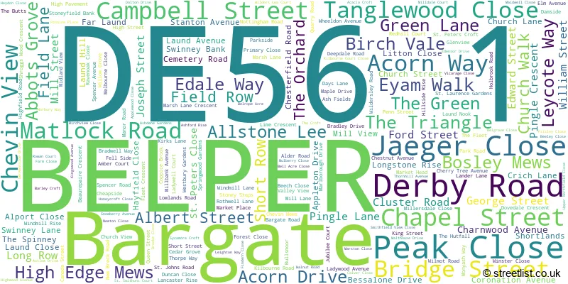
BELPER (213 Streets)
Unofficial Streets or Alternative Spellings
Heage
NEW ROADBELPER
ALTON ROAD ARKWRIGHT AVENUE BARGATE CLOSE BOBBIN WAY BROADHOLME LANE DALTON ROAD GREGORYS WAY JOHN OGAUNTS WAY SANDBED LANE WHITEMOOR LANE BELLROPE ACRE BORDER COTTAGES BROOK CLOSE BROOK SIDE BULLFINCH CLOSE CAMPBELL STREET COURT CLUSTERS COURT CROWN TERRACE DERWENT COURT DERWENT VALE DOVEDALE COURT FLEET PARK GOODS YARD JACKSONS LANE LAUND FARM MEWS LAWN FARM COURT MEADOW COURT PARK SIDE PINCHOMS HILL ROAD ROWEN COURT SHORT LANDS ST GEORGES PLACE TANGLEWOOD THORNTON WAY WELL YARDBargate
BELPER ROADAmbergate
CRICH LANEMilford
DERBY ROAD DERWENT AVENUEWeather Forecast for DE56 1
Press Button to Show Forecast for Belper
| Time Period | Icon | Description | Temperature | Rain Probability | Wind |
|---|---|---|---|---|---|
| 18:00 to 21:00 | Light rain | 8.0°C (feels like 6.0°C) | 47.00% | NW 7 mph | |
| 21:00 to 00:00 | Partly cloudy (night) | 5.0°C (feels like 3.0°C) | 1.00% | WNW 7 mph |
Press Button to Show Forecast for Belper
| Time Period | Icon | Description | Temperature | Rain Probability | Wind |
|---|---|---|---|---|---|
| 00:00 to 03:00 | Clear night | 5.0°C (feels like 1.0°C) | 3.00% | WNW 9 mph | |
| 03:00 to 06:00 | Clear night | 4.0°C (feels like 0.0°C) | 2.00% | NW 11 mph | |
| 06:00 to 09:00 | Sunny day | 3.0°C (feels like -1.0°C) | 2.00% | NW 9 mph | |
| 09:00 to 12:00 | Sunny day | 7.0°C (feels like 4.0°C) | 1.00% | NW 13 mph | |
| 12:00 to 15:00 | Overcast | 9.0°C (feels like 6.0°C) | 8.00% | NW 16 mph | |
| 15:00 to 18:00 | Light rain | 9.0°C (feels like 7.0°C) | 50.00% | NW 13 mph | |
| 18:00 to 21:00 | Light rain shower (day) | 7.0°C (feels like 4.0°C) | 40.00% | NNW 11 mph | |
| 21:00 to 00:00 | Clear night | 5.0°C (feels like 2.0°C) | 2.00% | NNW 7 mph |
Press Button to Show Forecast for Belper
| Time Period | Icon | Description | Temperature | Rain Probability | Wind |
|---|---|---|---|---|---|
| 00:00 to 03:00 | Partly cloudy (night) | 4.0°C (feels like 1.0°C) | 2.00% | N 7 mph | |
| 03:00 to 06:00 | Clear night | 3.0°C (feels like 0.0°C) | 2.00% | NNW 7 mph | |
| 06:00 to 09:00 | Sunny day | 3.0°C (feels like 1.0°C) | 3.00% | NW 4 mph | |
| 09:00 to 12:00 | Cloudy | 8.0°C (feels like 6.0°C) | 6.00% | W 4 mph | |
| 12:00 to 15:00 | Overcast | 10.0°C (feels like 8.0°C) | 11.00% | W 9 mph | |
| 15:00 to 18:00 | Overcast | 11.0°C (feels like 8.0°C) | 17.00% | W 11 mph | |
| 18:00 to 21:00 | Cloudy | 9.0°C (feels like 7.0°C) | 18.00% | W 11 mph | |
| 21:00 to 00:00 | Cloudy | 8.0°C (feels like 5.0°C) | 15.00% | WSW 11 mph |
Press Button to Show Forecast for Belper
| Time Period | Icon | Description | Temperature | Rain Probability | Wind |
|---|---|---|---|---|---|
| 00:00 to 03:00 | Cloudy | 8.0°C (feels like 5.0°C) | 14.00% | W 13 mph | |
| 03:00 to 06:00 | Cloudy | 8.0°C (feels like 5.0°C) | 6.00% | WNW 13 mph | |
| 06:00 to 09:00 | Cloudy | 8.0°C (feels like 5.0°C) | 6.00% | WNW 13 mph | |
| 09:00 to 12:00 | Partly cloudy (day) | 10.0°C (feels like 6.0°C) | 5.00% | NW 16 mph | |
| 12:00 to 15:00 | Cloudy | 11.0°C (feels like 8.0°C) | 9.00% | NW 16 mph | |
| 15:00 to 18:00 | Cloudy | 12.0°C (feels like 9.0°C) | 7.00% | NW 16 mph | |
| 18:00 to 21:00 | Cloudy | 10.0°C (feels like 8.0°C) | 5.00% | NNW 11 mph | |
| 21:00 to 00:00 | Cloudy | 8.0°C (feels like 5.0°C) | 4.00% | N 9 mph |
Press Button to Show Forecast for Belper
| Time Period | Icon | Description | Temperature | Rain Probability | Wind |
|---|---|---|---|---|---|
| 00:00 to 03:00 | Cloudy | 6.0°C (feels like 4.0°C) | 4.00% | N 7 mph | |
| 03:00 to 06:00 | Partly cloudy (night) | 5.0°C (feels like 3.0°C) | 2.00% | N 7 mph | |
| 06:00 to 09:00 | Partly cloudy (day) | 5.0°C (feels like 3.0°C) | 2.00% | NNW 7 mph | |
| 09:00 to 12:00 | Partly cloudy (day) | 8.0°C (feels like 6.0°C) | 1.00% | N 7 mph | |
| 12:00 to 15:00 | Partly cloudy (day) | 11.0°C (feels like 9.0°C) | 1.00% | N 7 mph | |
| 15:00 to 18:00 | Cloudy | 12.0°C (feels like 11.0°C) | 5.00% | NNW 7 mph | |
| 18:00 to 21:00 | Partly cloudy (day) | 12.0°C (feels like 10.0°C) | 2.00% | N 7 mph | |
| 21:00 to 00:00 | Partly cloudy (night) | 8.0°C (feels like 6.0°C) | 1.00% | NNW 7 mph |
Schools and Places of Education Within the DE56 1 Postcode Sector
Herbert Strutt Primary School
Community school
Thornhill Avenue, Belper, Derbyshire, DE56 1SH
Head: Mrs Sarah Core
Ofsted Rating: Good
Inspection: 2023-10-19 (180 days ago)
Website: Visit Herbert Strutt Primary School Website
Phone: 01773822771
Number of Pupils: 192
Long Row Primary School
Community school
Long Row, Belper, Derbyshire, DE56 1DR
Head: Mrs Lisa White
Ofsted Rating: Good
Inspection: 2018-06-05 (2142 days ago)
Website: Visit Long Row Primary School Website
Phone: 01773823319
Number of Pupils: 251
Pottery Primary School
Community school
Kilbourne Road, Belper, Derbyshire, DE56 1HA
Head: Mrs Elizabeth Peach
Ofsted Rating: Requires improvement
Inspection: 2023-11-30 (138 days ago)
Website: Visit Pottery Primary School Website
Phone: 01773823383
Number of Pupils: 318
St John's CofE Primary School and Nursery
Voluntary controlled school
Laund Nook, Belper, Derbyshire, DE56 1GY
Head: Mr Roger Averis
Ofsted Rating: Good
Inspection: 2023-02-15 (426 days ago)
Website: Visit St John's CofE Primary School and Nursery Website
Phone: 01773822995
Number of Pupils: 428
House Prices in the DE56 1 Postcode Sector
| Type of Property | 2018 Average | 2018 Sales | 2017 Average | 2017 Sales | 2016 Average | 2016 Sales | 2015 Average | 2015 Sales |
|---|---|---|---|---|---|---|---|---|
| Detached | £252,460 | 91 | £229,782 | 60 | £221,358 | 103 | £190,290 | 91 |
| Semi-Detached | £197,110 | 101 | £171,751 | 85 | £167,759 | 76 | £151,673 | 91 |
| Terraced | £165,851 | 88 | £146,988 | 93 | £150,240 | 118 | £139,343 | 119 |
| Flats | £138,376 | 21 | £130,430 | 15 | £133,194 | 19 | £119,835 | 27 |
Important Postcodes DE56 1 in the Postcode Sector
DE56 1AY is the postcode for Riversdale Surgery, 59 Bridge Street, and Riversdale Surgery, 57 Bridge Street
DE56 1BA is the postcode for Derbyshire County Council, Belper Library, Bridge Street
DE56 1DE is the postcode for Ada Belfield Home, Field Lane
DE56 1DR is the postcode for MAIN SCHOOL, Belper Long Row Primary School, Long Row, and KITCHEN HALL YEAR 5/6, Belper Long Row Primary School, Long Row
DE56 1GY is the postcode for St Johns C of E Primary School and Nursery, Laund Nook, MAIN BUILDING, St Johns C of E Primary School and Nursery, Laund Nook, BLOCK F, St Johns C of E Primary School & Nursery, Laund Nook, and Main Building, St Johns C of E Primary School & Nursery, Laund Nook
DE56 1HA is the postcode for BLOCK D, Pottery Primary School, Kilbourne Road, and A & B BLOCK (INCORPORATING LIBRARY), Pottery Primary School, Kilbourne Road
DE56 1PA is the postcode for Belper Adult Community Education Centre, Holbrook Road
DE56 1RZ is the postcode for Belper School, Kilbourne Road
DE56 1SH is the postcode for Herbert Strutt Primary School, Thornhill Avenue, and Main Building, Herbert Strutt Primary School, Thornhill Avenue
DE56 1UQ is the postcode for Whole Building, Ada Belfield Centre and Belper Library, Derwent Street
DE56 1UU is the postcode for Royal Mail, Belper Delivery Office, Goods Road, and Derbyshire Healthcare NHS Trust, Iduna House, Goods Road
DE56 1WH is the postcode for BABINGTON HOSPITAL, DERBY ROAD, BELPER, Belper Clinic, Derby Road, and Babington Hospital, Derby Road
DE56 1WN is the postcode for Unity Mill, Derwent Street
| The DE56 1 Sector is within these Local Authorities |
|
|---|---|
| The DE56 1 Sector is within these Counties |
|
| The DE56 1 Sector is within these Water Company Areas |
|
Tourist Attractions within the DE56 1 Postcode Area
We found 1 visitor attractions within the DE56 postcode area
| Strutt's North Mill |
|---|
| Museums & Art Galleries |
| Museum and / or Art Gallery |
| View Strutt's North Mill on Google Maps |