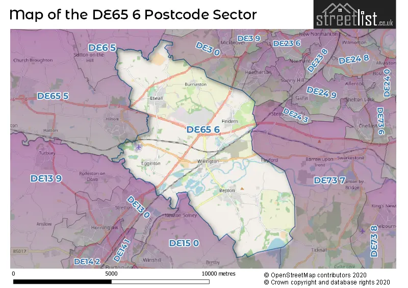
The DE65 6 postcode sector stands on the Derbyshire and Staffordshire border.
Did you know? According to the 2021 Census, the DE65 6 postcode sector is home to a bustling 12,176 residents!
Given that each sector allows for 400 unique postcode combinations. Letters C, I, K, M, O and V are not allowed in the last two letters of a postcode. With 274 postcodes already in use, this leaves 126 units available.
The largest settlement in the DE65 6 postal code is Willington followed by Etwall, and Repton.
The DE65 6 Postcode shares a border with DE6 5 (Dalbury Lees, Doveridge, Sutton-on-the-Hill), DE13 0 (BURTON-ON-TRENT, Stretton), DE13 9 (Tutbury, Rolleston-on-Dove, BURTON-ON-TRENT), DE15 0 (BURTON-ON-TRENT, Bretby, Newton Solney), DE65 5 (Hilton, Hatton, Foston), DE3 0 (Mickleover), DE23 3 (Littleover), DE23 2 (Littleover), DE23 4 (Littleover) and DE73 7 (Ticknall, Barrow-on-Trent, Stanton-by-Bridge).
The sector is within the post town of DERBY.
DE65 6 is a postcode sector within the DE65 postcode district which is within the DE Derby postcode area.
The Royal Mail delivery office for the DE65 6 postal sector is the Hatton Delivery Office.
The area of the DE65 6 postcode sector is 21.63 square miles which is 56.03 square kilometres or 13,845.18 square acres.
The DE65 6 postcode sector is crossed by the A38 Major A road.
The DE65 6 postcode sector is crossed by the A50 Major A road.
Waterways within the DE65 6 postcode sector include the River Dove, River Trent, Trent & Mersey Canal, Repton Brook, The Old Trent.

Map of the DE65 6 Postcode Sector
Explore the DE65 6 postcode sector by using our free interactive map.
| D | E | 6 | 5 | - | 6 | X | X |
| D | E | 6 | 5 | Space | 6 | Letter | Letter |
Official List of Streets
Findern (37 Streets)
Etwall (57 Streets)
Willington (56 Streets)
Repton (42 Streets)
Egginton (16 Streets)
Burnaston (8 Streets)
Unofficial Streets or Alternative Spellings
Repton
RICHMOND COURTBarrow-on-Trent
TWYFORD ROADHilton
DERBY ROAD EGGINTON ROAD RUTLAND CLOSE WILLOWPIT LANELittleover
RYKNELD ROADMickleover
STAKER LANENewton Solney
REPTON ROADWeather Forecast for DE65 6
Press Button to Show Forecast for Burton Upon Trent
| Time Period | Icon | Description | Temperature | Rain Probability | Wind |
|---|---|---|---|---|---|
| 15:00 to 18:00 | Cloudy | 11.0°C (feels like 9.0°C) | 4.00% | N 7 mph | |
| 18:00 to 21:00 | Cloudy | 10.0°C (feels like 9.0°C) | 4.00% | N 4 mph | |
| 21:00 to 00:00 | Cloudy | 7.0°C (feels like 5.0°C) | 4.00% | WNW 7 mph |
Press Button to Show Forecast for Burton Upon Trent
| Time Period | Icon | Description | Temperature | Rain Probability | Wind |
|---|---|---|---|---|---|
| 00:00 to 03:00 | Partly cloudy (night) | 4.0°C (feels like 3.0°C) | 1.00% | W 4 mph | |
| 03:00 to 06:00 | Cloudy | 4.0°C (feels like 2.0°C) | 6.00% | WSW 4 mph | |
| 06:00 to 09:00 | Overcast | 5.0°C (feels like 3.0°C) | 9.00% | WSW 7 mph | |
| 09:00 to 12:00 | Cloudy | 8.0°C (feels like 5.0°C) | 8.00% | WNW 9 mph | |
| 12:00 to 15:00 | Light rain | 9.0°C (feels like 7.0°C) | 39.00% | NNW 9 mph | |
| 15:00 to 18:00 | Cloudy | 9.0°C (feels like 8.0°C) | 10.00% | NNW 7 mph | |
| 18:00 to 21:00 | Cloudy | 9.0°C (feels like 8.0°C) | 10.00% | N 4 mph | |
| 21:00 to 00:00 | Cloudy | 7.0°C (feels like 5.0°C) | 8.00% | E 7 mph |
Press Button to Show Forecast for Burton Upon Trent
| Time Period | Icon | Description | Temperature | Rain Probability | Wind |
|---|---|---|---|---|---|
| 00:00 to 03:00 | Cloudy | 5.0°C (feels like 3.0°C) | 5.00% | E 4 mph | |
| 03:00 to 06:00 | Cloudy | 3.0°C (feels like 2.0°C) | 4.00% | ENE 4 mph | |
| 06:00 to 09:00 | Cloudy | 4.0°C (feels like 2.0°C) | 4.00% | NE 4 mph | |
| 09:00 to 12:00 | Cloudy | 7.0°C (feels like 5.0°C) | 5.00% | ENE 7 mph | |
| 12:00 to 15:00 | Overcast | 9.0°C (feels like 8.0°C) | 9.00% | E 4 mph | |
| 15:00 to 18:00 | Cloudy | 10.0°C (feels like 9.0°C) | 8.00% | ENE 4 mph | |
| 18:00 to 21:00 | Cloudy | 9.0°C (feels like 8.0°C) | 10.00% | ENE 7 mph | |
| 21:00 to 00:00 | Cloudy | 6.0°C (feels like 4.0°C) | 10.00% | ENE 7 mph |
Press Button to Show Forecast for Burton Upon Trent
| Time Period | Icon | Description | Temperature | Rain Probability | Wind |
|---|---|---|---|---|---|
| 00:00 to 03:00 | Partly cloudy (night) | 5.0°C (feels like 3.0°C) | 8.00% | ENE 7 mph | |
| 03:00 to 06:00 | Cloudy | 4.0°C (feels like 2.0°C) | 13.00% | ENE 7 mph | |
| 06:00 to 09:00 | Cloudy | 5.0°C (feels like 2.0°C) | 12.00% | ENE 7 mph | |
| 09:00 to 12:00 | Overcast | 8.0°C (feels like 5.0°C) | 17.00% | ENE 9 mph | |
| 12:00 to 15:00 | Overcast | 9.0°C (feels like 7.0°C) | 23.00% | ENE 11 mph | |
| 15:00 to 18:00 | Overcast | 10.0°C (feels like 8.0°C) | 23.00% | ENE 11 mph | |
| 18:00 to 21:00 | Cloudy | 10.0°C (feels like 8.0°C) | 19.00% | ENE 9 mph | |
| 21:00 to 00:00 | Cloudy | 8.0°C (feels like 6.0°C) | 22.00% | NE 11 mph |
Press Button to Show Forecast for Burton Upon Trent
| Time Period | Icon | Description | Temperature | Rain Probability | Wind |
|---|---|---|---|---|---|
| 00:00 to 03:00 | Overcast | 7.0°C (feels like 5.0°C) | 26.00% | NE 9 mph | |
| 03:00 to 06:00 | Overcast | 7.0°C (feels like 4.0°C) | 25.00% | NE 9 mph | |
| 06:00 to 09:00 | Light rain | 7.0°C (feels like 5.0°C) | 55.00% | NE 9 mph | |
| 09:00 to 12:00 | Heavy rain | 9.0°C (feels like 7.0°C) | 77.00% | NE 9 mph | |
| 12:00 to 15:00 | Heavy rain | 11.0°C (feels like 9.0°C) | 75.00% | ENE 9 mph | |
| 15:00 to 18:00 | Light rain | 11.0°C (feels like 9.0°C) | 55.00% | NE 9 mph | |
| 18:00 to 21:00 | Heavy rain shower (day) | 11.0°C (feels like 9.0°C) | 52.00% | ENE 9 mph | |
| 21:00 to 00:00 | Cloudy | 9.0°C (feels like 7.0°C) | 12.00% | ESE 7 mph |
Schools and Places of Education Within the DE65 6 Postcode Sector
Egginton Primary School
Community school
Church Road, Derby, Derbyshire, DE65 6HP
Head: Mr Jason Cunningham
Ofsted Rating: Good
Inspection: 2023-05-11 (349 days ago)
Website: Visit Egginton Primary School Website
Phone: 01283732748
Number of Pupils: 60
Etwall Primary School
Community school
Egginton Road, Derby, Derbyshire, DE65 6NB
Head: Mrs Sarah Bentley
Ofsted Rating: Good
Inspection: 2023-02-08 (441 days ago)
Website: Visit Etwall Primary School Website
Phone: 01283732301
Number of Pupils: 313
Findern Primary School
Community school
Buckford Lane, Derby, Derbyshire, DE65 6AR
Head: Mrs Paula Fox
Ofsted Rating: Good
Inspection: 2018-09-12 (2051 days ago)
Website: Visit Findern Primary School Website
Phone: 01283702150
Number of Pupils: 207
John Port Spencer Academy
Academy sponsor led
Main Street, Derby, Derbyshire, DE65 6LU
Head: Mrs Alison Vann (Acting Principal)
Ofsted Rating: Good
Inspection: 2022-05-18 (707 days ago)
Website: Visit John Port Spencer Academy Website
Phone: 01283734111
Number of Pupils: 1929
Longdon Park School
Other independent special school
Park Hill, Derbyshire, , DE65 6GU
Head: Headteacher Richard George
Ofsted Rating: Good
Inspection: 2021-11-18 (888 days ago)
Website: Visit Longdon Park School Website
Phone: 01283733195
Number of Pupils: 65
Repton Primary School
Community school
Springfield Road, Derby, Derbyshire, DE65 6GN
Head: Mr Steve Tague
Ofsted Rating: Good
Inspection: 2019-03-22 (1860 days ago)
Website: Visit Repton Primary School Website
Phone: 01283703732
Number of Pupils: 206
Willington Primary School
Community school
Trent Avenue, Derby, Derbyshire, DE65 6DN
Head: Mrs Kate Spencer Lovesey
Ofsted Rating: Outstanding
Inspection: 2012-11-14 (4179 days ago)
Website: Visit Willington Primary School Website
Phone: 01283702156
Number of Pupils: 212
House Prices in the DE65 6 Postcode Sector
| Type of Property | 2018 Average | 2018 Sales | 2017 Average | 2017 Sales | 2016 Average | 2016 Sales | 2015 Average | 2015 Sales |
|---|---|---|---|---|---|---|---|---|
| Detached | £335,484 | 143 | £360,515 | 160 | £317,156 | 139 | £322,976 | 120 |
| Semi-Detached | £216,010 | 68 | £209,364 | 77 | £196,741 | 65 | £185,785 | 58 |
| Terraced | £182,477 | 24 | £195,094 | 26 | £183,671 | 29 | £155,903 | 42 |
| Flats | £226,000 | 1 | £136,750 | 2 | £151,417 | 6 | £124,833 | 3 |
Important Postcodes DE65 6 in the Postcode Sector
DE65 6AR is the postcode for Findern Community Primary School, Heath Lane
DE65 6DN is the postcode for Willington Primary School, Trent Avenue, and Willington Primary School, Trent Avenue, Willington
DE65 6GN is the postcode for MAIN BUILDING, Repton Primary School, Springfield Road
DE65 6GS is the postcode for The Dales, Fisher Close
DE65 6HZ is the postcode for Etwall Leisure Centre, Hilton Road, ETWALL LEISURE CENTRE, HILTON ROAD, ETWALL, and SQUASH COURTS BUILDING, Etwall Leisure Centre, Hilton Road
DE65 6LU is the postcode for HATHERSAGE, John Port Spencer Academy, Main Street, CHATSWORTH & FLAMSTEAD, John Port Spencer Academy, Main Street, OLD DERWENT, John Port Spencer Academy, Main Street, OLD DERWENT, John Port School, Main Street, BAKEWELL & DERWENT, John Port Spencer Academy, Main Street, FLAMSTEAD-M, John Port Spencer Academy, Main Street, EDALE, John Port Spencer Academy, Main Street, CHATSWORTH, John Port School, Main Street, ENGLISH BUILDING, John Port Spencer Academy, Main Street, ASHBOURNE, John Port School, Main Street, ASHBOURNE, John Port Spencer Academy, Main Street, BAKEWELL, John Port Spencer Academy, Main Street, Edale Block, John Port Spencer Academy, Main Street, FLAMSTEAD-U, John Port Spencer Academy, Main Street, NEW DERWENT, John Port Spencer Academy, Main Street, BUSINESS STUDIES, John Port Spencer Academy, Main Street, JUBILEE, John Port Spencer Academy, Main Street, FLAMSTEAD-L, John Port Spencer Academy, Main Street, NEW SCIENCE BUILDING, John Port Spencer Academy, Main Street, EDALE, John Port School, Main Street, John Port Spencer Academy, Main Street, BAKEWELL, John Port School, Main Street, CHATSWORTH, John Port Spencer Academy, Main Street, SIXTH FORM, John Port Spencer Academy, Main Street, SIXTH FORM BUSINESS, John Port Spencer Academy, Main Street, and TOYOTA, John Port Spencer Academy, Main Street
DE65 6NB is the postcode for MAIN BUILDING, Etwall Primary School, Egginton Road
DE65 6SH is the postcode for REPTON HEALTH CENTRE,, ASKEW GROVE,, and 64 Askew Grove, Repton
| The DE65 6 Sector is within these Local Authorities |
|
|---|---|
| The DE65 6 Sector is within these Counties |
|
| The DE65 6 Sector is within these Water Company Areas |
|