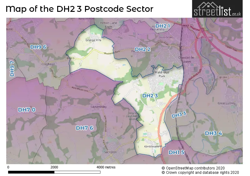
The DH2 3 postcode sector is within the county of Durham.
Did you know? According to the 2021 Census, the DH2 3 postcode sector is home to a bustling 8,972 residents!
Given that each sector allows for 400 unique postcode combinations. Letters C, I, K, M, O and V are not allowed in the last two letters of a postcode. With 232 postcodes already in use, this leaves 168 units available.
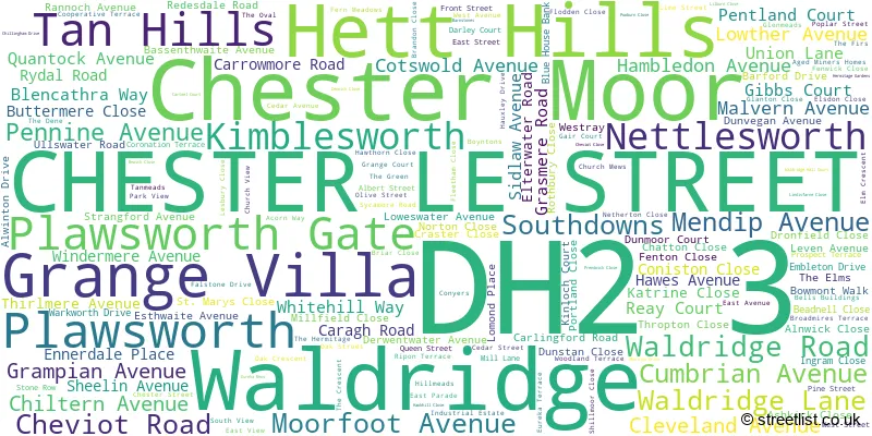
The largest settlement in the DH2 3 postal code is CHESTER LE STREET followed by Grange Villa, and Nettlesworth.
The DH2 3 Postcode shares a border with DH1 5 (DURHAM, Pity Me, Aykley Heads), DH2 1 (Pelton, Ouston, Birtley), DH3 3 (CHESTER LE STREET), DH2 2 (CHESTER LE STREET, Pelton Fell, Newfield), DH7 6 (Sacriston, Witton Gilbert, Edmondsley) and DH9 6 (STANLEY, Craghead, West Pelton).
The sector is within the post town of CHESTER LE STREET.
DH2 3 is a postcode sector within the DH2 postcode district which is within the DH Durham postcode area.
The Royal Mail delivery office for the DH2 3 postal sector is the Chester Le Street Delivery Office.
The area of the DH2 3 postcode sector is 4.06 square miles which is 10.51 square kilometres or 2,596.62 square acres.

Map of the DH2 3 Postcode Sector
Explore the DH2 3 postcode sector by using our free interactive map.
| D | H | 2 | - | 3 | X | X |
| D | H | 2 | Space | 3 | Letter | Letter |
Official List of Streets
CHESTER LE STREET (96 Streets)
Nettlesworth (15 Streets)
Chester Moor (9 Streets)
Tan Hills (3 Streets)
Grange Villa (10 Streets)
Plawsworth (4 Streets)
Hett Hills (1 Streets)
Kimblesworth (12 Streets)
Waldridge (9 Streets)
Plawsworth Gate (2 Streets)
Unofficial Streets or Alternative Spellings
Plawsworth
HOLMHILL LANE BEANEY LANE BEECHGROVE LANE BLUEHOUSE BANK CRAGHEAD LANE HUMBLEBURN LANE NEWBRIDGE BANKS OLD WALDRIDGE PLAWSWORTH FARM SOUTH APPROACH UGLY LANE WALDRIDGE LINK ROAD WALDRIDGE PARK WALDRIDGE PARK ROUNDABOUT WHEATLEYWELL LANECHESTER LE STREET
AUCKLAND BRANTWOOD GRAY AVENUE SECOND AVENUE YETHOLM AVENUEPelton
PELTON LANEWeather Forecast for DH2 3
Press Button to Show Forecast for Sacriston
| Time Period | Icon | Description | Temperature | Rain Probability | Wind |
|---|---|---|---|---|---|
| 09:00 to 12:00 | Cloudy | 5.0°C (feels like 2.0°C) | 15.00% | N 11 mph | |
| 12:00 to 15:00 | Cloudy | 6.0°C (feels like 3.0°C) | 34.00% | N 11 mph | |
| 15:00 to 18:00 | Cloudy | 6.0°C (feels like 4.0°C) | 11.00% | NNE 9 mph | |
| 18:00 to 21:00 | Partly cloudy (day) | 6.0°C (feels like 3.0°C) | 1.00% | NNE 9 mph | |
| 21:00 to 00:00 | Cloudy | 3.0°C (feels like 1.0°C) | 3.00% | N 4 mph |
Press Button to Show Forecast for Sacriston
| Time Period | Icon | Description | Temperature | Rain Probability | Wind |
|---|---|---|---|---|---|
| 00:00 to 03:00 | Cloudy | 2.0°C (feels like 0.0°C) | 5.00% | NW 4 mph | |
| 03:00 to 06:00 | Cloudy | 2.0°C (feels like -1.0°C) | 7.00% | NW 4 mph | |
| 06:00 to 09:00 | Cloudy | 3.0°C (feels like 0.0°C) | 6.00% | NNW 4 mph | |
| 09:00 to 12:00 | Overcast | 5.0°C (feels like 3.0°C) | 9.00% | NNE 7 mph | |
| 12:00 to 15:00 | Overcast | 7.0°C (feels like 5.0°C) | 14.00% | ENE 7 mph | |
| 15:00 to 18:00 | Cloudy | 7.0°C (feels like 5.0°C) | 10.00% | E 7 mph | |
| 18:00 to 21:00 | Partly cloudy (day) | 6.0°C (feels like 4.0°C) | 5.00% | E 7 mph | |
| 21:00 to 00:00 | Partly cloudy (night) | 3.0°C (feels like 1.0°C) | 2.00% | E 4 mph |
Press Button to Show Forecast for Sacriston
| Time Period | Icon | Description | Temperature | Rain Probability | Wind |
|---|---|---|---|---|---|
| 00:00 to 03:00 | Partly cloudy (night) | 1.0°C (feels like -1.0°C) | 2.00% | SE 2 mph | |
| 03:00 to 06:00 | Partly cloudy (night) | 1.0°C (feels like -1.0°C) | 4.00% | SSE 4 mph | |
| 06:00 to 09:00 | Partly cloudy (day) | 3.0°C (feels like 2.0°C) | 5.00% | E 4 mph | |
| 09:00 to 12:00 | Cloudy | 7.0°C (feels like 5.0°C) | 11.00% | E 7 mph | |
| 12:00 to 15:00 | Overcast | 8.0°C (feels like 5.0°C) | 16.00% | E 9 mph | |
| 15:00 to 18:00 | Cloudy | 8.0°C (feels like 6.0°C) | 12.00% | E 9 mph | |
| 18:00 to 21:00 | Cloudy | 7.0°C (feels like 4.0°C) | 11.00% | E 9 mph | |
| 21:00 to 00:00 | Cloudy | 5.0°C (feels like 2.0°C) | 12.00% | ENE 7 mph |
Press Button to Show Forecast for Sacriston
| Time Period | Icon | Description | Temperature | Rain Probability | Wind |
|---|---|---|---|---|---|
| 00:00 to 03:00 | Cloudy | 4.0°C (feels like 2.0°C) | 16.00% | NE 7 mph | |
| 03:00 to 06:00 | Light rain | 5.0°C (feels like 2.0°C) | 45.00% | NNE 9 mph | |
| 06:00 to 09:00 | Light rain | 5.0°C (feels like 3.0°C) | 47.00% | N 9 mph | |
| 09:00 to 12:00 | Heavy rain | 7.0°C (feels like 4.0°C) | 70.00% | NE 11 mph | |
| 12:00 to 15:00 | Cloudy | 9.0°C (feels like 6.0°C) | 24.00% | NE 11 mph | |
| 15:00 to 18:00 | Cloudy | 9.0°C (feels like 7.0°C) | 25.00% | NE 11 mph | |
| 18:00 to 21:00 | Light rain shower (day) | 9.0°C (feels like 7.0°C) | 41.00% | N 9 mph | |
| 21:00 to 00:00 | Cloudy | 6.0°C (feels like 4.0°C) | 13.00% | ENE 7 mph |
Schools and Places of Education Within the DH2 3 Postcode Sector
Nettlesworth Primary School
Community school
Front Street, Chester le Street, County Durham, DH2 3PF
Head: Mrs Donna Lee
Ofsted Rating: Good
Inspection: 2023-07-04 (296 days ago)
Website: Visit Nettlesworth Primary School Website
Phone: 01913710444
Number of Pupils: 113
Newker Primary School
Community school
Waldridge Road, Chester le Street, County Durham, DH2 3AA
Head: Mrs Melanie Kirkland
Ofsted Rating: Good
Inspection: 2020-02-27 (1519 days ago)
Website: Visit Newker Primary School Website
Phone: 01913887099
Number of Pupils: 414
House Prices in the DH2 3 Postcode Sector
| Type of Property | 2018 Average | 2018 Sales | 2017 Average | 2017 Sales | 2016 Average | 2016 Sales | 2015 Average | 2015 Sales |
|---|---|---|---|---|---|---|---|---|
| Detached | £293,108 | 37 | £252,943 | 38 | £248,246 | 41 | £229,962 | 37 |
| Semi-Detached | £144,162 | 28 | £144,976 | 31 | £139,646 | 27 | £144,074 | 33 |
| Terraced | £113,749 | 69 | £97,422 | 58 | £87,020 | 56 | £90,853 | 50 |
| Flats | £80,000 | 12 | £92,066 | 16 | £91,188 | 16 | £97,579 | 14 |
Important Postcodes DH2 3 in the Postcode Sector
DH2 3AA is the postcode for Newker Primary School, Waldridge Road
DH2 3AD is the postcode for MAIN BLOCK, The Hermitage Academy, Waldridge Lane, 6TH FORM, The Hermitage Academy, Waldridge Lane, The Hermitage Academy, Waldridge Lane, SPORTS AND DRAMA BLOCK, The Hermitage Academy, Waldridge Lane, and YEAR 7 TEACHING BLOCK, The Hermitage Academy, Waldridge Lane
DH2 3AS is the postcode for Mendip House, Mendip Avenue
DH2 3PF is the postcode for Nettlesworth Primary School, Nettlesworth
| The DH2 3 Sector is within these Local Authorities |
|
|---|---|
| The DH2 3 Sector is within these Counties |
|
| The DH2 3 Sector is within these Water Company Areas |
|