The DH3 postcode district is a postal district located in the DH Durham postcode area with a population of 26,738 residents according to the 2021 England and Wales Census.
The area of the DH3 postcode district is 11.17 square miles which is 28.94 square kilometres or 7,151.80 acres.
Currently, the DH3 district has about 765 postcode units spread across 4 geographic postcode sectors.
Given that each sector allows for 400 unique postcode combinations, the district has a capacity of 1,600 postcodes. With 765 postcodes already in use, this leaves 835 units available.
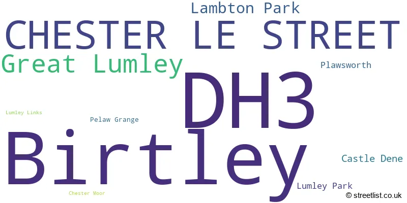
The largest settlement in the DH3 postal code is Birtley followed by CHESTER LE STREET, and Great Lumley.
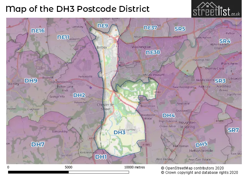
The DH3 Postcode shares a border with DH1 (DURHAM, Pity Me, High Shincliffe), DH4 (HOUGHTON LE SPRING, West Rainton, Penshaw), NE9 (GATESHEAD, Low Fell, Springwell), NE38 (WASHINGTON) and DH2 (CHESTER LE STREET, Pelton, Ouston).
The primary settlement in the DH3 postcode district is Birtley, located in the county of Tyne & Wear. The other significant settlements in this district include Chester-le-Street, Pelaw Grange, Castle Dene, Chester Moor, Great Lumley, Lambton Park, Lumley Links, and Plawsworth. The postal town with the highest postcode count in this district is Chester-le-Street.
For the district DH3, we have data on 5 postcode sectors. Here's a breakdown: The sector DH3 1, covers Birtley in Tyne & Wear. The sector DH3 2, covers Birtley in Tyne & Wear. The sector DH3 3, covers Chester Le Street in Durham. The sector DH3 4, covers Great Lumley and Chester Le Street and Lambton Park in Durham. The sector DH3 9 is non-geographic. It's often designated for PO Boxes, large organisations, or special services.

Map of the DH3 Postcode District
Explore the DH3 postcode district by using our free interactive map.
When it comes to local government, postal geography often disregards political borders. However, for a breakdown in the DH3 District: the district mostly encompasses the County Durham (420 postcodes), and finally, the Gateshead District (B) area (352 postcodes).
Weather Forecast for DH3
Press Button to Show Forecast for Chester-Le-Street
| Time Period | Icon | Description | Temperature | Rain Probability | Wind |
|---|---|---|---|---|---|
| 09:00 to 12:00 | Overcast | 6.0°C (feels like 3.0°C) | 9.00% | N 13 mph | |
| 12:00 to 15:00 | Cloudy | 8.0°C (feels like 5.0°C) | 4.00% | N 11 mph | |
| 15:00 to 18:00 | Cloudy | 8.0°C (feels like 5.0°C) | 4.00% | NNE 11 mph | |
| 18:00 to 21:00 | Cloudy | 7.0°C (feels like 5.0°C) | 5.00% | E 7 mph | |
| 21:00 to 00:00 | Cloudy | 6.0°C (feels like 4.0°C) | 5.00% | SW 7 mph |
Press Button to Show Forecast for Chester-Le-Street
| Time Period | Icon | Description | Temperature | Rain Probability | Wind |
|---|---|---|---|---|---|
| 00:00 to 03:00 | Cloudy | 6.0°C (feels like 3.0°C) | 6.00% | W 9 mph | |
| 03:00 to 06:00 | Cloudy | 5.0°C (feels like 2.0°C) | 20.00% | WNW 9 mph | |
| 06:00 to 09:00 | Cloudy | 5.0°C (feels like 2.0°C) | 20.00% | NW 9 mph | |
| 09:00 to 12:00 | Cloudy | 7.0°C (feels like 3.0°C) | 8.00% | NNW 11 mph | |
| 12:00 to 15:00 | Light rain shower (day) | 8.0°C (feels like 5.0°C) | 28.00% | N 11 mph | |
| 15:00 to 18:00 | Partly cloudy (day) | 8.0°C (feels like 5.0°C) | 6.00% | NNE 11 mph | |
| 18:00 to 21:00 | Partly cloudy (day) | 7.0°C (feels like 4.0°C) | 3.00% | NNE 9 mph | |
| 21:00 to 00:00 | Partly cloudy (night) | 5.0°C (feels like 3.0°C) | 2.00% | NNE 4 mph |
Press Button to Show Forecast for Chester-Le-Street
| Time Period | Icon | Description | Temperature | Rain Probability | Wind |
|---|---|---|---|---|---|
| 00:00 to 03:00 | Cloudy | 4.0°C (feels like 2.0°C) | 5.00% | NNE 4 mph | |
| 03:00 to 06:00 | Cloudy | 3.0°C (feels like 1.0°C) | 5.00% | NW 4 mph | |
| 06:00 to 09:00 | Cloudy | 4.0°C (feels like 2.0°C) | 8.00% | NNW 4 mph | |
| 09:00 to 12:00 | Cloudy | 7.0°C (feels like 5.0°C) | 8.00% | ENE 7 mph | |
| 12:00 to 15:00 | Overcast | 8.0°C (feels like 6.0°C) | 11.00% | ENE 7 mph | |
| 15:00 to 18:00 | Cloudy | 8.0°C (feels like 6.0°C) | 11.00% | E 9 mph | |
| 18:00 to 21:00 | Cloudy | 8.0°C (feels like 5.0°C) | 10.00% | E 9 mph | |
| 21:00 to 00:00 | Cloudy | 6.0°C (feels like 4.0°C) | 8.00% | ESE 7 mph |
Press Button to Show Forecast for Chester-Le-Street
| Time Period | Icon | Description | Temperature | Rain Probability | Wind |
|---|---|---|---|---|---|
| 00:00 to 03:00 | Cloudy | 5.0°C (feels like 3.0°C) | 9.00% | ESE 4 mph | |
| 03:00 to 06:00 | Cloudy | 5.0°C (feels like 3.0°C) | 11.00% | ESE 4 mph | |
| 06:00 to 09:00 | Cloudy | 6.0°C (feels like 4.0°C) | 12.00% | E 7 mph | |
| 09:00 to 12:00 | Overcast | 8.0°C (feels like 5.0°C) | 21.00% | E 11 mph | |
| 12:00 to 15:00 | Cloudy | 9.0°C (feels like 6.0°C) | 20.00% | E 11 mph | |
| 15:00 to 18:00 | Light rain shower (day) | 9.0°C (feels like 6.0°C) | 41.00% | E 13 mph | |
| 18:00 to 21:00 | Cloudy | 8.0°C (feels like 6.0°C) | 14.00% | ENE 11 mph | |
| 21:00 to 00:00 | Cloudy | 7.0°C (feels like 5.0°C) | 15.00% | ENE 9 mph |
Where is the DH3 Postcode District?
The data indicates that the postcode district DH3 is located in Chester-le-Street, which is a town in the United Kingdom. Chester-le-Street is located near several other towns, including Houghton le Spring to the east, Washington to the northeast, Durham to the south, Gateshead to the north, and Stanley to the west. The distance between Chester-le-Street and the center of London is approximately 239.16 miles.
The district is within the post town of CHESTER LE STREET.
The sector has postcodes within the nation of England.
The DH3 Postcode District is covers the following regions.
- Tyneside - Northumberland and Tyne and Wear - North East (England)
- Durham CC - Tees Valley and Durham - North East (England)
| Postcode Sector | Delivery Office |
|---|---|
| DH3 1 | Chester Le Street Delivery Office |
| DH3 2 | Chester Le Street Delivery Office |
| DH3 3 | Chester Le Street Delivery Office |
| DH3 4 | Chester Le Street Delivery Office |
| D | H | 3 | - | X | X | X |
| D | H | 3 | Space | Numeric | Letter | Letter |
Current Monthly Rental Prices
| # Bedrooms | Min Price | Max Price | Avg Price |
|---|---|---|---|
| 1 | £575 | £575 | £575 |
| 2 | £595 | £875 | £680 |
| 3 | £625 | £1,000 | £799 |
| 4 | £470 | £470 | £470 |
| 5 | £1,200 | £1,200 | £1,200 |
Current House Prices
| # Bedrooms | Min Price | Max Price | Avg Price |
|---|---|---|---|
| £150,000 | £225,000 | £187,500 | |
| 1 | £47,500 | £110,000 | £90,919 |
| 2 | £50,000 | £270,000 | £127,559 |
| 3 | £73,750 | £550,000 | £214,520 |
| 4 | £100,000 | £664,950 | £347,946 |
| 5 | £200,000 | £710,000 | £550,586 |
| 6 | £475,000 | £635,000 | £555,000 |
| 8 | £375,000 | £375,000 | £375,000 |
Estate Agents who Operate in the DH3 District
| Logo | Name | Brand Name | Address | Contact Number | Total Properties |
|---|---|---|---|---|---|
 | Chester Le Street | J W Wood | 3 Front Street, Chester Le Street, DH3 3BQ | 0191 625 0107 | 36 |
 | Chester Le Street | Robinsons | 45 Front Street Chester Le Street DH3 3BH | 0191 387 3000 | 16 |
 | Low Fell | Sarah Mains Residential Sales and Lettings | Sanderson Mews 4 Beaconsfield Road Gateshead NE9 5EU | 0191 625 0271 | 14 |
 | Chester Le Street | Emmatt Rundle & Co | 71 Front Street, Chester Le Street, DH3 3BJ | 0191 625 0165 | 12 |
 | Chester Le Street | Copeland Residential | 5 Ashfield Terrace Chester Le Street DH3 3PD | 0191 625 0929 | 11 |
| Type of Property | 2018 Average | 2018 Sales | 2017 Average | 2017 Sales | 2016 Average | 2016 Sales | 2015 Average | 2015 Sales |
|---|---|---|---|---|---|---|---|---|
| Detached | £289,178 | 102 | £259,828 | 98 | £254,512 | 67 | £235,864 | 99 |
| Semi-Detached | £165,866 | 169 | £156,895 | 154 | £159,372 | 137 | £151,535 | 126 |
| Terraced | £94,663 | 156 | £113,953 | 114 | £102,714 | 156 | £108,000 | 143 |
| Flats | £90,521 | 29 | £79,091 | 27 | £82,715 | 30 | £84,153 | 21 |