The DL13 postcode district is a postal district located in the DL Darlington postcode area with a population of 13,578 residents according to the 2021 England and Wales Census.
The area of the DL13 postcode district is 186.41 square miles which is 482.81 square kilometres or 119,304.78 acres.
Currently, the DL13 district has about 957 postcode units spread across 5 geographic postcode sectors.
Given that each sector allows for 400 unique postcode combinations, the district has a capacity of 2,000 postcodes. With 957 postcodes already in use, this leaves 1043 units available.
The largest settlement in the DL13 postal code is Tow Law followed by Wolsingham, and Stanhope.
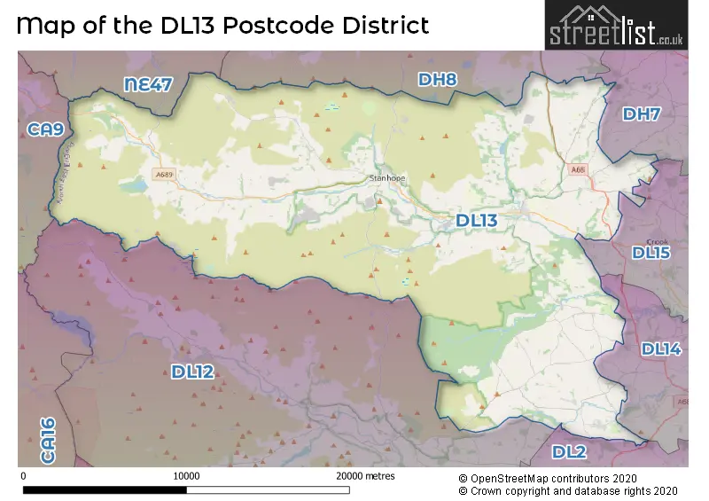
The DL13 Postcode shares a border with DH8 (CONSETT, Blackhill, Leadgate), DL14 (BISHOP AUCKLAND, St. Helen Auckland, West Auckland), DL15 (CROOK, Willington, Howden Le Wear), CA9 (ALSTON, Garrigill, Nenthead), NE47 (Haydon Bridge, Allendale, Bardon Mill), DH7 (Sacriston, Brandon, Ushaw Moor), DL2 (Middleton St. George, DARLINGTON, Hurworth) and DL12 (BARNARD CASTLE, Middleton-in-Teesdale, Eggleston).
In the DL13 postcode district, the primary settlement is Westgate, which is located in the county of Durham, England. Other significant settlements in this district include Stanhope, Wolsingham, and Bishop Auckland, all of which are also in Durham.
For the district DL13, we have data on 5 postcode sectors. Here's a breakdown: The sector DL13 1, covers Westgate and St. Johns Chapel and Wearhead and Ireshopeburn in Durham. The sector DL13 2, covers Stanhope and Frosterley and Rookhope in Durham. The sector DL13 3, covers Wolsingham and Hamsterley in Durham. The sector DL13 4, covers Tow Law and Satley in Durham. The sector DL13 5, covers Cockfield and Butterknowle and Woodland in Durham.


Map of the DL13 Postcode District
Explore the DL13 postcode district by using our free interactive map.
When it comes to local government, postal geography often disregards political borders. However, for a breakdown in the DL13 District: the district mostly encompasses the County Durham area with a total of 960 postcodes.
Weather Forecast for DL13
Press Button to Show Forecast for Stanhope
| Time Period | Icon | Description | Temperature | Rain Probability | Wind |
|---|---|---|---|---|---|
| 18:00 to 21:00 | Partly cloudy (day) | 7.0°C (feels like 4.0°C) | 1.00% | N 11 mph | |
| 21:00 to 00:00 | Cloudy | 3.0°C (feels like 2.0°C) | 3.00% | NW 4 mph |
Press Button to Show Forecast for Stanhope
| Time Period | Icon | Description | Temperature | Rain Probability | Wind |
|---|---|---|---|---|---|
| 00:00 to 03:00 | Cloudy | 3.0°C (feels like 1.0°C) | 4.00% | WNW 4 mph | |
| 03:00 to 06:00 | Cloudy | 3.0°C (feels like 0.0°C) | 4.00% | WNW 4 mph | |
| 06:00 to 09:00 | Overcast | 3.0°C (feels like 1.0°C) | 8.00% | WNW 4 mph | |
| 09:00 to 12:00 | Overcast | 6.0°C (feels like 4.0°C) | 8.00% | NNW 7 mph | |
| 12:00 to 15:00 | Overcast | 8.0°C (feels like 6.0°C) | 9.00% | N 7 mph | |
| 15:00 to 18:00 | Cloudy | 8.0°C (feels like 7.0°C) | 8.00% | N 7 mph | |
| 18:00 to 21:00 | Cloudy | 7.0°C (feels like 6.0°C) | 5.00% | ENE 4 mph | |
| 21:00 to 00:00 | Overcast | 5.0°C (feels like 4.0°C) | 9.00% | ESE 2 mph |
Press Button to Show Forecast for Stanhope
| Time Period | Icon | Description | Temperature | Rain Probability | Wind |
|---|---|---|---|---|---|
| 00:00 to 03:00 | Overcast | 4.0°C (feels like 3.0°C) | 10.00% | WSW 2 mph | |
| 03:00 to 06:00 | Overcast | 4.0°C (feels like 3.0°C) | 23.00% | N 2 mph | |
| 06:00 to 09:00 | Light rain | 4.0°C (feels like 2.0°C) | 52.00% | ENE 4 mph | |
| 09:00 to 12:00 | Cloudy | 6.0°C (feels like 5.0°C) | 15.00% | NE 4 mph | |
| 12:00 to 15:00 | Overcast | 7.0°C (feels like 6.0°C) | 16.00% | ENE 7 mph | |
| 15:00 to 18:00 | Overcast | 8.0°C (feels like 6.0°C) | 14.00% | ENE 7 mph | |
| 18:00 to 21:00 | Overcast | 7.0°C (feels like 5.0°C) | 13.00% | E 4 mph | |
| 21:00 to 00:00 | Cloudy | 5.0°C (feels like 4.0°C) | 10.00% | SE 2 mph |
Press Button to Show Forecast for Stanhope
| Time Period | Icon | Description | Temperature | Rain Probability | Wind |
|---|---|---|---|---|---|
| 00:00 to 03:00 | Overcast | 5.0°C (feels like 3.0°C) | 12.00% | SSW 2 mph | |
| 03:00 to 06:00 | Overcast | 5.0°C (feels like 4.0°C) | 16.00% | SSW 2 mph | |
| 06:00 to 09:00 | Light rain | 6.0°C (feels like 4.0°C) | 43.00% | WSW 4 mph | |
| 09:00 to 12:00 | Light rain | 8.0°C (feels like 6.0°C) | 44.00% | N 7 mph | |
| 12:00 to 15:00 | Light rain | 9.0°C (feels like 8.0°C) | 47.00% | NE 7 mph | |
| 15:00 to 18:00 | Light rain | 9.0°C (feels like 7.0°C) | 45.00% | NE 7 mph | |
| 18:00 to 21:00 | Overcast | 9.0°C (feels like 7.0°C) | 17.00% | NE 4 mph | |
| 21:00 to 00:00 | Overcast | 7.0°C (feels like 5.0°C) | 15.00% | N 4 mph |
Press Button to Show Forecast for Stanhope
| Time Period | Icon | Description | Temperature | Rain Probability | Wind |
|---|---|---|---|---|---|
| 00:00 to 03:00 | Overcast | 6.0°C (feels like 4.0°C) | 14.00% | NNW 7 mph | |
| 03:00 to 06:00 | Cloudy | 5.0°C (feels like 3.0°C) | 9.00% | NNW 7 mph | |
| 06:00 to 09:00 | Cloudy | 5.0°C (feels like 3.0°C) | 8.00% | NNW 7 mph | |
| 09:00 to 12:00 | Overcast | 7.0°C (feels like 4.0°C) | 9.00% | N 11 mph | |
| 12:00 to 15:00 | Overcast | 8.0°C (feels like 6.0°C) | 13.00% | NNE 11 mph | |
| 15:00 to 18:00 | Partly cloudy (day) | 9.0°C (feels like 6.0°C) | 10.00% | NNE 11 mph | |
| 18:00 to 21:00 | Sunny day | 8.0°C (feels like 5.0°C) | 2.00% | NNE 9 mph | |
| 21:00 to 00:00 | Clear night | 4.0°C (feels like 2.0°C) | 2.00% | N 7 mph |
Where is the DL13 Postcode District?
The DL13 postcode district is located in the town of Bishop Auckland. It is situated in the North East region. Nearby towns include Consett, which is approximately 10.6 miles away to the North East, Crook, which is about 11.1 miles away to the East, and Barnard Castle, which is around 13.4 miles away to the South. Riding Mill is also nearby, at a distance of about 14.3 miles to the North. Additionally, Shildon is situated approximately 15.8 miles away to the South East. The postcode district is located approximately 235.8 miles away from the center of London.
The district is within the post town of BISHOP AUCKLAND.
The sector has postcodes within the nation of England.
The DL13 Postcode District is in the Durham CC region of Tees Valley and Durham within the North East (England).
| Postcode Sector | Delivery Office |
|---|---|
| DL13 1 | Wear Valley Delivery Office |
| DL13 2 | Wear Valley Delivery Office |
| DL13 3 | Wear Valley Delivery Office |
| DL13 4 | Wear Valley Delivery Office |
| DL13 5 | Wear Valley Delivery Office |
| D | L | 1 | 3 | - | X | X | X |
| D | L | 1 | 3 | Space | Numeric | Letter | Letter |
Tourist Attractions within the Postcode Area
We found 2 visitor attractions within the DL13 postcode area
| Weardale Railway |
|---|
| Railways |
| Steam / Heritage Railway |
| View Weardale Railway on Google Maps |
| Hamsterley Forest |
| Country Parks |
| Country Park |
| View Hamsterley Forest on Google Maps |
Current Monthly Rental Prices
| # Bedrooms | Min Price | Max Price | Avg Price |
|---|---|---|---|
| 2 | £525 | £1,250 | £888 |
| 3 | £650 | £900 | £775 |
| 4 | £1,100 | £1,100 | £1,100 |
| 5 | £2,200 | £2,200 | £2,200 |
Current House Prices
| # Bedrooms | Min Price | Max Price | Avg Price |
|---|---|---|---|
| £20,000 | £1,000,000 | £183,330 | |
| 1 | £32,500 | £95,000 | £68,113 |
| 2 | £19,950 | £375,000 | £128,345 |
| 3 | £64,750 | £750,000 | £257,065 |
| 4 | £90,000 | £599,950 | £364,308 |
| 5 | £350,000 | £950,000 | £531,990 |
| 6 | £650,000 | £950,000 | £765,000 |
| 7 | £1,500,000 | £1,500,000 | £1,500,000 |
| 8 | £750,000 | £750,000 | £750,000 |
| 9 | £430,000 | £430,000 | £430,000 |
Estate Agents who Operate in the DL13 District
| Logo | Name | Brand Name | Address | Contact Number | Total Properties |
|---|---|---|---|---|---|
 | Crook | Robinsons | Royal Corner Crook DL15 9UA | 01388 311065 | 33 |
 | Crook | Venture Properties | 5 South Street Crook DL15 8NE | 01380 713783 | 15 |
 | Barnard Castle | George F.White | 14c Redwell Court, Barnard Castle, County Durham DL12 8BN | 03339 202220 | 10 |
 | Bishop Auckland | Hunters | 147-149 Newgate Street, Bishop Auckland, County Durham, DL14 7EN | 01388 311394 | 9 |
 | Barnard Castle | GSC Grays | 12 The Bank, Barnard Castle, DL12 8PQ | 01833 600890 | 8 |
- Burtree Ford
- Butterknowle
- Cockfield
- Copley
- Crawleyside
- Crook
- Daddry Shield
- East Butsfield
- East Hedleyhope
- Eastgate
- Evenwood
- Frosterley
- Hamsterley
- Inkerman
- Ireshopeburn
- Lanehead
- Morley
- Rookhope
- Rowley
- Satley
- South Side
- St John's Chapel
- Stanhope
- Sunniside
- Thornley
- Tow Law
- Wearhead
- Westgate
- Witton-le-Wear
- Wolsingham
- Woodland
| Type of Property | 2018 Average | 2018 Sales | 2017 Average | 2017 Sales | 2016 Average | 2016 Sales | 2015 Average | 2015 Sales |
|---|---|---|---|---|---|---|---|---|
| Detached | £253,343 | 45 | £254,119 | 54 | £252,899 | 56 | £211,008 | 58 |
| Semi-Detached | £138,914 | 35 | £165,140 | 34 | £122,906 | 35 | £119,424 | 44 |
| Terraced | £106,073 | 114 | £101,450 | 123 | £90,244 | 118 | £89,538 | 122 |
| Flats | £142,500 | 3 | £125,538 | 8 | £76,571 | 7 | £72,290 | 5 |
Hotels within the Postcode Area
We found 29 hotels and guest houses within the DL13 postcode area
Coves Bunk House
Coves House, Wolsingham, Weardale, Bishop Aucklan, wolsingham, DL13 3BG.
View detailsStanhope Old Hall Bed and Breakfast
Front Street, Stanhope, Bishop Auckland, Stanhope, stanhope, DL13 2PF.
View detailsNewlands Hall
Newlands Hall, Frosterley, Bishop Auckland, County Durham, Bishop Auckland, frosterley, DL13 2SH.
View detailsPasture Gate Cottage Bed & Breakfast
High Doctor Pasture, Bishop Auckland, County Durham, Wolsingham, wolsingham, DL13 3LR.
View detailsOld Coach House At The Golden Lion
12 Market Place, St John's Chapel, Weardale, Saint Johns Chapel, saint-johns-chapel, DL13 1QF.
View detailsJoined-Up Holidays
The Stables,Paradise Farm, Woodland, Bishop Auckland, Co Durham, Bishop Auckland, hamsterley, DL13 5RH.
View details