The DL13 2 postcode sector stands on the Durham and Northumberland border.
Did you know? According to the 2021 Census, the DL13 2 postcode sector is home to a bustling 2,981 residents!
Given that each sector allows for 400 unique postcode combinations. Letters C, I, K, M, O and V are not allowed in the last two letters of a postcode. With 256 postcodes already in use, this leaves 144 units available.
The largest settlement in the DL13 2 postal code is Stanhope followed by Frosterley, and Rookhope.
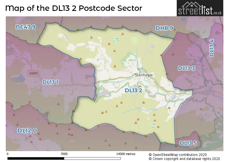
The DL13 2 Postcode shares a border with NE47 9 (Allendale, Catton, Allenheads), DH8 9 (CONSETT, Blanchland, Castleside), DL12 0 (Middleton-in-Teesdale, Eggleston, Mickleton), DL13 1 (Westgate, St. Johns Chapel, Wearhead), DL13 3 (Wolsingham, Hamsterley) and DL13 5 (Cockfield, Butterknowle, Woodland).
The sector is within the post town of BISHOP AUCKLAND.
DL13 2 is a postcode sector within the DL13 postcode district which is within the DL Darlington postcode area.
The Royal Mail delivery office for the DL13 2 postal sector is the Wear Valley Delivery Office.
The area of the DL13 2 postcode sector is 59.97 square miles which is 155.32 square kilometres or 38,380.98 square acres.
Waterways within the DL13 2 postcode sector include the Wear, River Wear, Ballihope Burn, Fine Burn, Howden Burn, Black Burn, Cow Burn.

Map of the DL13 2 Postcode Sector
Explore the DL13 2 postcode sector by using our free interactive map.
| D | L | 1 | 3 | - | 2 | X | X |
| D | L | 1 | 3 | Space | 2 | Letter | Letter |
Official List of Streets
Stanhope (54 Streets)
Frosterley (31 Streets)
Rookhope (9 Streets)
Eastgate (2 Streets)
Unofficial Streets or Alternative Spellings
Weather Forecast for DL13 2
Press Button to Show Forecast for Stanhope
| Time Period | Icon | Description | Temperature | Rain Probability | Wind |
|---|---|---|---|---|---|
| 00:00 to 03:00 | Cloudy | 3.0°C (feels like 1.0°C) | 4.00% | WNW 4 mph | |
| 03:00 to 06:00 | Cloudy | 3.0°C (feels like 0.0°C) | 4.00% | WNW 4 mph | |
| 06:00 to 09:00 | Overcast | 3.0°C (feels like 1.0°C) | 8.00% | WNW 4 mph | |
| 09:00 to 12:00 | Overcast | 6.0°C (feels like 4.0°C) | 8.00% | NNW 7 mph | |
| 12:00 to 15:00 | Overcast | 8.0°C (feels like 6.0°C) | 9.00% | N 7 mph | |
| 15:00 to 18:00 | Cloudy | 8.0°C (feels like 7.0°C) | 8.00% | N 7 mph | |
| 18:00 to 21:00 | Cloudy | 7.0°C (feels like 6.0°C) | 5.00% | ENE 4 mph | |
| 21:00 to 00:00 | Overcast | 5.0°C (feels like 4.0°C) | 9.00% | ESE 2 mph |
Press Button to Show Forecast for Stanhope
| Time Period | Icon | Description | Temperature | Rain Probability | Wind |
|---|---|---|---|---|---|
| 00:00 to 03:00 | Overcast | 4.0°C (feels like 3.0°C) | 10.00% | WSW 2 mph | |
| 03:00 to 06:00 | Overcast | 4.0°C (feels like 3.0°C) | 23.00% | N 2 mph | |
| 06:00 to 09:00 | Light rain | 4.0°C (feels like 2.0°C) | 52.00% | ENE 4 mph | |
| 09:00 to 12:00 | Cloudy | 6.0°C (feels like 5.0°C) | 15.00% | NE 4 mph | |
| 12:00 to 15:00 | Overcast | 7.0°C (feels like 6.0°C) | 16.00% | ENE 7 mph | |
| 15:00 to 18:00 | Overcast | 8.0°C (feels like 6.0°C) | 14.00% | ENE 7 mph | |
| 18:00 to 21:00 | Overcast | 7.0°C (feels like 5.0°C) | 13.00% | E 4 mph | |
| 21:00 to 00:00 | Cloudy | 5.0°C (feels like 4.0°C) | 10.00% | SE 2 mph |
Press Button to Show Forecast for Stanhope
| Time Period | Icon | Description | Temperature | Rain Probability | Wind |
|---|---|---|---|---|---|
| 00:00 to 03:00 | Overcast | 5.0°C (feels like 3.0°C) | 12.00% | SSW 2 mph | |
| 03:00 to 06:00 | Overcast | 5.0°C (feels like 4.0°C) | 16.00% | SSW 2 mph | |
| 06:00 to 09:00 | Light rain | 6.0°C (feels like 4.0°C) | 43.00% | WSW 4 mph | |
| 09:00 to 12:00 | Light rain | 8.0°C (feels like 6.0°C) | 44.00% | N 7 mph | |
| 12:00 to 15:00 | Light rain | 9.0°C (feels like 8.0°C) | 47.00% | NE 7 mph | |
| 15:00 to 18:00 | Light rain | 9.0°C (feels like 7.0°C) | 45.00% | NE 7 mph | |
| 18:00 to 21:00 | Overcast | 9.0°C (feels like 7.0°C) | 17.00% | NE 4 mph | |
| 21:00 to 00:00 | Overcast | 7.0°C (feels like 5.0°C) | 15.00% | N 4 mph |
Press Button to Show Forecast for Stanhope
| Time Period | Icon | Description | Temperature | Rain Probability | Wind |
|---|---|---|---|---|---|
| 00:00 to 03:00 | Overcast | 6.0°C (feels like 4.0°C) | 14.00% | NNW 7 mph | |
| 03:00 to 06:00 | Cloudy | 5.0°C (feels like 3.0°C) | 9.00% | NNW 7 mph | |
| 06:00 to 09:00 | Cloudy | 5.0°C (feels like 3.0°C) | 8.00% | NNW 7 mph | |
| 09:00 to 12:00 | Overcast | 7.0°C (feels like 4.0°C) | 9.00% | N 11 mph | |
| 12:00 to 15:00 | Overcast | 8.0°C (feels like 6.0°C) | 13.00% | NNE 11 mph | |
| 15:00 to 18:00 | Partly cloudy (day) | 9.0°C (feels like 6.0°C) | 10.00% | NNE 11 mph | |
| 18:00 to 21:00 | Sunny day | 8.0°C (feels like 5.0°C) | 2.00% | NNE 9 mph | |
| 21:00 to 00:00 | Clear night | 4.0°C (feels like 2.0°C) | 2.00% | N 7 mph |
Schools and Places of Education Within the DL13 2 Postcode Sector
Frosterley Primary School
Community school
Bridge End, Bishop Auckland, County Durham, DL13 2SN
Head: Mrs Mary Clare Carr
Ofsted Rating: Good
Inspection: 2022-09-21 (577 days ago)
Website: Visit Frosterley Primary School Website
Phone: 01388528358
Number of Pupils: 39
Rookhope Primary School
Community school
Rookhope, Bishop Auckland, County Durham, DL13 2DA
Head: Mrs Sarah Hodgkinson
Ofsted Rating: Good
Inspection: 2017-09-26 (2398 days ago)
Website: Visit Rookhope Primary School Website
Phone: 01388517268
Number of Pupils: 9
House Prices in the DL13 2 Postcode Sector
| Type of Property | 2018 Average | 2018 Sales | 2017 Average | 2017 Sales | 2016 Average | 2016 Sales | 2015 Average | 2015 Sales |
|---|---|---|---|---|---|---|---|---|
| Detached | £279,643 | 14 | £231,375 | 8 | £258,500 | 4 | £219,177 | 11 |
| Semi-Detached | £118,483 | 6 | £194,750 | 4 | £120,545 | 10 | £117,750 | 4 |
| Terraced | £143,133 | 24 | £110,483 | 29 | £106,160 | 25 | £101,574 | 27 |
| Flats | £165,000 | 1 | £132,966 | 4 | £106,250 | 4 | £0 | 0 |
Important Postcodes DL13 2 in the Postcode Sector
DL13 2DA is the postcode for Rookhope Primary School, Rookhope
DL13 2FJ is the postcode for Durham Dales Centre, Castle Gardens
DL13 2JR is the postcode for Weardale Community Hospital, Stanhope
DL13 2NU is the postcode for STANHOPE BARRINGTON CHURCH OF ENGLAND PRIMARY SCHOOL, WESTCROFT, DURHAM, and Stanhope Barrington C of E School, Westcroft
DL13 2PG is the postcode for Newtown House, Stanhope
DL13 2SN is the postcode for Frosterley Community Primary School, Bridge End
DL13 2XD is the postcode for Stanhope Health Centre, Dales Street
| The DL13 2 Sector is within these Local Authorities |
|
|---|---|
| The DL13 2 Sector is within these Counties |
|
| The DL13 2 Sector is within these Water Company Areas |
|
Tourist Attractions within the DL13 2 Postcode Area
We found 1 visitor attractions within the DL13 postcode area
| Weardale Railway |
|---|
| Railways |
| Steam / Heritage Railway |
| View Weardale Railway on Google Maps |