The DL15 9 postcode sector is within the county of Durham.
Did you know? According to the 2021 Census, the DL15 9 postcode sector is home to a bustling 8,808 residents!
Given that each sector allows for 400 unique postcode combinations. Letters C, I, K, M, O and V are not allowed in the last two letters of a postcode. With 256 postcodes already in use, this leaves 144 units available.
The largest settlement in the DL15 9 postal code is CROOK followed by Stanley, and Billy Row.
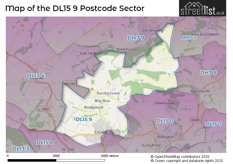
The DL15 9 Postcode shares a border with DL13 4 (Tow Law, Sunniside, Satley), DH7 7 (Ushaw Moor, Bearpark, New Brancepeth), DH7 8 (Brandon, Langley Moor, Meadowfield), DH7 9 (Langley Park, Esh Winning, Waterhouses), DL15 0 (Willington, Hunwick, Sunnybrow) and DL15 8 (CROOK, Howden Le Wear, Fir Tree).
The sector is within the post town of CROOK.
DL15 9 is a postcode sector within the DL15 postcode district which is within the DL Darlington postcode area.
The Royal Mail delivery office for the DL15 9 postal sector is the Wear Valley Delivery Office.
The area of the DL15 9 postcode sector is 10.03 square miles which is 25.98 square kilometres or 6,419.55 square acres.
Waterways within the DL15 9 postcode sector include the Beechburn Beck, River Deerness.

Map of the DL15 9 Postcode Sector
Explore the DL15 9 postcode sector by using our free interactive map.
| D | L | 1 | 5 | - | 9 | X | X |
| D | L | 1 | 5 | Space | 9 | Letter | Letter |
Official List of Streets
CROOK (140 Streets)
Billy Row (15 Streets)
Stanley (19 Streets)
Unofficial Streets or Alternative Spellings
Helmington Row
FRONT STREETCROOK
DALE VIEW DAWSON STREET ELLIOTT STREET ENNERDALE DRIVE ORCHARD CLOSE PROSPECT ROAD SOUTH STREETWillington
NORTH LANETow Law
RODDYMOOR ROADBrancepeth
WOLSINGHAM ROADSunniside
FRONT STREETWeather Forecast for DL15 9
Press Button to Show Forecast for Crook
| Time Period | Icon | Description | Temperature | Rain Probability | Wind |
|---|---|---|---|---|---|
| 15:00 to 18:00 | Cloudy | 6.0°C (feels like 4.0°C) | 12.00% | NNE 9 mph | |
| 18:00 to 21:00 | Partly cloudy (day) | 6.0°C (feels like 3.0°C) | 6.00% | NNE 9 mph | |
| 21:00 to 00:00 | Partly cloudy (night) | 2.0°C (feels like 0.0°C) | 0.00% | NNE 4 mph |
Press Button to Show Forecast for Crook
| Time Period | Icon | Description | Temperature | Rain Probability | Wind |
|---|---|---|---|---|---|
| 00:00 to 03:00 | Cloudy | 2.0°C (feels like 0.0°C) | 4.00% | NNW 4 mph | |
| 03:00 to 06:00 | Cloudy | 1.0°C (feels like -1.0°C) | 5.00% | NW 4 mph | |
| 06:00 to 09:00 | Overcast | 3.0°C (feels like 0.0°C) | 8.00% | NNW 4 mph | |
| 09:00 to 12:00 | Light rain shower (day) | 6.0°C (feels like 4.0°C) | 29.00% | NNE 7 mph | |
| 12:00 to 15:00 | Overcast | 7.0°C (feels like 5.0°C) | 12.00% | ENE 4 mph | |
| 15:00 to 18:00 | Overcast | 7.0°C (feels like 5.0°C) | 12.00% | ENE 7 mph | |
| 18:00 to 21:00 | Partly cloudy (day) | 6.0°C (feels like 4.0°C) | 3.00% | E 7 mph | |
| 21:00 to 00:00 | Partly cloudy (night) | 3.0°C (feels like 1.0°C) | 2.00% | E 4 mph |
Press Button to Show Forecast for Crook
| Time Period | Icon | Description | Temperature | Rain Probability | Wind |
|---|---|---|---|---|---|
| 00:00 to 03:00 | Partly cloudy (night) | 1.0°C (feels like 0.0°C) | 3.00% | ESE 2 mph | |
| 03:00 to 06:00 | Partly cloudy (night) | 1.0°C (feels like -1.0°C) | 4.00% | ENE 4 mph | |
| 06:00 to 09:00 | Partly cloudy (day) | 3.0°C (feels like 2.0°C) | 5.00% | E 4 mph | |
| 09:00 to 12:00 | Cloudy | 7.0°C (feels like 5.0°C) | 11.00% | E 7 mph | |
| 12:00 to 15:00 | Overcast | 8.0°C (feels like 6.0°C) | 14.00% | E 9 mph | |
| 15:00 to 18:00 | Overcast | 9.0°C (feels like 6.0°C) | 18.00% | E 9 mph | |
| 18:00 to 21:00 | Cloudy | 7.0°C (feels like 5.0°C) | 14.00% | ENE 9 mph | |
| 21:00 to 00:00 | Cloudy | 5.0°C (feels like 3.0°C) | 14.00% | ENE 7 mph |
Press Button to Show Forecast for Crook
| Time Period | Icon | Description | Temperature | Rain Probability | Wind |
|---|---|---|---|---|---|
| 00:00 to 03:00 | Cloudy | 4.0°C (feels like 2.0°C) | 16.00% | NE 7 mph | |
| 03:00 to 06:00 | Light rain | 5.0°C (feels like 2.0°C) | 47.00% | NNE 9 mph | |
| 06:00 to 09:00 | Heavy rain | 6.0°C (feels like 3.0°C) | 68.00% | NNE 9 mph | |
| 09:00 to 12:00 | Heavy rain | 8.0°C (feels like 5.0°C) | 72.00% | NE 11 mph | |
| 12:00 to 15:00 | Light rain | 9.0°C (feels like 6.0°C) | 50.00% | NNE 11 mph | |
| 15:00 to 18:00 | Heavy rain | 9.0°C (feels like 7.0°C) | 76.00% | NNE 9 mph | |
| 18:00 to 21:00 | Heavy rain shower (day) | 9.0°C (feels like 7.0°C) | 56.00% | NNE 9 mph | |
| 21:00 to 00:00 | Clear night | 6.0°C (feels like 4.0°C) | 11.00% | ENE 7 mph |
Schools and Places of Education Within the DL15 9 Postcode Sector
Hartside Primary Academy
Academy converter
Hartside, Crook, County Durham, DL15 9NN
Head: Mr Shawn Laws
Ofsted Rating: Good
Inspection: 2022-06-15 (680 days ago)
Website: Visit Hartside Primary Academy Website
Phone: 01388766686
Number of Pupils: 218
Stanley (Crook) Primary School
Community school
Wooley Terrace, Crook, County Durham, DL15 9AN
Head: Mr David Christie
Ofsted Rating: Good
Inspection: 2019-02-13 (1898 days ago)
Website: Visit Stanley (Crook) Primary School Website
Phone: 01388762858
Number of Pupils: 136
House Prices in the DL15 9 Postcode Sector
| Type of Property | 2018 Average | 2018 Sales | 2017 Average | 2017 Sales | 2016 Average | 2016 Sales | 2015 Average | 2015 Sales |
|---|---|---|---|---|---|---|---|---|
| Detached | £176,901 | 31 | £185,145 | 33 | £161,006 | 40 | £168,032 | 47 |
| Semi-Detached | £111,317 | 30 | £90,982 | 28 | £99,345 | 31 | £103,353 | 40 |
| Terraced | £68,353 | 80 | £67,310 | 93 | £65,745 | 82 | £69,249 | 85 |
| Flats | £28,000 | 1 | £35,300 | 5 | £42,439 | 5 | £50,167 | 3 |
Important Postcodes DL15 9 in the Postcode Sector
DL15 9AN is the postcode for Stanley Crook Primary School, Stanley
DL15 9DN is the postcode for ST CUTHBERTS RC PRIMARY SCHOOL, CHURCH HILL, and St. Cuthberts RC Primary School, Church Hill
DL15 9ES is the postcode for Durham County Council, Civic Centre, Durham County Council, Civic Centre, North Terrace, and Wear Valley District Council, Civic Centre, North Terrace
DL15 9GR is the postcode for Crook Community Fire Station, Peases Way
DL15 9HU is the postcode for Crook Health Centre, Hope Street
DL15 9NN is the postcode for Hartside Primary Academy, Hartside Primary School, Hartside, and Hartside Primary School, Hartside
DL15 9SZ is the postcode for Peases West Primary School, Billy Row
| The DL15 9 Sector is within these Local Authorities |
|
|---|---|
| The DL15 9 Sector is within these Counties |
|
| The DL15 9 Sector is within these Water Company Areas |
|