The DL4 postcode district is a postal district located in the DL Darlington postcode area with a population of 10,100 residents according to the 2021 England and Wales Census.
The area of the DL4 postcode district is 7.13 square miles which is 18.47 square kilometres or 4,564.76 acres.
Currently, the DL4 district has about 300 postcode units spread across 2 geographic postcode sectors.
Given that each sector allows for 400 unique postcode combinations, the district has a capacity of 800 postcodes. With 300 postcodes already in use, this leaves 500 units available.
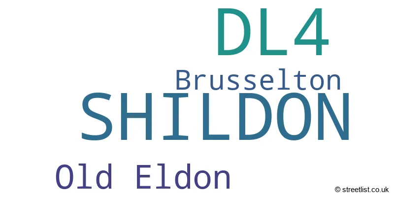
The DL4 postal code covers the settlement of SHILDON.
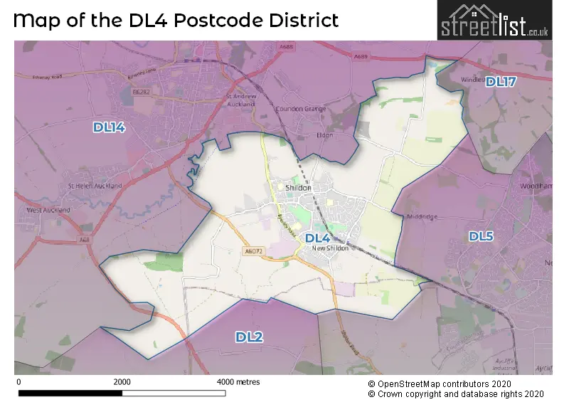
The DL4 Postcode shares a border with DL14 (BISHOP AUCKLAND, St. Helen Auckland, West Auckland), DL2 (Middleton St. George, DARLINGTON, Hurworth) and DL5 (NEWTON AYCLIFFE, Aycliffe Business Park, Heighington Village).
The primary settlement in the DL4 postcode district is Shildon, located in the county of Durham. There is another significant settlement called Brusselton in the same district. The post town for DL4 is Shildon, also in Durham county.
For the district DL4, we have data on 2 postcode sectors. Here's a breakdown: The sector DL4 1, covers Shildon in Durham. The sector DL4 2, covers Shildon in Durham.

Map of the DL4 Postcode District
Explore the DL4 postcode district by using our free interactive map.
When it comes to local government, postal geography often disregards political borders. However, for a breakdown in the DL4 District: the district mostly encompasses the County Durham area with a total of 301 postcodes.
Weather Forecast for DL4
Press Button to Show Forecast for Shildon
| Time Period | Icon | Description | Temperature | Rain Probability | Wind |
|---|---|---|---|---|---|
| 15:00 to 18:00 | Cloudy | 8.0°C (feels like 5.0°C) | 4.00% | NNE 9 mph | |
| 18:00 to 21:00 | Cloudy | 6.0°C (feels like 4.0°C) | 4.00% | E 7 mph | |
| 21:00 to 00:00 | Cloudy | 5.0°C (feels like 3.0°C) | 5.00% | S 7 mph |
Press Button to Show Forecast for Shildon
| Time Period | Icon | Description | Temperature | Rain Probability | Wind |
|---|---|---|---|---|---|
| 00:00 to 03:00 | Cloudy | 5.0°C (feels like 3.0°C) | 7.00% | SW 7 mph | |
| 03:00 to 06:00 | Cloudy | 5.0°C (feels like 2.0°C) | 4.00% | NW 9 mph | |
| 06:00 to 09:00 | Cloudy | 4.0°C (feels like 1.0°C) | 4.00% | NNW 7 mph | |
| 09:00 to 12:00 | Cloudy | 5.0°C (feels like 2.0°C) | 6.00% | N 13 mph | |
| 12:00 to 15:00 | Cloudy | 6.0°C (feels like 3.0°C) | 8.00% | NNE 13 mph | |
| 15:00 to 18:00 | Cloudy | 6.0°C (feels like 2.0°C) | 9.00% | NNE 11 mph | |
| 18:00 to 21:00 | Partly cloudy (day) | 6.0°C (feels like 3.0°C) | 1.00% | NNE 9 mph | |
| 21:00 to 00:00 | Partly cloudy (night) | 3.0°C (feels like 1.0°C) | 1.00% | N 4 mph |
Press Button to Show Forecast for Shildon
| Time Period | Icon | Description | Temperature | Rain Probability | Wind |
|---|---|---|---|---|---|
| 00:00 to 03:00 | Cloudy | 2.0°C (feels like 0.0°C) | 4.00% | NW 4 mph | |
| 03:00 to 06:00 | Cloudy | 2.0°C (feels like 0.0°C) | 5.00% | NW 4 mph | |
| 06:00 to 09:00 | Overcast | 3.0°C (feels like 1.0°C) | 9.00% | NNW 4 mph | |
| 09:00 to 12:00 | Cloudy | 5.0°C (feels like 3.0°C) | 8.00% | NNE 4 mph | |
| 12:00 to 15:00 | Overcast | 7.0°C (feels like 5.0°C) | 11.00% | ENE 7 mph | |
| 15:00 to 18:00 | Cloudy | 7.0°C (feels like 5.0°C) | 8.00% | ENE 7 mph | |
| 18:00 to 21:00 | Partly cloudy (day) | 7.0°C (feels like 5.0°C) | 4.00% | E 7 mph | |
| 21:00 to 00:00 | Partly cloudy (night) | 3.0°C (feels like 1.0°C) | 2.00% | E 4 mph |
Press Button to Show Forecast for Shildon
| Time Period | Icon | Description | Temperature | Rain Probability | Wind |
|---|---|---|---|---|---|
| 00:00 to 03:00 | Partly cloudy (night) | 2.0°C (feels like 0.0°C) | 3.00% | SE 2 mph | |
| 03:00 to 06:00 | Partly cloudy (night) | 1.0°C (feels like 0.0°C) | 4.00% | ENE 4 mph | |
| 06:00 to 09:00 | Partly cloudy (day) | 3.0°C (feels like 2.0°C) | 5.00% | E 4 mph | |
| 09:00 to 12:00 | Partly cloudy (day) | 7.0°C (feels like 5.0°C) | 9.00% | E 7 mph | |
| 12:00 to 15:00 | Overcast | 8.0°C (feels like 6.0°C) | 18.00% | ENE 9 mph | |
| 15:00 to 18:00 | Overcast | 8.0°C (feels like 6.0°C) | 14.00% | E 9 mph | |
| 18:00 to 21:00 | Cloudy | 7.0°C (feels like 5.0°C) | 12.00% | ENE 9 mph | |
| 21:00 to 00:00 | Cloudy | 5.0°C (feels like 3.0°C) | 15.00% | ENE 7 mph |
Press Button to Show Forecast for Shildon
| Time Period | Icon | Description | Temperature | Rain Probability | Wind |
|---|---|---|---|---|---|
| 00:00 to 03:00 | Cloudy | 5.0°C (feels like 2.0°C) | 16.00% | NE 7 mph | |
| 03:00 to 06:00 | Cloudy | 5.0°C (feels like 2.0°C) | 18.00% | NE 9 mph | |
| 06:00 to 09:00 | Light rain | 6.0°C (feels like 3.0°C) | 49.00% | NNE 9 mph | |
| 09:00 to 12:00 | Heavy rain | 7.0°C (feels like 4.0°C) | 72.00% | NE 11 mph | |
| 12:00 to 15:00 | Heavy rain | 9.0°C (feels like 7.0°C) | 73.00% | NE 11 mph | |
| 15:00 to 18:00 | Heavy rain | 9.0°C (feels like 7.0°C) | 76.00% | NNE 11 mph | |
| 18:00 to 21:00 | Heavy rain shower (day) | 9.0°C (feels like 7.0°C) | 55.00% | NNE 9 mph | |
| 21:00 to 00:00 | Partly cloudy (night) | 6.0°C (feels like 4.0°C) | 11.00% | ENE 7 mph |
Where is the DL4 Postcode District?
The postcode district for DL4 is located in Shildon. Shildon is a district town that is surrounded by several nearby towns. In the northwest direction, you will find Bishop Auckland which is approximately 1.86 miles away. Towards the east, Newton Aycliffe is located at a distance of approximately 2.82 miles. Spenymoor can be found in the northeast direction and it is approximately 5.10 miles away. Moving southeast, you will reach Darlington which is about 8.80 miles away. Going north, you will come across Durham which is around 10.70 miles away. Finally, in the southwest direction, Barnard Castle is located at a distance of approximately 12.25 miles. Additionally, the postcode district is approximately 224.91 miles away from the center of London.
The district is within the post town of SHILDON.
The sector has postcodes within the nation of England.
The DL4 Postcode District is covers the following regions.
- Durham CC - Tees Valley and Durham - North East (England)
- Darlington - Tees Valley and Durham - North East (England)
| Postcode Sector | Delivery Office |
|---|---|
| DL4 1 | Wear Valley Delivery Office |
| DL4 2 | Wear Valley Delivery Office |
| D | L | 4 | - | X | X | X |
| D | L | 4 | Space | Numeric | Letter | Letter |
Tourist Attractions within the Postcode Area
We found 1 visitor attractions within the DL4 postcode area
| Locomotion The National Railway Museum at Shildon |
|---|
| Museums & Art Galleries |
| Museum and / or Art Gallery |
| View Locomotion The National Railway Museum at Shildon on Google Maps |
Current Monthly Rental Prices
| # Bedrooms | Min Price | Max Price | Avg Price |
|---|---|---|---|
| 2 | £475 | £550 | £506 |
| 3 | £595 | £595 | £595 |
Current House Prices
| # Bedrooms | Min Price | Max Price | Avg Price |
|---|---|---|---|
| £35,000 | £65,000 | £52,500 | |
| 1 | £10,000 | £80,000 | £45,000 |
| 2 | £35,000 | £134,950 | £62,662 |
| 3 | £35,000 | £240,000 | £104,056 |
| 4 | £180,000 | £430,000 | £272,985 |
Estate Agents who Operate in the DL4 District
| Logo | Name | Brand Name | Address | Contact Number | Total Properties |
|---|---|---|---|---|---|
 | Bishop Auckland | Hunters | 147-149 Newgate Street, Bishop Auckland, County Durham, DL14 7EN | 01388 311394 | 17 |
 | Bishop Auckland | Robinsons | 120, Newgate Street, Bishop Auckland, DL14 7EH | 01388 311499 | 15 |
 | Bishop Auckland | Dowen | 125 Newgate Street Bishop Auckland DL14 7EN | 01388 311730 | 14 |
 | Bishop Auckland | J W Wood | 128 Newgate Street, Bishop Auckland, DL14 7EH | 01388 311003 | 5 |
 | Bishop Auckland | Holbrook & Co | 121 Newgate Street, Bishop Auckland, DL14 7EN | 01388 311372 | 4 |
| Type of Property | 2018 Average | 2018 Sales | 2017 Average | 2017 Sales | 2016 Average | 2016 Sales | 2015 Average | 2015 Sales |
|---|---|---|---|---|---|---|---|---|
| Detached | £165,142 | 48 | £169,354 | 25 | £195,582 | 38 | £152,532 | 31 |
| Semi-Detached | £79,710 | 29 | £87,730 | 36 | £96,930 | 39 | £89,636 | 46 |
| Terraced | £52,124 | 124 | £54,780 | 115 | £50,196 | 120 | £54,414 | 127 |
| Flats | £1,943,852 | 1 | £38,000 | 1 | £35,125 | 4 | £28,750 | 2 |