The DN18 postcode district is a postal district located in the DN Doncaster postcode area with a population of 12,772 residents according to the 2021 England and Wales Census.
The area of the DN18 postcode district is 21.53 square miles which is 55.77 square kilometres or 13,779.87 acres.
Currently, the DN18 district has about 362 postcode units spread across 2 geographic postcode sectors.
Given that each sector allows for 400 unique postcode combinations, the district has a capacity of 800 postcodes. With 362 postcodes already in use, this leaves 438 units available.
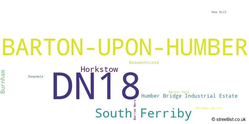
The largest settlement in the DN18 postal code is BARTON-UPON-HUMBER followed by South Ferriby, and Horkstow.
The postcode area has a boundary with The Humber.
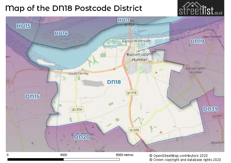
The DN18 Postcode shares a border with DN15 (SCUNTHORPE, Winterton, Burton-upon-Stather), DN19 (BARROW-UPON-HUMBER, Goxhill, New Holland), DN20 (BRIGG, Broughton, Hibaldstow) and DN39 (ULCEBY, Wootton, Kirmington).
The primary settlement in the DN18 postcode district is Barton-upon-Humber in Lincolnshire, England. The other significant settlements in this district include Hoe Hill, Humber Bridge Industrial Estate, Barrow Mere, Barton Vale, Beaumontcote, Burnham, Burnham Warren, Deepdale, Horkstow, and South Ferriby. The most significant post town in this district is Barton-upon-Humber.
For the district DN18, we have data on 3 postcode sectors. Here's a breakdown: The sector DN18 5, covers Barton-Upon-Humber in Lincolnshire. The sector DN18 6, covers Barton-Upon-Humber and South Ferriby in Lincolnshire. The sector DN18 9 is non-geographic. It's often designated for PO Boxes, large organisations, or special services.

Map of the DN18 Postcode District
Explore the DN18 postcode district by using our free interactive map.
When it comes to local government, postal geography often disregards political borders. However, for a breakdown in the DN18 District: the district mostly encompasses the North Lincolnshire (B) area with a total of 370 postcodes.
Weather Forecast for DN18
Press Button to Show Forecast for Barton-Upon-Humber
| Time Period | Icon | Description | Temperature | Rain Probability | Wind |
|---|---|---|---|---|---|
| 15:00 to 18:00 | Cloudy | 8.0°C (feels like 6.0°C) | 9.00% | NNE 11 mph | |
| 18:00 to 21:00 | Sunny day | 7.0°C (feels like 4.0°C) | 2.00% | NNE 11 mph | |
| 21:00 to 00:00 | Clear night | 4.0°C (feels like 1.0°C) | 1.00% | N 7 mph |
Press Button to Show Forecast for Barton-Upon-Humber
| Time Period | Icon | Description | Temperature | Rain Probability | Wind |
|---|---|---|---|---|---|
| 00:00 to 03:00 | Partly cloudy (night) | 2.0°C (feels like 0.0°C) | 2.00% | NNW 4 mph | |
| 03:00 to 06:00 | Cloudy | 2.0°C (feels like 0.0°C) | 8.00% | NW 4 mph | |
| 06:00 to 09:00 | Cloudy | 4.0°C (feels like 2.0°C) | 6.00% | N 4 mph | |
| 09:00 to 12:00 | Overcast | 7.0°C (feels like 6.0°C) | 9.00% | NE 4 mph | |
| 12:00 to 15:00 | Overcast | 8.0°C (feels like 7.0°C) | 13.00% | ENE 7 mph | |
| 15:00 to 18:00 | Overcast | 9.0°C (feels like 7.0°C) | 14.00% | ENE 7 mph | |
| 18:00 to 21:00 | Cloudy | 8.0°C (feels like 5.0°C) | 6.00% | E 7 mph | |
| 21:00 to 00:00 | Partly cloudy (night) | 5.0°C (feels like 3.0°C) | 2.00% | E 7 mph |
Press Button to Show Forecast for Barton-Upon-Humber
| Time Period | Icon | Description | Temperature | Rain Probability | Wind |
|---|---|---|---|---|---|
| 00:00 to 03:00 | Partly cloudy (night) | 4.0°C (feels like 1.0°C) | 4.00% | ENE 4 mph | |
| 03:00 to 06:00 | Partly cloudy (night) | 3.0°C (feels like 1.0°C) | 7.00% | ENE 7 mph | |
| 06:00 to 09:00 | Partly cloudy (day) | 5.0°C (feels like 3.0°C) | 7.00% | ENE 7 mph | |
| 09:00 to 12:00 | Cloudy | 9.0°C (feels like 6.0°C) | 11.00% | ENE 9 mph | |
| 12:00 to 15:00 | Cloudy | 9.0°C (feels like 7.0°C) | 18.00% | E 11 mph | |
| 15:00 to 18:00 | Cloudy | 10.0°C (feels like 7.0°C) | 16.00% | ENE 11 mph | |
| 18:00 to 21:00 | Cloudy | 9.0°C (feels like 6.0°C) | 13.00% | ENE 11 mph | |
| 21:00 to 00:00 | Cloudy | 8.0°C (feels like 5.0°C) | 12.00% | ENE 11 mph |
Press Button to Show Forecast for Barton-Upon-Humber
| Time Period | Icon | Description | Temperature | Rain Probability | Wind |
|---|---|---|---|---|---|
| 00:00 to 03:00 | Overcast | 7.0°C (feels like 4.0°C) | 22.00% | NE 11 mph | |
| 03:00 to 06:00 | Light rain | 8.0°C (feels like 4.0°C) | 51.00% | NE 13 mph | |
| 06:00 to 09:00 | Heavy rain | 8.0°C (feels like 5.0°C) | 76.00% | NE 13 mph | |
| 09:00 to 12:00 | Light rain | 10.0°C (feels like 7.0°C) | 58.00% | E 13 mph | |
| 12:00 to 15:00 | Light rain shower (day) | 11.0°C (feels like 8.0°C) | 42.00% | E 13 mph | |
| 15:00 to 18:00 | Light rain shower (day) | 11.0°C (feels like 8.0°C) | 43.00% | SE 13 mph | |
| 18:00 to 21:00 | Light rain shower (day) | 10.0°C (feels like 8.0°C) | 41.00% | E 11 mph | |
| 21:00 to 00:00 | Clear night | 9.0°C (feels like 6.0°C) | 8.00% | S 9 mph |
Where is the DN18 Postcode District?
The DN18 postcode district is located in Barton-upon-Humber, a district town. It is nearby several towns: Barrow-upon-Humber to the East, North Ferriby to the North West, Hessle to the North, Barnetby to the South East, Brigg to the South, and Hull to the North East. The distance from the DN18 postcode district to London is approximately 149.67 miles.
The district is within the post town of BARTON-UPON-HUMBER.
The sector has postcodes within the nation of England.
The DN18 Postcode District is in the North and North East Lincolnshire region of East Yorkshire and Northern Lincolnshire within the Yorkshire and The Humber.
| Postcode Sector | Delivery Office |
|---|---|
| DN18 5 | Barton-upon-humber Delivery Office |
| DN18 6 | Barton-upon-humber Delivery Office |
| D | N | 1 | 8 | - | X | X | X |
| D | N | 1 | 8 | Space | Numeric | Letter | Letter |
Tourist Attractions within the Postcode Area
We found 2 visitor attractions within the DN18 postcode area
| The Ropewalk |
|---|
| Museums & Art Galleries |
| Museum and / or Art Gallery |
| View The Ropewalk on Google Maps |
| Barton Clay Pits Visitor Centre |
| Wildlife |
| Nature Reserve / Wetlands / Wildlife Trips |
| View Barton Clay Pits Visitor Centre on Google Maps |
Current Monthly Rental Prices
| # Bedrooms | Min Price | Max Price | Avg Price |
|---|---|---|---|
| 2 | £600 | £800 | £738 |
Current House Prices
| # Bedrooms | Min Price | Max Price | Avg Price |
|---|---|---|---|
| £35,000 | £99,950 | £67,475 | |
| 1 | £100,000 | £100,000 | £100,000 |
| 2 | £40,000 | £250,000 | £154,427 |
| 3 | £125,000 | £475,000 | £226,760 |
| 4 | £155,000 | £495,000 | £310,707 |
| 5 | £350,000 | £550,000 | £448,333 |
| 6 | £150,000 | £350,000 | £250,000 |
Estate Agents who Operate in the DN18 District
| Logo | Name | Brand Name | Address | Contact Number | Total Properties |
|---|---|---|---|---|---|
 | Barton Upon Humber | Lovelle Estate Agency | 9 King Street, Barton-Upon-Humber, DN18 5ER | 01652 248438 | 32 |
 | Barton-Upon-Humber | Paul Fox | 11 King Street, Barton-Upon-Humber, DN18 5ER | 01652 248447 | 20 |
 | Barton | DDM Residential | 12A George Street Barton-Upon-Humber DN18 5ES | 01652 248431 | 11 |
 | Barton | Beercocks | 10 High Street, Barton-Upon-Humber, DN18 5PD | 01482 251849 | 9 |
 | Melton | Brown & Co | 8 Melton Enterprise Park, Redcliff Road, North Ferriby, East Yorkshire HU14 3RS | 01652 248420 | 2 |
| Type of Property | 2018 Average | 2018 Sales | 2017 Average | 2017 Sales | 2016 Average | 2016 Sales | 2015 Average | 2015 Sales |
|---|---|---|---|---|---|---|---|---|
| Detached | £211,513 | 114 | £199,815 | 119 | £187,750 | 108 | £178,006 | 124 |
| Semi-Detached | £137,287 | 84 | £122,282 | 92 | £122,048 | 93 | £118,408 | 77 |
| Terraced | £110,003 | 62 | £104,029 | 96 | £98,176 | 72 | £92,883 | 66 |
| Flats | £60,900 | 5 | £59,750 | 6 | £76,071 | 7 | £79,680 | 5 |