The DN22 postcode district is a postal district located in the DN Doncaster postcode area with a population of 37,404 residents according to the 2021 England and Wales Census.
The area of the DN22 postcode district is 100.79 square miles which is 261.05 square kilometres or 64,507.68 acres.
Currently, the DN22 district has about 1202 postcode units spread across 5 geographic postcode sectors.
Given that each sector allows for 400 unique postcode combinations, the district has a capacity of 2,000 postcodes. With 1202 postcodes already in use, this leaves 798 units available.
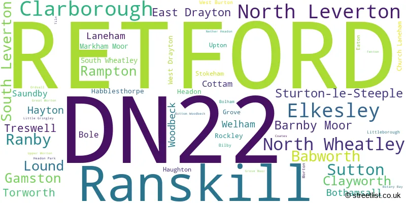
The largest settlement in the DN22 postal code is RETFORD followed by Ranskill, and Clarborough.
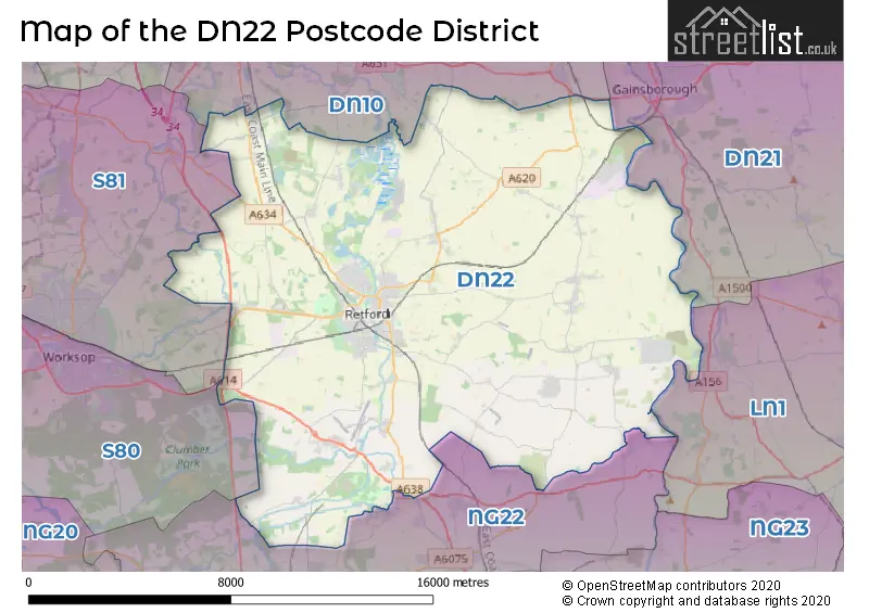
The DN22 Postcode shares a border with DN10 (Bawtry, Misterton, Beckingham), S80 (WORKSOP, Creswell, Whitwell), S81 (WORKSOP, Carlton-in-Lindrick, Langold), DN21 (GAINSBOROUGH, Kirton Lindsey, Scotter), LN1 (LINCOLN, Saxilby, Sturton By Stow) and NG22 (New Ollerton, Bilsthorpe, Tuxford).
The primary settlement in the DN22 postcode district is Retford, located in Nottinghamshire, England. The most significant post town in this district is also Retford. Other significant settlements in the DN22 postcode district include East Drayton, Gamston, North Leverton, Rampton, and South Leverton.
For the district DN22, we have data on 6 postcode sectors. Here's a breakdown: The sector DN22 0, covers North Leverton in Nottinghamshire. The sector DN22 1 is non-geographic. It's often designated for PO Boxes, large organisations, or special services. The sector DN22 6, covers Retford in Nottinghamshire. The sector DN22 7, covers Retford in Nottinghamshire. The sector DN22 8, covers Ranskill and Elkesley and Sutton and Ranby in Nottinghamshire. The sector DN22 9, covers Clarborough and North Wheatley and Clayworth and Sturton-Le-Steeple in Nottinghamshire.

Map of the DN22 Postcode District
Explore the DN22 postcode district by using our free interactive map.
When it comes to local government, postal geography often disregards political borders. However, for a breakdown in the DN22 District: the district mostly encompasses the Bassetlaw District area with a total of 1225 postcodes.
Weather Forecast for DN22
Press Button to Show Forecast for Sundown Adventure Land Rampton
| Time Period | Icon | Description | Temperature | Rain Probability | Wind |
|---|---|---|---|---|---|
| 18:00 to 21:00 | Partly cloudy (day) | 8.0°C (feels like 6.0°C) | 4.00% | N 11 mph | |
| 21:00 to 00:00 | Cloudy | 6.0°C (feels like 3.0°C) | 3.00% | NNW 9 mph |
Press Button to Show Forecast for Sundown Adventure Land Rampton
| Time Period | Icon | Description | Temperature | Rain Probability | Wind |
|---|---|---|---|---|---|
| 00:00 to 03:00 | Cloudy | 5.0°C (feels like 2.0°C) | 4.00% | NW 9 mph | |
| 03:00 to 06:00 | Cloudy | 5.0°C (feels like 2.0°C) | 7.00% | NNW 9 mph | |
| 06:00 to 09:00 | Cloudy | 5.0°C (feels like 1.0°C) | 4.00% | NW 11 mph | |
| 09:00 to 12:00 | Overcast | 7.0°C (feels like 3.0°C) | 8.00% | NNW 13 mph | |
| 12:00 to 15:00 | Overcast | 9.0°C (feels like 6.0°C) | 8.00% | NNW 11 mph | |
| 15:00 to 18:00 | Cloudy | 10.0°C (feels like 7.0°C) | 7.00% | N 11 mph | |
| 18:00 to 21:00 | Cloudy | 8.0°C (feels like 6.0°C) | 4.00% | NNE 7 mph | |
| 21:00 to 00:00 | Overcast | 5.0°C (feels like 3.0°C) | 7.00% | SSW 4 mph |
Press Button to Show Forecast for Sundown Adventure Land Rampton
| Time Period | Icon | Description | Temperature | Rain Probability | Wind |
|---|---|---|---|---|---|
| 00:00 to 03:00 | Cloudy | 5.0°C (feels like 2.0°C) | 4.00% | WSW 7 mph | |
| 03:00 to 06:00 | Cloudy | 4.0°C (feels like 1.0°C) | 4.00% | WSW 9 mph | |
| 06:00 to 09:00 | Cloudy | 5.0°C (feels like 2.0°C) | 6.00% | W 9 mph | |
| 09:00 to 12:00 | Overcast | 8.0°C (feels like 5.0°C) | 13.00% | NW 11 mph | |
| 12:00 to 15:00 | Cloudy | 10.0°C (feels like 7.0°C) | 9.00% | NNW 9 mph | |
| 15:00 to 18:00 | Light rain shower (day) | 9.0°C (feels like 7.0°C) | 29.00% | NNW 9 mph | |
| 18:00 to 21:00 | Partly cloudy (day) | 8.0°C (feels like 7.0°C) | 3.00% | N 7 mph | |
| 21:00 to 00:00 | Partly cloudy (night) | 4.0°C (feels like 2.0°C) | 2.00% | NE 4 mph |
Press Button to Show Forecast for Sundown Adventure Land Rampton
| Time Period | Icon | Description | Temperature | Rain Probability | Wind |
|---|---|---|---|---|---|
| 00:00 to 03:00 | Partly cloudy (night) | 2.0°C (feels like 0.0°C) | 1.00% | NNE 4 mph | |
| 03:00 to 06:00 | Partly cloudy (night) | 1.0°C (feels like -1.0°C) | 2.00% | N 4 mph | |
| 06:00 to 09:00 | Cloudy | 3.0°C (feels like 1.0°C) | 6.00% | NW 4 mph | |
| 09:00 to 12:00 | Cloudy | 8.0°C (feels like 6.0°C) | 7.00% | ENE 7 mph | |
| 12:00 to 15:00 | Overcast | 9.0°C (feels like 8.0°C) | 13.00% | E 7 mph | |
| 15:00 to 18:00 | Cloudy | 10.0°C (feels like 8.0°C) | 12.00% | ESE 7 mph | |
| 18:00 to 21:00 | Cloudy | 9.0°C (feels like 6.0°C) | 12.00% | ESE 9 mph | |
| 21:00 to 00:00 | Cloudy | 6.0°C (feels like 4.0°C) | 13.00% | E 9 mph |
Press Button to Show Forecast for Sundown Adventure Land Rampton
| Time Period | Icon | Description | Temperature | Rain Probability | Wind |
|---|---|---|---|---|---|
| 00:00 to 03:00 | Cloudy | 6.0°C (feels like 3.0°C) | 15.00% | E 7 mph | |
| 03:00 to 06:00 | Overcast | 6.0°C (feels like 3.0°C) | 23.00% | E 7 mph | |
| 06:00 to 09:00 | Cloudy | 6.0°C (feels like 4.0°C) | 19.00% | E 7 mph | |
| 09:00 to 12:00 | Overcast | 9.0°C (feels like 7.0°C) | 22.00% | E 9 mph | |
| 12:00 to 15:00 | Cloudy | 11.0°C (feels like 9.0°C) | 20.00% | E 9 mph | |
| 15:00 to 18:00 | Cloudy | 12.0°C (feels like 10.0°C) | 21.00% | ENE 9 mph | |
| 18:00 to 21:00 | Cloudy | 10.0°C (feels like 8.0°C) | 14.00% | ENE 9 mph | |
| 21:00 to 00:00 | Cloudy | 8.0°C (feels like 6.0°C) | 14.00% | ENE 9 mph |
Where is the DN22 Postcode District?
The data's postcode district, DN22, is located in the town of Retford. It is near several other towns including Worksop to the west, Gainsborough to the northeast, Lincoln to the southeast, Doncaster to the northwest, Mansfield to the southwest, and Newark to the south. The distance from Retford to London is approximately 129.74 miles.
The district is within the post town of RETFORD.
The sector has postcodes within the nation of England.
The DN22 Postcode District is in the North Nottinghamshire region of Derbyshire and Nottinghamshire within the East Midlands (England).
| Postcode Sector | Delivery Office |
|---|---|
| DN22 0 | Retford Delivery Office |
| DN22 6 | Retford Delivery Office |
| DN22 7 | Retford Delivery Office |
| DN22 8 | Retford Delivery Office |
| DN22 9 | Retford Delivery Office |
| D | N | 2 | 2 | - | X | X | X |
| D | N | 2 | 2 | Space | Numeric | Letter | Letter |
Tourist Attractions within the Postcode Area
We found 1 visitor attractions within the DN22 postcode area
| Bassetlaw Museum |
|---|
| Museums & Art Galleries |
| Museum and / or Art Gallery |
| View Bassetlaw Museum on Google Maps |
Current Monthly Rental Prices
| # Bedrooms | Min Price | Max Price | Avg Price |
|---|---|---|---|
| £417 | £583 | £500 | |
| 1 | £455 | £598 | £510 |
| 2 | £550 | £850 | £680 |
| 3 | £425 | £1,400 | £795 |
| 4 | £1,200 | £1,300 | £1,250 |
Current House Prices
| # Bedrooms | Min Price | Max Price | Avg Price |
|---|---|---|---|
| £105,000 | £1,000,000 | £335,294 | |
| 1 | £80,000 | £180,000 | £116,250 |
| 2 | £60,000 | £340,000 | £169,375 |
| 3 | £52,500 | £1,000,000 | £257,512 |
| 4 | £155,000 | £850,000 | £398,078 |
| 5 | £180,000 | £1,325,000 | £647,998 |
| 6 | £550,000 | £1,250,000 | £846,111 |
| 7 | £325,000 | £375,000 | £350,000 |
Estate Agents who Operate in the DN22 District
| Logo | Name | Brand Name | Address | Contact Number | Total Properties |
|---|---|---|---|---|---|
 | Retford | William H. Brown | Grove Street, Retford, DN22 6JR | 01777 802239 | 57 |
 | Retford | Brown & Co | 29 - 33 Grove Street, Retford, DN22 6JP | 01777 809431 | 54 |
 | Retford | Newton Fallowell | 7 New Street, Retford, DN22 6EG | 01777 802231 | 48 |
 | Retford | Alexander Jacob Ltd | 11 Grove Street, Retford, DN22 6JP | 01777 809445 | 47 |
 | Retford | Burgin Atkinson | Retford Enterprise Centre, Randall Way, Retford, DN22 7GR | 01777 809443 | 24 |
- Askham
- Babworth
- Barnby Moor
- Beckingham
- Blyth
- Bole
- Bolham
- Bothamsall
- Clarborough
- Clayworth
- Cottam
- Darlton
- East Drayton
- Eaton
- Elkesley
- Fenton
- Gamston
- Grove
- Hayton
- Headon
- Laneham
- Lound
- Markham Moor
- Marton
- Milton
- Morton
- Nether Headon
- North Leverton with Habblesthorpe
- North Wheatley
- Osberton
- Rampton
- Ranby
- Ranskill
- Retford
- Rockley
- Saundby
- South Leverton
- South Wheatley
- Stokeham
- Sturton le Steeple
- Sutton cum Lound
- Torworth
- Treswell
- Upton
- Walesby
- Welham
- West Drayton
- Woodbeck
- Worksop
| Type of Property | 2018 Average | 2018 Sales | 2017 Average | 2017 Sales | 2016 Average | 2016 Sales | 2015 Average | 2015 Sales |
|---|---|---|---|---|---|---|---|---|
| Detached | £251,904 | 323 | £252,155 | 298 | £239,020 | 377 | £228,639 | 298 |
| Semi-Detached | £143,974 | 199 | £131,568 | 213 | £128,141 | 234 | £127,062 | 196 |
| Terraced | £123,235 | 163 | £120,408 | 143 | £116,069 | 140 | £125,713 | 132 |
| Flats | £108,740 | 26 | £118,643 | 23 | £104,755 | 26 | £86,708 | 19 |