The DT7 postcode district is a postal district located in the DT Dorchester postcode area with a population of 5,568 residents according to the 2021 England and Wales Census.
The area of the DT7 postcode district is 9.52 square miles which is 24.66 square kilometres or 6,093.97 acres.
Currently, the DT7 district has about 283 postcode units spread across 1 geographic postcode sectors.
Given that each sector allows for 400 unique postcode combinations, the district has a capacity of 400 postcodes. With 283 postcodes already in use, this leaves 117 units available.
The largest settlement in the DT7 postal code is LYME REGIS followed by Uplyme, and Rousdon.
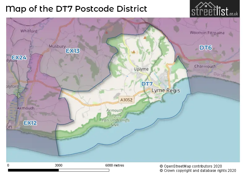
The postcode area has a boundary with The English Channel.
The DT7 Postcode shares a border with EX12 (SEATON, Beer, Branscombe), EX13 (AXMINSTER, Kilmington, Hawkchurch) and DT6 (BRIDPORT, Charmouth, Burton Bradstock).
The DT7 postcode district primarily consists of the settlement of Lyme Regis in Devon. The most significant postal town in this district is Lyme Regis. Additionally, there are other significant settlements in the area such as Harcombe, Rocombe, Rousdon, Uplyme, and Ware, all located within Devon.
For the district DT7, we have data on 1 postcode sectors. Here's a breakdown: The sector DT7 3, covers Lyme Regis in Dorset. The sector DT7 3, covers Uplyme in Devon.
DT7 Postcode Sectors

Map of the DT7 Postcode District
Explore the DT7 postcode district by using our free interactive map.
When it comes to local government, postal geography often disregards political borders. However, for a breakdown in the DT7 District: the district mostly encompasses the Dorset (192 postcodes), and finally, the East Devon District area (92 postcodes).
Recent House Sales in DT7
| Date | Price | Address |
|---|---|---|
| 15/09/2023 | £200,000 | Talbot Road, Lyme Regis, DT7 3BB |
| 28/08/2023 | £468,000 | Fairfield Park, Lyme Regis, DT7 3DS |
| 23/08/2023 | £1,150,000 | Coram Court, Lyme Regis, DT7 3GE |
| 21/08/2023 | £411,055 | Mill Green, Lyme Regis, DT7 3PL |
| 18/08/2023 | £637,500 | Woodmead Road, Lyme Regis, DT7 3AB |
| 17/08/2023 | £324,850 | Summerhill Road, Lyme Regis, DT7 3DT |
| 14/08/2023 | £635,000 | Old Home Farm, Rousdon, Lyme Regis, DT7 3YL |
| 09/08/2023 | £755,000 | Harcombe, Lyme Regis, DT7 3RN |
| 09/08/2023 | £225,500 | Broad Street, Lyme Regis, DT7 3QE |
| 08/08/2023 | £450,000 | Jordan, Lyme Regis, DT7 3AQ |
Weather Forecast for DT7
Press Button to Show Forecast for Lyme Regis
| Time Period | Icon | Description | Temperature | Rain Probability | Wind |
|---|---|---|---|---|---|
| 00:00 to 03:00 | Partly cloudy (night) | 8.0°C (feels like 6.0°C) | 0.00% | NNE 9 mph | |
| 03:00 to 06:00 | Partly cloudy (night) | 7.0°C (feels like 5.0°C) | 1.00% | NE 9 mph | |
| 06:00 to 09:00 | Partly cloudy (day) | 7.0°C (feels like 4.0°C) | 1.00% | NE 9 mph | |
| 09:00 to 12:00 | Cloudy | 9.0°C (feels like 7.0°C) | 3.00% | ENE 7 mph | |
| 12:00 to 15:00 | Cloudy | 11.0°C (feels like 9.0°C) | 3.00% | N 7 mph | |
| 15:00 to 18:00 | Cloudy | 12.0°C (feels like 10.0°C) | 5.00% | NNW 7 mph | |
| 18:00 to 21:00 | Cloudy | 12.0°C (feels like 10.0°C) | 4.00% | N 7 mph | |
| 21:00 to 00:00 | Cloudy | 10.0°C (feels like 8.0°C) | 5.00% | N 7 mph |
Press Button to Show Forecast for Lyme Regis
| Time Period | Icon | Description | Temperature | Rain Probability | Wind |
|---|---|---|---|---|---|
| 00:00 to 03:00 | Cloudy | 9.0°C (feels like 7.0°C) | 7.00% | NNE 7 mph | |
| 03:00 to 06:00 | Partly cloudy (night) | 8.0°C (feels like 6.0°C) | 1.00% | NNE 7 mph | |
| 06:00 to 09:00 | Partly cloudy (day) | 7.0°C (feels like 5.0°C) | 1.00% | NNE 7 mph | |
| 09:00 to 12:00 | Partly cloudy (day) | 9.0°C (feels like 7.0°C) | 1.00% | NNE 9 mph | |
| 12:00 to 15:00 | Cloudy | 11.0°C (feels like 9.0°C) | 5.00% | NNE 11 mph | |
| 15:00 to 18:00 | Overcast | 11.0°C (feels like 9.0°C) | 8.00% | NNE 11 mph | |
| 18:00 to 21:00 | Cloudy | 11.0°C (feels like 8.0°C) | 7.00% | NE 9 mph | |
| 21:00 to 00:00 | Cloudy | 9.0°C (feels like 6.0°C) | 6.00% | NE 9 mph |
Press Button to Show Forecast for Lyme Regis
| Time Period | Icon | Description | Temperature | Rain Probability | Wind |
|---|---|---|---|---|---|
| 00:00 to 03:00 | Clear night | 7.0°C (feels like 5.0°C) | 3.00% | NE 9 mph | |
| 03:00 to 06:00 | Partly cloudy (night) | 6.0°C (feels like 3.0°C) | 2.00% | NE 9 mph | |
| 06:00 to 09:00 | Partly cloudy (day) | 6.0°C (feels like 3.0°C) | 2.00% | NNE 9 mph | |
| 09:00 to 12:00 | Cloudy | 8.0°C (feels like 6.0°C) | 6.00% | NE 9 mph | |
| 12:00 to 15:00 | Overcast | 10.0°C (feels like 8.0°C) | 12.00% | NNE 7 mph | |
| 15:00 to 18:00 | Cloudy | 10.0°C (feels like 8.0°C) | 17.00% | N 9 mph | |
| 18:00 to 21:00 | Cloudy | 9.0°C (feels like 7.0°C) | 16.00% | N 7 mph | |
| 21:00 to 00:00 | Cloudy | 9.0°C (feels like 6.0°C) | 12.00% | NNE 9 mph |
Press Button to Show Forecast for Lyme Regis
| Time Period | Icon | Description | Temperature | Rain Probability | Wind |
|---|---|---|---|---|---|
| 00:00 to 03:00 | Cloudy | 8.0°C (feels like 5.0°C) | 7.00% | NNE 9 mph | |
| 03:00 to 06:00 | Cloudy | 7.0°C (feels like 5.0°C) | 5.00% | NE 9 mph | |
| 06:00 to 09:00 | Cloudy | 7.0°C (feels like 5.0°C) | 5.00% | NE 9 mph | |
| 09:00 to 12:00 | Partly cloudy (day) | 9.0°C (feels like 7.0°C) | 2.00% | NE 11 mph | |
| 12:00 to 15:00 | Cloudy | 11.0°C (feels like 9.0°C) | 6.00% | NNE 9 mph | |
| 15:00 to 18:00 | Cloudy | 12.0°C (feels like 10.0°C) | 7.00% | N 9 mph | |
| 18:00 to 21:00 | Cloudy | 12.0°C (feels like 10.0°C) | 7.00% | N 9 mph | |
| 21:00 to 00:00 | Partly cloudy (night) | 10.0°C (feels like 8.0°C) | 3.00% | NNW 9 mph |
Where is the DT7 Postcode District?
The postcode district DT7 is located in the town of Lyme Regis. It is in close proximity to the nearby towns of Axminster (to the north, 4.17 miles away), Seaton (to the west, 5.12 miles away), Bridport (to the east, 7.56 miles away), Honiton (to the northwest, 11.76 miles away), and Beaminster (to the northeast, 11.95 miles away). In terms of distance, London is located 134.76 miles away from DT7.
The district is within the post town of LYME REGIS.
The sector has postcodes within the nation of England.
The DT7 Postcode District is in the Devon CC region of Devon within the South West (England).
Postcode Sectors within the DT7 District
| Postcode Sector | Delivery Office |
|---|---|
| DT7 3 | Lyme Regis Scale Payment Delivery Office |
| D | T | 7 | - | X | X | X |
| D | T | 7 | Space | Numeric | Letter | Letter |
Current Monthly Rental Prices
| # Bedrooms | Min Price | Max Price | Avg Price |
|---|---|---|---|
| 3 | £2,750 | £7,583 | £5,167 |
| 6 | £5,000 | £5,000 | £5,000 |
Current House Prices
| # Bedrooms | Min Price | Max Price | Avg Price |
|---|---|---|---|
| £121,000 | £650,000 | £385,500 | |
| 1 | £125,000 | £425,000 | £265,444 |
| 2 | £79,950 | £655,000 | £314,153 |
| 3 | £179,995 | £750,000 | £458,966 |
| 4 | £310,000 | £1,300,000 | £771,171 |
| 5 | £525,000 | £1,500,000 | £995,392 |
| 6 | £545,000 | £545,000 | £545,000 |
| 7 | £1,250,000 | £2,250,000 | £1,750,000 |
| 9 | £1,200,000 | £1,200,000 | £1,200,000 |
Estate Agents who Operate in the DT7 District
| Logo | Name | Brand Name | Address | Contact Number | Total Properties |
|---|---|---|---|---|---|
 | Lyme Regis | Martin Diplock Chartered Surveyors | 36 Broad Street, Lyme Regis, Dorset, DT7 3QF | 01297 300961 | 45 |
 | Lyme Regis | Fortnam Smith & Banwell | 53 Broad Street Lyme Regis DT7 3QF | 01297 300884 | 24 |
 | Southampton | Savills New Homes | Mountbatten House, 1 Grosvenor Square, Southampton SO15 2BZ | 0238 202 3797 | 9 |
 | Bridport | Stags | 32 South Street, Bridport, Dorset DT6 3NQ | 01308 800826 | 7 |
 | Weston Super Mare | David Plaister Ltd | 12 South Parade, Weston-super-Mare, North Somerset, BS23 1JN | 01934 317536 | 4 |
| Type of Property | 2018 Average | 2018 Sales | 2017 Average | 2017 Sales | 2016 Average | 2016 Sales | 2015 Average | 2015 Sales |
|---|---|---|---|---|---|---|---|---|
| Detached | £601,635 | 53 | £545,138 | 70 | £477,943 | 73 | £458,425 | 64 |
| Semi-Detached | £304,579 | 19 | £348,219 | 18 | £260,471 | 26 | £282,865 | 27 |
| Terraced | £366,471 | 17 | £293,979 | 14 | £333,258 | 20 | £320,077 | 31 |
| Flats | £226,600 | 35 | £218,122 | 45 | £209,989 | 46 | £217,040 | 46 |
Hotels within the Postcode Area
We found 13 hotels and guest houses within the DT7 postcode area
The Mariners Hotel
Silver Street, Lyme Regis, Lyme Regis, lyme-regis-aireborough, DT7 3HS.
View details