The DT8 postcode district is a postal district located in the DT Dorchester postcode area with a population of 6,065 residents according to the 2021 England and Wales Census.
The area of the DT8 postcode district is 31.90 square miles which is 82.63 square kilometres or 20,417.62 acres.
Currently, the DT8 district has about 230 postcode units spread across 1 geographic postcode sectors.
Given that each sector allows for 400 unique postcode combinations, the district has a capacity of 400 postcodes. With 230 postcodes already in use, this leaves 170 units available.
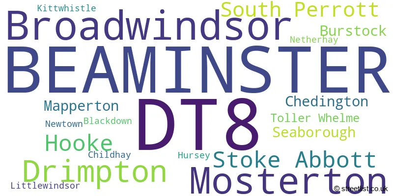
The largest settlement in the DT8 postal code is BEAMINSTER followed by Mosterton, and Broadwindsor.
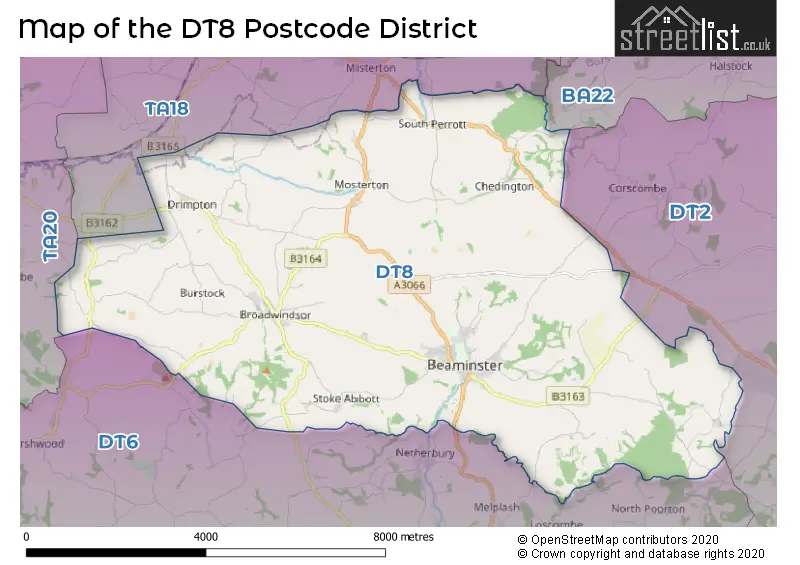
The DT8 Postcode shares a border with BA22 (Ilchester, East Coker, West Coker), TA18 (CREWKERNE, Misterton, Haselbury Plucknett), DT6 (BRIDPORT, Charmouth, Burton Bradstock) and DT2 (Crossways, Charminster, Puddletown).
In the DT8 postcode district, the primary settlement is Beaminster, which is located in the county of Dorset, England. Other significant settlements in this district include Broadwindsor, Drimpton, Mosterton, South Perrott, and Stoke Abbott. The most significant post town in this district is Beaminster.
For the district DT8, we have data on 1 postcode sectors. Here's a breakdown: The sector DT8 3, covers Beaminster and Broadwindsor in Dorset.
DT8 Postcode Sectors

Map of the DT8 Postcode District
Explore the DT8 postcode district by using our free interactive map.
When it comes to local government, postal geography often disregards political borders. However, for a breakdown in the DT8 District: the district mostly encompasses the Dorset area with a total of 233 postcodes.
Recent House Sales in DT8
| Date | Price | Address |
|---|---|---|
| 20/10/2023 | £175,000 | Broad Oak Avenue, Mosterton, Beaminster, DT8 3JH |
| 10/10/2023 | £258,000 | Riverside, Beaminster, DT8 3NJ |
| 06/10/2023 | £315,000 | Redlands Lane, Broadwindsor, Beaminster, DT8 3ST |
| 28/09/2023 | £525,000 | Shorts Lane, Beaminster, DT8 3BD |
| 22/09/2023 | £470,000 | Bridport Road, Drimpton, Beaminster, DT8 3RD |
| 22/09/2023 | £250,000 | East Street, Beaminster, DT8 3DT |
| 22/09/2023 | £590,000 | Marksmead, Drimpton, Beaminster, DT8 3RZ |
| 22/09/2023 | £283,000 | Yarn Barton, Broadwindsor, Beaminster, DT8 3QW |
| 20/09/2023 | £317,000 | Fleet Street, Beaminster, DT8 3EF |
| 01/09/2023 | £250,000 | Drimpton Road, Broadwindsor, Beaminster, DT8 3QN |
Weather Forecast for DT8
Press Button to Show Forecast for Beaminster
| Time Period | Icon | Description | Temperature | Rain Probability | Wind |
|---|---|---|---|---|---|
| 12:00 to 15:00 | Light rain | 10.0°C (feels like 8.0°C) | 76.00% | WSW 7 mph | |
| 15:00 to 18:00 | Light rain shower (day) | 11.0°C (feels like 9.0°C) | 35.00% | WSW 7 mph | |
| 18:00 to 21:00 | Cloudy | 10.0°C (feels like 9.0°C) | 8.00% | W 4 mph | |
| 21:00 to 00:00 | Cloudy | 7.0°C (feels like 5.0°C) | 4.00% | NW 7 mph |
Press Button to Show Forecast for Beaminster
| Time Period | Icon | Description | Temperature | Rain Probability | Wind |
|---|---|---|---|---|---|
| 00:00 to 03:00 | Cloudy | 6.0°C (feels like 4.0°C) | 4.00% | NNE 7 mph | |
| 03:00 to 06:00 | Cloudy | 5.0°C (feels like 3.0°C) | 4.00% | NNE 7 mph | |
| 06:00 to 09:00 | Cloudy | 6.0°C (feels like 3.0°C) | 6.00% | NE 7 mph | |
| 09:00 to 12:00 | Cloudy | 8.0°C (feels like 6.0°C) | 10.00% | ENE 9 mph | |
| 12:00 to 15:00 | Overcast | 10.0°C (feels like 8.0°C) | 19.00% | E 9 mph | |
| 15:00 to 18:00 | Cloudy | 10.0°C (feels like 8.0°C) | 16.00% | SE 7 mph | |
| 18:00 to 21:00 | Cloudy | 9.0°C (feels like 7.0°C) | 15.00% | ESE 7 mph | |
| 21:00 to 00:00 | Cloudy | 8.0°C (feels like 6.0°C) | 14.00% | E 7 mph |
Press Button to Show Forecast for Beaminster
| Time Period | Icon | Description | Temperature | Rain Probability | Wind |
|---|---|---|---|---|---|
| 00:00 to 03:00 | Cloudy | 7.0°C (feels like 5.0°C) | 20.00% | ENE 7 mph | |
| 03:00 to 06:00 | Light rain | 6.0°C (feels like 4.0°C) | 53.00% | NE 9 mph | |
| 06:00 to 09:00 | Cloudy | 6.0°C (feels like 3.0°C) | 50.00% | NE 11 mph | |
| 09:00 to 12:00 | Cloudy | 8.0°C (feels like 5.0°C) | 14.00% | NE 11 mph | |
| 12:00 to 15:00 | Cloudy | 11.0°C (feels like 8.0°C) | 16.00% | ENE 13 mph | |
| 15:00 to 18:00 | Cloudy | 11.0°C (feels like 8.0°C) | 23.00% | ENE 11 mph | |
| 18:00 to 21:00 | Light rain | 10.0°C (feels like 7.0°C) | 54.00% | NE 11 mph | |
| 21:00 to 00:00 | Light rain | 9.0°C (feels like 6.0°C) | 52.00% | NE 13 mph |
Press Button to Show Forecast for Beaminster
| Time Period | Icon | Description | Temperature | Rain Probability | Wind |
|---|---|---|---|---|---|
| 00:00 to 03:00 | Heavy rain | 8.0°C (feels like 4.0°C) | 74.00% | NNE 13 mph | |
| 03:00 to 06:00 | Light rain | 7.0°C (feels like 4.0°C) | 55.00% | NNE 13 mph | |
| 06:00 to 09:00 | Light rain | 7.0°C (feels like 4.0°C) | 50.00% | NNE 13 mph | |
| 09:00 to 12:00 | Light rain | 8.0°C (feels like 5.0°C) | 51.00% | N 13 mph | |
| 12:00 to 15:00 | Light rain shower (day) | 10.0°C (feels like 7.0°C) | 39.00% | N 16 mph | |
| 15:00 to 18:00 | Light rain shower (day) | 11.0°C (feels like 8.0°C) | 40.00% | NW 13 mph | |
| 18:00 to 21:00 | Cloudy | 11.0°C (feels like 9.0°C) | 11.00% | NW 9 mph | |
| 21:00 to 00:00 | Cloudy | 8.0°C (feels like 6.0°C) | 7.00% | W 7 mph |
Where is the DT8 Postcode District?
The postcode district DT8 is located in Beaminster, a town in Dorset. Beaminster is close to several nearby towns. To the north is Crewkerne, which is approximately 4.35 miles away. Bridport is located to the south and is about 5.53 miles away. Hinton St. George can be found to the northwest, roughly 6.38 miles away. Yeovil is situated to the northeast, with a distance of approximately 9.67 miles. In addition, Beaminster is 123.64 miles away from the center of London.
The district is within the post town of BEAMINSTER.
The sector has postcodes within the nation of England.
The DT8 Postcode District is in the Somerset region of Dorset and Somerset within the South West (England).
Postcode Sectors within the DT8 District
| Postcode Sector | Delivery Office |
|---|---|
| DT8 3 | Bridport Delivery Office |
| D | T | 8 | - | X | X | X |
| D | T | 8 | Space | Numeric | Letter | Letter |
Current Monthly Rental Prices
| # Bedrooms | Min Price | Max Price | Avg Price |
|---|---|---|---|
| 2 | £780 | £995 | £888 |
| 3 | £1,500 | £1,660 | £1,580 |
Current House Prices
| # Bedrooms | Min Price | Max Price | Avg Price |
|---|---|---|---|
| £245,000 | £385,000 | £315,000 | |
| 1 | £115,000 | £225,000 | £151,667 |
| 2 | £157,500 | £475,000 | £281,132 |
| 3 | £230,000 | £625,000 | £404,164 |
| 4 | £425,000 | £1,950,000 | £665,000 |
| 5 | £500,000 | £2,500,000 | £1,595,000 |
| 7 | £695,000 | £695,000 | £695,000 |
| 9 | £775,000 | £775,000 | £775,000 |
Estate Agents who Operate in the DT8 District
| Logo | Name | Brand Name | Address | Contact Number | Total Properties |
|---|---|---|---|---|---|
 | Beaminster | Mayfair Town & Country | 20 The Square, Beaminster, DT8 3AU | 01308 800705 | 21 |
 | Beaminster | Symonds & Sampson | 36 Hogshill Street, Beaminster, DT8 3AA | 01308 800941 | 16 |
 | Bridport | Stags | 32 South Street, Bridport, Dorset DT6 3NQ | 01308 800826 | 5 |
 | Bridport | Jackson-Stops | 47 South Street, Bridport, Dorset, DT6 3NY | 01308 800948 | 3 |
 | covering Dorchester | Purplebricks | Suite 7 First Floor Cranmore Drive Shirley Solihull B90 4RZ | 020 3834 8334 | 3 |
| Type of Property | 2018 Average | 2018 Sales | 2017 Average | 2017 Sales | 2016 Average | 2016 Sales | 2015 Average | 2015 Sales |
|---|---|---|---|---|---|---|---|---|
| Detached | £391,076 | 66 | £440,825 | 52 | £346,704 | 66 | £326,995 | 64 |
| Semi-Detached | £353,181 | 27 | £256,729 | 26 | £257,292 | 24 | £205,602 | 31 |
| Terraced | £232,395 | 30 | £249,006 | 28 | £290,819 | 34 | £224,600 | 24 |
| Flats | £113,181 | 8 | £129,230 | 15 | £117,427 | 11 | £137,269 | 13 |