The DT10 2 postcode sector stands on the Dorset and Somerset border.
Did you know? According to the 2021 Census, the DT10 2 postcode sector is home to a bustling 5,855 residents!
Given that each sector allows for 400 unique postcode combinations. Letters C, I, K, M, O and V are not allowed in the last two letters of a postcode. With 230 postcodes already in use, this leaves 170 units available.
The largest settlement in the DT10 2 postal code is Stalbridge followed by Hazelbury Bryan, and Kingston.
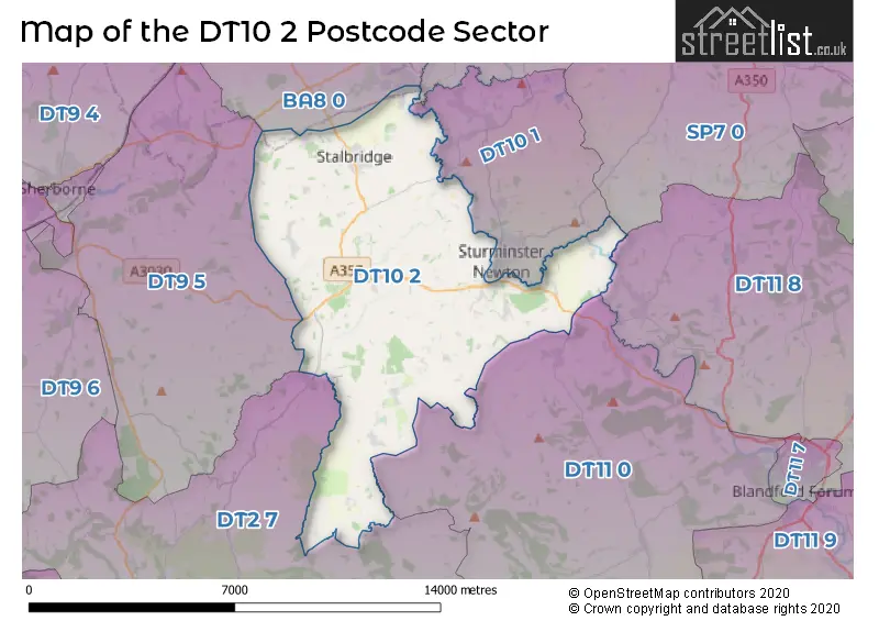
The DT10 2 Postcode shares a border with DT2 7 (Cerne Abbas, Piddletrenthide, Buckland Newton), DT9 5 (Milborne Port, Holwell, Longburton), DT10 1 (STURMINSTER NEWTON, Marnhull, Hinton St. Mary), DT11 0 (Milborne St. Andrew, Shillingstone, Okeford Fitzpaine), DT11 8 (Child Okeford, Blandford Camp, Pimperne), BA8 0 (Henstridge, TEMPLECOMBE, Horsington), SP7 0 (Fontmell Magna, Stour Row, Berwick St. John) and SP8 5 (Bourton, East Stour, GILLINGHAM).
The sector is within the post town of STURMINSTER NEWTON.
DT10 2 is a postcode sector within the DT9 postcode district which is within the DT Dorchester postcode area.
The Royal Mail delivery office for the DT10 2 postal sector is the unknown.
The area of the DT10 2 postcode sector is 33.62 square miles which is 87.09 square kilometres or 21,519.97 square acres.
Waterways within the DT10 2 postcode sector include the Stour.

Map of the DT10 2 Postcode Sector
Explore the DT10 2 postcode sector by using our free interactive map.
| D | T | 1 | 0 | - | 2 | X | X |
| D | T | 1 | 0 | Space | 2 | Letter | Letter |
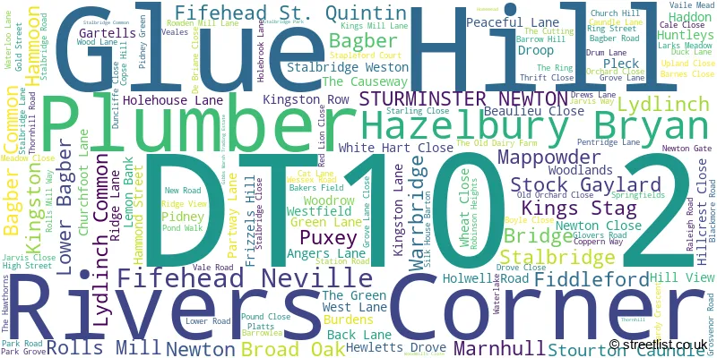
Official List of Streets
Kingston (11 Streets)
Stalbridge (58 Streets)
Stourton Caundle (8 Streets)
Stalbridge Weston (1 Streets)
Hazelbury Bryan (14 Streets)
Broad Oak (3 Streets)
Fifehead Neville (2 Streets)
Mappowder (2 Streets)
Rivers Corner (1 Streets)
STURMINSTER NEWTON (4 Streets)
Glue Hill (4 Streets)
Lydlinch (4 Streets)
Kings Stag (3 Streets)
Marnhull (1 Streets)
Bridge (1 Streets)
Newton (2 Streets)
Lower Bagber (1 Streets)
Unofficial Streets or Alternative Spellings
Okeford Fitzpaine
CASTLE LANESTURMINSTER NEWTON
BRIDGE STREETHenstridge
LANDSHIRE LANE STALBRIDGE ROADWeather Forecast for DT10 2
Press Button to Show Forecast for Sturminster Newton
| Time Period | Icon | Description | Temperature | Rain Probability | Wind |
|---|---|---|---|---|---|
| 18:00 to 21:00 | Cloudy | 11.0°C (feels like 9.0°C) | 4.00% | NNE 9 mph | |
| 21:00 to 00:00 | Cloudy | 6.0°C (feels like 5.0°C) | 4.00% | N 4 mph |
Press Button to Show Forecast for Sturminster Newton
| Time Period | Icon | Description | Temperature | Rain Probability | Wind |
|---|---|---|---|---|---|
| 00:00 to 03:00 | Cloudy | 6.0°C (feels like 5.0°C) | 5.00% | N 2 mph | |
| 03:00 to 06:00 | Cloudy | 5.0°C (feels like 4.0°C) | 5.00% | NW 2 mph | |
| 06:00 to 09:00 | Cloudy | 6.0°C (feels like 5.0°C) | 4.00% | NW 2 mph | |
| 09:00 to 12:00 | Cloudy | 10.0°C (feels like 8.0°C) | 8.00% | NNW 7 mph | |
| 12:00 to 15:00 | Cloudy | 11.0°C (feels like 10.0°C) | 5.00% | N 9 mph | |
| 15:00 to 18:00 | Cloudy | 13.0°C (feels like 11.0°C) | 4.00% | NNW 9 mph | |
| 18:00 to 21:00 | Partly cloudy (day) | 11.0°C (feels like 10.0°C) | 1.00% | NNW 7 mph | |
| 21:00 to 00:00 | Cloudy | 6.0°C (feels like 5.0°C) | 4.00% | E 4 mph |
Press Button to Show Forecast for Sturminster Newton
| Time Period | Icon | Description | Temperature | Rain Probability | Wind |
|---|---|---|---|---|---|
| 00:00 to 03:00 | Partly cloudy (night) | 5.0°C (feels like 3.0°C) | 0.00% | SW 4 mph | |
| 03:00 to 06:00 | Partly cloudy (night) | 4.0°C (feels like 2.0°C) | 1.00% | W 4 mph | |
| 06:00 to 09:00 | Cloudy | 5.0°C (feels like 3.0°C) | 4.00% | W 4 mph | |
| 09:00 to 12:00 | Partly cloudy (day) | 9.0°C (feels like 8.0°C) | 3.00% | WNW 7 mph | |
| 12:00 to 15:00 | Overcast | 11.0°C (feels like 9.0°C) | 12.00% | WNW 11 mph | |
| 15:00 to 18:00 | Cloudy | 12.0°C (feels like 9.0°C) | 6.00% | WNW 9 mph | |
| 18:00 to 21:00 | Cloudy | 10.0°C (feels like 8.0°C) | 5.00% | WNW 9 mph | |
| 21:00 to 00:00 | Cloudy | 7.0°C (feels like 6.0°C) | 7.00% | WNW 4 mph |
Press Button to Show Forecast for Sturminster Newton
| Time Period | Icon | Description | Temperature | Rain Probability | Wind |
|---|---|---|---|---|---|
| 00:00 to 03:00 | Partly cloudy (night) | 5.0°C (feels like 4.0°C) | 3.00% | WNW 4 mph | |
| 03:00 to 06:00 | Cloudy | 5.0°C (feels like 3.0°C) | 9.00% | E 4 mph | |
| 06:00 to 09:00 | Cloudy | 6.0°C (feels like 4.0°C) | 11.00% | SSE 4 mph | |
| 09:00 to 12:00 | Cloudy | 9.0°C (feels like 7.0°C) | 14.00% | SE 9 mph | |
| 12:00 to 15:00 | Cloudy | 10.0°C (feels like 8.0°C) | 18.00% | S 9 mph | |
| 15:00 to 18:00 | Cloudy | 10.0°C (feels like 8.0°C) | 18.00% | ESE 9 mph | |
| 18:00 to 21:00 | Cloudy | 10.0°C (feels like 8.0°C) | 17.00% | SSE 9 mph | |
| 21:00 to 00:00 | Cloudy | 8.0°C (feels like 6.0°C) | 16.00% | ESE 7 mph |
Press Button to Show Forecast for Sturminster Newton
| Time Period | Icon | Description | Temperature | Rain Probability | Wind |
|---|---|---|---|---|---|
| 00:00 to 03:00 | Overcast | 7.0°C (feels like 5.0°C) | 22.00% | ESE 7 mph | |
| 03:00 to 06:00 | Light rain | 7.0°C (feels like 5.0°C) | 48.00% | E 7 mph | |
| 06:00 to 09:00 | Cloudy | 7.0°C (feels like 5.0°C) | 17.00% | ENE 7 mph | |
| 09:00 to 12:00 | Cloudy | 10.0°C (feels like 8.0°C) | 19.00% | E 11 mph | |
| 12:00 to 15:00 | Light rain | 11.0°C (feels like 9.0°C) | 51.00% | ESE 11 mph | |
| 15:00 to 18:00 | Light rain shower (day) | 12.0°C (feels like 9.0°C) | 41.00% | ENE 11 mph | |
| 18:00 to 21:00 | Light rain shower (day) | 11.0°C (feels like 9.0°C) | 41.00% | ENE 9 mph | |
| 21:00 to 00:00 | Heavy rain | 9.0°C (feels like 7.0°C) | 78.00% | NE 9 mph |
Schools and Places of Education Within the DT10 2 Postcode Sector
Hazelbury Bryan Primary School
Community school
Droop, Sturminster Newton, Dorset, DT10 2ED
Head: Mrs Kelly Waring
Ofsted Rating: Good
Inspection: 2023-06-14 (314 days ago)
Website: Visit Hazelbury Bryan Primary School Website
Phone: 01258817492
Number of Pupils: 86
Stalbridge Church of England Primary School
Foundation school
Duck Lane, Stalbridge, Dorset, DT10 2LP
Head: Mr Simon Elledge
Ofsted Rating: Good
Inspection: 2023-03-14 (406 days ago)
Website: Visit Stalbridge Church of England Primary School Website
Phone: 01963362487
Number of Pupils: 187
House Prices in the DT10 2 Postcode Sector
| Type of Property | 2018 Average | 2018 Sales | 2017 Average | 2017 Sales | 2016 Average | 2016 Sales | 2015 Average | 2015 Sales |
|---|---|---|---|---|---|---|---|---|
| Detached | £400,638 | 29 | £460,416 | 48 | £405,547 | 49 | £338,459 | 44 |
| Semi-Detached | £263,083 | 26 | £263,378 | 27 | £260,086 | 39 | £244,652 | 23 |
| Terraced | £232,233 | 15 | £246,086 | 11 | £195,268 | 11 | £211,395 | 19 |
| Flats | £87,000 | 1 | £119,000 | 4 | £0 | 0 | £104,500 | 2 |
| The DT10 2 Sector is within these Local Authorities |
|
|---|---|
| The DT10 2 Sector is within these Counties |
|
| The DT10 2 Sector is within these Water Company Areas |
|