The DY10 2 postcode sector is within the county of Worcestershire.
Did you know? According to the 2021 Census, the DY10 2 postcode sector is home to a bustling 11,989 residents!
Given that each sector allows for 400 unique postcode combinations. Letters C, I, K, M, O and V are not allowed in the last two letters of a postcode. With 255 postcodes already in use, this leaves 145 units available.
The DY10 2 postal code covers the settlement of KIDDERMINSTER.
The DY10 2 Postcode shares a border with DY11 6 (KIDDERMINSTER), DY10 1 (KIDDERMINSTER), DY10 3 (KIDDERMINSTER, Cookley, Blakedown) and DY11 5 (KIDDERMINSTER, Wolverley, Caunsall).
The sector is within the post town of KIDDERMINSTER.
DY10 2 is a postcode sector within the DY10 postcode district which is within the DY Dudley postcode area.
The Royal Mail delivery office for the DY10 2 postal sector is the Kidderminster Delivery Office.
The area of the DY10 2 postcode sector is 1.39 square miles which is 3.60 square kilometres or 889.07 square acres.
Waterways within the DY10 2 postcode sector include the Staffordshire & Worcestershire Canal.

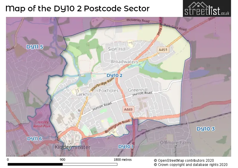
Map of the DY10 2 Postcode Sector
Explore the DY10 2 postcode sector by using our free interactive map.
| D | Y | 1 | 0 | - | 2 | X | X |
| D | Y | 1 | 0 | Space | 2 | Letter | Letter |
Official List of Streets
KIDDERMINSTER (141 Streets)
Unofficial Streets or Alternative Spellings
KIDDERMINSTER
BROMSGROVE STREET GREENHILL INDUSTRIAL ESTATE HURCOTT LANE LESWELL GROVE LESWELL LANE LESWELL STREET LINDEN AVENUE LION SQUARE LION STREET LOWER MILL STREET MERTON CLOSE TRINITY GRANGE VICAR STREET WORCESTER STREET ARCH HILL BLACK HORSE LANE BROADWATERS BRIDGE BRONWENINGHAM COURT CROWN LANE DEANSWAY HOUSE GRASMERE CLOSE HORSE FAIR IVOR WHITE COURT JERUSALEM COURT OXBOW WAY PARK GATE ROAD PITTS LANE RACK HILL ST GEORGES RINGWAY ST MARYS RINGWAY ST. MARY STREET ST. MARYS PLACE ST. MARYS STREET STOURVALE DRIVE SWAN CENTRE SERVICE DECK THE RINGWAY THE ZIG ZAG UNION STREET YOURK COURTBlakedown
BIRMINGHAM ROADCookley
WOLVERHAMPTON ROADWolverley
WOLVERLEY ROADIsmere
STOURBRIDGE ROADWeather Forecast for DY10 2
Press Button to Show Forecast for Kidderminster
| Time Period | Icon | Description | Temperature | Rain Probability | Wind |
|---|---|---|---|---|---|
| 03:00 to 06:00 | Cloudy | 6.0°C (feels like 4.0°C) | 4.00% | NW 2 mph | |
| 06:00 to 09:00 | Cloudy | 5.0°C (feels like 4.0°C) | 3.00% | NNW 2 mph | |
| 09:00 to 12:00 | Cloudy | 9.0°C (feels like 7.0°C) | 4.00% | NNE 4 mph | |
| 12:00 to 15:00 | Overcast | 11.0°C (feels like 10.0°C) | 7.00% | N 7 mph | |
| 15:00 to 18:00 | Overcast | 12.0°C (feels like 10.0°C) | 7.00% | N 9 mph | |
| 18:00 to 21:00 | Cloudy | 11.0°C (feels like 10.0°C) | 5.00% | N 7 mph | |
| 21:00 to 00:00 | Cloudy | 9.0°C (feels like 8.0°C) | 5.00% | NNE 4 mph |
Press Button to Show Forecast for Kidderminster
| Time Period | Icon | Description | Temperature | Rain Probability | Wind |
|---|---|---|---|---|---|
| 00:00 to 03:00 | Clear night | 7.0°C (feels like 6.0°C) | 1.00% | NE 4 mph | |
| 03:00 to 06:00 | Cloudy | 6.0°C (feels like 5.0°C) | 4.00% | NE 2 mph | |
| 06:00 to 09:00 | Overcast | 6.0°C (feels like 5.0°C) | 8.00% | NNE 2 mph | |
| 09:00 to 12:00 | Cloudy | 8.0°C (feels like 7.0°C) | 6.00% | NNE 7 mph | |
| 12:00 to 15:00 | Overcast | 10.0°C (feels like 8.0°C) | 9.00% | NE 9 mph | |
| 15:00 to 18:00 | Overcast | 11.0°C (feels like 10.0°C) | 12.00% | NE 9 mph | |
| 18:00 to 21:00 | Cloudy | 11.0°C (feels like 9.0°C) | 9.00% | NE 7 mph | |
| 21:00 to 00:00 | Cloudy | 8.0°C (feels like 6.0°C) | 8.00% | ENE 4 mph |
Press Button to Show Forecast for Kidderminster
| Time Period | Icon | Description | Temperature | Rain Probability | Wind |
|---|---|---|---|---|---|
| 00:00 to 03:00 | Cloudy | 6.0°C (feels like 5.0°C) | 8.00% | ENE 4 mph | |
| 03:00 to 06:00 | Cloudy | 5.0°C (feels like 4.0°C) | 8.00% | NE 2 mph | |
| 06:00 to 09:00 | Overcast | 5.0°C (feels like 4.0°C) | 13.00% | NE 4 mph | |
| 09:00 to 12:00 | Overcast | 8.0°C (feels like 6.0°C) | 13.00% | ESE 4 mph | |
| 12:00 to 15:00 | Light rain | 9.0°C (feels like 8.0°C) | 44.00% | SE 7 mph | |
| 15:00 to 18:00 | Light rain | 10.0°C (feels like 8.0°C) | 44.00% | SE 7 mph | |
| 18:00 to 21:00 | Cloudy | 9.0°C (feels like 8.0°C) | 16.00% | ENE 4 mph | |
| 21:00 to 00:00 | Cloudy | 8.0°C (feels like 7.0°C) | 15.00% | ENE 4 mph |
Press Button to Show Forecast for Kidderminster
| Time Period | Icon | Description | Temperature | Rain Probability | Wind |
|---|---|---|---|---|---|
| 00:00 to 03:00 | Cloudy | 7.0°C (feels like 6.0°C) | 10.00% | ENE 4 mph | |
| 03:00 to 06:00 | Overcast | 7.0°C (feels like 6.0°C) | 10.00% | NNE 4 mph | |
| 06:00 to 09:00 | Cloudy | 7.0°C (feels like 6.0°C) | 9.00% | NNE 4 mph | |
| 09:00 to 12:00 | Cloudy | 9.0°C (feels like 8.0°C) | 8.00% | NE 7 mph | |
| 12:00 to 15:00 | Overcast | 11.0°C (feels like 10.0°C) | 15.00% | NE 9 mph | |
| 15:00 to 18:00 | Cloudy | 13.0°C (feels like 11.0°C) | 16.00% | NNE 9 mph | |
| 18:00 to 21:00 | Partly cloudy (day) | 12.0°C (feels like 10.0°C) | 9.00% | NE 9 mph | |
| 21:00 to 00:00 | Partly cloudy (night) | 9.0°C (feels like 8.0°C) | 12.00% | NE 7 mph |
Schools and Places of Education Within the DY10 2 Postcode Sector
Holy Trinity School
Free schools
Birmingham Road, Kidderminster, Worcestershire, DY10 2BY
Head: Mr Ian Williams
Ofsted Rating: Good
Inspection: 2022-09-22 (576 days ago)
Website: Visit Holy Trinity School Website
Phone: 01562822929
Number of Pupils: 737
St Mary's CofE (VA) Primary School
Voluntary aided school
Stoney Lane, Kidderminster, Worcestershire, DY10 2LX
Head: Miss Sarah Perrett
Ofsted Rating: Requires improvement
Inspection: 2022-11-10 (527 days ago)
Website: Visit St Mary's CofE (VA) Primary School Website
Phone: 01562824327
Number of Pupils: 208
St Oswald's CofE Primary School
Academy converter
Sion Avenue, Kidderminster, Worcestershire, DY10 2YL
Head: Mrs Carol Reece
Ofsted Rating: Good
Inspection: 2022-05-12 (709 days ago)
Website: Visit St Oswald's CofE Primary School Website
Phone: 01562751056
Number of Pupils: 156
House Prices in the DY10 2 Postcode Sector
| Type of Property | 2018 Average | 2018 Sales | 2017 Average | 2017 Sales | 2016 Average | 2016 Sales | 2015 Average | 2015 Sales |
|---|---|---|---|---|---|---|---|---|
| Detached | £234,077 | 35 | £224,983 | 35 | £204,888 | 35 | £213,651 | 54 |
| Semi-Detached | £173,460 | 77 | £165,644 | 67 | £165,478 | 72 | £146,609 | 91 |
| Terraced | £141,471 | 61 | £144,003 | 59 | £137,519 | 70 | £131,457 | 80 |
| Flats | £71,602 | 22 | £89,745 | 28 | £84,867 | 22 | £87,797 | 21 |
Important Postcodes DY10 2 in the Postcode Sector
DY10 2BG is the postcode for KIDDERMINSTER MEDICAL CENTRE, COVENTRY STREET, KIDDERMINSTER, and Kidderminster Medical Centre, Coventry Street
DY10 2BX is the postcode for St. Georges C of E Primary School, Birmingham Road
DY10 2BY is the postcode for Holy Trinity School, Birmingham Road
DY10 2DH is the postcode for Jobcentre Plus, Crown House
DY10 2JE is the postcode for Wyre Forest Day Opportunities, 92 Orchard Street
DY10 2JG is the postcode for Church Street Surgery, David Corbet House, 2 Callows Lane
DY10 2JX is the postcode for Wyre Forest District Council, Duke House
DY10 2LX is the postcode for ST MARYS C OF E PRIMARY SCHOOL, STONEY LANE, KIDDERMINSTER, ST MARYS C OF E PRIMARY SCHOOL, STONEY LANE, and St. Marys C of E Primary School, Stoney Lane
DY10 2YL is the postcode for St. Oswald's C of E Primary School, Sion Avenue, and St. Oswalds C of E First School, Sion Avenue
| The DY10 2 Sector is within these Local Authorities |
|
|---|---|
| The DY10 2 Sector is within these Counties |
|
| The DY10 2 Sector is within these Water Company Areas |
|