The DY7 postcode district is a postal district located in the DY Dudley postcode area with a population of 7,872 residents according to the 2021 England and Wales Census.
The area of the DY7 postcode district is 25.99 square miles which is 67.30 square kilometres or 16,631.22 acres.
Currently, the DY7 district has about 337 postcode units spread across 2 geographic postcode sectors.
Given that each sector allows for 400 unique postcode combinations, the district has a capacity of 800 postcodes. With 337 postcodes already in use, this leaves 463 units available.
The largest settlement in the DY7 postal code is Kinver followed by Stourton, and Enville.
The DY7 Postcode shares a border with DY3 (DUDLEY, Sedgley, Swindon), DY8 (STOURBRIDGE, Wollaston, Wordsley), WV15 (BRIDGNORTH, Alveley, Quatford), DY10 (KIDDERMINSTER, Cookley, Blakedown) and DY11 (KIDDERMINSTER, Wolverley, Hartlebury).
The primary settlement in the DY7 postcode district is Stourbridge, which is located in the county of Staffordshire in England. Stourbridge is the main post town for this area. Other significant settlements in the DY7 postcode district include Bobbington, Enville, Kinver, Prestwood, Stourton, and Iverley, all of which are also located in Staffordshire.
For the district DY7, we have data on 2 postcode sectors. Here's a breakdown: The sector DY7 5, covers Enville and Bobbington and Stourbridge and Kinver in Staffordshire. The sector DY7 6, covers Kinver in Staffordshire.

Map of the DY7 Postcode District
Explore the DY7 postcode district by using our free interactive map.
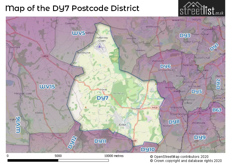
When it comes to local government, postal geography often disregards political borders. However, for a breakdown in the DY7 District: the district mostly encompasses the South Staffordshire District (331 postcodes), followed by the Shropshire area (5 postcodes), and finally, the Dudley District (B) area (4 postcodes).
Recent House Sales in DY7
| Date | Price | Address |
|---|---|---|
| 06/10/2023 | £310,000 | Huntsmans Drive, Kinver, Stourbridge, DY7 6BA |
| 31/08/2023 | £510,000 | Church View Gardens, Kinver, Stourbridge, DY7 6EF |
| 30/08/2023 | £517,500 | Laburnum Close, Kinver, Stourbridge, DY7 6BJ |
| 18/08/2023 | £592,500 | Enville Road, Kinver, Stourbridge, DY7 6BN |
| 04/08/2023 | £225,000 | Huntsmans Drive, Kinver, Stourbridge, DY7 6BA |
| 24/07/2023 | £695,000 | Bridgnorth Road, Stourton, Stourbridge, DY7 6SF |
| 13/07/2023 | £243,000 | New Wood Close, Stourbridge, DY7 6SN |
| 12/07/2023 | £365,000 | Compton Gardens, Kinver, Stourbridge, DY7 6DS |
| 07/07/2023 | £320,000 | Wicket Lane, Stourbridge, DY7 5PD |
| 05/07/2023 | £199,800 | Church Hill, Kinver, Stourbridge, DY7 6HX |
Weather Forecast for DY7
Press Button to Show Forecast for Wall Heath
| Time Period | Icon | Description | Temperature | Rain Probability | Wind |
|---|---|---|---|---|---|
| 06:00 to 09:00 | Cloudy | 5.0°C (feels like 3.0°C) | 47.00% | SSW 4 mph | |
| 09:00 to 12:00 | Cloudy | 8.0°C (feels like 6.0°C) | 6.00% | WNW 9 mph | |
| 12:00 to 15:00 | Cloudy | 10.0°C (feels like 7.0°C) | 6.00% | NW 9 mph | |
| 15:00 to 18:00 | Cloudy | 9.0°C (feels like 7.0°C) | 31.00% | N 9 mph | |
| 18:00 to 21:00 | Cloudy | 8.0°C (feels like 6.0°C) | 6.00% | NNE 7 mph | |
| 21:00 to 00:00 | Cloudy | 7.0°C (feels like 6.0°C) | 5.00% | NE 4 mph |
Press Button to Show Forecast for Wall Heath
| Time Period | Icon | Description | Temperature | Rain Probability | Wind |
|---|---|---|---|---|---|
| 00:00 to 03:00 | Cloudy | 5.0°C (feels like 4.0°C) | 7.00% | E 4 mph | |
| 03:00 to 06:00 | Cloudy | 4.0°C (feels like 2.0°C) | 8.00% | E 4 mph | |
| 06:00 to 09:00 | Cloudy | 4.0°C (feels like 2.0°C) | 7.00% | ENE 4 mph | |
| 09:00 to 12:00 | Cloudy | 7.0°C (feels like 5.0°C) | 6.00% | ENE 7 mph | |
| 12:00 to 15:00 | Cloudy | 9.0°C (feels like 8.0°C) | 7.00% | NNE 4 mph | |
| 15:00 to 18:00 | Cloudy | 10.0°C (feels like 9.0°C) | 9.00% | ENE 4 mph | |
| 18:00 to 21:00 | Cloudy | 9.0°C (feels like 8.0°C) | 9.00% | ENE 4 mph | |
| 21:00 to 00:00 | Partly cloudy (night) | 6.0°C (feels like 4.0°C) | 8.00% | ENE 7 mph |
Press Button to Show Forecast for Wall Heath
| Time Period | Icon | Description | Temperature | Rain Probability | Wind |
|---|---|---|---|---|---|
| 00:00 to 03:00 | Partly cloudy (night) | 4.0°C (feels like 2.0°C) | 8.00% | ENE 7 mph | |
| 03:00 to 06:00 | Cloudy | 3.0°C (feels like 1.0°C) | 12.00% | NE 4 mph | |
| 06:00 to 09:00 | Cloudy | 4.0°C (feels like 1.0°C) | 10.00% | NE 7 mph | |
| 09:00 to 12:00 | Cloudy | 8.0°C (feels like 5.0°C) | 15.00% | ENE 9 mph | |
| 12:00 to 15:00 | Overcast | 9.0°C (feels like 7.0°C) | 21.00% | ENE 9 mph | |
| 15:00 to 18:00 | Overcast | 10.0°C (feels like 8.0°C) | 23.00% | ENE 9 mph | |
| 18:00 to 21:00 | Overcast | 10.0°C (feels like 8.0°C) | 20.00% | ENE 9 mph | |
| 21:00 to 00:00 | Cloudy | 8.0°C (feels like 5.0°C) | 20.00% | NE 11 mph |
Press Button to Show Forecast for Wall Heath
| Time Period | Icon | Description | Temperature | Rain Probability | Wind |
|---|---|---|---|---|---|
| 00:00 to 03:00 | Cloudy | 7.0°C (feels like 4.0°C) | 19.00% | NE 9 mph | |
| 03:00 to 06:00 | Cloudy | 7.0°C (feels like 3.0°C) | 25.00% | NNE 11 mph | |
| 06:00 to 09:00 | Heavy rain | 7.0°C (feels like 4.0°C) | 75.00% | NNE 11 mph | |
| 09:00 to 12:00 | Heavy rain | 8.0°C (feels like 5.0°C) | 77.00% | NNE 11 mph | |
| 12:00 to 15:00 | Light rain | 9.0°C (feels like 6.0°C) | 55.00% | N 13 mph | |
| 15:00 to 18:00 | Light rain | 10.0°C (feels like 7.0°C) | 54.00% | NNE 11 mph | |
| 18:00 to 21:00 | Light rain shower (day) | 10.0°C (feels like 8.0°C) | 38.00% | N 9 mph | |
| 21:00 to 00:00 | Clear night | 7.0°C (feels like 5.0°C) | 11.00% | N 7 mph |
Where is the DY7 Postcode District?
The postcode district DY7 is located in Stourbridge, which is a district town. Nearby towns include Kingswinford to the north east (3.34 miles away), Brierley Hill to the east (4.95 miles away), Kidderminster to the south (6.59 miles away), Bewdley to the south west (7.43 miles away), and Bridgnorth to the west (8.59 miles away). The distance from DY7 to London is 112.30 miles.
The district is within the post town of STOURBRIDGE.
The sector has postcodes within the nation of England.
The DY7 Postcode District is covers the following regions.
- Staffordshire CC - Shropshire and Staffordshire - West Midlands (England)
- Shropshire CC - Shropshire and Staffordshire - West Midlands (England)
- Worcestershire - Herefordshire, Worcestershire and Warwickshire - West Midlands (England)
- Dudley - West Midlands - West Midlands (England)
| Postcode Sector | Delivery Office |
|---|---|
| DY7 5 | Stourbridge Delivery Office |
| DY7 6 | Stourbridge Delivery Office |
| DY7 6 | Kinver Scale Payment Delivery Office |
| D | Y | 7 | - | X | X | X |
| D | Y | 7 | Space | Numeric | Letter | Letter |
Tourist Attractions within the Postcode Area
We found 1 visitor attractions within the DY7 postcode area
| Kinver Edge and the Rock Houses |
|---|
| Historic Properties |
| Historic House / House and Garden / Palace |
| View Kinver Edge and the Rock Houses on Google Maps |
Current Monthly Rental Prices
| # Bedrooms | Min Price | Max Price | Avg Price |
|---|---|---|---|
| 2 | £795 | £1,250 | £1,023 |
| 4 | £1,250 | £1,250 | £1,250 |
Current House Prices
| # Bedrooms | Min Price | Max Price | Avg Price |
|---|---|---|---|
| £269,950 | £269,950 | £269,950 | |
| 1 | £109,950 | £219,950 | £166,617 |
| 2 | £145,000 | £550,000 | £301,150 |
| 3 | £250,000 | £725,000 | £408,289 |
| 4 | £325,000 | £925,000 | £626,437 |
| 5 | £525,000 | £1,750,000 | £940,556 |
| 6 | £795,000 | £795,000 | £795,000 |
Estate Agents who Operate in the DY7 District
| Logo | Name | Brand Name | Address | Contact Number | Total Properties |
|---|---|---|---|---|---|
 | Kinver | Eden Midcalf | 28 High Street, Kinver, DY7 6HF | 01384 437912 | 28 |
 | Stourbridge | Taylors Estate Agents | 85 High Street, Stourbridge, DY8 1ED | 01384 437336 | 9 |
 | Stourbridge | The Lee Shaw Partnership | Worcester House, 64 Hagley Road, Stourbridge, DY8 1QD | 01384 396066 | 7 |
 | Stourbridge | Lex Allan | The Auction House, 87/88 St. Johns Road, Stourbridge, DY8 1EH | 01384 437225 | 5 |
 | Stourbridge | Hunters | 11a St John's Road. Stourbridge, DY8 1EJ | 01384 437723 | 3 |
| Type of Property | 2018 Average | 2018 Sales | 2017 Average | 2017 Sales | 2016 Average | 2016 Sales | 2015 Average | 2015 Sales |
|---|---|---|---|---|---|---|---|---|
| Detached | £422,667 | 60 | £408,778 | 52 | £379,504 | 53 | £416,900 | 74 |
| Semi-Detached | £254,043 | 23 | £255,783 | 43 | £223,125 | 18 | £233,019 | 32 |
| Terraced | £237,417 | 18 | £262,911 | 18 | £222,697 | 18 | £238,711 | 14 |
| Flats | £185,857 | 7 | £213,844 | 19 | £187,747 | 59 | £144,188 | 8 |