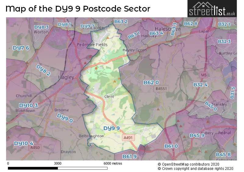
The DY9 9 postcode sector stands on the West Midlands and Worcestershire border.
Did you know? According to the 2021 Census, the DY9 9 postcode sector is home to a bustling 8,120 residents!
Given that each sector allows for 400 unique postcode combinations. Letters C, I, K, M, O and V are not allowed in the last two letters of a postcode. With 212 postcodes already in use, this leaves 188 units available.
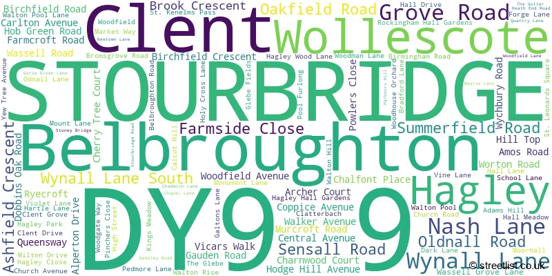
The largest settlement in the DY9 9 postal code is STOURBRIDGE followed by Belbroughton, and Clent.
The DY9 9 Postcode shares a border with B61 9 (Dodford, Fairfield, Bournheath), B62 0 (HALESOWEN, Romsley, Hunnington), DY9 0 (STOURBRIDGE, Hagley, Belbroughton), B61 0 (BROMSGROVE, Catshill, Marlbrook), B63 1 (HALESOWEN, Hayley Green, Hasbury), B63 2 (HALESOWEN), DY9 7 (STOURBRIDGE) and DY9 8 (STOURBRIDGE, Lye).
The sector is within the post town of STOURBRIDGE.
DY9 9 is a postcode sector within the DY9 postcode district which is within the DY Dudley postcode area.
The Royal Mail delivery office for the DY9 9 postal sector is the Stourbridge Delivery Office.
The area of the DY9 9 postcode sector is 7.60 square miles which is 19.67 square kilometres or 4,861.75 square acres.

Map of the DY9 9 Postcode Sector
Explore the DY9 9 postcode sector by using our free interactive map.
| D | Y | 9 | - | 9 | X | X |
| D | Y | 9 | Space | 9 | Letter | Letter |
Official List of Streets
Clent (22 Streets)
STOURBRIDGE (36 Streets)
Belbroughton (31 Streets)
Hagley (15 Streets)
Unofficial Streets or Alternative Spellings
Belbroughton
CHURCH HILL QUEENS HILLRomsley
FARLEY LANE MUNCHES LANE SHUT MILL LANEHayley Green
HAGLEY ROADHagley
KIDDERMINSTER ROAD PARK ROAD STOURBRIDGE ROAD BONFIRE HILL CLATTERBACH LANE COBHAM COURT MEWS ELSIE HARTINGTON WALK HAGLEY CAUSEWAY HAGLEY HILL HIGHFIELD LANE HILL LANE HILLTOP HOSSIL LANE MOOR HALL DRIVE THE ORANGERY WASSELL GROVE ROADSTOURBRIDGE
BIRCHGATE BROUGHTON ROAD DREW ROAD HAGLEY ROAD SANDHURST AVENUE SEYMOUR ROAD WOLLESCOTE ROADHALESOWEN
FOXCOTE LANEHALESOWEN,
OLDNALL ROADClent
FIELD LANE HOLY CROSS GREENBlakedown
BROOME LANEWeather Forecast for DY9 9
Press Button to Show Forecast for Hagley
| Time Period | Icon | Description | Temperature | Rain Probability | Wind |
|---|---|---|---|---|---|
| 18:00 to 21:00 | Overcast | 10.0°C (feels like 8.0°C) | 10.00% | NNE 9 mph | |
| 21:00 to 00:00 | Overcast | 8.0°C (feels like 7.0°C) | 9.00% | NNE 7 mph |
Press Button to Show Forecast for Hagley
| Time Period | Icon | Description | Temperature | Rain Probability | Wind |
|---|---|---|---|---|---|
| 00:00 to 03:00 | Overcast | 7.0°C (feels like 5.0°C) | 8.00% | N 4 mph | |
| 03:00 to 06:00 | Light rain | 6.0°C (feels like 5.0°C) | 38.00% | NE 4 mph | |
| 06:00 to 09:00 | Cloudy | 6.0°C (feels like 4.0°C) | 5.00% | NNE 4 mph | |
| 09:00 to 12:00 | Cloudy | 7.0°C (feels like 4.0°C) | 4.00% | NNE 7 mph | |
| 12:00 to 15:00 | Cloudy | 9.0°C (feels like 7.0°C) | 4.00% | N 9 mph | |
| 15:00 to 18:00 | Partly cloudy (day) | 10.0°C (feels like 8.0°C) | 1.00% | NNW 9 mph | |
| 18:00 to 21:00 | Partly cloudy (day) | 10.0°C (feels like 8.0°C) | 1.00% | NNW 7 mph | |
| 21:00 to 00:00 | Clear night | 7.0°C (feels like 5.0°C) | 1.00% | N 7 mph |
Press Button to Show Forecast for Hagley
| Time Period | Icon | Description | Temperature | Rain Probability | Wind |
|---|---|---|---|---|---|
| 00:00 to 03:00 | Clear night | 4.0°C (feels like 2.0°C) | 1.00% | WNW 4 mph | |
| 03:00 to 06:00 | Cloudy | 3.0°C (feels like 2.0°C) | 4.00% | W 4 mph | |
| 06:00 to 09:00 | Cloudy | 4.0°C (feels like 2.0°C) | 5.00% | WSW 4 mph | |
| 09:00 to 12:00 | Cloudy | 7.0°C (feels like 5.0°C) | 7.00% | WNW 7 mph | |
| 12:00 to 15:00 | Overcast | 10.0°C (feels like 8.0°C) | 11.00% | NW 9 mph | |
| 15:00 to 18:00 | Cloudy | 10.0°C (feels like 9.0°C) | 8.00% | NNW 9 mph | |
| 18:00 to 21:00 | Partly cloudy (day) | 9.0°C (feels like 8.0°C) | 3.00% | NNW 7 mph | |
| 21:00 to 00:00 | Partly cloudy (night) | 7.0°C (feels like 5.0°C) | 2.00% | NNE 4 mph |
Press Button to Show Forecast for Hagley
| Time Period | Icon | Description | Temperature | Rain Probability | Wind |
|---|---|---|---|---|---|
| 00:00 to 03:00 | Cloudy | 5.0°C (feels like 4.0°C) | 7.00% | E 4 mph | |
| 03:00 to 06:00 | Cloudy | 4.0°C (feels like 3.0°C) | 11.00% | ESE 4 mph | |
| 06:00 to 09:00 | Cloudy | 4.0°C (feels like 2.0°C) | 14.00% | E 4 mph | |
| 09:00 to 12:00 | Cloudy | 7.0°C (feels like 4.0°C) | 14.00% | ESE 7 mph | |
| 12:00 to 15:00 | Overcast | 9.0°C (feels like 7.0°C) | 17.00% | ESE 7 mph | |
| 15:00 to 18:00 | Overcast | 10.0°C (feels like 8.0°C) | 19.00% | ESE 7 mph | |
| 18:00 to 21:00 | Cloudy | 9.0°C (feels like 7.0°C) | 21.00% | ENE 7 mph | |
| 21:00 to 00:00 | Cloudy | 7.0°C (feels like 5.0°C) | 20.00% | ENE 7 mph |
Press Button to Show Forecast for Hagley
| Time Period | Icon | Description | Temperature | Rain Probability | Wind |
|---|---|---|---|---|---|
| 00:00 to 03:00 | Overcast | 6.0°C (feels like 4.0°C) | 23.00% | ENE 7 mph | |
| 03:00 to 06:00 | Cloudy | 6.0°C (feels like 3.0°C) | 22.00% | ENE 7 mph | |
| 06:00 to 09:00 | Cloudy | 6.0°C (feels like 3.0°C) | 19.00% | E 7 mph | |
| 09:00 to 12:00 | Overcast | 8.0°C (feels like 5.0°C) | 20.00% | ENE 9 mph | |
| 12:00 to 15:00 | Cloudy | 10.0°C (feels like 8.0°C) | 23.00% | E 9 mph | |
| 15:00 to 18:00 | Cloudy | 11.0°C (feels like 9.0°C) | 20.00% | ENE 9 mph | |
| 18:00 to 21:00 | Light rain | 10.0°C (feels like 8.0°C) | 45.00% | NE 9 mph | |
| 21:00 to 00:00 | Cloudy | 9.0°C (feels like 7.0°C) | 18.00% | NNE 9 mph |
Schools and Places of Education Within the DY9 9 Postcode Sector
Belbroughton CofE Primary School
Voluntary controlled school
Bradford Lane, Stourbridge, West Midlands, DY9 9TF
Head: Mrs Clare Bishop
Ofsted Rating: Good
Inspection: 2019-11-13 (1623 days ago)
Website: Visit Belbroughton CofE Primary School Website
Phone: 01562730208
Number of Pupils: 168
Clent Parochial Primary School
Voluntary controlled school
Clent Parochial Primary School, Clent, West Midlands, DY9 9QP
Head: Mrs Elisabeth Hyland
Ofsted Rating: Good
Inspection: 2022-03-03 (782 days ago)
Website: Visit Clent Parochial Primary School Website
Phone: 01562730668
Number of Pupils: 108
Hob Green Primary School
Academy converter
Hob Green Road, Stourbridge, West Midlands, DY9 9EX
Head: Mrs Lucy Williams
Ofsted Rating: Good
Inspection: 2019-05-22 (1798 days ago)
Website: Visit Hob Green Primary School Website
Phone: 01384210288
Number of Pupils: 242
Sunfield Children's Home Ltd
Other independent special school
Clent Grove, Stourbridge, West Midlands, DY9 9PB
Head: Mrs Sarah Whittington
Ofsted Rating: Good
Inspection: 2021-11-18 (887 days ago)
Website: Visit Sunfield Children's Home Ltd Website
Phone: 01562882253
Number of Pupils: 43
House Prices in the DY9 9 Postcode Sector
| Type of Property | 2018 Average | 2018 Sales | 2017 Average | 2017 Sales | 2016 Average | 2016 Sales | 2015 Average | 2015 Sales |
|---|---|---|---|---|---|---|---|---|
| Detached | £591,741 | 29 | £452,094 | 32 | £462,216 | 29 | £407,080 | 28 |
| Semi-Detached | £207,931 | 55 | £184,469 | 44 | £193,702 | 43 | £176,282 | 49 |
| Terraced | £214,894 | 26 | £203,496 | 14 | £214,739 | 23 | £199,060 | 24 |
| Flats | £165,850 | 10 | £183,809 | 11 | £129,000 | 7 | £163,556 | 8 |
Important Postcodes DY9 9 in the Postcode Sector
DY9 9DS is the postcode for Whychbury Medical Centre, 121 Oakfield Road
DY9 9EX is the postcode for Hob Green Primary School, Hob Green Road
DY9 9PB is the postcode for ST.MARYS AND SCHOOL BLOCK, Sunfield Childrens Home, Clent Grove, and MAIN HOUSE, Sunfield Childrens Home, Clent Grove
DY9 9QP is the postcode for Clent Parochial Primary School, Bromsgrove Road
DY9 9TF is the postcode for Belbroughton C of E Primary School & Nursery, Bradford Lane, and Belbroughton C of E Primary School & Nursery, Bradford Lane, Belbroughton
DY9 9TH is the postcode for The Glebeland Surgery, The Glebe
DY9 9UU is the postcode for Bell Heath C S Centre, Quantry Lane
| The DY9 9 Sector is within these Local Authorities |
|
|---|---|
| The DY9 9 Sector is within these Counties |
|
| The DY9 9 Sector is within these Water Company Areas |
|
Tourist Attractions within the DY9 9 Postcode Area
We found 1 visitor attractions within the DY9 postcode area
| Clent Hills |
|---|
| Historic Properties |
| Historic House / House and Garden / Palace |
| View Clent Hills on Google Maps |