The E13 8 postcode sector is within the county of Greater London.
Did you know? According to the 2021 Census, the E13 8 postcode sector is home to a bustling 15,246 residents!
Given that each sector allows for 400 unique postcode combinations. Letters C, I, K, M, O and V are not allowed in the last two letters of a postcode. With 191 postcodes already in use, this leaves 209 units available.
The E13 8 postal code covers the settlement of PLAISTOW .
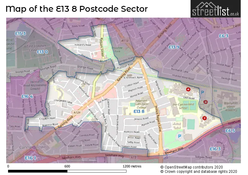
The E13 8 Postcode shares a border with E13 0 (PLAISTOW , UPTON PARK , STRATFORD ), E6 3 (EAST HAM ), E6 5 (BECKTON , EAST HAM ), E13 9 (PLAISTOW , UPTON PARK , EAST HAM ), E16 3 (WEST BECKTON , CANNING TOWN ) and E16 4 (CANNING TOWN , PLAISTOW ).
The sector is within the post town of LONDON.
E13 8 is a postcode sector within the E13 postcode district which is within the E East London postcode area.
The Royal Mail delivery office for the E13 8 postal sector is the Plaistow Sdelivery Office.
The area of the E13 8 postcode sector is 0.49 square miles which is 1.27 square kilometres or 313.66 square acres.

Map of the E13 8 Postcode Sector
Explore the E13 8 postcode sector by using our free interactive map.
| E | 1 | 3 | - | 8 | X | X |
| E | 1 | 3 | Space | 8 | Letter | Letter |
Official List of Streets
Newham (98 Streets)
Unofficial Streets or Alternative Spellings
Newham
BETHELL AVENUE BLANCHE STREET CHESTERTON TERRACE CLIFF WALK DONGOLA ROAD EDWARD STREET FREEMASONS ROAD GRANGE ROAD GREENGATE STREET HAYDAY ROAD LONDON ROAD MEREDITH STREET NEWHAM WAY RAVENSCROFT ROAD SUFFOLK ROAD SWETE STREET TOLLGATE ROAD UPPER ROAD WINKFIELD ROADWeather Forecast for E13 8
Press Button to Show Forecast for West Ham United F.C.
| Time Period | Icon | Description | Temperature | Rain Probability | Wind |
|---|---|---|---|---|---|
| 03:00 to 06:00 | Cloudy | 7.0°C (feels like 6.0°C) | 6.00% | SSW 4 mph | |
| 06:00 to 09:00 | Cloudy | 7.0°C (feels like 5.0°C) | 7.00% | WSW 7 mph | |
| 09:00 to 12:00 | Cloudy | 9.0°C (feels like 7.0°C) | 8.00% | W 9 mph | |
| 12:00 to 15:00 | Overcast | 11.0°C (feels like 9.0°C) | 9.00% | W 9 mph | |
| 15:00 to 18:00 | Cloudy | 12.0°C (feels like 10.0°C) | 14.00% | WNW 9 mph | |
| 18:00 to 21:00 | Cloudy | 10.0°C (feels like 8.0°C) | 12.00% | N 7 mph | |
| 21:00 to 00:00 | Cloudy | 8.0°C (feels like 7.0°C) | 8.00% | ENE 7 mph |
Press Button to Show Forecast for West Ham United F.C.
| Time Period | Icon | Description | Temperature | Rain Probability | Wind |
|---|---|---|---|---|---|
| 00:00 to 03:00 | Cloudy | 7.0°C (feels like 6.0°C) | 5.00% | ENE 4 mph | |
| 03:00 to 06:00 | Cloudy | 6.0°C (feels like 4.0°C) | 5.00% | NE 4 mph | |
| 06:00 to 09:00 | Cloudy | 6.0°C (feels like 4.0°C) | 5.00% | NE 4 mph | |
| 09:00 to 12:00 | Cloudy | 8.0°C (feels like 6.0°C) | 5.00% | ENE 7 mph | |
| 12:00 to 15:00 | Overcast | 10.0°C (feels like 8.0°C) | 11.00% | E 7 mph | |
| 15:00 to 18:00 | Overcast | 10.0°C (feels like 9.0°C) | 15.00% | E 7 mph | |
| 18:00 to 21:00 | Cloudy | 10.0°C (feels like 8.0°C) | 13.00% | E 9 mph | |
| 21:00 to 00:00 | Cloudy | 8.0°C (feels like 6.0°C) | 13.00% | E 7 mph |
Press Button to Show Forecast for West Ham United F.C.
| Time Period | Icon | Description | Temperature | Rain Probability | Wind |
|---|---|---|---|---|---|
| 00:00 to 03:00 | Light rain | 7.0°C (feels like 6.0°C) | 46.00% | ENE 7 mph | |
| 03:00 to 06:00 | Light rain | 7.0°C (feels like 5.0°C) | 48.00% | ENE 7 mph | |
| 06:00 to 09:00 | Overcast | 7.0°C (feels like 5.0°C) | 21.00% | ENE 7 mph | |
| 09:00 to 12:00 | Cloudy | 10.0°C (feels like 8.0°C) | 17.00% | E 9 mph | |
| 12:00 to 15:00 | Cloudy | 12.0°C (feels like 10.0°C) | 17.00% | E 9 mph | |
| 15:00 to 18:00 | Light rain | 13.0°C (feels like 11.0°C) | 52.00% | E 9 mph | |
| 18:00 to 21:00 | Overcast | 12.0°C (feels like 10.0°C) | 22.00% | E 9 mph | |
| 21:00 to 00:00 | Light rain | 11.0°C (feels like 9.0°C) | 51.00% | ENE 9 mph |
Press Button to Show Forecast for West Ham United F.C.
| Time Period | Icon | Description | Temperature | Rain Probability | Wind |
|---|---|---|---|---|---|
| 00:00 to 03:00 | Light rain | 10.0°C (feels like 9.0°C) | 53.00% | ENE 7 mph | |
| 03:00 to 06:00 | Light rain | 10.0°C (feels like 8.0°C) | 53.00% | E 7 mph | |
| 06:00 to 09:00 | Light rain | 10.0°C (feels like 8.0°C) | 51.00% | ESE 7 mph | |
| 09:00 to 12:00 | Light rain shower (day) | 11.0°C (feels like 9.0°C) | 43.00% | SSE 9 mph | |
| 12:00 to 15:00 | Heavy rain shower (day) | 13.0°C (feels like 11.0°C) | 59.00% | S 11 mph | |
| 15:00 to 18:00 | Heavy rain shower (day) | 14.0°C (feels like 12.0°C) | 55.00% | S 11 mph | |
| 18:00 to 21:00 | Partly cloudy (day) | 13.0°C (feels like 11.0°C) | 14.00% | SW 9 mph | |
| 21:00 to 00:00 | Partly cloudy (night) | 11.0°C (feels like 10.0°C) | 7.00% | SSW 7 mph |
Schools and Places of Education Within the E13 8 Postcode Sector
Cumberland Community School
Academy sponsor led
Oban Close, London, , E13 8SJ
Head: Mr Ekhlas Rahman
Ofsted Rating: Good
Inspection: 2022-09-29 (574 days ago)
Website: Visit Cumberland Community School Website
Phone: 02074740231
Number of Pupils: 1417
Newham Sixth Form College
Further education
Prince Regent Lane, London, , E13 8SG
Head: Mr Mandeep Gill
Ofsted Rating: Good
Inspection: 2018-12-07 (1966 days ago)
Website: Visit Newham Sixth Form College Website
Phone: 02074734110
Number of Pupils: 0
St Helen's Catholic Primary School
Academy converter
Chargeable Lane, London, , E13 8DW
Head: Miss Claire Doherty
Ofsted Rating: Outstanding
Inspection: 2022-12-07 (505 days ago)
Website: Visit St Helen's Catholic Primary School Website
Phone: 02074761785
Number of Pupils: 474
Tollgate Primary School
Academy converter
Barclay Road, London, , E13 8SA
Head: Mrs Emma O'Connor
Ofsted Rating: Outstanding
Inspection: 2022-12-08 (504 days ago)
Website: Visit Tollgate Primary School Website
Phone: 02074761848
Number of Pupils: 437
House Prices in the E13 8 Postcode Sector
| Type of Property | 2018 Average | 2018 Sales | 2017 Average | 2017 Sales | 2016 Average | 2016 Sales | 2015 Average | 2015 Sales |
|---|---|---|---|---|---|---|---|---|
| Detached | £0 | 0 | £700,000 | 1 | £608,333 | 3 | £380,000 | 2 |
| Semi-Detached | £457,625 | 4 | £507,500 | 2 | £332,500 | 2 | £259,999 | 4 |
| Terraced | £388,372 | 43 | £370,638 | 61 | £359,993 | 70 | £308,806 | 76 |
| Flats | £277,047 | 32 | £232,773 | 43 | £230,321 | 56 | £193,378 | 46 |
Important Postcodes E13 8 in the Postcode Sector
E13 8AF is the postcode for Balaam Park Health Centre, 113 Balaam Street
E13 8AL is the postcode for York House, 411 Barking Road, 409, Barking Road, and York House, 411 Barking Road, Plaistow
E13 8AQ is the postcode for Balaam Leisure Centre, Balaam Street
E13 8DD is the postcode for St. Helens RC Primary School, Falcon Street
E13 8DW is the postcode for The Resource Centre, 200 Chargeable Lane, Plaistow, Later Years Centre, 200 Chargeable Lane, London Borough of Newham, Resources Centres for Elders, 200 Chargeable Lane, St. Helens Catholic Primary School, Chargeable Lane, and London Borough of Newham, Resources Centres for Elders
E13 8EB is the postcode for Plaistow Jobcentre, 3-9 Balaam Street
E13 8HJ is the postcode for Metropolitan Police, Plaistow Police Station, 444 Barking Road, and METROPOLITAN POLICE, Metropolitan Police, Plaistow Police Station, 444 Barking Road
E13 8LF is the postcode for Kaizen Primary School, Elkington Road
E13 8LS is the postcode for Doctors Surgery, 179 Cumberland Road
E13 8RY is the postcode for LONDON FIRE & EMERGENCY PLANNING AUTHORITY PLAISTOW FIRE STATION, Plaistow Fire Station, 145 Prince Regent Lane, and Plaistow Fire Station, 145 Prince Regent Lane
E13 8SA is the postcode for LONDON BOROUGH OF NEWHAM, Tollgate Primary School, Barclay Road, and Tollgate Primary School, Barclay Road
E13 8SD is the postcode for Newham Leisure Centre, 281 Prince Regent Lane
E13 8SG is the postcode for BLOCK F, Newham Sixth Form College, Prince Regent Lane, A-BLOCK, Newham Sixth Form College, Prince Regent Lane, BLOCK B, Newham Sixth Form College, Prince Regent Lane, and BLOCK C AND D, Newham Sixth Form College, Prince Regent Lane
E13 8SJ is the postcode for Cumberland School Specialist Sports College, Oban Close
E13 8SL is the postcode for Newham University Hospital NHS Trust, Newham General Hospital, Newham University Hospital, Glen Road, and GATEWAY SURGICAL CENTRE NEWHAM UNIVERSITY HOSPITAL, Newham University Hospital, Glen Road
E13 8SP is the postcode for COBURN ADOLESCENT UNIT, Newham Centre for Mental Health, Glen Road, DAY HOSPITAL/ACADEMIC CENTRE, Newham Centre for Mental Health, Glen Road, and NEWHAM CENTRE FOR MENTAL HEALTH, Newham Centre for Mental Health, Glen Road
| The E13 8 Sector is within these Local Authorities |
|
|---|---|
| The E13 8 Sector is within these Counties |
|
| The E13 8 Sector is within these Water Company Areas |
|