The E14 postcode district is a postal district located in the E London - E postcode area with a population of 108,214 residents according to the 2021 England and Wales Census.
The area of the E14 postcode district is 2.72 square miles which is 7.04 square kilometres or 1,738.94 acres.
Currently, the E14 district has about 1802 postcode units spread across 9 geographic postcode sectors.
Given that each sector allows for 400 unique postcode combinations, the district has a capacity of 3,600 postcodes. With 1802 postcodes already in use, this leaves 1798 units available.
The E14 postal code covers the settlement of LONDON.
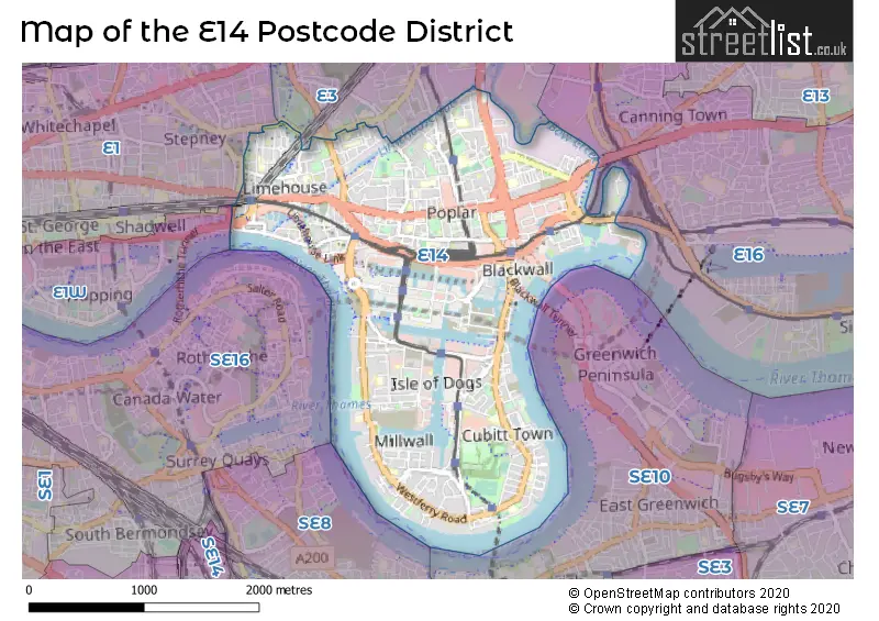
The postcode area has a boundary with Tidal Thames.
The E14 Postcode shares a border with E3 (LONDON), E1 (LONDON) and E16 (CANNING TOWN, NORTH WOOLWICH, SILVERTOWN).
The primary settlement in the E14 postcode district is Tower Hamlets, located in Greater London. There are also other significant settlements in this district, including London.
For the district E14, we have data on 10 postcode sectors. Here's a breakdown: The sector E14 0, covers Tower Hamlets in Greater London. The sector E14 1 is non-geographic. It's often designated for PO Boxes, large organisations, or special services. The sector E14 2, covers Tower Hamlets in Greater London. The sector E14 3, covers Tower Hamlets in Greater London. The sector E14 4, covers Tower Hamlets in Greater London. The sector E14 5, covers Tower Hamlets in Greater London. The sector E14 6, covers Tower Hamlets in Greater London. The sector E14 7, covers Tower Hamlets in Greater London. The sector E14 8, covers Tower Hamlets in Greater London. The sector E14 9, covers Tower Hamlets in Greater London.

Map of the E14 Postcode District
Explore the E14 postcode district by using our free interactive map.
When it comes to local government, postal geography often disregards political borders. However, for a breakdown in the E14 District: the district mostly encompasses the Tower Hamlets London Boro area with a total of 1885 postcodes.
Recent House Sales in E14
| Date | Price | Address |
|---|---|---|
| 23/10/2023 | £435,000 | Baltimore Wharf, London, E14 9FG |
| 12/10/2023 | £350,000 | Lyell Street, London, E14 0ST |
| 11/10/2023 | £365,000 | East India Dock Road, London, E14 0EG |
| 09/10/2023 | £500,000 | Barleycorn Way, London, E14 8DE |
| 09/10/2023 | £340,000 | Barleycorn Way, London, E14 8DE |
| 09/10/2023 | £725,000 | Cold Harbour, London, E14 9NU |
| 05/10/2023 | £390,000 | Orchard Place, London, E14 0WW |
| 04/10/2023 | £350,000 | Ship Yard, London, E14 3TR |
| 29/09/2023 | £990,000 | Woodstock Terrace, London, E14 0AD |
| 22/09/2023 | £550,000 | Baltimore Wharf, London, E14 9FT |
Weather Forecast for E14
Press Button to Show Forecast for Excel
| Time Period | Icon | Description | Temperature | Rain Probability | Wind |
|---|---|---|---|---|---|
| 00:00 to 03:00 | Cloudy | 7.0°C (feels like 6.0°C) | 5.00% | ENE 7 mph | |
| 03:00 to 06:00 | Cloudy | 6.0°C (feels like 4.0°C) | 4.00% | ENE 7 mph | |
| 06:00 to 09:00 | Cloudy | 6.0°C (feels like 4.0°C) | 5.00% | ENE 7 mph | |
| 09:00 to 12:00 | Cloudy | 8.0°C (feels like 6.0°C) | 5.00% | ENE 7 mph | |
| 12:00 to 15:00 | Overcast | 10.0°C (feels like 8.0°C) | 11.00% | E 7 mph | |
| 15:00 to 18:00 | Cloudy | 11.0°C (feels like 9.0°C) | 13.00% | E 7 mph | |
| 18:00 to 21:00 | Cloudy | 10.0°C (feels like 8.0°C) | 14.00% | E 9 mph | |
| 21:00 to 00:00 | Cloudy | 8.0°C (feels like 6.0°C) | 11.00% | E 7 mph |
Press Button to Show Forecast for Excel
| Time Period | Icon | Description | Temperature | Rain Probability | Wind |
|---|---|---|---|---|---|
| 00:00 to 03:00 | Light rain | 8.0°C (feels like 5.0°C) | 46.00% | ENE 7 mph | |
| 03:00 to 06:00 | Light rain | 7.0°C (feels like 5.0°C) | 47.00% | ENE 7 mph | |
| 06:00 to 09:00 | Overcast | 7.0°C (feels like 5.0°C) | 22.00% | ENE 7 mph | |
| 09:00 to 12:00 | Cloudy | 9.0°C (feels like 7.0°C) | 16.00% | E 9 mph | |
| 12:00 to 15:00 | Overcast | 12.0°C (feels like 10.0°C) | 18.00% | E 9 mph | |
| 15:00 to 18:00 | Light rain | 13.0°C (feels like 11.0°C) | 53.00% | E 9 mph | |
| 18:00 to 21:00 | Light rain | 12.0°C (feels like 10.0°C) | 53.00% | E 9 mph | |
| 21:00 to 00:00 | Light rain | 11.0°C (feels like 9.0°C) | 53.00% | ENE 9 mph |
Press Button to Show Forecast for Excel
| Time Period | Icon | Description | Temperature | Rain Probability | Wind |
|---|---|---|---|---|---|
| 00:00 to 03:00 | Light rain | 10.0°C (feels like 9.0°C) | 52.00% | ENE 7 mph | |
| 03:00 to 06:00 | Light rain | 10.0°C (feels like 8.0°C) | 53.00% | E 7 mph | |
| 06:00 to 09:00 | Light rain | 10.0°C (feels like 8.0°C) | 52.00% | ESE 7 mph | |
| 09:00 to 12:00 | Heavy rain shower (day) | 11.0°C (feels like 9.0°C) | 60.00% | SE 9 mph | |
| 12:00 to 15:00 | Light rain shower (day) | 13.0°C (feels like 11.0°C) | 44.00% | S 9 mph | |
| 15:00 to 18:00 | Light rain shower (day) | 14.0°C (feels like 12.0°C) | 39.00% | S 11 mph | |
| 18:00 to 21:00 | Partly cloudy (day) | 13.0°C (feels like 11.0°C) | 15.00% | S 9 mph | |
| 21:00 to 00:00 | Partly cloudy (night) | 11.0°C (feels like 10.0°C) | 7.00% | S 7 mph |
Where is the E14 Postcode District?
The postcode district E14 is located in the town of London. It is approximately 4.79 miles away from the center of London. The district is surrounded by several nearby towns, including Bromley by Bow to the north, Deptford to the south, Greenwich to the southeast, Canning Town to the northeast, Silvertown to the east, and New Cross to the southwest.
The district is within the post town of LONDON.
The sector has postcodes within the nation of England.
The E14 Postcode District is in the Tower Hamlets region of Inner London - East within the London.
You may be interested in our page explaining the evolution of London's Postcodes| Postcode Sector | Delivery Office |
|---|---|
| E14 0 | Docklands Delivery Office |
| E14 2 | Docklands Delivery Office |
| E14 3 | Docklands Delivery Office |
| E14 4 | Docklands Delivery Office |
| E14 5 | Docklands Delivery Office |
| E14 6 | Docklands Delivery Office |
| E14 7 | Docklands Delivery Office |
| E14 8 | Docklands Delivery Office |
| E14 9 | Docklands Delivery Office |
| E | 1 | 4 | - | X | X | X |
| E | 1 | 4 | Space | Numeric | Letter | Letter |
Tourist Attractions within the Postcode Area
We found 1 visitor attractions within the E14 postcode area
| Museum of London Docklands |
|---|
| Museums & Art Galleries |
| Museum and / or Art Gallery |
| View Museum of London Docklands on Google Maps |
Current Monthly Rental Prices
| # Bedrooms | Min Price | Max Price | Avg Price |
|---|---|---|---|
| £2,102 | £3,250 | £2,535 | |
| 1 | £2,100 | £3,900 | £2,608 |
| 2 | £2,100 | £6,500 | £3,533 |
| 3 | £2,200 | £9,995 | £4,759 |
| 4 | £2,900 | £7,999 | £4,284 |
| 5 | £3,500 | £10,000 | £5,249 |
| 6 | £4,420 | £5,720 | £5,233 |
| 7 | £5,503 | £6,067 | £5,785 |
Current House Prices
| # Bedrooms | Min Price | Max Price | Avg Price |
|---|---|---|---|
| £503,000 | £2,500,000 | £658,749 | |
| 1 | £500,000 | £1,075,000 | £684,620 |
| 2 | £500,000 | £5,100,000 | £864,194 |
| 3 | £500,000 | £3,500,000 | £1,215,200 |
| 4 | £525,000 | £9,250,000 | £1,377,811 |
| 5 | £849,995 | £1,000,000 | £924,998 |
| 6 | £825,000 | £3,650,000 | £2,237,500 |
Estate Agents who Operate in the E14 District
| Logo | Name | Brand Name | Address | Contact Number | Total Properties |
|---|---|---|---|---|---|
 | Canary Wharf | Foxtons | Unit 2, 20 Canada Square, London, E14 5NN | 020 3909 6450 | 125 |
 | Canary Wharf | JLL | 11 Westferry Circus, London, E14 4HE | 020 3909 7906 | 103 |
 | Canary Wharf | JOHNS&CO | 70 Marsh Wall, London, E14 9SL | 020 3910 0876 | 68 |
 | New Providence Wharf | JOHNS&CO | 8 New Providence Wharf, 1 Fairmont Avenue, London, E14 9PA | 020 3889 9105 | 67 |
 | London | OpenRent | 39 Great Windmill Street London W1D 7LX | 020 3322 3265 | 58 |
| Type of Property | 2018 Average | 2018 Sales | 2017 Average | 2017 Sales | 2016 Average | 2016 Sales | 2015 Average | 2015 Sales |
|---|---|---|---|---|---|---|---|---|
| Detached | £0 | 0 | £0 | 0 | £1,012,500 | 2 | £770,000 | 1 |
| Semi-Detached | £775,563 | 4 | £879,250 | 4 | £681,250 | 4 | £685,000 | 3 |
| Terraced | £670,223 | 68 | £639,343 | 67 | £677,664 | 84 | £597,266 | 121 |
| Flats | £505,209 | 1705 | £503,675 | 1734 | £484,188 | 2703 | £431,618 | 1803 |