The E15 postcode district is a postal district located in the E London - E postcode area with a population of 58,450 residents according to the 2021 England and Wales Census.
The area of the E15 postcode district is 2.74 square miles which is 7.10 square kilometres or 1,754.97 acres.
Currently, the E15 district has about 797 postcode units spread across 4 geographic postcode sectors.
Given that each sector allows for 400 unique postcode combinations, the district has a capacity of 1,600 postcodes. With 797 postcodes already in use, this leaves 803 units available.
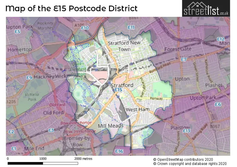
The E15 postal code covers the settlement of STRATFORD.
The E15 Postcode shares a border with E11 (LEYTONSTONE, WANSTEAD), E13 (PLAISTOW, UPTON PARK), E3 (LONDON), E16 (CANNING TOWN, NORTH WOOLWICH, SILVERTOWN), E7 (FOREST GATE) and E9 (HACKNEY).
The primary settlement in the E15 postcode district is Newham in Greater London. Other significant settlements in the district include Waltham Forest, Hackney, and Tower Hamlets, all located in Greater London. The most significant post town in the district is London. The county in which these settlements are located is Greater London, within England.
For the district E15, we have data on 5 postcode sectors. Here's a breakdown: The sector E15 1, covers Newham in Greater London. The sector E15 2, covers Newham and Waltham Forest in Greater London. The sector E15 3, covers Newham in Greater London. The sector E15 4, covers Newham in Greater London. The sector E15 9 is non-geographic. It's often designated for PO Boxes, large organisations, or special services.

Map of the E15 Postcode District
Explore the E15 postcode district by using our free interactive map.
When it comes to local government, postal geography often disregards political borders. However, for a breakdown in the E15 District: the district mostly encompasses the Newham London Boro (761 postcodes), followed by the Waltham Forest London Boro area (51 postcodes), and finally, the Hackney London Boro area (5 postcodes).
Recent House Sales in E15
| Date | Price | Address |
|---|---|---|
| 20/10/2023 | £625,000 | Great Eastern Road, London, E15 1DU |
| 09/10/2023 | £725,000 | Colegrave Road, London, E15 1ED |
| 29/09/2023 | £569,500 | Evesham Road, London, E15 4AJ |
| 22/09/2023 | £365,000 | High Street, Stratford, London, E15 2NZ |
| 08/09/2023 | £400,000 | Wise Road, London, E15 2FN |
| 01/09/2023 | £440,000 | Forrester Way, London, E15 1GL |
| 01/09/2023 | £860,000 | Great Eastern Road, London, E15 1DU |
| 31/08/2023 | £622,500 | Station Street, London, E15 1DA |
| 31/08/2023 | £312,500 | Forrester Way, London, E15 1GN |
| 31/08/2023 | £268,000 | Carnarvon Road, Stratford, London, E15 4LB |
Weather Forecast for E15
Press Button to Show Forecast for Londonolympic Park South
| Time Period | Icon | Description | Temperature | Rain Probability | Wind |
|---|---|---|---|---|---|
| 12:00 to 15:00 | Cloudy | 11.0°C (feels like 9.0°C) | 9.00% | W 11 mph | |
| 15:00 to 18:00 | Cloudy | 11.0°C (feels like 9.0°C) | 51.00% | W 9 mph | |
| 18:00 to 21:00 | Cloudy | 9.0°C (feels like 8.0°C) | 52.00% | NNW 7 mph | |
| 21:00 to 00:00 | Cloudy | 8.0°C (feels like 6.0°C) | 8.00% | ENE 7 mph |
Press Button to Show Forecast for Londonolympic Park South
| Time Period | Icon | Description | Temperature | Rain Probability | Wind |
|---|---|---|---|---|---|
| 00:00 to 03:00 | Cloudy | 7.0°C (feels like 5.0°C) | 5.00% | ENE 7 mph | |
| 03:00 to 06:00 | Cloudy | 6.0°C (feels like 4.0°C) | 5.00% | NE 7 mph | |
| 06:00 to 09:00 | Cloudy | 5.0°C (feels like 3.0°C) | 4.00% | NE 7 mph | |
| 09:00 to 12:00 | Cloudy | 8.0°C (feels like 6.0°C) | 4.00% | ENE 7 mph | |
| 12:00 to 15:00 | Cloudy | 11.0°C (feels like 9.0°C) | 11.00% | E 4 mph | |
| 15:00 to 18:00 | Cloudy | 11.0°C (feels like 10.0°C) | 13.00% | ENE 7 mph | |
| 18:00 to 21:00 | Cloudy | 10.0°C (feels like 9.0°C) | 13.00% | E 7 mph | |
| 21:00 to 00:00 | Cloudy | 8.0°C (feels like 6.0°C) | 11.00% | E 7 mph |
Press Button to Show Forecast for Londonolympic Park South
| Time Period | Icon | Description | Temperature | Rain Probability | Wind |
|---|---|---|---|---|---|
| 00:00 to 03:00 | Cloudy | 6.0°C (feels like 4.0°C) | 17.00% | ENE 7 mph | |
| 03:00 to 06:00 | Cloudy | 5.0°C (feels like 4.0°C) | 18.00% | NE 7 mph | |
| 06:00 to 09:00 | Cloudy | 6.0°C (feels like 4.0°C) | 19.00% | NE 7 mph | |
| 09:00 to 12:00 | Overcast | 10.0°C (feels like 8.0°C) | 18.00% | ENE 9 mph | |
| 12:00 to 15:00 | Cloudy | 12.0°C (feels like 10.0°C) | 14.00% | E 9 mph | |
| 15:00 to 18:00 | Light rain | 13.0°C (feels like 10.0°C) | 51.00% | E 11 mph | |
| 18:00 to 21:00 | Light rain | 11.0°C (feels like 9.0°C) | 53.00% | ENE 9 mph | |
| 21:00 to 00:00 | Light rain | 10.0°C (feels like 8.0°C) | 52.00% | ENE 11 mph |
Press Button to Show Forecast for Londonolympic Park South
| Time Period | Icon | Description | Temperature | Rain Probability | Wind |
|---|---|---|---|---|---|
| 00:00 to 03:00 | Heavy rain | 10.0°C (feels like 8.0°C) | 74.00% | NE 9 mph | |
| 03:00 to 06:00 | Light rain | 10.0°C (feels like 8.0°C) | 56.00% | ESE 9 mph | |
| 06:00 to 09:00 | Light rain | 10.0°C (feels like 8.0°C) | 50.00% | SE 7 mph | |
| 09:00 to 12:00 | Light rain shower (day) | 11.0°C (feels like 9.0°C) | 45.00% | SE 9 mph | |
| 12:00 to 15:00 | Heavy rain shower (day) | 13.0°C (feels like 11.0°C) | 61.00% | S 9 mph | |
| 15:00 to 18:00 | Light rain shower (day) | 14.0°C (feels like 12.0°C) | 39.00% | SSW 11 mph | |
| 18:00 to 21:00 | Partly cloudy (day) | 13.0°C (feels like 11.0°C) | 13.00% | SW 11 mph | |
| 21:00 to 00:00 | Cloudy | 11.0°C (feels like 9.0°C) | 9.00% | SSW 7 mph |
Where is the E15 Postcode District?
The data provided shows that the E15 postcode district is located in London. It is specifically situated in the district town of Stratford, which is very close to the center of London. Other nearby towns include Queen Elizabeth Olympic Park, Bromley by Bow, Forest Gate, and Leytonstone. The distance from the E15 postcode district to the center of London is approximately 5.96 miles.
The district is within the post town of LONDON.
The sector has postcodes within the nation of England.
The E15 Postcode District is covers the following regions.
- Hackney and Newham - Inner London - East - London
- Redbridge and Waltham Forest - Outer London - East and North East - London
- Tower Hamlets - Inner London - East - London
| Postcode Sector | Delivery Office |
|---|---|
| E15 1 | Stratford Sdelivery Office |
| E15 2 | Stratford Sdelivery Office |
| E15 3 | Stratford Sdelivery Office |
| E15 4 | Stratford Sdelivery Office |
| E | 1 | 5 | - | X | X | X |
| E | 1 | 5 | Space | Numeric | Letter | Letter |
Current Monthly Rental Prices
| # Bedrooms | Min Price | Max Price | Avg Price |
|---|---|---|---|
| £100 | £1,400 | £739 | |
| 1 | £750 | £3,250 | £1,782 |
| 2 | £1,800 | £5,500 | £2,488 |
| 3 | £1,900 | £5,500 | £3,350 |
| 4 | £2,800 | £3,750 | £3,308 |
| 5 | £2,500 | £4,500 | £3,500 |
| 6 | £3,900 | £3,900 | £3,900 |
Current House Prices
| # Bedrooms | Min Price | Max Price | Avg Price |
|---|---|---|---|
| £190,000 | £1,150,000 | £497,433 | |
| 1 | £105,000 | £500,000 | £329,474 |
| 2 | £102,500 | £725,000 | £418,154 |
| 3 | £325,000 | £950,000 | £566,626 |
| 4 | £520,000 | £850,000 | £738,182 |
| 5 | £625,000 | £950,000 | £715,000 |
Estate Agents who Operate in the E15 District
| Logo | Name | Brand Name | Address | Contact Number | Total Properties |
|---|---|---|---|---|---|
 | Stratford | Foxtons | 9 The Grove, London, E15 1EL | 020 3909 4203 | 61 |
 | Stratford | JLL | Unex Tower, 5 Station Street, London, E15 1DA | 020 3840 3310 | 40 |
 | Stratford | Bairstow Eves | 142 The Grove, Stratford, London, E15 1NS | 020 3873 5835 | 34 |
 | Stratford | Keatons | 152-154 The Grove, Stratford, E15 1NS | 020 3907 9979 | 18 |
 | Stratford | David Daniels | 49c Leytonstone Road, London, E15 1JA | 020 8555 3521 | 14 |
| Type of Property | 2018 Average | 2018 Sales | 2017 Average | 2017 Sales | 2016 Average | 2016 Sales | 2015 Average | 2015 Sales |
|---|---|---|---|---|---|---|---|---|
| Detached | £576,667 | 3 | £484,500 | 1 | £0 | 0 | £366,250 | 1 |
| Semi-Detached | £561,800 | 10 | £493,000 | 7 | £426,859 | 6 | £448,090 | 11 |
| Terraced | £477,958 | 198 | £496,849 | 160 | £457,210 | 201 | £406,763 | 236 |
| Flats | £434,211 | 689 | £367,996 | 718 | £311,938 | 361 | £298,840 | 561 |